Monthly Archives: agosto 2015

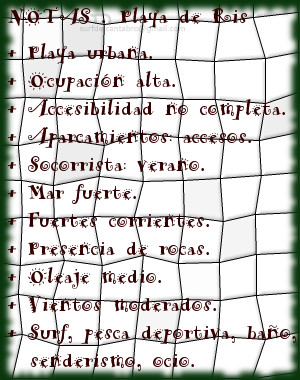
Noja, Playa de Ris .
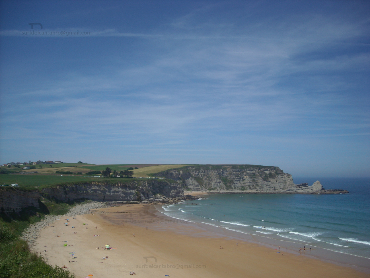
![]() La playa de Ris está ubicada en el municipio de Noja, perteneciente a la comarca de Trasmiera; en la costa occidental de Cantabria. Su longitud de 2200 metros y anchura media de 100 metros, junto con su emplazamiento urbano, hacen de ella una playa con un alto grado de ocupación.
La playa de Ris está ubicada en el municipio de Noja, perteneciente a la comarca de Trasmiera; en la costa occidental de Cantabria. Su longitud de 2200 metros y anchura media de 100 metros, junto con su emplazamiento urbano, hacen de ella una playa con un alto grado de ocupación.
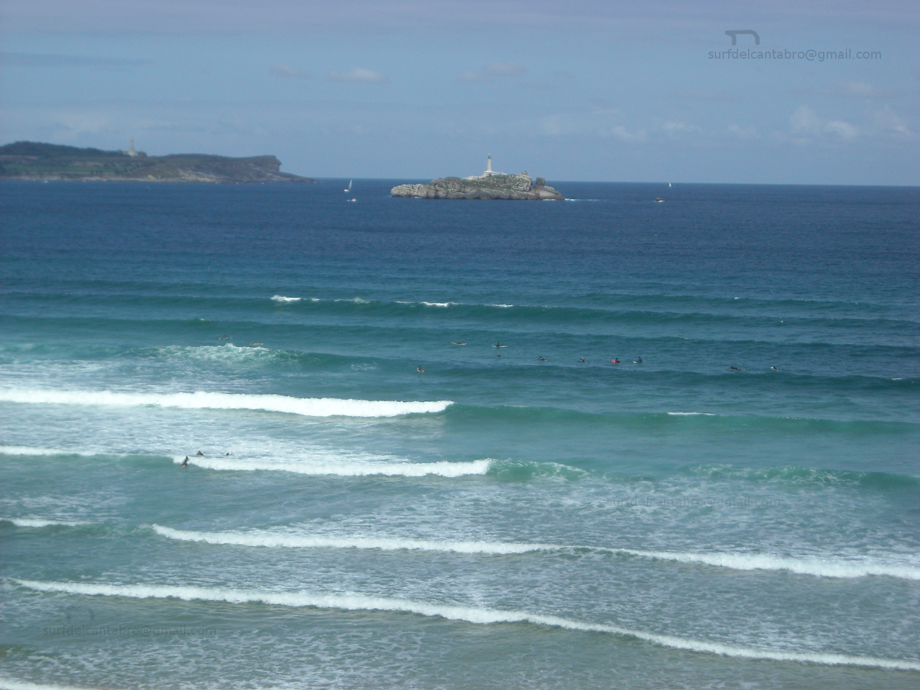
Este gran arenal tiene dos partes diferenciadas. Una de ellas, próxima a la Ría de Quejo, es una zona retirada, tranquila, situada en el límite de Las Marismas de Joyel (una de las tres partes que componen el Parque Natural de las Marismas de Santoña, Victoria y Joyel) y por ello se la conoce como Playa de Joyel. Gobernada por el ritmo de las mareas, que ocultan el 60% de la superficie de la playa con la pleamar. La otra zona, emplazada frente a Noja y delimitada en sus extremos por islotes rocosos, es la parte urbana de la playa de Ris. Descubre la bajamar el fondo arenoso y parcialmente cubierto por rocas, la forma curvada de la playa y el agua retrocediendo desde la orilla hacia el Mar Cantábrico; creando pequeños remolinos en los laterales por los efectos de las corrientes.
La Playa de Ris es, por sus características, recomendable para el ocio, la pesca y el baño. Ideal para la práctica de paddle sup, con la mar tranquila. Surfear en esta playa produce sesiones entretenidas para todos los niveles cuando las condiciones son aceptables. Allí, La Mar fuerte es sólo apta para surfers experimentados que conozcan bien la zona y para caminantes que quieran disfrutar del espectáculo de un temporal en esta parte de la costa cántabra.

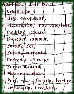
Noja, Ris beach
![]() The beach of Ris is located in the municipality of Noja, belonging to the region of Trasmiera; on the western coast of Cantabria. Its length of 2200 meters and average width of 100 meters, added up to its urban emplacement, do of it a beach with a high degree of occupation.
The beach of Ris is located in the municipality of Noja, belonging to the region of Trasmiera; on the western coast of Cantabria. Its length of 2200 meters and average width of 100 meters, added up to its urban emplacement, do of it a beach with a high degree of occupation.
This great sandbank has two differentiated parts. One of them, next to the Stuary of Quejo , it is a calm and remote zone, placed in the limit of The Marshes Joyel (one of three parts that compose the Nature reserve of Santoña’s Marshes, Victoria and Joyel) and due to this is known as Beach of Joyel. Governed by the pace of the tides, which conceals the 60% of the surface of the beach with the high tide. The other zone located opposite to Noja and delimited in its ends by rocky islands, is the urban part of Ris’s beach. The low tide discovers the sandy bottom and partially covered by rocks, the curved form of the beach and the water moving back from the shore towards the Cantabrian Sea; creating small whirlpools in the wings because of the effects of the currents.
The Beach of Ris is advisable for the leisure, the fishing and the swimming. Ideal for the practice of paddle sup, with the calm sea. To play surf in this beach produces enjoyable sessions for all the levels when the conditions are acceptable. There, The strong Sea is only suitable for experienced surfers that know well the zone and for wayfarers who want to enjoy the spectacle of the storm in this part of the Cantabrian coast.
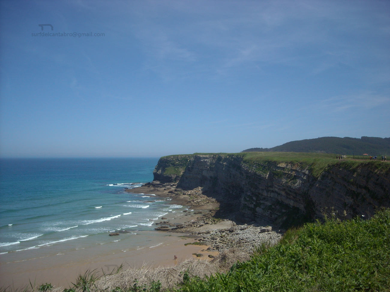
Gerra, playa
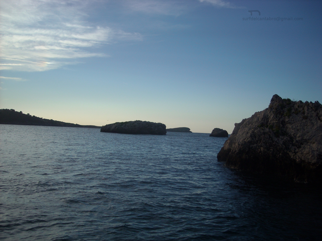
![]() La playa Gerra, también llamada El Cabo, se encuentra en el municipio de San Vicente de la Barquera; en la costa occidental de Cantabria. Situada en la cara oeste del cabo que une la costa de San Vicente de la Barquera con la costa de Oyambre, es una playa de 900 metros de longitud y una anchura media aproximada de 30 metros.
La playa Gerra, también llamada El Cabo, se encuentra en el municipio de San Vicente de la Barquera; en la costa occidental de Cantabria. Situada en la cara oeste del cabo que une la costa de San Vicente de la Barquera con la costa de Oyambre, es una playa de 900 metros de longitud y una anchura media aproximada de 30 metros.
Su escarpado acceso esconde parcialmente a Gerra y da entrada a un emplazamiento idílico con vistas panorámicas, que en los días de buena visibilidad muestran parte de la costa asturiana y Los Picos de Europa. A los pies de los acantilados y protegida por El Cabo de Oyambre, recoge los vientos de la ensenada y las corrientes de la zona. Destaca la calidad de sus aguas, limpias y trasparentes, que dejan traslucir sus fondos cerca de la orilla; sólo enturbiada por las fuertes corrientes que hay en el área y el viento, presente de manera habitual.
El emplazamiento de Gerra, entre acantilados y formaciones rocosas, hacen que su fondo arenoso se mezcle con rocas sueltas y diseminadas por todo el área. Las zonas cercanas a la orilla y próximas al pico PeñaEntera son evitables en la práctica del surf, pues además las corrientes son fuertes cerca de la pico montañoso que delimita a Gerra. Nacen las olas a 100 metros de la arena, siendo su recorrido de pequeña e «intensa» extensión. Abren sus olas a izquierdas y derechas, combandose por el trazado curvo de la playa, favoreciendo las maniobras y el viaje activo para su navegación.
Corre el aire, vuela sobre las aguas de Gerra, proporcionando energía a sus olas, moldeando sus formas. Prologando en el tiempo y en el espacio las paredes de agua que allí se forman. Si está ausente, es que ya pasó, y sobre las ondas reflejado queda su filtrado, su pulido acabado, sello característico de esta singular zona de la costa cántabra.

Gerra, beach
![]() The beach of Gerra, also called El Cabo, is in the municipality of San Vicente de la Barquera; on the western coast of Cantabria. Placed in the west side that joins the coast of San Vicente de la Barquera with Oyambre’s coast, is a beach of 900 meters of length and an average approximate width of 30 meters.
The beach of Gerra, also called El Cabo, is in the municipality of San Vicente de la Barquera; on the western coast of Cantabria. Placed in the west side that joins the coast of San Vicente de la Barquera with Oyambre’s coast, is a beach of 900 meters of length and an average approximate width of 30 meters.
Its steep access hides partially Gerra and gives entry to an idyllic emplacement with panoramic view, that in the days of good visibility show part of the Asturian coast and the massif Picos de Europa. To the feet of the cliffs and protected by Oyambre’s Cape, which gathers the winds of the inlet and the currents of the zone. Stands out the quality of its waters, clean and clear, that show its funds near the shore; only muddied by the strong currents that exist in the area and the wind, present in an habitual way.
The emplacement of Gerra, between cliffs and rocky formations, which do that its sandy bottom mixes with free and scattered rocks in all the area. The zones near to the shore and next the beak PeñaEntera are avoidable in the practice of the surf, since in addition the currents are strong near its mountainous peak that delimits Gerra. The waves are born to 100 meters of the sand, being its tour with small and intense extension. It open its waves for left and rights sides, curving because of the curved tracing of the beach, favoring the maneuvers and the active trip for its navigation.
It traverses; the air, flies on Gerra’s waters, providing energy to its waves, molding its forms. It extend, in the time and in the space, the water walls that there are formed. If it is not in, it is that already it happened, and on the waves is reflected its filtered, its polished ended, typical stamp of this singular zone of the Cantabrian coast.
Oyambre, playa
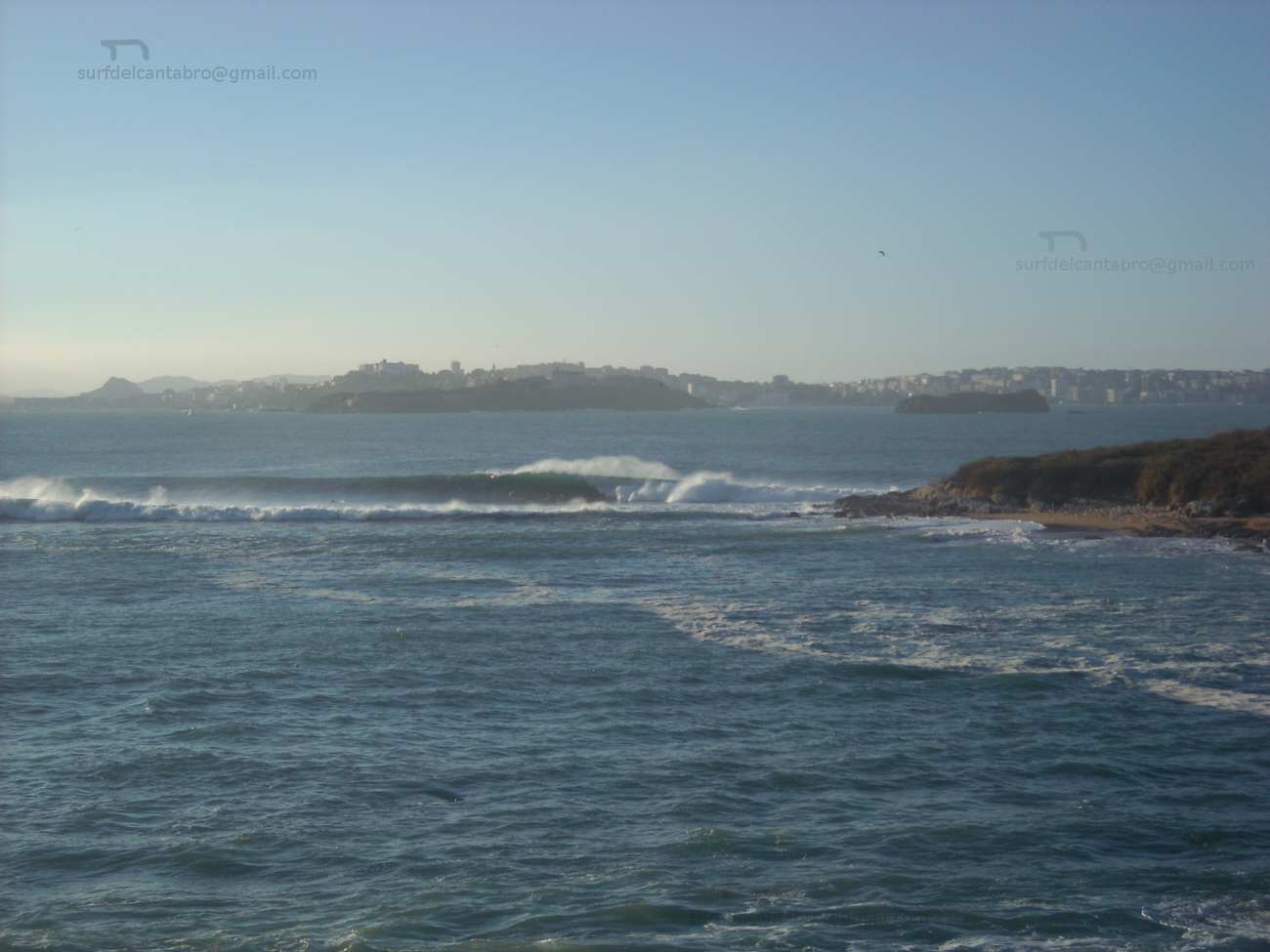
![]() La playa de Oyambre está situada en el municipio de Valdáliga, emplazado en la costa occidental de Cantabria. Situada dentro del Parque Natural de Oyambre, es un extenso arenal de 1800 metros de longitud dispuestos en linea recta y curvando su ala izquierda por la morfología de su entorno dominado por acantilados. El extremo derecho continúa a través de la costa cántabra hasta perderse en el horizonte.
La playa de Oyambre está situada en el municipio de Valdáliga, emplazado en la costa occidental de Cantabria. Situada dentro del Parque Natural de Oyambre, es un extenso arenal de 1800 metros de longitud dispuestos en linea recta y curvando su ala izquierda por la morfología de su entorno dominado por acantilados. El extremo derecho continúa a través de la costa cántabra hasta perderse en el horizonte.
La entrada a la playa se realiza a través de un pequeño aparcamiento habilitado para 50 vehículos, aproximadamente. La contemplación de Oyambre produce en el caminante una sensación acogedora e intima, que contrasta con la amplitud y enormidad del entorno. Salvaje y naturalmente dibujada, es recorrida por el viento en toda su plenitud que la visita de forma casi regular. Su extensión se plasma por medio de una llanura de arena endurecida, con una leve pendiente hasta la orilla, a modo de invitación para conocer sus aguas. La playa de oyambre, por sus características, sirvió en el siglo pasado de pista de aterrizaje del llamado «Pájaro amarillo»; primer avión que cruzó el Océano Atlántico en una travesía de 29 horas. Esto da una idea de la singularidad del lugar.
Baña el Mar la costa y la playa, ondula suavemente el fondo arenoso por los efectos de las mareas y el oleaje. Aparecen las ondas en diversos picos de olas que existen en la playa. Su forma pulida y recorrido alargado,en la zona central, se combina con áreas donde estas recorren menor extensión y favorecen las maniobras. Golpea el Mar Cantábrico al surfista, iniciando así la navegación, naciendo su viaje sobre las olas. Travesía prolongada y colmada, pues a la energía que inyecta la velocidad se suma la pureza del agua, del aire, la belleza de la costa al fondo, que por sensaciones llegan a uno mismo y terminan por prender el fuego en el interior.

Oyambre, beach
![]() The beach of Oyambre is placed in the municipality of Valdáliga, located in the western coast of Cantabria. Housed inside the Nature Reserve of Oyambre, it is an extensive sandbank of 1800 meters of length arranged on straight line; with a left wing curved because of the morphology of its environment dominated by cliffs. The right wing continues across the Cantabrian coast up to getting lost in the horizon.
The beach of Oyambre is placed in the municipality of Valdáliga, located in the western coast of Cantabria. Housed inside the Nature Reserve of Oyambre, it is an extensive sandbank of 1800 meters of length arranged on straight line; with a left wing curved because of the morphology of its environment dominated by cliffs. The right wing continues across the Cantabrian coast up to getting lost in the horizon.
The entry to the beach is realized across an small parking enabled for 50 vehicles, approximately. Oyambre’s contemplation produces in the wayfarer a cozy and intimate sensation, that contrasts with its length and enormity of its environment. Wild and naturally drawn, is crossed by the wind in all its fullness that visits it almost regularly. Its extension takes form by means of a plain of hard sand, with a slight earring up to the shore, as an invitation to know his waters. The beach of Oyambre, for its characteristics, was used int the last century as a runway of the so called yellow Bird; the first plane that crossed the Atlantic Ocean in a voyage of 29 hours. This gives an idea about the singularity of the zone.
The Sea bathes the coast and the beach, it waving softly the sandy bottom due to the effects of the tides and the surge. The waves appear in diverse beaks that exist in the beach. Its polished form and elongated tour, in the central zone, combines with areas where them are in less extension and allow the maneuvers. It strikes the Cantabrian Sea to the surfer, initiating in this way the navigation, borning his trip on the waves. Long and fulfilled voyage, because at the energy that injects the speed is added the purity of the water, of the air, the beauty of the coast in the background, which through its sensations come to oneself and them end for lighting the fire inside.