Potes, villa y capital de Liébana
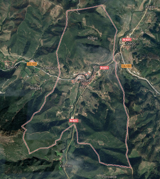
![]() Potes es una localidad situada en la región occidental de Cantabria. Emplazada en la comarca de Liébana y siendo su capital, se encuentra a 291 metros de altitud, en el corazón del Parque Nacional de Picos de Europa.
Potes es una localidad situada en la región occidental de Cantabria. Emplazada en la comarca de Liébana y siendo su capital, se encuentra a 291 metros de altitud, en el corazón del Parque Nacional de Picos de Europa.
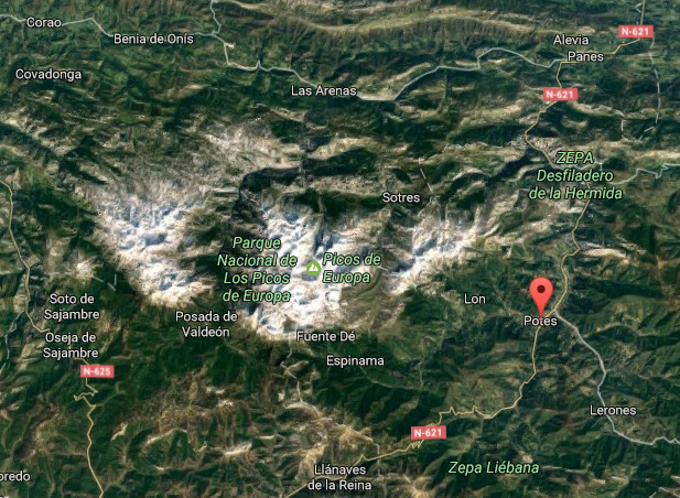
La localización única de la villa la convierte en un punto de encuentro de cuatro valles. Recibe la desembocadura del Río Quiviesa, que sirve de afluente al Río Deva el cual nace en el Macizo Cántabrico. La orografía montañosa que perfila su contorno delimita la comarca y configura un entorno natural excepcional. La existencia de valles en su interior representa diferencias de altitud y crea un microclima mediterráneo en el fondo de este gran valle que se torna atlántico a medida que ascendemos hasta los picos que alcanzan los 2000 metros.
Habitada desde tiempos prehistóricos, fue repoblada en el siglo VIII y IX durante La Reconquista. En aquella época recibió numerosa población que contribuyó a enriquecer la vida y cultura de Liébana a lo largo de la Edad Media. Destacan la Torre del Infantado, Torre del Orejón de la Lama, la Iglesia de San Vicente y el Puente de San Cayetano cómo muestras arquitectónicas de una época. La configuración de Potes, sus barrios, calles y plazas trasmiten el paso del tiempo y la historia vivida. Los barrios de la Solana y el Sol concentran numerosas edificaciones que hacen del casco histórico Bien de Interés Cultural.
Es su clima característico el que posibilita la existencia del cultivo de la vid que sirve para elaborar el orujo de Potes. Abundan las encinas y alcornoques, característicos del bosque mediterráneo, entremezclados con especies propias del bosque atlántico como el hayedo y el roble. Otras especies como tejos, alisos, acebos, avellanos, chopos … amplían la diversidad y embellecen su naturaleza.
Potes, village and capital of Liébana
![]() Potes it is a locality placed in the western region of Cantabria. Located in the region of Liébana and being its capital, it is to 291 meters of altitude, in the heart of the National Park of Picos de Europa.
Potes it is a locality placed in the western region of Cantabria. Located in the region of Liébana and being its capital, it is to 291 meters of altitude, in the heart of the National Park of Picos de Europa.
The unique location of the villa turns it into a point of meeting of four valleys. It receives the river mouth of the river Quiviesa, tributary to the Rio Deva which is born in the Cantabrian Range. The mountainous orography that outlines his contour delimits the region and forms an excepcional natural environment. The existence of valleys inside it represents differences of altitude and creates a Mediterranean microclimate at the back of this great valley that becomes Atlantic as we ascend up to the beaks that reach 2000 meters.
Populated from prehistoric times, it was repopulated in the 8th century and the IXth during The Reconquest. In that epoch Potes received numerous population who helped to enrich the life and culture of Liébana along the Middle Ages. Emphasize the Tower of the Infantado, Tower of Orejón de la Lama, San Vicente’s Church and San Cayetano’s Bridge as architectural examples of an epoch. The configuration of Potes, its neighborhoods, streets and squares transfer the passage of time and the lived history. The neighborhoods of the Solana and the Sol concentrate numerous buildings that do of the historical center an Heritage of Cultural Interest.
It is its typical climate the one that makes possible the existence of the culture of the grapevine that serves to elaborate the grape marc of Potes. The holm oaks and cork oaks abound, typical of the Mediterranean forest, intermingled with own species of the Atlantic forest as the hayedo and the oak. Other species like yews, alder-trees, hollies, hazels, black poplars … extend the diversity and embellish its nature.
![]()
 Potes, village
Liébana, natural area