Playa de La Salvé, ruta
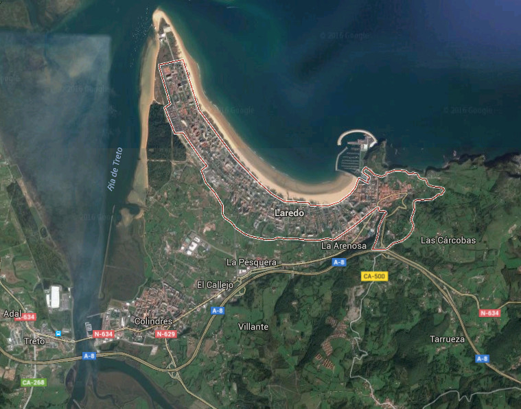
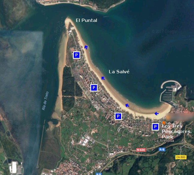
Icono Español. Icon Spanish. La Salve, ruta La playa de La Salvé, situada en Laredo, es la playa más larga de Cantabria. Su longitud de 4250 metros y anchura media de 120 metros habilitan un extenso área cuya forma curvada acota parte de la localidad y su unión con el Mar Cantábrico. El recorrido es acompañado por un Paseo Marítimo que se prolonga hasta el Puntal, lengua de arena que delimita la entrada a la Bahía de Santoña en uno de sus extremos.

Empezaremos la ruta en el Parque de los Tres Pescadores, zona ajardinada próxima al puerto deportivo y localizado en el extremo Este del recorrido. Desde allí, podemos elegir entrar al arenal o caminar por el Paseo Marítimo. El principio del recorrido posee el tramo más curvado, por lo que la aparición de edificios y dunas irán descubriendo los encantos sencillos de un simple paseo. A medida que avancemos, los pasos sobre la arena acumularán un tonificado desgaste. Es aconsejable caminar cerca de la orilla, donde la arena que abandonó el agua por las mareas permanece más dura y facilita el camino. Tras el comienzo, una recta alargada aparece. Acompañados por el sonido aleatorio y orquestral del océano conseguiremos dejar atrás el bullicio urbano. La brisa, presente en la zona, endulzará el viaje y proyectará la imaginación que el entorno disparó. Cualquier punto del recorrido es adecuado para terminar nuestro paseo, acorde a la condición física de cada uno y el tiempo disponible.

El final del trayecto hará aparecer El Puntal de Laredo. Península arenosa y dunar que sirve de bisagra a la entrada de la Bahía de Santoña. Este punto único, emplazamiento privilegiado de su entorno, proporciona una visión panorámica de un espacio singular creado por la naturaleza a través del tiempo. En ese momento es aconsejable buscar un pequeño espacio a modo de silla, reposar y degustar el final del trayecto.

Separador. DividerIcono Español-Inglés. Icon Spanish-Englishla Salvé , Trekking RouteIcono separador. Icon divider

Beach La Salvé, route

Icono Inglés. Icon English. La Salve, route The beach of La Salvé, placed in Laredo, it is the longest beach of Cantabria. Its length of 4250 meters and average width of 120 meters enable an extensively area which curled form annotates part of the locality and its union with the Cantabrian Sea. The tour is accompanied by a Maritime Promenade that prolongs up to El Puntal, language of sand that delimits the entry to Bay of Santoña in one of its ends.

We will begin the route in Los Tres Pescadores Park , landscaped zone next the yachting port and located in the East extreme of the tour. From there, we can choose enter to the sandbank or walk along the seafront. The beginning of the journey possesses the most curled section, so the appearance of buildings and dunes will discover the easier captivations of a simple walk. As we advance, the steps on the sand will accumulate a strengthened wear. It is advisable to go near the shore, where the sand that left behind the water by the tides remains harder and facilitates the way. After the beginning, an elongated straight line appears. Accompanied by the random and orquestral sound of the ocean we will manage to leave behind the urban hustle. The breeze, present in the zone, will sweeten the trip and will project the imagination that the environment shot. Any point of the tour is adapted to finish our tour, chord to the physical condition of each one and the available time.

The end of the distance will make appear El Puntal of Laredo. Sandy and dune peninsula, that runs as a hinge, at the entry of Bay of Santoña. Thisunique point, privileged emplacement of its environment, provides a panoramic vision of a singular space created by the nature across the time. In this moment it is advisable to look for an small space as a chair, to rest and to taste the end of the distance.

Icon close Sponsor

Share

Laredo, ciudad

Icono Español. Icon Spanish Laredo, ciudad y municipio de la costa oriental cántabra, cuenta con una población estacional que supera los 12.000 habitantes. Esta población multiplica por diez su número para convertirse en uno de los destinos de mayor ocupación de Cantabria.

El caso antiguo de la villa hunde sus orígenes en el tiempo con los primeros pueblos que poblaron la zona y es en el siglo VIII cuando aparece la primer referencia escrita. Destacan sus monumentos, historia, su oferta turística y gastronómica. La Batalla de las Flores, fiesta declarada de interés turístico nacional, se celebra el último viernes de Agosto y constituye una expresión folclórica donde sus vecinos expresan su arte por medio de carrozas florales.

La configuración de la ciudad descansa sobre montes y montañas, para extenderse hasta el mar cubriendo la zona y poblando una punta de arena gigantesca cuyos arenales superan los 8 kilómetros de longitud. El nuevo puerto deportivo acota el arenal en su margen derecho. El Puntal, acota la villa en su extremo occidental que delimita con la de Ría de Treto.

Laredo, city

Icono Inglés. Icon English Laredo, city and municipality of the oriental coast of Cantabria, possesses a population that overcomes 12.000 inhabitants. This population multiplies by ten its number to turn it into one of the destinations of major occupation of Cantabria.

The historic center of the villa sinks its origins in the time with the first peoples that populated the zone and is in the 8th century when the first written reference appears. Stand out the monuments, history, its tourist and gastronomic offer. The Battle of the Flowers, a holiday that have been declared of tourist national interest, is celebrated the last Friday of August and constitutes an expression folclórica where the neighbors express his art by means of floral floats.

The configuration of the city rests on mounts and mountains, to spread up to the Sea covering the zone and populating a gigantic tip of sand which sandbanks overcome 8 kilometres of length. The new sports port annotates the sandbank in its right margin. The Puntal, a strut zone, annotates the villa in its western end that it delimits with the Estuary of Treto.

Icon text divider

Laredo,  route

Icono español-inglés. Icon Spanish-English. Laredo Laredo, ciudad


Laredo, Ciudad

icon close cities

Share

La Salvé, playa

Icono Español. Icon Spanish. La Salve, playa La playa de La Salvé se encuentra en el municipio de Laredo, ubicado en la costa oriental de Cantabria. Es un extenso arenal de más de cuatro kilómetros de longitud y anchura media aproximada de 140 metros. Jalonada por un paseo marítimo a lo largo de su recorrido que la presenta y permite al caminante disponer de una posición privilegiada para su contemplación.

Empezando el paseo en el extremo derecho, próximo al puerto deportivo, avanzan los pasos a través de la media luna que dibuja este allí. Caminando, podemos disfrutar de la villa a mano izquierda y del Mar a mano derecha. Varias entradas al arenal aparecen al encuentro para, una vez atraídos, acceder a la playa. Pasado el pequeño sistema dunar cercano al paseo, asoma un llanura que se extiende por debajo de sus aguas, pues La Salvé recuerda a una playa de otros mares. Para alcanzar profundidad, debemos recorrer una extensión mayor que en el resto de playas cántabras.

Debido a las características de la playa, la presencia de olas no es regular. Los tamaños medios ó bajos de las ondas se ven incrementados cuando arrecia temporal, abriendo numerosos picos de olas a lo largo de La Salvé, que se suceden a izquierdas y derechas. Su configuración y parámetros, la convierten en una zona ideal para practicar sky-surf y paddle-surf, wind-surf. El otoño e invierno traen a Laredo los mejores momentos de surf, que ayudados con la gran extensión y fisionomía de la zona, ofrecen a los surfistas un circuito con variedad cuantitativa y cualitativa.

Cabecera Cities Place Beaches. La Salve, playa
La Salve, Notas

The Salvé, beach

Icono Inglés. Icon English. The Salvé, beach The beach of The Salvé is in the municipality of Laredo, located in the oriental coast of Cantabria. It is an extensive sandbank with more than four kilometres of length and average approximate width of 140 meters. Marked by a maritime walk along its tour that presents it and allows to the wayfarer to have a position favoured for the contemplation.

Beginning the walk in the right wing, next the sports port, the steps advance across the half moon that draws this one, there. Walking, we can enjoy the villa to the left hand and the Sea to the right hand. Several points to income to the sandbank appear to the meeting for; once attracted, accede to the beach. Then the small dune system near the promenade, it puts out a llanura that spreads below his waters, because The Salvé resembles a beach of other seas. To reach depth, we must cross a major extension than the rest of Cantabrian beaches.

Due to the characteristics of the beach, the presence of waves is not regular. The average sizes or low of the waves are increased when storms arrive, opening numerous beaks of waves along The Salvé, that open to the left and right sides. Its configuration and parameters, turn it into an ideal zone to practise sky-surf, paddle-surf and windsurfing. The autumn and winter bring to Laredo the best moments of surf, which helped with the great extension and physiognomy of the zone, offer a circuit to the surfers with quantitative and qualitative variety.

Cabecera Cities Place Beaches. The Salve, beach
La Salve, Notes

Share

Playa de San Julián, acceso

Icono Español. Icon Spanish. Playa de San Julián La Playa de San Julián está situada en el municipio de Liendo. Es una pequeña cala emplazada en un entorno idílico y ubicada entre las localidades de Laredo y Oriñón, en la costa oriental de Cantabria. La llegada a la playa atraviesa las localidades de Iseca Vieja y Villanueva, después de abandonar la autovía. Dispone de un pequeño aparcamiento en el sendero que conduce hasta la arena.

San Julián Beach, access

Icono Inglés. Icon English. Playa de San Julián The Beach of San Julián is placed in the municipality of Liendo. It is a small cove located in an idyllic environment and deployed between the localities of Laredo and Oriñón, on the oriental coast of Cantabria. The arrival to the beach crosses the localities of Iseca Vieja and Villanueva, after leaving the motorway. It has a small parking in the path that leads up to the sand.

Icono español-inglés. Icon Spanish-English. Playa de San Julián Acceso/Access

Access San Julián Beach

Icon close Sponsor

Share

Playa de San Julián, localización

Icono. Icon La playa de San Julián es un pequeña cala situada en el municipio de Liendo. El viaje transcurre por autovía y finaliza en la carretera nacional N-634. El trayecto termina atravesando las localidades de Iseca Vieja y Villanueva, se llega a la playa. Se muestran a continuación como puntos de partida Oviedo, Palencia, Santander y Bilbao.

Beach of San Julián, localization

Icono. Icon The beach of San Julián is an small cove placed in the municipality of Liendo. The travel runs by motorway and it finishes in the national road N-634. Crossing the localities of Iseca Vieja and Villanueva, you come to the beach. Shown below as starting points Oviedo, Palencia, Santander and Bilbao.

Icono español-inglés. Icon Spanish-English Localización/Localization

Oviedo, San Julián : LocalizationPalencia, San Julián : localizationBilbao, San Julián : localizationSantander, San Julián : localization

Icon close Sponsor

Share

Playa Arenal de Sonabia, acceso

Icono. Icon La playa Arenal de Sonabia está situada en la localidad costera de Sonabia. Perteneciente al municipio de Liendo, se ubica entre Laredo y Oriñón, en la costa oriental de Cantabria. Desde el pueblo se accede directamente a la playa. El final de esa misma carretera se usa a modo de aparcamiento.

Beach Sandbank of Sonabia, access

Icono. Icon The beach Sandbank of Sonabia is placed in coastal locality of Sonabia. Belonging to the municipality of Liendo, it is located between Laredo and Oriñón, on the oriental coast of Cantabria. From the town you access directly to the beach. The end of the same road is used like parking.

Icono español-inglés. Icon Spanish-English Acceso/Access

Access Arenal de Sonabia

Icon close Sponsor

Share

Playa Arenal de Sonabia, localización

Icono. Icon. Arenal de Sonabia La playa Arenal de Sonabia es un cala situada en la localidad de Sonabia, perteneciente al municipio de Liendo. El viaje transcurre por autovía y finaliza en la carretera nacional que atraviesa Oriñón, hasta llegar a Sonabia y su playa. Veremos el acceso al arenal antes de finalizar la ruta. Se muestran a continuación como puntos de partida Oviedo, Palencia, Santander y Bilbao.

Beach Sandbank of Sonabia, localization

Icono. Icon. Sonabia, sandbank The beach, Sandbank of Sonabia, is a cove placed in the locality of Sonabia, belonging to the municipality of Liendo. The travel passes for motorway and finishes in the national road that crosses Oriñón, up to coming to Sonabia and its beach.We will see the access to the beach before finishing the route. Shown below as starting points Oviedo, Palencia, Santander and Bilbao.

Icono español-inglés. Icon Spanish-English. Arenal de Sonabia, sandbank Localización/Localization

Oviedo, Arenal de Sonabia : LocalizationPalencia, Arenal de Sonabia : localizationBilbao, Arenal de Sonabia : localizationSantander, Arenal de Sonabia : localization

Icon close Sponsor

Share

Playa de Brazomar, acceso

Icono Español. Icon Spanish. Brazomar, acceso La playa de Brazomar se encuentra en Castro Urdiales, ciudad costera situada en la parte oriental de Cantabria. Una vez en la localidad la llegada hasta la playa está bien indicada. Tiene varios accesos y zonas de aparcamiento.

Brazomar beach, access

Icono Inglés. Icon English. Brazomar, access Brazomar beach is placed in Castro Urdiales, coastal city placed in the oriental part of Cantabria. Once in the locality, the arrival to the beach is well done. It has several accesses and zones of parking.

Icono Español-Inglés. Icon Spanish-English. Brazomar, acceso/access Acceso/Access

Brazomar beach, access

Icon close Sponsor

Share

Brazomar, localización

Icono Español. Icon Spanish La playa de Brazomar se encuentra en Castro Urdiales, ciudad y municipio costero ubicado en la parte oriental de Cantabria. Cuenta con un entorno montañoso y marítimo, situado entre las ciudades de Laredo y Bilbao. El trayecto hacia la playa finaliza dentro de la ciudad, desde donde se accede directamente al arenal. El viaje se realiza por autovía, indicando como puntos de partida : Oviedo, Palencia, Santander y Bilbao.

Beach of Brazomar, localization

Icono Inglés. Icon English The beach of Brazomar is in placed Castro Urdiales, coastal city and municipality located in the oriental part of Cantabria. It possesses a mountainous and maritime environment placed between the cities of Laredo and Bilbao. The travel towards the beach finishes inside the city, from where one accedes directly to the sand. The trip is realized by highway. Shown below as starting points: Oviedo, Palencia, Santander and Bilbao.

Icono Español-Inglés. Icon Spanish-English Localización/Localization

Oviedo, Brazomar: LocalizationPalencia, Brazomar: localizationBilbao, Brazomar: LocalizationSantander, Brazomar: Localization

Icon close Sponsor

Share

Playa de Arenillas, Islares. Acceso

Icono Español. Icon Spanish. Playa de Arenillas La playa de Arenillas está situada en el pueblo de Islares. Esta localidad se encuentra emplazada entre montaña y mar, ubicada entre Laredo, Oriñón y Castro Urdiales; en la costa oriental de Cantabria. La llegada a la playa atraviesa la localidad. Tiene un único acceso que cuenta con una pequeña zona de aparcamiento.

Beach of Arenillas, Islares. Access

Icono Inglés. Icon English. Beach of Arenillas The beach of Arenillas is placed in the town of Islares. This locality has grown between mountain and sea, located between Laredo, Oriñón and Castro Urdiales; on the oriental coast of Cantabria. The arrival to the beach runs through the locality. It has one access that possesses a small zone of parking.

Icono Español-Inglés. Icon Spanish-English Acceso/Access

Playa de Arenillas, Islares, acceso. Beach of Arenillas, Islares, access

Icon close Sponsor

Share