Pechón, villa

Icono Español. Icon Spanish. Pechón, villa, village Pechón es una localidad situada en el extremo occidental de Cantabria, perteneciente al municipio de Val de San Vicente. El característico emplazamiento y singular entorno que dispone la villa lo convierten en un destino único, cuya oferta de ocio cuenta con una variada gama de opciones.

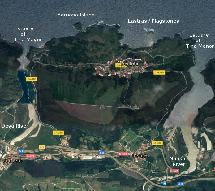
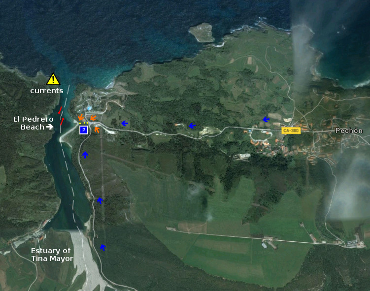
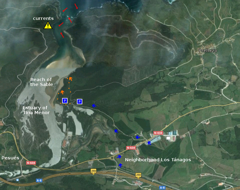
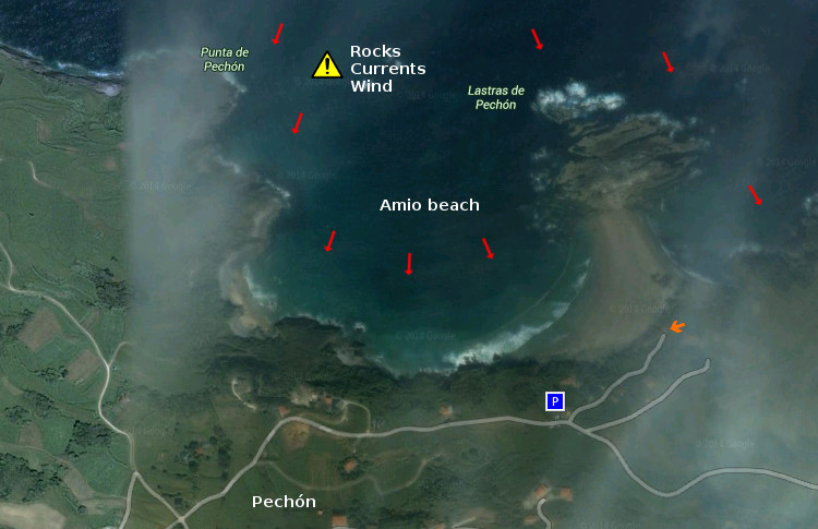
Dos estuarios delimitan y configuran la península sobre la que se establece Pechón. La Ría de Tina Mayor, en el extremo Oeste, compartida con Asturias y establecida sobre una plataforma de erosión que recibe la desembocadura del Río Deva. La Ría de Tina Menor se encuentra en la desembocadura del Río Nansa y se asienta sobre otra plataforma de abrasión que se escalona con la anterior y acota el extremo Este. Al frente, el Mar Cantábrico baña el litoral, recorriendo lastras, islas y acantilados. La línea de costa, de forma irregular, recibe el oleaje desde tiempos remotos reflejando en su trazado el arte que el Mar y el Tiempo proponen.

El destino allí comenzará con una ascensión hasta el núcleo de población. Flanqueada la travesía con sendos ríos, es acompañado con rocas y praderas más adelante. Rincones bonitos, prados de verde intenso, la abundancia de rocas que conforman sus paisajes y varios miradores potenciarán las sensaciones que registrarán un dulce recuerdo a la partida.

Icono Inglés. Icon English. Pechón, villa, village Pechón is a locality placed in the Western end of Cantabria, belonging to the municipality of Val de San Vicente. The characteristic emplacement and singular environment that provides the village, turn it into the unique destination which leisure possesses a varied range of options.

Two estuaries delimit and form the peninsula on which Pechón is established. The Estuary of Tina Mayor, in the West extreme, shared with Asturias and established on a platform of erosion that receives the river mouth of the River Deva. The Estuary of Tina Menor finds in the river mouth of the River Nansa and lives on another platform of erosion that is staggered from the previous one and encloses the East extreme. To the front, the Cantabrian Sea laps the littoral, crossing flagstones, islands and cliffs. The line of coast, with irregular form, receives the surge from remote times reflecting in its tracing the art that the Sea and the Time propose.

The destination there will begin with an ascension up to the center of population. Flanked the voyage with each river mouth, it is accompanied with rocks and fields, hereinafter. Nice corners, meadows of intense green, the abundance of rocks that its landscapes shape and several viewing-points will promote the sensations that will register a sweet recollection to the leaving.

 Pechón, villa, village. Icon text divider

Pechón, routes

Icono español-inglés. Icon Spanish-English. Pechón, villa, village. Map Pechón, village

Pechón, map

 Pechón, villa, village. icon close cities

Share

EL Pedrero, playa

Icono Español. Icon Spanish. El Pedrero, playa La playa El Pedrero está situada en la localidad de Pechón, perteneciente al municipio de Val de San Vicente. Emplazada en la desembocadura de la Ría de Tina Mayor, es la playa más occidental de Cantabria.

Este pequeño arenal, compuesto por arena blanca y grava, tiene una longitud de 200 metros y anchura media de 10 metros. Sus dimensiones, cambiantes por efecto de las mareas, acotan una plataforma desde donde contemplar la excepcional belleza del lugar. El final del estuario, desembocadura del Río Deva, se reúne con el Mar Cantábrico; que expresa su naturaleza y fuerza en toda la línea de costa del municipio cántabro.

El entorno de media montaña en el que existe la playa dispone un idílico ambiente. Árboles, rocas y mar, armonizados por el sonido del agua en su movimiento.

Cabecera Cities Place Beaches . El Pedrero, playa
El Pedrero, notas

El Pedrero, beach

Icono Inglés. Icon English. El Pedrero, beach The beach El Pedrero is placed in the locality of Pechón, belonging to the municipality of Val de San Vicente. Located in the Tidal River of Tina Mayor, it is the most western beach of Cantabria.

This small sandbank composed by white sand and loose stones, has a length of 200 meters and an average width of 10 meters. Its dimensions, changeable for effect of the tides, draw a platform from where contemplating the exceptional local beauty. The end of the estuary, river mouth of the Deva River, meets the Cantabrian Sea; that expresses its nature and force in the whole line of coast of the Cantabrian municipality.

The environment with medium-sized mountains in which the beach exists arranges an idyllic natural surroundings. Trees, rocks and sea harmonized by the sound of the water in its movement.

Cabecera Cities Place Beaches. El Pedrero, beach
El Pedrero, notes

Share

EL Sable, playa

Icono Español. Icon Spanish. El Sable, playa El Sable es una playa situada en la localidad de Prellezo, perteneciente al municipio de Val de San Vicente. Emplazada en el interior de la Ría de Tina Menor, su fisonomía está determinada por el trasiego de las mareas y la configuración del estuario.

El Sable, playa de 350 metros de longitud y apenas 10 metros de anchura media, es un pequeño y particular arenal. Localizada entre la desembocadura del Río Nansa y el cierre de la Ría de Tina Menor, disponen de aguas tranquilas y protegidas de mar abierto. Su entorno natural y salvaje se encuentra poblado de bosque atravesado por senderos. El lado derecho de la ría que ocupa la playa es transitable en marea baja hasta su final y al encuentro con el mar. La tranquilidad natural que reina en la zona convierten la estancia en un reconstituyente descanso.

El otoño trae consigo las grandes mareas, removiendo el fondo de arena y arcilla. Tiñe la zona de color beige y deposita nuevos sedimentos que alimentan la diversidad biológica presente. La primavera hace regresar las aves y completa un sistema que puede ser disfrutado desde la playa de El Sable.

Cabecera Cities Place Beaches . El Sable, playa
El Sable, notas

El Sable, beach

Icono Inglés. Icon English. El Sable, beach El Sable is a beach placed in the locality of Prellezo, belonging to the municipality of Val de San Vicente. Located inside the Estuary of Tina Menor, its physiognomy is determined by the decanting of the tides and the configuration of the tidal river.

El Sable, beach of 350 meters of length and just 10 meters of average width, is an small and particular sandbank. Located between the river mouth of the Nansa River and the closing of Tina Menor, it has calm waters and protected from open sea. Its natural and wild environment is populated of forest crossed by paths. The right side of sea inlet that occupies the beach, it is pasable in low tide until its end and to the meeting with the sea. The natural tranquility that reigns in the zone, turns the stay into a restorative rest.

The autumn brings with it the big tides, removing the bottom of sand and clay. It dyes the zone of beige color and new sediments are despositated that feed the present biological diversity. The spring makes return the birds and completes a system that can be enjoyed from the beach of El Sable.

Cabecera Cities Place Beaches. El Sable, beach
El Sable, notes

Share

Amio, playa

Icono Español. Icon Spanish. Amio, playa La playa de Amió está situada en la localidad de Pechón, perteneciente al municipio de Val de San Vicente. Situada entre las rías de Tina Mayor y Tina menor es una de las playas más occidentales de Cantabria. Emplazada a apenas unos kilómetros de Asturias, disfruta del Mar Cantábrico que recibe en estado natural.

La fisonomía de su arenal , con 700 metros de longitud, une las Lastras de Pechón a la costa. El lado izquierdo de la playa está acotado por la Punta de Pechón que esculpida por el efecto de la fuerza del mar, conforma una amplia e idílica ensenada. La marea baja redimensiona la playa descubriendo un pequeño paseo jalonado por rocas y formaciones geológicas . La marea alta oculta a Amió en su 80% y aumenta la riqueza de sus fondos marinos. Dualidad perpetua que la Luna trae consigo y que hace brillar a Amió con especial luz.

La presencia de corrientes y la fuerza del mar aconsejan extremar la precaución en la practica de deportes acuáticos. Las fuertes condiciones, abundancia de rocas y la falta de trazabilidad en su oleaje la convierten en una zona no apta para practicar surf. Destacan la pesca deportiva y el submarinismo.

El empinado acceso a Amió dificulta la entrada a la playa y ofrece una panorámica del lugar desde donde poder disfrutar de la inmensidad del océano reflejada en un punto, en un instante.

Cabecera Cities Place Beaches . Amio, playa
Amio, playa . Notas

Amio, beach

Icono Inglés. Icon English. Amió, beach The beach of Amió is placed in the locality of Pechón, belonging to the municipality of Val de San Vicente. Placed between the stuaries of Tina Mayor and Tina Menor is one of the most western beaches of Cantabria. Located to scarcely a few kilometres of Asturias, it enjoys the Cantabrian Sea that receives in natural condition.

The physiognomy of its sandbank, with 700 meters of length, joins the Lastras of Pechón to the coast. The left side of the beach is delimited by the Tip of Pechón that, carved for the effect of the sea force, shapes a wide and idyllic inlet. The low tide redraws the beach discovering an small area marked by rocks and geological formations. The high tide conceals Amió in its 80 % and increases the wealth of its sea beds. Perpetual duality that the Moon brings with it and that makes shine to Amió with special light.

The presence of currents, and the force of the sea advise us to carry to extremes the caution in the practice of aquatic sports. The strong conditions and abundance of rocks, and the lack of traceability in its surge turn it into a not suitable zone to practise surf. The sport fishing and the scuba diving stand out.

The steep access to Amió complicates the access to the beach and offers a panoramic view of the place from where being able to enjoy the immensity of the ocean reflected in a point, in an instant.

Cabecera Cities Place Beaches. Amio playa
Amio playa . Notes

Share

Playa El Pedrero, acceso

Icono Español. Icon Sapnish. La Playa del Pedrero está situada en la localidad de Pechón, perteneciente al municipio de Val de san Vicente. Es la playa más occidental de Cantabria. Ubicada en la desembocadura de la Ría de Tina Mayor, es apta para el baño y el ocio. Es una zona con presencia de corrientes. Existe un pequeño aparcamiento desde el cual se llega a una pequeña senda, con escaleras, que conducen directamente a la playa.

El Pedrero Beach, access

Icono Inglés. Icon English. The Beach of El Pedrero is placed in the locality of Pechón, belonging to the municipality of Val de san Vicente . It is the most western beach of Cantabria. Located in the river mouth of the Estuary of Tina Mayor , it is suitable for the swiming and the leisure. It is a zone with currents . There exists an small parking from which you will arrive to one way, with stairs, which lead directly to the beach.

Icono español-inglés. Icon Spanish-English. Acceso/Access

El Pedrero: access

Share

Playa El Pedrero, localización

Icono Español. Icon Spanish La playa El Pedrero se encuentra en la localidad de Pechón, perteneciente al municipio de Val de San Vicente; en la costa occidental de Cantabria. La ruta oficial termina en el pueblo de Pechón. Desde allí nos encaminamos por la carretera nacional CA-380 hacia el Camping, situado a la entrada de la playa. Para los viajes cuyo origen sea en el oeste, Oviedo, el Camping y la playa aparecerán antes del final del trayecto y del centro de la localidad. Se muestran a continuación como puntos de partida: Oviedo, Palencia, Santander y Bilbao. Comenzando el viaje por autovía y finalizando el recorrido por la misma carretera nacional en todos los trayectos.

Beach El Pedrero, localization

Icono Inglés. Icon English The beach of El Pedrero is in the locality of Pechón, belonging to the municipality of Val de San Vicente; on the western coast of Cantabria. The route finishes in the town of Pechón. From there, we have to go for the national road CA-380 towards the Camping; which is placed to the entry of the beach. For the travels which origin is in the west, Oviedo, the Camping and the beach will appear before the end of the tour and of the center of the locality. Shown below as starting points: Oviedo , Palencia , Santander and Bilbao . Beginning the trip for motorway and finishing the tour for the same national road in all the options.

Icono Español-Inglés. Icon Spanish-English Localización/Localization

Oviedo, El Pedrero: LocalizationPalencia, EL Pedrero: LocalizationBilbao,El Pedrero : LocalizationSantander, El Pedrero: Localization

Share

Playa del Sable, acceso

Icono Español. Icon Sapnish. La Playa del Sable está situada en la localidad de Prellezo, perteneciente al municipio de Val de san Vicente. Esta playa se ubica en la costa occidental de Cantabria, dentro de la Ría de Tina Menor. Apta para el baño y el disfrute de la naturaleza. Al norte de la playa, a 600 metros aproximadamente, confluyen el Mar y la entrada a la Ría. Allí las corrientes son más fuertes. Cuenta con dos accesos directos a la playa y pequeñas zonas utilizas a modo de aparcamiento, a 300 metros del arenal.

Beach of the Sable, access

Icono Inglés. Icon English. The Beach of the Sable is placed in the locality of Prellezo, belonging to the municipality of Val de San Vicente. This beach is located on the western coast of Cantabria, inside the Estuary of Tina Menor. Suitable for the swiming and the enjoyment of the nature. To the north of the beach, to 600 meters approximately, the Sea and the entry of the Estuary meet together. There, the currents are stronger. It possesses two direct accesses to the beach and small zones that you can use like parking, to 300 meters of the sandbank.

Icono español-inglés. Icon Spanish-English. Acceso/Access

Playa del Sable: access

Share

Playa del Sable, localización

Icono Español. Icon Spanish La Playa del Sable se encuentra en la localidad de Prellezo, perteneciente al municipio de Val de San Vicente; en la costa occidental de Cantabria. Debido a que esta zona no aparece en las guías oficiales, La ruta finaliza a unos metros de la carretera que conduce a la playa. Después de atravesar la rotonda, la segunda salida a la izquierda de la carretera, nos lleva hasta el arenal. Se muestran a continuación como puntos de partida: Oviedo, Palencia, Santander y Bilbao. Comenzando el viaje por autovía y finalizando el recorrido por la misma carretera nacional en todos los trayectos.

Beach of the Sable, localization

Icono Inglés. Icon English The Beach of the Sable is in the locality of Prellezo, belonging to the municipality of Val de San Vicente; on the western coast of Cantabria. Due to this zone does not appear in the official guides, the route finishes to a few meters of the road that leads to the beach. After crossing the roundabout, the second exit to the left of the road, will takes us up to the sandbank. Shown below as starting points: Oviedo , Palencia , Santander and Bilbao . Beginning the trip for motorway and finishing the tour for the same national road in all the options.

Icono Español-Inglés. Icon Spanish-English Localización/Localization

Oviedo, Beach of the Sable: LocalizationPalencia, Beach of the Sable: localizationBilbao, Beach of the Sable: localizationSantander, Beach of the Sable: localization

Share

Playa de Amió, acceso

Icono Español. Icon Spanish. Playa de Amió, La playa de Amió está situada en la localidad de Pechón en el municipio de Val de San Vicente, en la costa occidental de Cantabria. Es una playa pequeña, ubicada entre acantilados y lastras; que la dan forma de ensenada. El acceso desde el reducido aparcamiento, cercano a la entrada del arenal, se hace por medio de una estrecha y empinada cuesta. El fondo rocoso, las corrientes y el viento presente en la zona la convierten en una playa ideal para el baño, la pesca y el submarinismo; tomando las debidas precauciones.

Amió Beach, access

Icono Inglés. Icon English. Playa de Amió, The Amió’s beach is placed in the locality of Pechón, which is in the municipality of Val de San Vicente, in the western coast of Cantabria . It is a small beach located between cliffs and flagstones; that give it form of inlet. The access from the limited parking, nearby at the entry of the sandbank, is done through a narrow and steep slope. The rocky bottom, the currents and the present wind in the zone turn it into an ideal beach for the swiming, the fishing and the scuba diving; taking the due precautions.

Icono español-inglés. Icon Spanish-English. Playa de Amió, Acceso/Access

Amió beach: access

Icon close Sponsor

Share

Playa de Amió, localización

Icono Español. Icon Spanish La playa de Amió está situada en la localidad de Pechón, perteneciente al municipio de Val de San Vicente. El viaje se realiza por autovía y finaliza por carretera nacional. Se muestran a continuación como puntos de partida Oviedo, Palencia, Santander y Bilbao.

Covachos Beach, localization

Icono Inglés. Icon English The beach of Amió is placed in the locality of Pechón, belonging to the municipality of Val de San Vicente. The trip is realized by motorway and finishes by national road. Shown below as starting points Oviedo, Palencia, Santander and Bilbao.

Icono español-inglés. Icon Spanish-English Localización/Localization

Oviedo,  Playa de Amió: LocalizationPalencia,  Playa de Amió: localizationBilbao,  Playa de Amió: localizationSantander, Amió: localization

Share