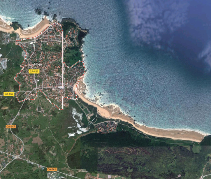
Noja, ciudad

Icono Español. Icon Spanish. Noja, city Noja, singular municipio de la costa oriental de Cantabria, es una villa cuya organización se articula en barrios. Delimitado en el oeste por la Playa de los Barcos, en el este está acotada por el Monte EL Brusco, que da nombre a la playa que se sitúa en sus accesos.

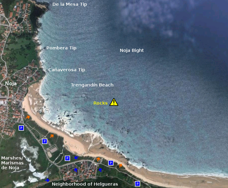
Su costa rocosa e irregular supera los 15 kilómetros de longitud y cuenta con varios arenales de fina y blanca arena. Las playas de los Barcos, Ris, Trengandín y el Brusco ocupan el 70% de la línea de costa. Variedad ofrece al visitante un amplio abanico de opciones donde practicar el baño y disfrutar del descanso. El surf, la pesca, el submarinismo y demás deportes acuáticos pueden ser disfrutados en sus arenales. La orografía de la cara Este de la villa contiene la Ensenada de Noja. Las talladas rocas que pueblan la bahía asoman sus afiladas cimas sobre las aguas del Mar Cantábrico y proporcionan un espectáculo de belleza onírica con la marea baja.

Las Marismas De Victoria y Joyel, rodean el municipio y componen, junto con las Marismas de Santoña, el mayor humedal de la cornisa cantábrica. Ambos estuarios disponen de observatorios para aves y senderos que los rodean y/o atraviesan, ofreciendo distintas perspectivas del parque natural que forman. Estos tesoros que forman parte del patrimonio de Noja pueden anticipar la inmensidad de la zona que será descubierta con cada paso, en cada rincón.

Noja, city

Icono Inglés. Icon English. Noja, city Noja, singular municipality of the oriental coast of Cantabria, is a villa which organization is articulated in neighborhoods. Delimited in the west for the Beach of Los Barcos, in the East there is annotated by the Mount El Brusco, which gives name to the beach that places in its accesses.

Its rocky and irregular coast overcomes 15 kilometres of length and possesses several sandbanks of thin and white sand. The beaches of Los Barcos, Ris, Trengandín and El Brusco occupy 70 % of the line of coast. Variety that offers a widely range of options to the visitor where to practise the swimming and enjoy the relaxation. The Surf, the fishing, the scuba diving and other aquatic sports can be enjoyed in its sandbanks. The orography of the west face of the villa contains the Inlet of Noja. The chiseled rocks that populate the bay put its sharp tops over the waters of the Cantabrian Sea and provide a spectacle of oneiric beauty in the low tide.

The Marshes of Victoria and Joyel, surround the municipality and compose, with Santoña’s Marshes, the major wetland of the Cantabrian cornice. Both estuaries have observatories for birds and paths that surround and / or cross them, offering different perspectives of the nature reserve that form. These exchequers that form a part of Noja’s heritage can anticipate the immensity of the zone that will be discovered by every step, in every corner.

Icon text divider

Noja, city. Route

Icono español-inglés. Icon Spanish-English. Noja, city Noja, ciudad

Noja, City

icon close cities

Share

Trengandín, playa

Icono Español. Icon Spanish. Trengandín, playa La playa de Trengandín está ubicada en el municipio de Noja, en la costa oriental de Cantabria. Es uno de los arenales más extensos de la costa cántabra con una longitud de 6000 metros y una anchura media aproximada de 100 metros. Debido a sus dimensiones, contiene varias zonas diferenciadas.

La primera parte de la playa, situada de zona urbana de la villa, tiene forma curva e irregular. Sus aguas repletas de afiladas rocas forman un espectacular paisaje en marea baja. Es una área adecuada para el ocio, baño, submarinismo, no siendo apta para practicar surf, pues las formaciones rocosas inundan la zona y sobresalen por encima del agua. El siguiente tramo que comienza en el Barrio de Helgueras y corre paralelo a los Montes de Mijedo, recibe el nombre de playa de Helgueras. Ocupada hasta la mitad del recorrido por rocas que van desapareciendo hasta encontrar la otra mitad libre y limpia de obstáculos para la práctica del surf. Su parte final, próxima al Monte EL Brusco, es conocida como El Brusco.

El Mar Cantábrico ingresa en la Ensenada de Noja superando la Punta de la Mesa, filtrando el oleaje, que se proyecta hacia la línea de costa. Recibe Helgueras olas que abren a izquierdas, con tamaño medio-alto, y alcanzan largo recorrido. El otoño, que registra mareas grandes, propicia olas de mayor tamaño. Desplazando las masas de agua sobre la ensenada, con suave pendiente y altura superior a los tres metros, aparecen tubos y navegaciones prolongadas. Existen otros picos de olas en la zona que abren a ambos lados y favorecen las maniobras.

Cabecera Cities Place Beaches. Trengandín, playa
Trengandin, playa. Notas

Trengandín, beach

Icono Inglés. Icon English. Trengandín, beach The beach of Trengandín is located in the municipality of Noja, on the oriental coast of Cantabria. It is one of the most extensive sandbanks of the Cantabrian coast with a length of 6000 meters and an average approximate width of 100 meters. Due to its dimensions, it contains several differentiated zones.

The first part of the beach, placed on urban zone of the villa, has a curved and irregular form. Its waters replete with sharp rocks form an spectacular landscape in low tide. It is an area adapted for the leisure, swimming, scuba diving, not being suitable to practise surf, since the rocky formations flood the zone and stand out over the water. The following section that begins in the Neighborhood of Helgueras and runs parallel to the Mounts of Mijedo, receives the Helgueras’s beach name. Occupied up to the half of the tour by rocks that disappear up to finding the second free and clean area of obstacles for the practice of the surf. Its final part, next the Mount El Brusco, is known as El Brusco.

The Cantabrian Sea enters in the Inlet of Noja overcoming the Mesa Tip, filtering the surge, which is projected towards the line of coast. Helgueras receives waves that open to left side, with medium-high size, and reach crossed length. The autumn, which registers big tides, propitiates waves of major size. The movement of the water masses in the inlet, with soft earring and height superior to three meters, brings up pipes and long navigations. Other beaks of waves exist in the zone that open for both sides and propitiates the maneuvers.

Cabecera Cities Place Beaches. Trengandín, beach
Trengandin, beach. Notes

Share

Playa de Trengandín, acceso

Icono Español. Icon Spanish. Playa de Trengandín La playa de Trengandín está situada en la Villa de Noja. Ubicada entre Santoña e Isla, en la costa oriental de Cantabria. Con una extensión mayor de seis kilómetros, cuenta con numerosas zonas de aparcamiento que dan acceso directo a la playa. Presenta una agrupación de rocas en su parte central, siendo peligrosa la practica del surf en la zona.

Tregandín beach, access

Icono Inglés. Icon English. Playa de Trengandín Trengandín beach is placed in the Villa of Noja. Located between Santoña and Isla, in the oriental coast of Cantabria. With a major extension of over six kilometres, it has on numerous zones of parking that give direct access to the beach. There are a group of rocks in its central part, being dangerous the practice of the surf in the zone.

Icono español-inglés. Icon Spanish-English. Playa de Trengandín Acceso/Access

Access: playa de Trengandín

Icon close Sponsor

Share