De Liencres hacia Robayera, ruta de senderismo
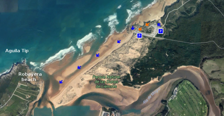
![]() La playa de Liencres, también conocida como Valdearenas, está situada en la costa central de Cantabria. Localizada al Oeste de Santander, es un extenso arenal de 2800 metros de longitud. Contando con dos amplias zonas de aparcamiento, el primero de ellos está emplazado a la entrada de la playa. El segundo parking se sitúa a la derecha del acantilado que separa el arenal grande de la otra playa de Liencres, Canallave.
La playa de Liencres, también conocida como Valdearenas, está situada en la costa central de Cantabria. Localizada al Oeste de Santander, es un extenso arenal de 2800 metros de longitud. Contando con dos amplias zonas de aparcamiento, el primero de ellos está emplazado a la entrada de la playa. El segundo parking se sitúa a la derecha del acantilado que separa el arenal grande de la otra playa de Liencres, Canallave.
Eligiendo la cima del acantilado, comenzaremos la ruta. En la cima rocosa la vegetación dunar, característica de la zona, recubre el espacio disponiendo un lecho de arena y tierra. Un pequeño sendero inicia el camino hacia la izquierda. A lo lejos, el horizonte se extiende y acota por la Punta del Águila. El cabo ubicado en la península que contiene a la playa de Robayera, marcará la dirección del paseo. Los primeros pasos recorren zigzageantes el camino que se perfila sobre el acantilado y descubren una pequeña cala. Cantos rodados y arena forman su lecho, rocas erosionadas, de caras irregulares y puntiagudas en el mar que la baña.
A 200 metros, encontramos la entrada de Valdearenas. Una rampa proporciona el acceso al arenal que comienza sobre un trazado ligeramente curvo para prolongarse hasta su extremo. La fuerza del Mar Cantábrico y los temporales dibujan cada temporada su forma, registrando este efecto sobre la superficie. Avanza la playa sobre el mar, entra éste en pequeños canales hacia la arena. El recorrido transcurre apacible flanqueado por dunas cuya altura decrece hasta igualarse con la playa a cien metros del final.
Tornanse los pasos placenteros a medida que avanzamos hacia la lengua de arena. La Punta del Águila cobija la salvaje cala. Próximo al final, donde la playa se curva de nuevo, aparecen grandes urros; cercanos a la línea de costa. Enormes formaciones rocosas, vestigio de la ancestral tierra que a modo de gigantes dan testimonio del paso del tiempo. Suceder y fluir, representación plasmada a través de la Ría de Mogro que separa el final de la ruta de la dirección originaria, Robayera.
![]()
![]()
![]()
Liencres to Robayera, trekking route
![]() Liencres’s beach, also known as Valdearenas, is placed on the central coast of Cantabria. Located to the West of Santander, it is an extensive sandbank of 2800 meters of length. Possessing two wide zones of parking, the first one of them is located at the entry of the beach. The second parking places to the right of the cliff that separates the big sandbank from another beach of Liencres, Canallave.
Liencres’s beach, also known as Valdearenas, is placed on the central coast of Cantabria. Located to the West of Santander, it is an extensive sandbank of 2800 meters of length. Possessing two wide zones of parking, the first one of them is located at the entry of the beach. The second parking places to the right of the cliff that separates the big sandbank from another beach of Liencres, Canallave.
Choosing the top of the cliff, we will begin the route. In the rocky top the dune vegetation, typical of the zone, covers the space arranging a bed of sand and land. An small path initiates the way towards the left side. In the distance, the horizon spreads and annotates by the Tip of the Aguila. The Cape located in the peninsula that contains Robayera’s beach, will mark the direction of the outing. The first steps cross zigzagging the way that is outlined on the cliff and discover an small cove. Rolled stones and sand form its bed, eroded rocks, of irregular and sharp-pointed faces in the sea that bathes it.
To 200 meters, we find Valdearenas’s entry. A ramp provides the access to the sandbank that begins on a tracing lightly curved to extend up to its end. The force of the Cantabrian Sea and the temporaries draw every season its form, registering this effect on the surface. It advances the beach on the sea, this one enters through small channels towards the sand. The tour passes pleasantly flanked by dunes which height decreases up to being equal with the beach to hundred meters of the end.
Turn into pleasant the steps as we advance towards the language of sand. The Tip of the Águila shelters the wild cove. Next to the wing, where the beach bows again, big boulders appear; near to the coastline. Enormous rocky formations, vestige of the ancient land that like giants give testimony of the passage of time. To happen and flow, representation expressed across the Estuary of Mogro that separates the end of the route of the original direction, Robayera.
![]()