San Vicente de la Barquera, villa

Icono Español. Icon Spanish. San Vicente de la Barquera, villa, village San Vicente de la Barquera es una localidad emplazada en la costa occidental de Cantabria. Esta villa marinera añade la localización a sus atractivos, pues su proximidad a Asturias la convierten en un lugar de paso y parada obligada.

La historia de la villa hunde sus raíces en la Edad del Bronce, con restos encontrados en el yacimiento megalítico de El Barcenal. La época romana designo al lugar como Portus Veresasueca, según estudios recientes. Es en la Edad Media cuando se produce el desarrollo de la población, EL Castillo del Rey del siglo VIII marca el punto de partida. Otros ejemplos de su patrimonio, jalonado a través de los siglos, son: La Iglesia de Santa María de los Ángeles construcción representativa de la arquitectura gótica de Cantabria, La Puebla vieja y La Torre del Preboste, …

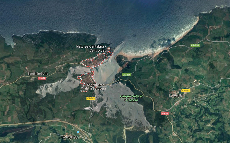
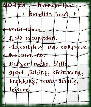
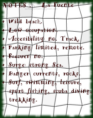
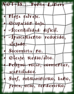
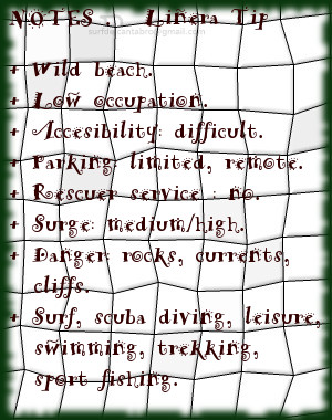
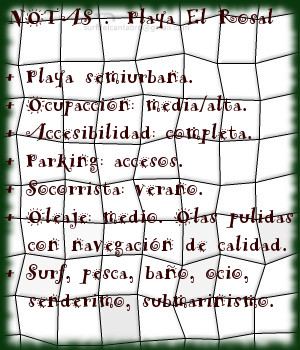
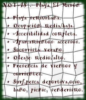
La línea de costa que posee la zona es de gran riqueza y variedad. La parte oeste esta dominada por acantilados, calas y playas: la Ensenada de Fuentes, la Ensenada de Liñera, Punta Cueto María o Punta de la Silla son algunos ejemplos. El Estuario de San Vicente contenido en el Parque Natural de Oyambre, y comunicado con este por el Puente de la Maza, sucede al puerto pesquero. El entorno propicia la riqueza ornitológica existente. Al Este, un extenso arenal recorre la costa. Atravesando la playas de La Maza, Totadero, El Merón y Gerra. Enmacardas entre colinas y rocas el Mar Cantábrico presenta un color azul cristalino de tonalidad onírica que aderezan las olas que bañan la orilla en cada punto.

Icono Inglés. Icon English. San Vicente de la Barquera, villa, village San Vicente de la Barquera is a locality located in the western coast of Cantabria. This seaworthy villa adds the location to its attractives, since its proximity to Asturias turn it into a transient area and vital stop.

The history of the villa sinks its roots in the Age of the Bronze, with remains found in the megalithic deposit of The Barcenal. The Roman epoch designate to the place as Portus Veresasueca, according to recent studies. It is in the Medieval Ages when the development of the population takes place, The Castle of the King of the 8th century marks the point of item. Other examples of its heritage, marked across the centuries, are: The Church of Santa Maria of the Angels representative construction of the Gothic architecture of Cantabria, Puebla vieja and The Tower of the Preboste, …

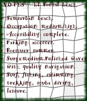
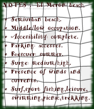
The line of coast that possesses the zone is of great wealth and variety. The West part is dominated by cliffs, coves and beaches: the Inlet of Fuentes, Liñera’s Inlet, Tip Cueto Maria or Tip of the Silla are some examples. The Estuary of San Vicente contained in Oyambre’s Nature reserve, and communicates with this one for the Bridge of the Maza, take place after the fishing port. The environment propitiates the ornithological existing wealth. In the Eastern part, an extensive sandbank crosses the coast. Crossing the beaches of The Maza, Totadero, The Merón and Gerra. Framed between hills and rocks the Cantabrian Sea presents a blue crystalline color of oneiric tonality, that season the waves that bathe the shore in every point.

 San Vicente de la Barquera, villa, village. Icon text divider

San Vicente de la Barquera_, routes

Icono español-inglés. Icon Spanish-English. San Vicente de la Barquera, villa, village. Map San Vicente de la Barquera, village

San Vicente de la Barquera, map

 San Vicente de la Barquera, villa, village. icon close cities

Share

EL Sable, playa

Icono Español. Icon Spanish. El Sable, playa El Sable es una playa situada en la localidad de Prellezo, perteneciente al municipio de Val de San Vicente. Emplazada en el interior de la Ría de Tina Menor, su fisonomía está determinada por el trasiego de las mareas y la configuración del estuario.

El Sable, playa de 350 metros de longitud y apenas 10 metros de anchura media, es un pequeño y particular arenal. Localizada entre la desembocadura del Río Nansa y el cierre de la Ría de Tina Menor, disponen de aguas tranquilas y protegidas de mar abierto. Su entorno natural y salvaje se encuentra poblado de bosque atravesado por senderos. El lado derecho de la ría que ocupa la playa es transitable en marea baja hasta su final y al encuentro con el mar. La tranquilidad natural que reina en la zona convierten la estancia en un reconstituyente descanso.

El otoño trae consigo las grandes mareas, removiendo el fondo de arena y arcilla. Tiñe la zona de color beige y deposita nuevos sedimentos que alimentan la diversidad biológica presente. La primavera hace regresar las aves y completa un sistema que puede ser disfrutado desde la playa de El Sable.

Cabecera Cities Place Beaches . El Sable, playa
El Sable, notas

El Sable, beach

Icono Inglés. Icon English. El Sable, beach El Sable is a beach placed in the locality of Prellezo, belonging to the municipality of Val de San Vicente. Located inside the Estuary of Tina Menor, its physiognomy is determined by the decanting of the tides and the configuration of the tidal river.

El Sable, beach of 350 meters of length and just 10 meters of average width, is an small and particular sandbank. Located between the river mouth of the Nansa River and the closing of Tina Menor, it has calm waters and protected from open sea. Its natural and wild environment is populated of forest crossed by paths. The right side of sea inlet that occupies the beach, it is pasable in low tide until its end and to the meeting with the sea. The natural tranquility that reigns in the zone, turns the stay into a restorative rest.

The autumn brings with it the big tides, removing the bottom of sand and clay. It dyes the zone of beige color and new sediments are despositated that feed the present biological diversity. The spring makes return the birds and completes a system that can be enjoyed from the beach of El Sable.

Cabecera Cities Place Beaches. El Sable, beach
El Sable, notes

Share

Barnejo, playa

Icono Español. Icon Spanish. Barenjo, playa La playa de Barnejo, también llamada playa de Berellín, se encuentra en la localidad de Prellezo, perteneciente al municipio de Val de San Vicente. Emplazada en la costa occidental de Cantabria, de reducidas dimensiones, descubre un área singular de especial belleza.

La Punta del Morro de Berellín y la Punta de África, dos pequeños cabos que se ubican en la zona, delimitan la Ensenada de Berellín. La playa está contenida en la ensenada que compuesta por formaciones kársticas y un dibujo libre e irregular de la costa va abriendo la entrada al mar a través de sus acantilados. Apenas 100 metros en la parte más ancha, crean un canal que serpentea a lo largo de casi 800 metros de longitud.

El diferente y potente paisaje que rodea a la playa, estimula los sentidos que por los senderos van descubriendo la zona. Las aguas tranquilas y de color verdoso traslucen el fondo arenoso que invita a disfrutar de un relajado baño. El amanecer, su atardecer, el mediodía se convierten en diferentes y buenos perfiles de una misma postal.

Cabecera Cities Place Beaches . Barnejo, playa
Barnejo, notas

Barnejo, beach

Icono Inglés. Icon English. Barnejo, beach Barnejo beach, also called the beach of Berellín, is in the locality of Prellezo, belonging to the municipality of Val de San Vicente. Located on the western coast of Cantabria, with limited dimensions, it discovers a singular area of special beauty.

The Tip of El Morro de Berellín and the Tip of Africa, two small capes that are located in the zone, delimit Berellín’s Inlet. The beach is contained in the inlet that composed by karst formations and with a free and irregular drawing of the coast, opens the entry to the sea across its cliffs. Hardly with 100 meters in the broadest part, believe a channel that winds along almost 800 meters of length.

The different and powerful landscape that is around the beach, stimulates the senses that through the paths are discovering the zone. The calm waters and of greenish color reveal the sandy bottom that invites to enjoy a relaxed bathe. The dawn,the sunset afternoon, the midday turn into different and good profiles of the same postcard.

Cabecera Cities Place Beaches. Barnejo, beach
Barnejo, notes

Share

La Fuente, playa

Icono Español. Icon Spanish. La Fuente, playa La playa La Fuente, ubicada en San Vicente de las Barquera; en la costa occidental de Cantabria, es una pequeña cala de 150 metros de longitud y 20 metros de anchura media. Conservada prácticamente en estado natural, presenta baja ocupación y no dispone de ningún servicio.

La Punta de África, a la izquierda, y la Punta del Fraile, a la derecha, contienen la ensenada y delimitan el arenal. Sus reducidas dimensiones y orografia descubren un entorno singular. Abierta al mar, recibe la fuerza del Cantánbrico que baña la costa y es modulado por los acantilados de la zona. El fuerte oleaje que llega a La Fuente abre a ambos lados. El corto recorrido que alcanzan las ondas favorece las maniobras. La profundidad de la Ensenada de Fuentes proporciona varios picos de olas, a diferentes distancias de la orilla. A medida que avanzamos hacia mar abierto las corrientes, ya presentes, aumentan su fuerza. Por este motivo, adentrarse a los picos alejados es sólo recomendable para surfers experimentados y conscientes de los riesgos.

La apartada localización, las dimensiones, rocas y corrientes son características que definen a esta cala y proyectan virtudes que ayudan a desconectar mientras se surfea y disfruta de su diferente navegación.

Cabecera Cities Place Beaches . La Fuente, playa
La Fuente, notas

La Fuente, beach

Icono Inglés. Icon English. La Fuente, beach The beach of La Fuente, located in San Vicente de la Barquera; on the western coast of Cantabria, it is a small cove with 150 meters of length and 20 meters of average width. Preserved practically in natural condition, it presents low occupation and has not any service.

The Tip of Africa, to the left side, and the Tip of El Fraile, to the right, contain the inlet and delimit the sandbank. Its limited dimensions and orography discover a singular environment. Opened the sea, it receives the force of the Cantánbrico that washes the coast and is modulated by the cliffs of the zone. The strong surge that comes to La Fuente opens to both sides. The short tour that the waves reach favors the maneuvers. The depth of the Inlet of Fuentes provides several beaks of waves, to different distances of the shore. As we advance towards open sea the currents, already present, increases its force. Due to this motive, to enter to the remote beaks, is only advisable for experienced surfers and conscious of the risks.

The isolated location, the dimensions, rocks and currents are features that define to this cove and project virtues that help to disconnect while you are surfing and enjoying its different navigation.

Cabecera Cities Place Beaches. La Fuente, beach
La Fuente, notes

Share

Punta Liñera, playa

Icono Español. Icon Spanish. Punta Liñera, playa Punta Liñera es un pequeña cala emplazada en San Vicente de la Barquera, en la costa oriental de Cantabria. Sus reducidas dimensiones, apenas 150 metros en un parte más ancha; con la arena sólo visible en marea baja, sirven de acceso a un entorno que ofrece múltiples posibilidades.

Punta Liñera, nombre que recibe el cabo que protege y bautiza la cala, forma una ensenada que es acotada en su extremo derecho por la Punta del Castillo. La rasa mareal que cimenta sus fondos contribuye a crear un rico ecosistema y contribuye a la biodiversidad de sus aguas. Fondos de roca pulida y erosionada por efecto del Mar Cantábrico a lo largo del tiempo habitan cerca de la costa. Más allá, el Mar arriba libre recorriendo la costa y formando una ola característica de izquierdas, rápida y tubera.

EL paseo por los acantilados descubre la amplitud del entorno y su riqueza paisajística. Hacia el Oeste la costa de Pechón, al Este la costa de San Vicente de la Barquera. Refulgente visión que fusionará el espacio con la imaginación

Cabecera Cities Place Beaches . Punta Liñera, playa
Punta Liñera, notas

Liñera Tip, beach

Icono Inglés. Icon English. Liñera Tip, beach Liñera Tip is an small cove located in San Vicente de la Barquera, on the oriental coast of Cantabria. Its limited dimensions, no more than 150 meters in its width; with the sand only visible in low tide, is used as access to an environment that offers multiple possibilities.

Liñera Tip, name that receives the end that protects and baptizes the cove, forms an inlet that is annotated in its right wing by El Castillo Tip. The tidal plain that establishes its funds helps to create a rich ecosystem and the biodiversity of its waters. Funds of polished and eroded rock by effect of the Cantabrian Sea throughout the time are near the coast. Beyond, the Sea arrives freely crossing the coastline and forming a characteristic wave that open to left sides, with speed and pipes.

The promenade along the cliffs discovers the extent of the environment and its landscape wealth. Towards the West Pechón’s coast, in the eastern part San Vicente de la Barquera coast. Refulgent vision that would fuse the space with the imagination

Cabecera Cities Place Beaches. Liñera Tip, beach
PuntaLiñera, notes

Share

El Rosal, playa

Icono Español. Icon Spanish. El Rosal, playa La playa El Rosal, también conocida como Tostadero, está situada en el municipio de San Vicente de la Barquera, en la costa occidental de Cantabria. Delimitada en su lado izquierdo por un espigón que separa el arenal de la Ría de San Vicente de la Barquera. Su longitud de 360 metros y anchura media de 60 metros disponen una pequeña área parcialmente protegida del oleaje.

Cuenta, su espigón, con un pequeño faro en el extremo final. Este punto, situado a 150 metros de la orilla, es conocido como el Farolillo. La zona dispone de otro malecón natural, el Islote de Peña Menor, que cubre totalmente al primero. Estas barreras naturales que preservan a la zona del Mar Cantábrico y filtran el oleaje que hasta allí llega, junto con las características del entorno ayudan a producir unas ondas especiales que abren sus alas a lo ancho para llegar posteriormente hasta el arenal.

Cuando las series de olas salvan los espigones, nace una ola que abre a ambos lados. De pendiente suave y prolongada, aparecen recorridos medios a derechas. Sí las condiciones son favorables la apertura izquierda de la onda puede alcanzar un trayecto mayor. La superficie pulida del agua, el rizamiento de la ola y el desplazamiento prolongado de las elevaciones que transportan las ondas consiguen crear olas cuyos parámetros son sólo valores que, en conjunto y después de surfear, hablan de la naturaleza del Cantábrico en esta parte de Cantabria.

Cabecera Cities Place Beaches. El Rosal, playa
El Rosal, notas

El Rosal, playa

Icono Inglés. Icon English. El Rosal, beach The beach El Rosal, also known as Tostadero, is placed in the municipality of San Vicente de la Barquera, in the western coast of Cantabria. Delimited in its left side for a breakwater that separates the sandbank of the Stuary of San Vicente de la Barquera. Its length of 360 meters and average width of 60 meters arrange an small area partially protected from the surge.

It counts,its dyke,with an small beacon in the final end. This point placed to 150 meters of the shore, is known as el farolillo. The zone has another natural levee, Peña Menor Islet, which covers totally to the first one. These natural barriers that preserve to the zone of the Cantabrian Sea and leak the surge that comes up to there, together with the characteristics of the environment help to produce a few special waves that open its wings widthways; and will arrive later up to the sandbank.

When the series of waves overcomes the levees, there is born a wave that opens to both sides. Of soft and long slope, a medium distance tours that open to the right appear. If the conditions are favorable the left opening of the wave can reach a major distance. The polished surface of the water, the curling of the wave and the long displacement of the elevations that transport the waves manage to create waves which parameters are only values that as a whole and after surfing speak about the nature of the Cantabrian Sea in this part of Cantabria.

Cabecera Cities Place Beaches. El Rosal, beach
El Rosal, notes

Share

El Merón, playa

Icono Español. Icon Spanish. El Meron playa La playa El Merón está situada en San Vicente de la Barquera, municipio emplazado en la costa occidental de Cantabria. Su longitud de 2,5 kilómetros y anchura media aproximada de 60 metros, la convierten en una de las playas más extensas de Cantabria. La marea baja descubre una llanura de arena fina y compacta, sobre la que se forman y desarrollan distintos tipos de olas que el Mar Cantábrico transporta y entrega.

Delimitada en su extremo izquierdo por el espigón que separa la Ría de San Vicente de la Barquera del arenal, aparece un extenso área acotada y protegida parcialmente de la fuerza del Mar. Dibuja la costa en este punto una ligera curva que propicia variedad de olas, en cuanto a forma y extensión. Abriendo las ondas a ambos lados, destacan sus izquierdas. Alargadas y con su pared de agua sostenida, van trasladando la parte navegable de la ola hasta el final del trayecto curvado.

Continua la playa en línea recta hasta su otro extremo, al encuentro con la playa de Gerra. Es esta una zona de gran amplitud, con abundantes picos de olas que abren a ambos lados. Disponen sus ondas de varios niveles de profundidad, a diferentes distancias de la orilla. No siendo esta regla regular, cuando se cumple ofrece un variado repertorio de opciones para todos los niveles e intensidades. Destaca la naturaleza del Mar en esta parte de la costa Cántabra. La llegada de las series de olas sobre volúmenes de agua que proporcionan una suave pendiente libre y limpia para la navegación. Acuden ellas al encuentro con la fina arena sin demora, ni prisa, trasluciendo a través de su velocidad óptima una parte de su alma.

La potencia progresiva y rítmica de las aguas del Merón, produce un discurso familiar por conocido, que el recuerdo; una vez de vuelta, distinguirá como singular y único.

Cabecera Cities Place Beaches. El Meron playa
El Meron playa. Notas

The Merón, beach

Icono Inglés. Icon English. El Merón, beach The beach The Merón is placed in San Vicente de la Barquera, municipality located in the western coast of Cantabria. Its length of 2,5 kilometres and average approximate width of 60 meters, turn it into one of the most extensive beaches of Cantabria. The low tide discovers a plain of thin and compact sand, over it are formed and develop different types of waves, that are transported and delivered by the Cantabrian Sea.

Delimited in its left wing by the breakwater that separates the Stuary of San Vicente de la Barquera of the sandbank, appears an extensively and protected area which is partially shield against the force of the Sea. The coast draws, in this point, a light curve that propitiates variety of waves, in its form and extension. The waves open for both sides, stand out its left sides. Lengthened and with its supported wall of water, them move its navigable part to the end of the curved route.

It continues the beach on straight line up to its other end, to the meeting with Gerra’s beach. It is this zone of great extent, with abundant beaks of waves that open to both sides. It arrange its waves in several levels of depth, to different distances of the shore. Not being this regular rule, when it is fulfilled; it offers a varied digest of options for all the levels and intensities. The nature of the Sea stands out in this part of the Cantabrian coast. The arrival of the series of waves in water volumes which provide a soft, free and clean slope for the navigation. Them come to the encounter with the thin sand, without delay, or hurry, revealing across its ideal speed; a part of its soul.

The progressive and rhythmic power of the Merón’s waters, produces a familiar speech as known before, that the recollection; once of return, will distinguish like singular and unique.

Cabecera Cities Place Beaches. El Merón beach
El Merón beach . Notes

Share

Gerra, playa

Icono Español. Icon Spanish. Gerra, playa La playa Gerra, también llamada El Cabo, se encuentra en el municipio de San Vicente de la Barquera; en la costa occidental de Cantabria. Situada en la cara oeste del cabo que une la costa de San Vicente de la Barquera con la costa de Oyambre, es una playa de 900 metros de longitud y una anchura media aproximada de 30 metros.

Su escarpado acceso esconde parcialmente a Gerra y da entrada a un emplazamiento idílico con vistas panorámicas, que en los días de buena visibilidad muestran parte de la costa asturiana y Los Picos de Europa. A los pies de los acantilados y protegida por El Cabo de Oyambre, recoge los vientos de la ensenada y las corrientes de la zona. Destaca la calidad de sus aguas, limpias y trasparentes, que dejan traslucir sus fondos cerca de la orilla; sólo enturbiada por las fuertes corrientes que hay en el área y el viento, presente de manera habitual.

El emplazamiento de Gerra, entre acantilados y formaciones rocosas, hacen que su fondo arenoso se mezcle con rocas sueltas y diseminadas por todo el área. Las zonas cercanas a la orilla y próximas al pico PeñaEntera son evitables en la práctica del surf, pues además las corrientes son fuertes cerca de la pico montañoso que delimita a Gerra. Nacen las olas a 100 metros de la arena, siendo su recorrido de pequeña e «intensa» extensión. Abren sus olas a izquierdas y derechas, combandose por el trazado curvo de la playa, favoreciendo las maniobras y el viaje activo para su navegación.

Corre el aire, vuela sobre las aguas de Gerra, proporcionando energía a sus olas, moldeando sus formas. Prologando en el tiempo y en el espacio las paredes de agua que allí se forman. Si está ausente, es que ya pasó, y sobre las ondas reflejado queda su filtrado, su pulido acabado, sello característico de esta singular zona de la costa cántabra.

comic, mountain
Gerra, notas

Gerra, beach

Icono Inglés. Icon English. Gerra, beach The beach of Gerra, also called El Cabo, is in the municipality of San Vicente de la Barquera; on the western coast of Cantabria. Placed in the west side that joins the coast of San Vicente de la Barquera with Oyambre’s coast, is a beach of 900 meters of length and an average approximate width of 30 meters.

Its steep access hides partially Gerra and gives entry to an idyllic emplacement with panoramic view, that in the days of good visibility show part of the Asturian coast and the massif Picos de Europa. To the feet of the cliffs and protected by Oyambre’s Cape, which gathers the winds of the inlet and the currents of the zone. Stands out the quality of its waters, clean and clear, that show its funds near the shore; only muddied by the strong currents that exist in the area and the wind, present in an habitual way.

The emplacement of Gerra, between cliffs and rocky formations, which do that its sandy bottom mixes with free and scattered rocks in all the area. The zones near to the shore and next the beak PeñaEntera are avoidable in the practice of the surf, since in addition the currents are strong near its mountainous peak that delimits Gerra. The waves are born to 100 meters of the sand, being its tour with small and intense extension. It open its waves for left and rights sides, curving because of the curved tracing of the beach, favoring the maneuvers and the active trip for its navigation.

It traverses; the air, flies on Gerra’s waters, providing energy to its waves, molding its forms. It extend, in the time and in the space, the water walls that there are formed. If it is not in, it is that already it happened, and on the waves is reflected its filtered, its polished ended, typical stamp of this singular zone of the Cantabrian coast.

comic, mountain
Gerra, notes

Share

Oyambre, playa

Icono Español. Icon Spanish. Oyambre, playa La playa de Oyambre está situada en el municipio de Valdáliga, emplazado en la costa occidental de Cantabria. Situada dentro del Parque Natural de Oyambre, es un extenso arenal de 1800 metros de longitud dispuestos en linea recta y curvando su ala izquierda por la morfología de su entorno dominado por acantilados. El extremo derecho continúa a través de la costa cántabra hasta perderse en el horizonte.

La entrada a la playa se realiza a través de un pequeño aparcamiento habilitado para 50 vehículos, aproximadamente. La contemplación de Oyambre produce en el caminante una sensación acogedora e intima, que contrasta con la amplitud y enormidad del entorno. Salvaje y naturalmente dibujada, es recorrida por el viento en toda su plenitud que la visita de forma casi regular. Su extensión se plasma por medio de una llanura de arena endurecida, con una leve pendiente hasta la orilla, a modo de invitación para conocer sus aguas. La playa de oyambre, por sus características, sirvió en el siglo pasado de pista de aterrizaje del llamado «Pájaro amarillo»; primer avión que cruzó el Océano Atlántico en una travesía de 29 horas. Esto da una idea de la singularidad del lugar.

Baña el Mar la costa y la playa, ondula suavemente el fondo arenoso por los efectos de las mareas y el oleaje. Aparecen las ondas en diversos picos de olas que existen en la playa. Su forma pulida y recorrido alargado,en la zona central, se combina con áreas donde estas recorren menor extensión y favorecen las maniobras. Golpea el Mar Cantábrico al surfista, iniciando así la navegación, naciendo su viaje sobre las olas. Travesía prolongada y colmada, pues a la energía que inyecta la velocidad se suma la pureza del agua, del aire, la belleza de la costa al fondo, que por sensaciones llegan a uno mismo y terminan por prender el fuego en el interior.

comic, mountain
Playa de Oyambre, notas

Oyambre, beach

Icono Inglés. Icon English. Oyambre, beach The beach of Oyambre is placed in the municipality of Valdáliga, located in the western coast of Cantabria. Housed inside the Nature Reserve of Oyambre, it is an extensive sandbank of 1800 meters of length arranged on straight line; with a left wing curved because of the morphology of its environment dominated by cliffs. The right wing continues across the Cantabrian coast up to getting lost in the horizon.

The entry to the beach is realized across an small parking enabled for 50 vehicles, approximately. Oyambre’s contemplation produces in the wayfarer a cozy and intimate sensation, that contrasts with its length and enormity of its environment. Wild and naturally drawn, is crossed by the wind in all its fullness that visits it almost regularly. Its extension takes form by means of a plain of hard sand, with a slight earring up to the shore, as an invitation to know his waters. The beach of Oyambre, for its characteristics, was used int the last century as a runway of the so called yellow Bird; the first plane that crossed the Atlantic Ocean in a voyage of 29 hours. This gives an idea about the singularity of the zone.

The Sea bathes the coast and the beach, it waving softly the sandy bottom due to the effects of the tides and the surge. The waves appear in diverse beaks that exist in the beach. Its polished form and elongated tour, in the central zone, combines with areas where them are in less extension and allow the maneuvers. It strikes the Cantabrian Sea to the surfer, initiating in this way the navigation, borning his trip on the waves. Long and fulfilled voyage, because at the energy that injects the speed is added the purity of the water, of the air, the beauty of the coast in the background, which through its sensations come to oneself and them end for lighting the fire inside.

comic, mountain
Oyambre beach, notes

Share

Playa El Pedrero, acceso

Icono Español. Icon Sapnish. La Playa del Pedrero está situada en la localidad de Pechón, perteneciente al municipio de Val de san Vicente. Es la playa más occidental de Cantabria. Ubicada en la desembocadura de la Ría de Tina Mayor, es apta para el baño y el ocio. Es una zona con presencia de corrientes. Existe un pequeño aparcamiento desde el cual se llega a una pequeña senda, con escaleras, que conducen directamente a la playa.

El Pedrero Beach, access

Icono Inglés. Icon English. The Beach of El Pedrero is placed in the locality of Pechón, belonging to the municipality of Val de san Vicente . It is the most western beach of Cantabria. Located in the river mouth of the Estuary of Tina Mayor , it is suitable for the swiming and the leisure. It is a zone with currents . There exists an small parking from which you will arrive to one way, with stairs, which lead directly to the beach.

Icono español-inglés. Icon Spanish-English. Acceso/Access

El Pedrero: access

Share