Comillas, villa
![]() Comillas, villa y municipio situado en la costa occidental de Cantabria, dispone de un variado litoral con irregular forma. Los cabos Punta de la Guerra y Punta del Miradoiro contiene la Ensenada de Fonfría. EL puerto pesquero, la playa de Comillas y los acantilados son algunos de los atractivos de su costa que junto con el Paseo Marítimo, redondean una bella imagen de gratificante contemplación en cualquiera de los puntos de su recorrido. Las localidades que componen el municipio son: La Rabia, Rioturbio, Rubárcena, Ruiseñada, Trasvía y Comillas; capital de la circunscripción.
Comillas, villa y municipio situado en la costa occidental de Cantabria, dispone de un variado litoral con irregular forma. Los cabos Punta de la Guerra y Punta del Miradoiro contiene la Ensenada de Fonfría. EL puerto pesquero, la playa de Comillas y los acantilados son algunos de los atractivos de su costa que junto con el Paseo Marítimo, redondean una bella imagen de gratificante contemplación en cualquiera de los puntos de su recorrido. Las localidades que componen el municipio son: La Rabia, Rioturbio, Rubárcena, Ruiseñada, Trasvía y Comillas; capital de la circunscripción.
La abundancia de cuevas, debido a su orografía, que cuentan con pinturas y útiles dan testimonio de la presencia de pobladores desde la prehistoria. Destacan la Cueva de la Meaza, la Cueva de Portillo y el castro de la Peña del Castillo. La Mina Numa situdada en la localidad de Ruiseñada, explotada desde la antiguedad conserva restos de la época romana. Los documentos más antiguos que asientan la historia de Comillas datan del siglo XI, a partir de aquí se entremezcla el desarrollo de la villa, las artes, oficios y su desarrollo arquitectónico jalonando siglo a siglo. La industria ballenera, la torre de Garcilaso I de la Vega (conocida como el Torreón), el desarrollo del puerto, la Iglesia parroquial que cuenta con reconstrucciones en diferentes épocas, son algunos de los episodios históricos que se han escrito en la villa de Comillas.
En la actualidad la arquitectura modernista realizada en el siglo XIX constituye la muestra más visible de su patrimonio. El Palacio de Sobrellano, El Capricho de Gaudí y La Universidad Pontificia de Comillas son las singularidades que coronan la belleza asentada desde el pavimento de sus calles, colinas y prados, la particular configuración de su territorio que dio origen a su nombre.
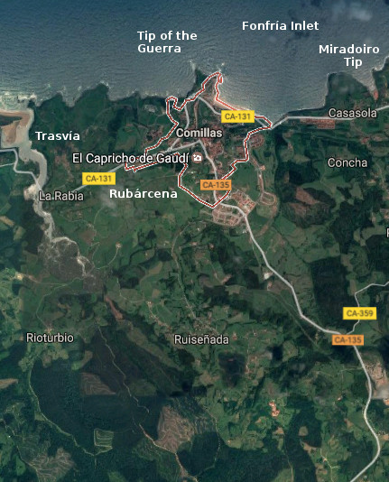
![]() Comillas, village and municipality placed in the western coast of Cantabria, has a varied littoral with irregular form. The capes: Tip of the Guerra and Tip of the Miradoiro contains the Inlet of Fonfría. The fishing port, the beach of Comillas and the cliffs are some of the attractives of its coast, that combined with the Maritime Promenade, round up a beautiful image of gratifying contemplation in any of the points of its tour. The localities that compose the municipality are: La Rabia, Rioturbio, Rubárcena, Ruiseñada, Trasvía and Comillas; capital of the circumscription.
Comillas, village and municipality placed in the western coast of Cantabria, has a varied littoral with irregular form. The capes: Tip of the Guerra and Tip of the Miradoiro contains the Inlet of Fonfría. The fishing port, the beach of Comillas and the cliffs are some of the attractives of its coast, that combined with the Maritime Promenade, round up a beautiful image of gratifying contemplation in any of the points of its tour. The localities that compose the municipality are: La Rabia, Rioturbio, Rubárcena, Ruiseñada, Trasvía and Comillas; capital of the circumscription.
The abundance of caves, due to its orography, which possess paintings and useful that give testimony of the settlers’ presence from the prehistory. Stand out the Cave of the Meaza, the Cave of Portillo and the Celtic fortification of the Peña del Castillo. The Mine Numa placed in Ruiseñada’s locality, exploited since anciente times preserv rests of the Roman epoch. The most former documents that agree the history of Comillas date back to the 11th century, from here there intermingles the development of the villa, the arts, trades and its architectural development marking century a century. The whaler industry, the tower of Garcilaso I de la Vega (known as the Torreón), the development of the port, the parochial Church that possesses reconstructions in different epochs, are some of the historical episodes that have been written in the village of Comillas.
At present, the modernist architecture realized in the 19th century constitutes the most visible sample of its heritage. The Palace of Sobrellano, The Caprice of Gaudí and The University Pontificia of Comillas are the singularities that crown the beauty seated from the pavement of its streets, hills and meadows, the particular configuration of the territory that gave origin to its name.
![]()

 Comillas, village