Category Archives: Cities

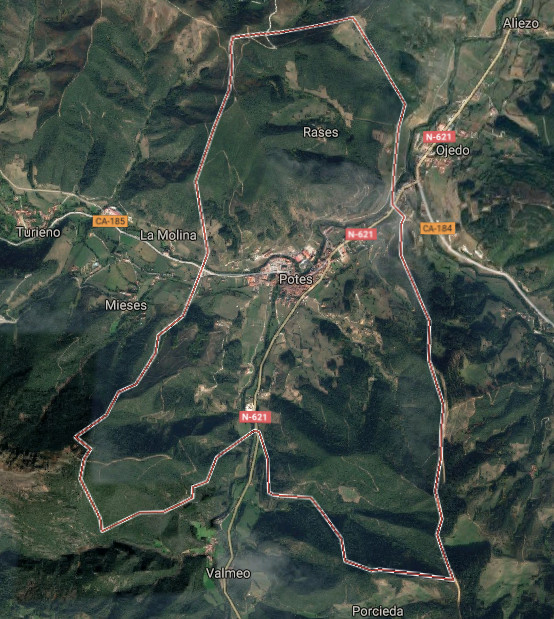
Potes, villa y capital de Liébana
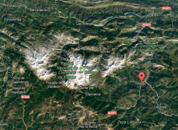
![]() Potes es una localidad situada en la región occidental de Cantabria. Emplazada en la comarca de Liébana y siendo su capital, se encuentra a 291 metros de altitud, en el corazón del Parque Nacional de Picos de Europa.
Potes es una localidad situada en la región occidental de Cantabria. Emplazada en la comarca de Liébana y siendo su capital, se encuentra a 291 metros de altitud, en el corazón del Parque Nacional de Picos de Europa.
La localización única de la villa la convierte en un punto de encuentro de cuatro valles. Recibe la desembocadura del Río Quiviesa, que sirve de afluente al Río Deva el cual nace en el Macizo Cántabrico. La orografía montañosa que perfila su contorno delimita la comarca y configura un entorno natural excepcional. La existencia de valles en su interior representa diferencias de altitud y crea un microclima mediterráneo en el fondo de este gran valle que se torna atlántico a medida que ascendemos hasta los picos que alcanzan los 2000 metros.
Habitada desde tiempos prehistóricos, fue repoblada en el siglo VIII y IX durante La Reconquista. En aquella época recibió numerosa población que contribuyó a enriquecer la vida y cultura de Liébana a lo largo de la Edad Media. Destacan la Torre del Infantado, Torre del Orejón de la Lama, la Iglesia de San Vicente y el Puente de San Cayetano cómo muestras arquitectónicas de una época. La configuración de Potes, sus barrios, calles y plazas trasmiten el paso del tiempo y la historia vivida. Los barrios de la Solana y el Sol concentran numerosas edificaciones que hacen del casco histórico Bien de Interés Cultural.
Es su clima característico el que posibilita la existencia del cultivo de la vid que sirve para elaborar el orujo de Potes. Abundan las encinas y alcornoques, característicos del bosque mediterráneo, entremezclados con especies propias del bosque atlántico como el hayedo y el roble. Otras especies como tejos, alisos, acebos, avellanos, chopos … amplían la diversidad y embellecen su naturaleza.
Potes, village and capital of Liébana
![]() Potes it is a locality placed in the western region of Cantabria. Located in the region of Liébana and being its capital, it is to 291 meters of altitude, in the heart of the National Park of Picos de Europa.
Potes it is a locality placed in the western region of Cantabria. Located in the region of Liébana and being its capital, it is to 291 meters of altitude, in the heart of the National Park of Picos de Europa.
The unique location of the villa turns it into a point of meeting of four valleys. It receives the river mouth of the river Quiviesa, tributary to the Rio Deva which is born in the Cantabrian Range. The mountainous orography that outlines his contour delimits the region and forms an excepcional natural environment. The existence of valleys inside it represents differences of altitude and creates a Mediterranean microclimate at the back of this great valley that becomes Atlantic as we ascend up to the beaks that reach 2000 meters.
Populated from prehistoric times, it was repopulated in the 8th century and the IXth during The Reconquest. In that epoch Potes received numerous population who helped to enrich the life and culture of Liébana along the Middle Ages. Emphasize the Tower of the Infantado, Tower of Orejón de la Lama, San Vicente’s Church and San Cayetano’s Bridge as architectural examples of an epoch. The configuration of Potes, its neighborhoods, streets and squares transfer the passage of time and the lived history. The neighborhoods of the Solana and the Sol concentrate numerous buildings that do of the historical center an Heritage of Cultural Interest.
It is its typical climate the one that makes possible the existence of the culture of the grapevine that serves to elaborate the grape marc of Potes. The holm oaks and cork oaks abound, typical of the Mediterranean forest, intermingled with own species of the Atlantic forest as the hayedo and the oak. Other species like yews, alder-trees, hollies, hazels, black poplars … extend the diversity and embellish its nature.
![]()

 Potes, village
Liébana, natural area

Pechón, villa
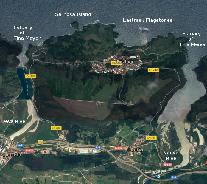
![]() Pechón es una localidad situada en el extremo occidental de Cantabria, perteneciente al municipio de Val de San Vicente. El característico emplazamiento y singular entorno que dispone la villa lo convierten en un destino único, cuya oferta de ocio cuenta con una variada gama de opciones.
Pechón es una localidad situada en el extremo occidental de Cantabria, perteneciente al municipio de Val de San Vicente. El característico emplazamiento y singular entorno que dispone la villa lo convierten en un destino único, cuya oferta de ocio cuenta con una variada gama de opciones.
Dos estuarios delimitan y configuran la península sobre la que se establece Pechón. La Ría de Tina Mayor, en el extremo Oeste, compartida con Asturias y establecida sobre una plataforma de erosión que recibe la desembocadura del Río Deva. La Ría de Tina Menor se encuentra en la desembocadura del Río Nansa y se asienta sobre otra plataforma de abrasión que se escalona con la anterior y acota el extremo Este. Al frente, el Mar Cantábrico baña el litoral, recorriendo lastras, islas y acantilados. La línea de costa, de forma irregular, recibe el oleaje desde tiempos remotos reflejando en su trazado el arte que el Mar y el Tiempo proponen.
El destino allí comenzará con una ascensión hasta el núcleo de población. Flanqueada la travesía con sendos ríos, es acompañado con rocas y praderas más adelante. Rincones bonitos, prados de verde intenso, la abundancia de rocas que conforman sus paisajes y varios miradores potenciarán las sensaciones que registrarán un dulce recuerdo a la partida.
![]() Pechón is a locality placed in the Western end of Cantabria, belonging to the municipality of Val de San Vicente. The characteristic emplacement and singular environment that provides the village, turn it into the unique destination which leisure possesses a varied range of options.
Pechón is a locality placed in the Western end of Cantabria, belonging to the municipality of Val de San Vicente. The characteristic emplacement and singular environment that provides the village, turn it into the unique destination which leisure possesses a varied range of options.
Two estuaries delimit and form the peninsula on which Pechón is established. The Estuary of Tina Mayor, in the West extreme, shared with Asturias and established on a platform of erosion that receives the river mouth of the River Deva. The Estuary of Tina Menor finds in the river mouth of the River Nansa and lives on another platform of erosion that is staggered from the previous one and encloses the East extreme. To the front, the Cantabrian Sea laps the littoral, crossing flagstones, islands and cliffs. The line of coast, with irregular form, receives the surge from remote times reflecting in its tracing the art that the Sea and the Time propose.
The destination there will begin with an ascension up to the center of population. Flanked the voyage with each river mouth, it is accompanied with rocks and fields, hereinafter. Nice corners, meadows of intense green, the abundance of rocks that its landscapes shape and several viewing-points will promote the sensations that will register a sweet recollection to the leaving.
![]()

Pechón, village
Prellezo, villa
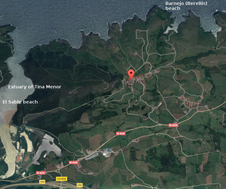
![]() Prellezo es una pequeña y hermosa localidad situada en la costa occidental de Cantabria y perteneciente al municipio de Val de San Vicente. Su baja densidad de población contrasta con su extensión, lo que la convierte en un destino ideal para disfrutar de la naturaleza salvaje y alejada del ruido mundano.
Prellezo es una pequeña y hermosa localidad situada en la costa occidental de Cantabria y perteneciente al municipio de Val de San Vicente. Su baja densidad de población contrasta con su extensión, lo que la convierte en un destino ideal para disfrutar de la naturaleza salvaje y alejada del ruido mundano.
Prellezo presenta su patrimonio al caminante, destacando un yacimiento arqueológico descubierto recientemente y cuya antiguedad se data entre el paleolítico inferior y el mesolítico. Conocido como El Castro del Castillo, cuenta con una localización costera y comunicada con tierra firme por un istmo. Las dos hectáreas del promontorio descansan sobre rasa mareal y esta protegido por el mar y construcciones defensivas.
La riqueza natural y paisajística de Prellezo, compuesta por praderas y montes, es potenciada por el marco litoral que la delimita. La combinación que crea la costa con los prados amalgama la esencia de la zona que adquiere mayor expresión sensorial a través de las ensenadas, acantilados, calas y rocas. La Ría de Tina Menor proporciona un espacio de gran riqueza biológica, perceptible en varios aspectos desde cualquier punto, pues el trasiego de las mareas permite la diversidad y emociona a la tierra.
![]() Prellezo is an small and beautiful locality placed in the western coast of Cantabria and belonging to the municipality of Val de San Vicente. Its low density of population contrast with its extension, which turns it into an ideal destination to enjoy the nature wild and far from the worldly noise.
Prellezo is an small and beautiful locality placed in the western coast of Cantabria and belonging to the municipality of Val de San Vicente. Its low density of population contrast with its extension, which turns it into an ideal destination to enjoy the nature wild and far from the worldly noise.
Prellezo presents its heritage to the wayfarer, emphasizing an archaeological deposit discovered recently and whose exage is dated between the low Paleolithic and the Mesolithic. Acquaintance as The Castro of Castillo, possesses a coastal location and communicated with mainland through an isthmus. The two hectares of the promontory rest on tidal plain, protected by the sea and defensive constructions.
Prellezo’s natural and landscape wealth, composed for meadow and mounts, is strengthened by the coastal frame that delimits it. The combination that creates the coast with the meadows amalgamates the essence of the zone that acquires major sensory expression across the inlets, cliffs, coves and rocks. The Estuary of Tina Menor provides a space with great biological wealth, perceptible in several aspects from any point, due to the decanting of the tides that allows the diversity and thrills the land.
![]()

Prellezo, village
San Vicente de la Barquera, villa
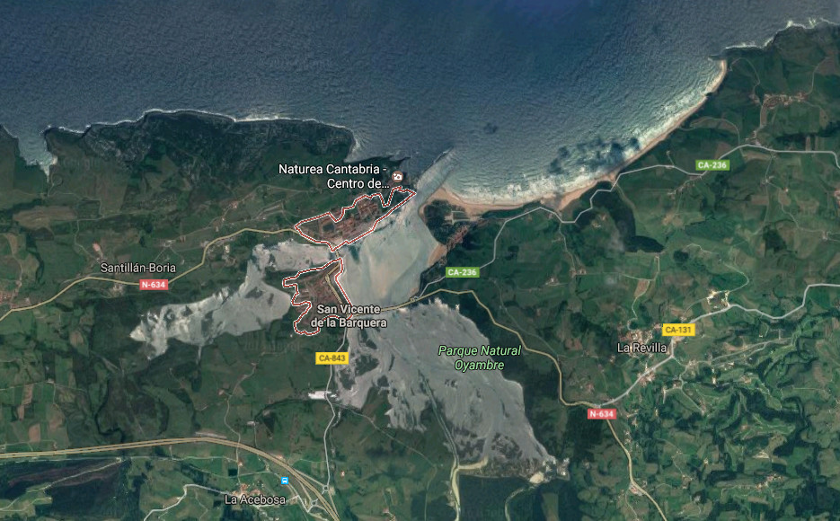
![]() San Vicente de la Barquera es una localidad emplazada en la costa occidental de Cantabria. Esta villa marinera añade la localización a sus atractivos, pues su proximidad a Asturias la convierten en un lugar de paso y parada obligada.
San Vicente de la Barquera es una localidad emplazada en la costa occidental de Cantabria. Esta villa marinera añade la localización a sus atractivos, pues su proximidad a Asturias la convierten en un lugar de paso y parada obligada.
La historia de la villa hunde sus raíces en la Edad del Bronce, con restos encontrados en el yacimiento megalítico de El Barcenal. La época romana designo al lugar como Portus Veresasueca, según estudios recientes. Es en la Edad Media cuando se produce el desarrollo de la población, EL Castillo del Rey del siglo VIII marca el punto de partida. Otros ejemplos de su patrimonio, jalonado a través de los siglos, son: La Iglesia de Santa María de los Ángeles construcción representativa de la arquitectura gótica de Cantabria, La Puebla vieja y La Torre del Preboste, …
La línea de costa que posee la zona es de gran riqueza y variedad. La parte oeste esta dominada por acantilados, calas y playas: la Ensenada de Fuentes, la Ensenada de Liñera, Punta Cueto María o Punta de la Silla son algunos ejemplos. El Estuario de San Vicente contenido en el Parque Natural de Oyambre, y comunicado con este por el Puente de la Maza, sucede al puerto pesquero. El entorno propicia la riqueza ornitológica existente. Al Este, un extenso arenal recorre la costa. Atravesando la playas de La Maza, Totadero, El Merón y Gerra. Enmacardas entre colinas y rocas el Mar Cantábrico presenta un color azul cristalino de tonalidad onírica que aderezan las olas que bañan la orilla en cada punto.
![]() San Vicente de la Barquera is a locality located in the western coast of Cantabria. This seaworthy villa adds the location to its attractives, since its proximity to Asturias turn it into a transient area and vital stop.
San Vicente de la Barquera is a locality located in the western coast of Cantabria. This seaworthy villa adds the location to its attractives, since its proximity to Asturias turn it into a transient area and vital stop.
The history of the villa sinks its roots in the Age of the Bronze, with remains found in the megalithic deposit of The Barcenal. The Roman epoch designate to the place as Portus Veresasueca, according to recent studies. It is in the Medieval Ages when the development of the population takes place, The Castle of the King of the 8th century marks the point of item. Other examples of its heritage, marked across the centuries, are: The Church of Santa Maria of the Angels representative construction of the Gothic architecture of Cantabria, Puebla vieja and The Tower of the Preboste, …
The line of coast that possesses the zone is of great wealth and variety. The West part is dominated by cliffs, coves and beaches: the Inlet of Fuentes, Liñera’s Inlet, Tip Cueto Maria or Tip of the Silla are some examples. The Estuary of San Vicente contained in Oyambre’s Nature reserve, and communicates with this one for the Bridge of the Maza, take place after the fishing port. The environment propitiates the ornithological existing wealth. In the Eastern part, an extensive sandbank crosses the coast. Crossing the beaches of The Maza, Totadero, The Merón and Gerra. Framed between hills and rocks the Cantabrian Sea presents a blue crystalline color of oneiric tonality, that season the waves that bathe the shore in every point.
![]()

San Vicente de la Barquera, village
Valdáliga, villa
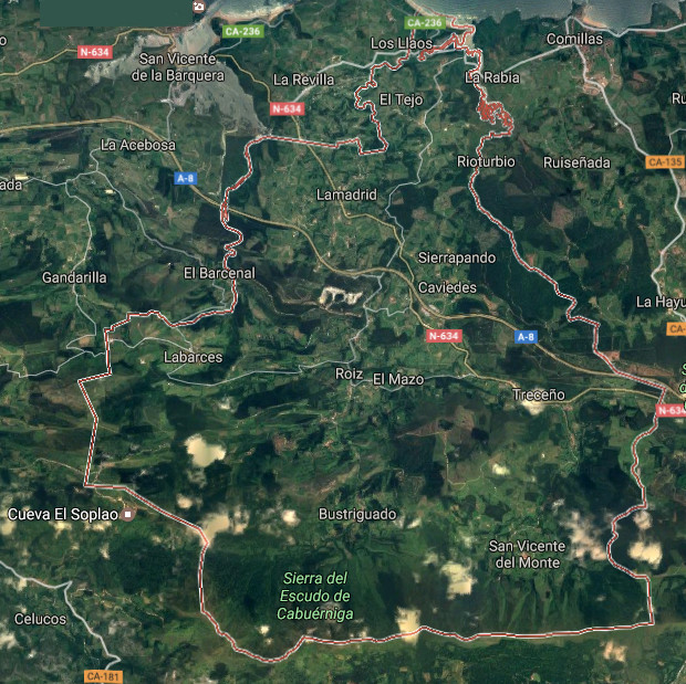
![]() Valdáliga es un municipio situado en la costa occidental de Cantabria. Habitado desde tiempos remotos, han sido encontrados yacimientos arqueológicos con 20.000 años de antigüedad en la localidad de Roiz, llamados los Abrigos de Roiz. Forman parte de la municipalidad las siguientes localidades: Caviedes, Labarces, Lamadrid, San Vicente del Monte, Treceño, Movellán, La Cocina, La Vega y Roiz; capital del territorio.
Valdáliga es un municipio situado en la costa occidental de Cantabria. Habitado desde tiempos remotos, han sido encontrados yacimientos arqueológicos con 20.000 años de antigüedad en la localidad de Roiz, llamados los Abrigos de Roiz. Forman parte de la municipalidad las siguientes localidades: Caviedes, Labarces, Lamadrid, San Vicente del Monte, Treceño, Movellán, La Cocina, La Vega y Roiz; capital del territorio.
El patrimonio arquitectónico de la zona destaca por sus construcciones montañesas presentes en todas la localidades. La naturaleza, el origen agrícola y ganadero y la localización marcan el diseño y la funcionalidad de estos edificios. La Ermita de la Virgen del Endrinal en Labarces es una muestra del arte sacro perteneciente al periodo gótico. Las construcciones señoriales del siglo XVII atestiguan el desarrollo de la villa, algunos ejemplos son: la Casa-Torre de los Caviedes, la Casa-Torre de los Vega o la Casona de la Salceda. La ampliación del patrimonio continua hasta el barroco con palacios montañeses como el de Los Vía o el de Los Vélez-Escalante.
La riqueza natural de la comarca es variada. Siendo una zona de media montaña, alterna valles y zonas montañosas como la Sierra del Escudo de Cabuérniga o el Monte Corona, emplazamientos compartidos con otros municipios. El reducido litoral que conecta el mar con Valdáliga es singular. La playa de Oyambre, localizada dentro del Parque Natural de Oyambre, se ubica en un entorno idílico, pues a su belleza se suma el modelado que el tiempo ha realizado sobre su piel. El caminar relajado sobre su arenal transmitirá sensaciones que describen características de su naturaleza salvaje, propia.
![]() Valdáliga is a municipality placed in the western coast of Cantabria. Inhabited from remote times, archaeological deposits have been found with 20.000 years of antiquity in Roiz’s locality, called Abrigos of Roiz . The following localities form a part of the municipality: Caviedes, Labarces, Lamadrid, San Vicente of the Monte, Treceño, Movellán, La Cocina, La Vega and Roiz; the capital of the territory.
Valdáliga is a municipality placed in the western coast of Cantabria. Inhabited from remote times, archaeological deposits have been found with 20.000 years of antiquity in Roiz’s locality, called Abrigos of Roiz . The following localities form a part of the municipality: Caviedes, Labarces, Lamadrid, San Vicente of the Monte, Treceño, Movellán, La Cocina, La Vega and Roiz; the capital of the territory.
The architectural heritage of the zone emphasizes for its highland constructions present in all the localidades. The nature, the agricultural and cattle origin and the location mark the design and the functionality of these buildings. The Hermitage of the Virgin of the Endrinal in Labarces is a sample of the sacred art belonging to the Gothic period. The lordly constructions of the 17th century testify the development of the villa, some examples are: the Tower-House Toasts of Caviedes, the Tower-House of Vega or the Casona de la Salceda. The extension of the heritage continues up to the baroque with highland palaces as that of The Vía or that of The Vélez-Escalante.
The natural wealth of the region is varied. Being a half mountain zone, it alternates valleys and mountainous zones as the Mountain Range of Escudo de Cabuérniga or the Mount Coronas, emplacements shared with other municipalities. The limited littoral that connects the Sea with Valdáliga is singular. The beach of Oyambre, located inside Oyambre’s Nature Reserve, is located in an idyllic environment, since to its beauty there adds the shaped one that the time has realized on its skin. The placid walk on its sandbank will transmit sensations that describe characteristics of its wild, own nature.
![]()

Valdáliga, village
Comillas, villa
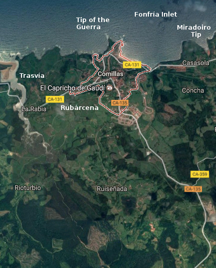
![]() Comillas, villa y municipio situado en la costa occidental de Cantabria, dispone de un variado litoral con irregular forma. Los cabos Punta de la Guerra y Punta del Miradoiro contiene la Ensenada de Fonfría. EL puerto pesquero, la playa de Comillas y los acantilados son algunos de los atractivos de su costa que junto con el Paseo Marítimo, redondean una bella imagen de gratificante contemplación en cualquiera de los puntos de su recorrido. Las localidades que componen el municipio son: La Rabia, Rioturbio, Rubárcena, Ruiseñada, Trasvía y Comillas; capital de la circunscripción.
Comillas, villa y municipio situado en la costa occidental de Cantabria, dispone de un variado litoral con irregular forma. Los cabos Punta de la Guerra y Punta del Miradoiro contiene la Ensenada de Fonfría. EL puerto pesquero, la playa de Comillas y los acantilados son algunos de los atractivos de su costa que junto con el Paseo Marítimo, redondean una bella imagen de gratificante contemplación en cualquiera de los puntos de su recorrido. Las localidades que componen el municipio son: La Rabia, Rioturbio, Rubárcena, Ruiseñada, Trasvía y Comillas; capital de la circunscripción.
La abundancia de cuevas, debido a su orografía, que cuentan con pinturas y útiles dan testimonio de la presencia de pobladores desde la prehistoria. Destacan la Cueva de la Meaza, la Cueva de Portillo y el castro de la Peña del Castillo. La Mina Numa situdada en la localidad de Ruiseñada, explotada desde la antiguedad conserva restos de la época romana. Los documentos más antiguos que asientan la historia de Comillas datan del siglo XI, a partir de aquí se entremezcla el desarrollo de la villa, las artes, oficios y su desarrollo arquitectónico jalonando siglo a siglo. La industria ballenera, la torre de Garcilaso I de la Vega (conocida como el Torreón), el desarrollo del puerto, la Iglesia parroquial que cuenta con reconstrucciones en diferentes épocas, son algunos de los episodios históricos que se han escrito en la villa de Comillas.
En la actualidad la arquitectura modernista realizada en el siglo XIX constituye la muestra más visible de su patrimonio. El Palacio de Sobrellano, El Capricho de Gaudí y La Universidad Pontificia de Comillas son las singularidades que coronan la belleza asentada desde el pavimento de sus calles, colinas y prados, la particular configuración de su territorio que dio origen a su nombre.
![]() Comillas, village and municipality placed in the western coast of Cantabria, has a varied littoral with irregular form. The capes: Tip of the Guerra and Tip of the Miradoiro contains the Inlet of Fonfría. The fishing port, the beach of Comillas and the cliffs are some of the attractives of its coast, that combined with the Maritime Promenade, round up a beautiful image of gratifying contemplation in any of the points of its tour. The localities that compose the municipality are: La Rabia, Rioturbio, Rubárcena, Ruiseñada, Trasvía and Comillas; capital of the circumscription.
Comillas, village and municipality placed in the western coast of Cantabria, has a varied littoral with irregular form. The capes: Tip of the Guerra and Tip of the Miradoiro contains the Inlet of Fonfría. The fishing port, the beach of Comillas and the cliffs are some of the attractives of its coast, that combined with the Maritime Promenade, round up a beautiful image of gratifying contemplation in any of the points of its tour. The localities that compose the municipality are: La Rabia, Rioturbio, Rubárcena, Ruiseñada, Trasvía and Comillas; capital of the circumscription.
The abundance of caves, due to its orography, which possess paintings and useful that give testimony of the settlers’ presence from the prehistory. Stand out the Cave of the Meaza, the Cave of Portillo and the Celtic fortification of the Peña del Castillo. The Mine Numa placed in Ruiseñada’s locality, exploited since anciente times preserv rests of the Roman epoch. The most former documents that agree the history of Comillas date back to the 11th century, from here there intermingles the development of the villa, the arts, trades and its architectural development marking century a century. The whaler industry, the tower of Garcilaso I de la Vega (known as the Torreón), the development of the port, the parochial Church that possesses reconstructions in different epochs, are some of the historical episodes that have been written in the village of Comillas.
At present, the modernist architecture realized in the 19th century constitutes the most visible sample of its heritage. The Palace of Sobrellano, The Caprice of Gaudí and The University Pontificia of Comillas are the singularities that crown the beauty seated from the pavement of its streets, hills and meadows, the particular configuration of the territory that gave origin to its name.
![]()

Comillas, village
Cobreces, villa
![]()
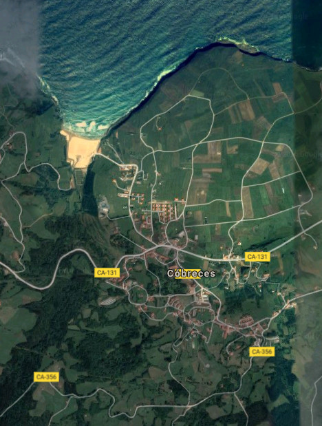
Cóbreces es una pequeña localidad costera perteneciente al municipio de Alfoz de Lloredo. Emplazado en la costa occidental de Cantabria, su núcleo urbano dista apenas 500 metros de la playa de Luaña. La configuración del litoral, en esta zona, abre una ensenada que termina desembocando en el arenal. El entorno acompaña a su singularidad. Conserva un estado natural semisalvaje, rodeado de praderas, colinas,acantilados y bosques.
Los orígenes de la villa se remontan al siglo X. El testimonio y registro de su historia es el patrimonio arquitectónico. La arquitectura civil destaca con edificios como el Palacio de Villegas, Casal de Castro y el Instituto Agrícola Práctico Quirós; edificio construido en el siglo XX sobre la antigua casa del linaje de Quirós. La arquitectura religiosa refleja los pasos de la historia y el camino de los linajes. El lugar que ocupaba el antiguo monasterio de San Félix del siglo X es el actual emplazamiento de la Iglesia de San Felices de Mies, del siglo XV. La Abadía de Santa María de Viaceli, la Ermita de Santa Ana o La Iglesia de San Pedro Ad vincula son otros ejemplos de su riqueza.
La costa acantilada e irregular de Cóbreces descubre en su trazado varias zonas a modo de mirador. La altura del litoral, la naturaleza que puebla de praderas hasta su borde y el Mar Cantábrico son algunos de los ingredientes que producen un lugar idílico e idóneo para disfrutar del esparcimiento. El acantilado de Bolao es una muestra de su costa. El acceso por carretera comarcal desemboca en un pequeño aparcamiento campestre. A 200 metros aparecen restos de los antiguos molinos de marea, el sonido del océano es proyectado hacia tierra y las lastras que contiene la formación, presentan el espacio a la vista.
![]() Cóbreces is an small coastal locality belonging to the municipality of Alfoz de Lloredo. Located on the western coast of Cantabria, its urban core is far scarcely 500 meters of Luaña’s beach. The configuration of the littoral, in this zone, opens an inlet that finally ends in the sandbank. The environment accompanies to its singularity. There preserves a semi-wild nature, surrounded with meadows, hills, cliffs and forests.
Cóbreces is an small coastal locality belonging to the municipality of Alfoz de Lloredo. Located on the western coast of Cantabria, its urban core is far scarcely 500 meters of Luaña’s beach. The configuration of the littoral, in this zone, opens an inlet that finally ends in the sandbank. The environment accompanies to its singularity. There preserves a semi-wild nature, surrounded with meadows, hills, cliffs and forests.
The origins of the villa go back to the 10th century. Testimony and record of its history is the architectural heritage. The civil architecture stands out with buildings as Villegas’s Palace, Casal de Castro and the Agricultural Practical Institute Quirós; building constructed in the 20th century over the former house of Quirós’s lineage. The religious architecture reflects the steps of the history and the way of the lineages. The place that was occupying San Félix’s former monastery of the 10th century is the current emplacement of San Felices de Mies Church, of the 15th century. The Abbey of Santa Maria de Viaceli, the Hermitage of Holy Ana or San Pedro Ad vincula Church are other examples of its wealth.
The steep and irregular coast of Cóbreces discovers in its tracing several zones as viewing-point. The height of the littoral, the nature that populates with meadows up to its edge and the Cantabrian Sea are some of the ingredients that produce an idyllic and suitable place to enjoy the scattering. Bolao’s cliff is a sample of its coast. The access, by regional road, ends in a small rural parking. In 200 meters there appear remains of the former mills of tide, the sound of the ocean is projected towards land and the flagstones that contains the formation , present the space at sight.
![]()

Cobreces, village
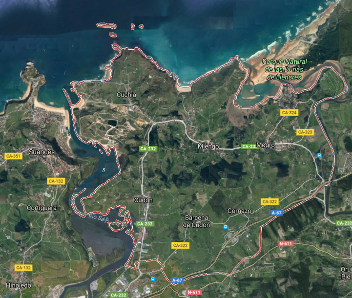
Miengo, villa
![]() Miengo es un municipio y localidad situado en la costa central de Cantabria. Limitando al oeste con Suances y al este con Santa Cruz de Bezana, se encuentra en las proximidades de la ciudad de Santander. Pertenecen a su municipalidad las siguientes localidades: Barcena de Cudón, Cuchía, Cudón, Gornazo, Mogro y Miengo; capital del ayuntamiento.
Miengo es un municipio y localidad situado en la costa central de Cantabria. Limitando al oeste con Suances y al este con Santa Cruz de Bezana, se encuentra en las proximidades de la ciudad de Santander. Pertenecen a su municipalidad las siguientes localidades: Barcena de Cudón, Cuchía, Cudón, Gornazo, Mogro y Miengo; capital del ayuntamiento.
Su emplazamiento, ubicado en una zona de transito entre dos grandes ciudades; Santander y Torrelavega, lo comunican por carretera nacional y autovía, existiendo además líneas regulares de trenes y autobuses hacia ambas urbes. Los atractivos turísticos cercanos no merman los propios del municipio que debido a su orografía y costa tintan la mirada y la estancia de un singular tono. Las playas de Cuchía, Los Caballos, Usgo, Robayera y Usil, distribuidas a lo largo del litoral menicense, se entremezclan con pequeñas calas, acantilados e islas. El irregular dibujo costero que dispone multitud de orientaciones en sus localizaciones y la naturaleza salvaje del Mar Cantábrico, diseñan paisajes erosionados; esculpidos a través del tiempo. Las islas de: los Conejos, Pasiega, Casilda, Segunda y Solita forman parte de su patrimonio y dan testimonio de la arcaica línea de costa.
El territorio que avanza tierra adentro, es acotado por el Río Saja en el extremo Oeste y el Río Pas en el Este. La Ría de Mogro, desembocadura del Pas, nutre y amplía el Parque Natural de Las Dunas de Liencres. Otro ingrediente de la villa es el patrimonio arquitectónico que se divide entre construcciones religiosas, como el Santuario de la Virgen del Monte o la Iglesia de San Juan Bautista, y construcciones civiles; destacando el Palacio de los Herrera o de la Dehesa.
![]() Miengo is a municipality and locality placed in the central coast of Cantabria. Delimiting in the western part with Suances and Santa Curz de Bezana in the eastern side, it is in the proximities of the city of Santander. The following localities belong to its township: Barcena de Cudón, Cuchía, Cudón, Gornazo, Mogro and Miengo; the capital of the town.
Miengo is a municipality and locality placed in the central coast of Cantabria. Delimiting in the western part with Suances and Santa Curz de Bezana in the eastern side, it is in the proximities of the city of Santander. The following localities belong to its township: Barcena de Cudón, Cuchía, Cudón, Gornazo, Mogro and Miengo; the capital of the town.
Its emplacement located in a zone of traffic between two big cities; Santander and Torrelavega, communicates it by national road and highway, existing in addition regular lines of trains and buses towards both cities. The tourist nearby attractions do not reduce the own ones of the municipality that due to its orography and coast dye the look and the stay of a singular tone. The beaches of Cuchía, Los Caballos, Usgo, Robayera and Usil distributed along the littoral menicense, intermingle with small coves, cliffs and islands. The irregular coastal drawing that arranges multitude of orientations in its locations and the wild nature of the Cantabrian Sea, design eroded landscapes; sculpted across the time. The islands of: Los Conejos, Pasiega, Casilda, Segunda and Solita form a part of its heritage and give testimony of the archaic coastline.
The territory that advances land in, is annotated by the Saja River in the extreme West and the Pas River in the East. The Stuary of Mogro, river mouth of the Pas, nourishes and extends the Nature reserve of Liencres’s Dunes. Another ingredient of the villa is the architectural heritage that is divided between religious constructions, as the Sanctuary of the Virgin del Monte or the Church of San Juan Bautista, and civil constructions; emphasizing the Palace of the Herrera or the Dehesa.
![]()

Miengo, village