Isla de Santa Marina (Santa Marina Island), Acceso

Icono. Icon. Santa Marina Island La Isla de Santa Marina tiene un acceso a través de la playa de los Tranquilos. Desde el parking se divisa la Isla de Santa Marina y la playa. Se accede a la playa por una escalera de madera y de ahí se llega hasta la Isla.

Santa Marina Island, access

Icono. Icon. Santa Marina Island Santa Marina Island has a access through the beach «Los Tranquilos». From the parking area you can see the Island of Santa Marina and that small beach. You can access to the beach through a wooden staircase. Then you will be able to reach the Island.

Icono español-inglés. Icon Spanish-English. Santa Marina Island Acceso/Surf Access

Acceso Isla de Santa Marina.

Icon close Sponsor

Share

Isla de Santa Marina, localización

Icono Español. Icon Spanish La Isla de Santa Marina está situada enfrente de la costa de Loredo. Se encuentra en la parte más oriental de su extenso arenal, donde ya finalizan las playas de Loredo y empiezan sus acantilados. Se puede llegar a Santa Marina desde Oviedo, Palencia, Santander o desde Bilbao. Ambos trayectos finalizan en la misma carretera nacional que atreviesa el municipio de Loredo. El final del trazado se prolonga más allá del punto señalizado en la guía. Girando a la izquierda, continuando hasta encontrar al final de la carretera donde aparecerá la Isla de Santa Marina.

Santa Marina Island, Localization

Icono Inglés. Icon English Santa Marina Island is placed opposite the Loredo coast. It is in the most oriental part of Loredo beach, where the beaches of Loredo are already finish and begin its cliffs. It is possible to come to Santa Marina Island from Oviedo, Palencia, Santander or from Bilbao. Both ways finish in the same national road that go across the municipality of Loredo. The end of the tracing extends beyond the point that is set in the guide. Turning to the left side, continuing up to finding at the end of the road where the island will appear Santa Marina Island.

Icono Español-Inglés. Icon Spanish-English Localización/Localization

Oviedo, Santa Marina : LocalizationPalencia, Santa Marina: LocalizationBilbao, Santa Marina: LocalizationSantander, Santa Marina: localization

Icon close Sponsor

Share

Langre, acceso a la playa

Icono Español. Icon Spanish La playa de Langre tiene dos vías de acceso. La primera vía está situada a la izquierda en el mapa, da entrada a la playa más pequeña de Langre, de las dos que componen el arenal. Es una zona ideal para el baño. El segundo acceso desemboca en la playa grande, que tiene unas condiciones especiales para practicar Surf.

Langre, access to the beach

Icono Inglés. Icon English The Langre beach has two access routes. The first route placed to the left in the map, leads to the smallest beach of Langre, one of the two beaches that are in the zone. It is an ideal area for swimming. The second way ends in the big beach. This beach has ideal conditions to Surfing.

Langre, Icono Español-Inglés. Icon Spanish-English. Acceso/Beach Access

Langre, acceso/access

Langre, Icon close Sponsor

Share

Playa de Berria, zonas hábiles

Icono Español. Icon, Spanish 
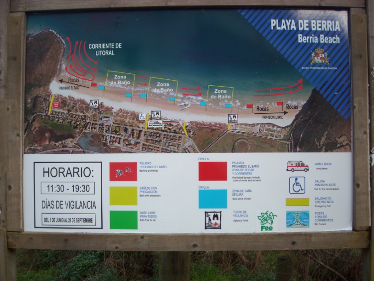
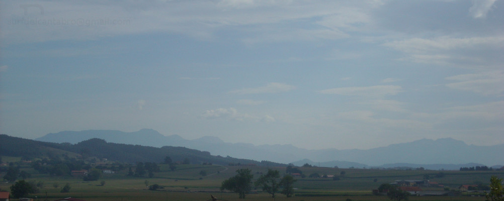
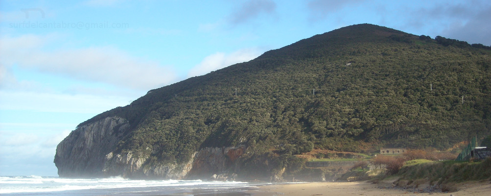
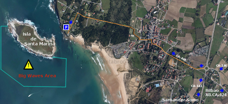
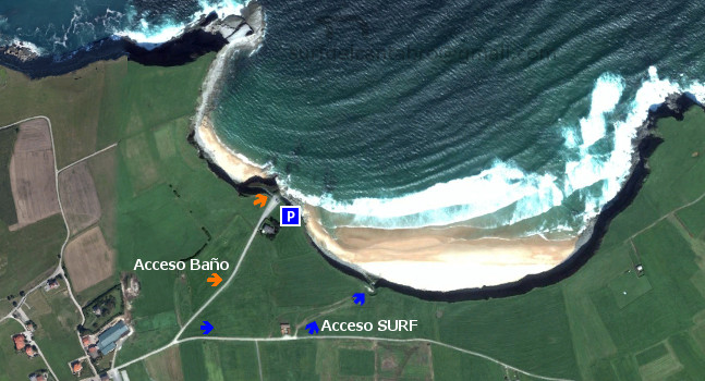
La Playa de Berria tiene una longitud de 2200 metros. Es una joya de costa Cántabra, ya que a su contexto natural idílico,  se le añade la naturaleza cambiante de sus aguas según la zona de la playa de la que se trate, por la proximidad a las rocas o las fuertes corrientes presentes. Por todo esto, el Ayuntamiento de Santoña ha publicado, a pie de playa en Berria, unos mapas fotográficos, trípticos con toda la información de la Playa de Berria y sus aguas. Es útil prestar atención a ese tipo de información si vamos a practicar surf o realizar otras actividades en las mejores condiciones, de forma segura. Aquí dejo una fotografía de uno de estos carteles.

Berria beach, working areas

Icono Inglés. Icon, English Berria Beach has a length of 2200 meters. It is a jewel of the Cantabrian coast, because to its natural idyllic context, is added the changing nature of their waters according to the area of the beach, the proximity to the rocks or the strong currents. Due to this, the Town Hall of Santoña has published, on the beachfront of Berria, some photographic maps and brochures with all the information about the beach of Berria, and its waters. It is useful to pay attention to that kind of information if we are going to play surf or another activities in the best conditions, safely. Here is a photograph of one of these posters.

Separador. DividerIcono Español-Inglés. Icon Spanish-English
Playa de Berria, zonas hábiles. Berria beach, working areasIcono separador. Icon divider

Icon close Sponsor

Share

Berria, origen. Significado del nombre

Icono. Icon El origen del nombre de Berria, playa localizada en Santoña, proviene del término «berro», que designa una planta que crece en lugares pantanosos. Al sur de la playa de Berria se encuentran las Marismas de Santoña, cuya denominación actual es: Parque Natural de las Marismas de Santoña, Victoria y Joyel. Esta denominación fue otorgada por la Jefatura del Estado en marzo de 1992. Sin embargo las marismas ya existían anteriormente. El berro continúa presente en las marismas. En el siglo XVII está registrado el nombre de Playa de Berrio, con la introducción de la «i» dentro de la palabra por derivación lingüistica montañesa. La playa de Berria pertenece al municipio de Santoña, siendo su asentamiento anterior a la romanización.

Berria, origin. Meaning of the name

Icono. Icon The origin of the name «Berria», beach located in Santoña, comes from the term «berro», which refers to a plant that grows in swampy places. South of Berria Beach are the Marshes of Santoña, which is currently called «Natural Park of the Marshes of Santoña, Victoria and Joyel». This name was granted, by the Head of State (Spain), in March 1992. However the marshes already existed previously. Today in these marshes can be found this plant; the watercress («berro»). Berrio Beach name, with the introduction of the ‘i’ in mountain word derivatively Linguistics is registered in the 17TH century. Berria beach belongs to the municipality of Santoña, being its history previous to the Roman conquest.

Icon close Sponsor

Share