Playa de Portio, acceso

Icono. Icon La Playa de Portio está situada en la localidad de Liencres, dentro del municipio de Piélagos. Es una pequeña playa localizada en el interior de una ensenada de gran belleza paisajistica, geológica y submarina. El fondo rocoso del entorno y las fuertes corrientes presentes en la zona aconsejan extremar la precaución. La llegada a la playa atraviesa Liencres . Tiene un pequeño aparcamiento ubicado en el último tramo que conduce al arenal.

Portio Beach, access

Icono. Icon The Beach of Portio is placed in the locality of Liencres, in the municipality of Piélagos. It is a small beach located inside an inlet. The area has a beauty landscape, geological and submarine. The rocky bottom of the environment and the strong present currents in the zone advise us to carry to extremes the precaution. The arrival to the beach crosses Liencres. It has a small parking located in the last section that he leads to the sandbank.

Icono español-inglés. Icon Spanish-English Acceso/Access

Access Portio Beach

Icon close Sponsor

Share

Playa de Portio, localización

Icono. Icon La playa de Portio está situada en la localidad de Liencres, perteneciente al municipio de Piélagos. Es una playa pequeña, ubicada dentro de una ensenada, ideal para practicar submarinismo. Todos los trayectos se hacen por autovía, finalizando por la carretera nacional CA-231. Se muestran a continuación como puntos de partida Oviedo, Palencia, Santander y Bilbao.

Beach of Portio, localization

Icono. Icon The beach of Portio is placed in the locality of Liencres, belonging to the municipality of Piélagos. It is a small beach, located inside and inlert, ideal to practise scuba diving. All the journeys are done by motorway, finishing through the national road CA-231. Shown below as starting points Oviedo, Palencia, Santander and Bilbao.

Icono español-inglés. Icon Spanish-English Localización/Localization

Oviedo, Playa de Portio , beach: localizationPalencia, Playa de Portio , beach: localizationBilbao, Playa de Portio: localizationSantander, Playa de Portio , beach: localization

Icon close Sponsor

Share

Playa de Robayera, acceso

Icono Español. Icon Spanish Se accede a la Playa de Robayera por la carretera nacional CA-232, a través del municipio de Miengo. Al final del Barrio de Poo se encuentra la Playa de Robayera. Podemos entrar a la playa por la parte superior, estacionando el vehículo en el ascén de la carretera y siguiendo un sendero. La otra entrada se hace por la parte inferior, introduciendo el vehículo por un camino de tierra y estacionando en una pequeña zona a modo de parking. Después seguiremos el sendero que bordea las fincas hasta la playa.

Aviso : esta playa es una de las más peligrosas de Cantabria por sus fuertes corrientes y su fondo de roca. Se requiere un alto nivel de Surf y una gran condición física.

Playa de Robayera, access

Icono Inglés. Icon English You can go to the Beach of Robayera by national highway CA-232, through the municipality of Miengo. At the end of the Neighborhood of Poo is located the Beach of Robayera. You may go to the beach from the top. The vehicle should be parked in the ditch of the road, Then you have to follow a path. The other entrance is at the bottom, we have to enter with the vehicle on a dirt road and stationing it in a small area by way of parking. Afterwards, we will continue the path that borders the properties up to the beach.

Warning : this beach is one of the most dangerous places of Cantabria by its strong currents and its fund of rock. This requires a high level of surfing and high physical condition.

Icono Español-Inglés. Icon Spanish-English Acceso/Access

Beach Access: Playa de Robayera

Icon close Sponsor

Share

Canallave (Liencres). Acceso/Access

Icono Español. Icon Spanish La Playa de Canallave está situada en la localidad de Liencres. Tiene acceso desde el este por Santander, atravesando la ciudad y las localidades de San Román, Liencres y Soto de la Marina. Finaliza esta ruta por la carretera nacional CA-231. El acceso desde el oeste por Oviedo se realiza por autovía, finalizando el trayecto por la carretera nacional CA-231. El acceso desde Bilbao comienza por el este y finaliza por la parte oeste de la carretera nacional CA-231. Canallave tiene un acceso principal que da directamente a la playa, situado en la zona derecha de aparcamientos. Cuenta con un segundo acceso a través del aparcamiento de la izquierda, cruzando una pequeña cala con fondo rocoso.

Icono Inglés. Icon English Canallave Beach is placed in the locality of Liencres. It has access from the east by Santander, crossing part of the city and the towns of San Roman, Liencres and Soto of the Marina. The end of this travel runs through the national roadCA-231. The access from the west by Oviedo is performed by motorway, ending the journey from the national roadCA-231. The access from Bilbao begins on the east and ends in the western part of the national road CA-231. Canallave has a principal access that gives directly to the beach and is placed in the right zone of parkings. The beach possesses the second access across the parking of the left side, through a small cove with rocky bottom.

Icono Español-Inglés. Icon Spanish-English Acceso/Access


Canallave: access

Icon close Sponsor

Share

De Liencres a Portio. Ruta de senderismo

Icono Español. Icon Spanish. De Liencres a Portio 
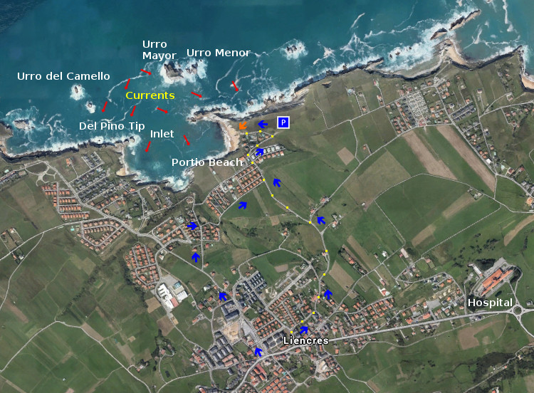
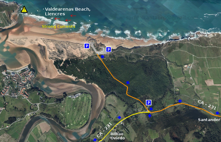
La Playa de Valdearenas está ubicada en el municipio de Liencres y es conocida también por el nombre de su localidad. Los accesos a la playa cuentan con dos amplias zonas de aparcamiento. El parking situado más a la derecha da acceso a una carretera comarcal que se extiende a lo largo de 3 km hasta llegar a la Playa de Portio.

Allí empieza una ruta que avanza paralela a la costa. Esta zona es una parte de la Costa Quebrada, que va desde las Dunas de Liencres hasta la Península de la Magdalena, en Santander. El camino lo podemos realizar por la carretera. Tiene esta un escaso transito de vehículos fuera de la estación estival. La otra opción consiste en seguir un pequeño sendero marcado en el recorrido por el paso de los caminantes y que se localiza cercano a los acantilados.

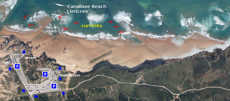
El primer tramo transita cercano a una parte del Pinar de Liencres. En el pinar contrasta la altura de su árboles y sus colores con el tono cobrizo del suelo del bosque. Lecho formado por las hojas secas de los pinos. Esta imagen provoca la reminiscencia de una parte del antiguo bosque cántabro, presente en todo el territorio hasta llegar al mar. Hay pequeñas cuestas y suaves descensos que sirven de calentamiento para el resto de la ruta. Al otro lado se encuentra la Playa de Canallave. De pequeña extensión, cuenta con un arenal amplio salpicado de rocas modeladas por el oleaje. Comienza aquí el disfrute del paisaje y la imaginación.

La segunda parte del recorrido se hace a campo abierto. Rodeado de verde pradera hasta donde alcanza la vista. Mirando los prados, y siguiendo su línea, encontramos el Monte Tolio que acota esta semillanura. Siguiendo el sendero aparece un descenso que finaliza casi a nivel del mar. Desde este punto asoma una parte de la Playa del Madero. Continuando, después de una ligera cuesta, empieza la pedregosa entrada a esta especial cala. Colocada en el trazo interno del acantilado que la mar ha esculpido y delimitado del oleaje por una pared vertical de roca antigua. Para finalizar este tramo el camino elevado nos conducirá hasta la Playa de Somocuevas. Tiene un dificultoso acceso y la rodea un marco único que baña la playa por este y oeste.

El último tramo se realiza recorriendo el borde de la ensenada que baña las playas y calas que en ella existen. La Playa de las Cerrias se va acercando a cada paso. Descubre esta pequeña cala una zona de baño colocada dentro de la ensenada. 200 metros después está Llatas. La cala que muestra, por efecto de la erosión del mar, la base del acantilado. Finalmente llegamos a la Playa de Portio. La de mayor extensión y protegida por un respaldo rocoso en forma de media luna, vestigio de la forma prehistórica de esta parte de la costa.

Consejo : tener precaución.

Liencres to Portio. Trekking route

Icono Inglés. Icon English Valdearenas Beach is located in the municipality of Liencres and is also known by the name of its locality. The accesses to the beach are equipped with two large parking areas. From the parking that is located more to the right gives access to a county road that stretches along 3 km until you reach the Portio beach.

There begins a path that moves parallel to the coast. This area is a part of The Quebrada Coast, that goes from The Dunes of Liencres up to the Peninsula de la Magdalena, in Santander. The route can be perform through the road. It has a little transit of vehicles outside of the summer season. The other option is to follow a small trail marked on the route through the passage of the walkers and that is located close to the cliffs.

The first stage passes close to a part of the Pinar de Liencres. In the Pine forest contrasts the height of the trees and their colors with the coppery hue of the forest floor. The bed is formed by the dry leaves of the pines. This image is reminiscent of one part of the old cantabrian forest, present in the whole territory until reaching the sea. There are small hills and mild reductions that serve as a warm-up for the rest of the path. On the other side is placed Canallave Beach. It has a small extension, arenal account with a large rock-strewn modeled by the swell. Starts here the enjoyment of the scenery and the imagination.

The second part of the trip is done in the open countryside. Surrounded by green meadow as far as the eye can see. Looking the meadows, and following its line, we find the Mount Tolio limiting this plain. Continuing the path that end lower, almost at sea level. From this point overlooking a part of the Madero Beah. Then a slight hill begins the pebbled entrance to this special cove. Positioned in the stroke internal of the cliff that the sea has sculpted and it is protected of the surf by a vertical wall of old rock. To finish this stretch of the elevated road will lead us to the Somocuevas Beach. Has a difficult access and the surrounds a single framework that bathes the beach by east and west.

The last stretch is realized covering the rim of the big cove that bathes the beaches that in it exist. The
Beach of the Cerrias is approaching every step. There discovers this small cove an area of bath placed inside the big cove. 200 meters later is Llatas. The cove that shows, for effect of the erosion of the sea, the base of the cliff. Finally we come to the Beach of Portio. That of major extension and protected by a rocky support in the shape of half moon, trace of the prehistoric form of this part of the coast.

Advice: take caution.

icono separador forja, aperturaicono español-inglés en horizontalLiencres,Portio: routeicono separador forja, cierre

Icon close Sponsor

Share

Valdearenas ,Liencres; acceso

Icono Español. Icon Spanish La Playa de Valdearenas, También conocida como Liencres, tiene acceso desde el este por Santander, atravesando una ruta pintoresca que cruza parte de la ciudad y las localidades de San Román, Liencres y Soto de la Marina. Finaliza esta ruta por la carretera nacional CA-231. El acceso desde el oeste por Oviedo se realiza por autovía, finalizando el trayecto por la carretera nacional CA-231. El acceso desde Bilbao comienza por el este y finaliza por la parte oeste de la carretera nacional CA-231.

Valdearenas, Liencres; access

Icono Inglés. Icon English Valdearenas Beach, also known as Liencres, has access from the east by Santander, going through a picturesque route that crosses part of the city and the towns of San Roman, Liencres and Soto of the Marina. The end of this travel runs through from the national highway CA-231. The access from the west by Oviedo is performed by motorway, ending the journey from the national highway CA-231. The access from Bilbao begins on the east and ends in the western part of the national highway CA-231.

Icono Español-Inglés. Icon Spanish-English Acceso/Beach Access

Acceso:Valdearenas,Liencres

Icon close Sponsor

Share

Playa de Valdearenas, Liencres; Localización

Icono Español. Icon Spanish La Playa de Valdearenas está situada en la localidad de Liencres, perteneciente al municipio de Piélagos. Esta playa también se conoce con el nombre de su localidad, Liencres. A la Playa de Valdearenas se puede llegar desde Oviedo, Palencia, Santander y Bilbao; como puntos de partida, todos los demás orígenes atraviesan por uno o varios de estos puntos. La llegada a las playas de Liencres no es está indicada en las guías oficiales, es por ello que la ruta finaliza en el Barrio Callejo de liencres. Llegando desde Oviedo encontramos la entrada a las playas antes de llegar al Barrio Callejo. Desde los demás puntos de partida debemos continuar la carratera hasta llegar al Parque natural de las Dunas de Liencres. La entrada esta bien señalizada.

Valdearenas Beach, Liencres; Localization

Icono Inglés. Icon English Valdearenas Beach is located in the town of Liencres, belonging to the municipality of Piélagos. This beach is also known by the name of its locality, Liencres. To the beach of Valdearenas can be reached from Oviedo, Palencia, Santander and Bilbao; as points of departure, all other origins run through one or more of these points. The arrival to Liencres’s beaches is not is indicated in the official guides, is for it that the route finishes in the Neighborhood Callejo of liencres. Coming from Oviedo we find the entry to the beaches before arriving to the Neighborhood Callejo. From other points of item we must continue the road up to coming to the Nature Reserve of Liencres’s Dunes. The entry is well indicated.

Icono Español-Inglés. Icon Spanish-English Localización/Localization

Oviedo, Playa de Valdearenas; Liencres: LocalizationPalencia, Playa de Valdearenas; Liencres : LocalizationBilbao, Playa de Valdearenas; Liencres: LocalizationSantander, Playa de Valdearenas; Liencres; Localization

Share