Isla de Santa Marina (Santa Marina Island), Acceso

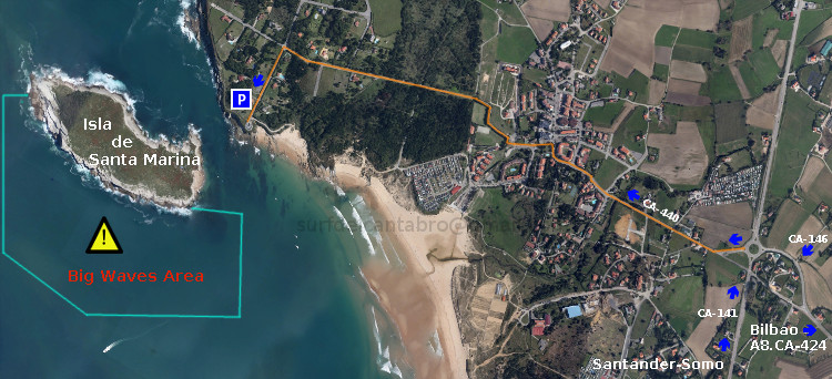
Icono. Icon. Santa Marina Island La Isla de Santa Marina tiene un acceso a través de la playa de los Tranquilos. Desde el parking se divisa la Isla de Santa Marina y la playa. Se accede a la playa por una escalera de madera y de ahí se llega hasta la Isla.

Santa Marina Island, access

Icono. Icon. Santa Marina Island Santa Marina Island has a access through the beach «Los Tranquilos». From the parking area you can see the Island of Santa Marina and that small beach. You can access to the beach through a wooden staircase. Then you will be able to reach the Island.

Icono español-inglés. Icon Spanish-English. Santa Marina Island Acceso/Surf Access

Acceso Isla de Santa Marina.

Icon close Sponsor

Share

Isla de Santa Marina, localización

Icono Español. Icon Spanish La Isla de Santa Marina está situada enfrente de la costa de Loredo. Se encuentra en la parte más oriental de su extenso arenal, donde ya finalizan las playas de Loredo y empiezan sus acantilados. Se puede llegar a Santa Marina desde Oviedo, Palencia, Santander o desde Bilbao. Ambos trayectos finalizan en la misma carretera nacional que atreviesa el municipio de Loredo. El final del trazado se prolonga más allá del punto señalizado en la guía. Girando a la izquierda, continuando hasta encontrar al final de la carretera donde aparecerá la Isla de Santa Marina.

Santa Marina Island, Localization

Icono Inglés. Icon English Santa Marina Island is placed opposite the Loredo coast. It is in the most oriental part of Loredo beach, where the beaches of Loredo are already finish and begin its cliffs. It is possible to come to Santa Marina Island from Oviedo, Palencia, Santander or from Bilbao. Both ways finish in the same national road that go across the municipality of Loredo. The end of the tracing extends beyond the point that is set in the guide. Turning to the left side, continuing up to finding at the end of the road where the island will appear Santa Marina Island.

Icono Español-Inglés. Icon Spanish-English Localización/Localization

Oviedo, Santa Marina : LocalizationPalencia, Santa Marina: LocalizationBilbao, Santa Marina: LocalizationSantander, Santa Marina: localization

Icon close Sponsor

Share

Langre, acceso a la playa

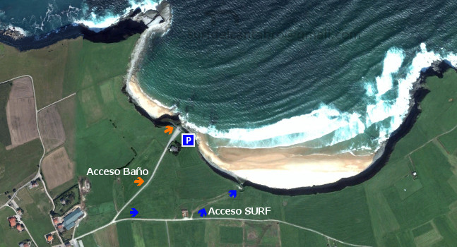
Icono Español. Icon Spanish La playa de Langre tiene dos vías de acceso. La primera vía está situada a la izquierda en el mapa, da entrada a la playa más pequeña de Langre, de las dos que componen el arenal. Es una zona ideal para el baño. El segundo acceso desemboca en la playa grande, que tiene unas condiciones especiales para practicar Surf.

Langre, access to the beach

Icono Inglés. Icon English The Langre beach has two access routes. The first route placed to the left in the map, leads to the smallest beach of Langre, one of the two beaches that are in the zone. It is an ideal area for swimming. The second way ends in the big beach. This beach has ideal conditions to Surfing.

Langre, Icono Español-Inglés. Icon Spanish-English. Acceso/Beach Access

Langre, acceso/access

Langre, Icon close Sponsor

Share

Playa de Berria, zonas hábiles

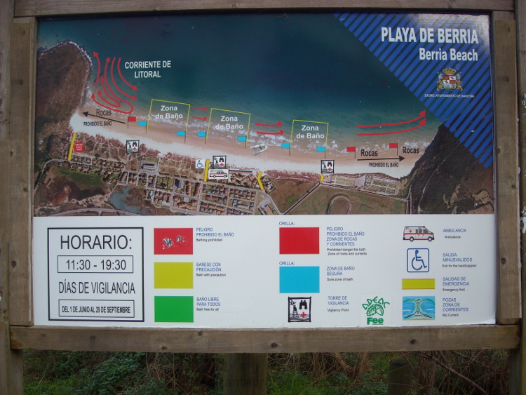
Icono Español. Icon, Spanish La Playa de Berria tiene una longitud de 2200 metros. Es una joya de costa Cántabra, ya que a su contexto natural idílico,  se le añade la naturaleza cambiante de sus aguas según la zona de la playa de la que se trate, por la proximidad a las rocas o las fuertes corrientes presentes. Por todo esto, el Ayuntamiento de Santoña ha publicado, a pie de playa en Berria, unos mapas fotográficos, trípticos con toda la información de la Playa de Berria y sus aguas. Es útil prestar atención a ese tipo de información si vamos a practicar surf o realizar otras actividades en las mejores condiciones, de forma segura. Aquí dejo una fotografía de uno de estos carteles.

Berria beach, working areas

Icono Inglés. Icon, English Berria Beach has a length of 2200 meters. It is a jewel of the Cantabrian coast, because to its natural idyllic context, is added the changing nature of their waters according to the area of the beach, the proximity to the rocks or the strong currents. Due to this, the Town Hall of Santoña has published, on the beachfront of Berria, some photographic maps and brochures with all the information about the beach of Berria, and its waters. It is useful to pay attention to that kind of information if we are going to play surf or another activities in the best conditions, safely. Here is a photograph of one of these posters.

Separador. DividerIcono Español-Inglés. Icon Spanish-English
Playa de Berria, zonas hábiles. Berria beach, working areasIcono separador. Icon divider

Icon close Sponsor

Share

Somo, El Puntal. Ruta de senderismo

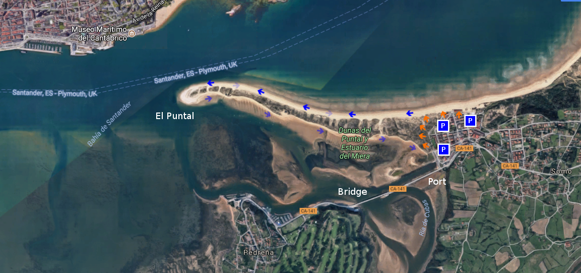
Icono Español. Icon Spanish. Somo, El Puntal, ruta Somo es una localidad costera cántabra situada en la orilla sur de la Bahía de Santander. Emplazada en la costa central de Cantabria, dispone y tiene acceso a un extenso arenal de más de 7 kilómetros de longitud. Esta zona única contiene varias playas establecidas en mar abierto que reciben el oleaje del Mar Cantábrico.

La playa situada en el extremo occidental es conocida como El Puntal, una lengua de arena con tres kilómetros de longitud. Bañada por el mar en sus dos vertientes, dispone de un recinto dunar; existente a lo ancho de su área. Su ruta de ida y vuelta requiere mesura y una condición física mínima. El camino se realiza por arena, o a través de pequeños senderos irregulares abiertos entre las dunas.

La ruta comienza en Somo. Desde cualquier localización podremos acceder a la playa y comenzar la travesía. Un punto de partida adecuado es el Embarcadero de Somo, cuenta con un amplio aparcamiento y varios accesos a las dunas. El camino empieza ofreciendo una vista panorámica de la bahía. La ciudad de Santander, al fondo, completa el mosaico. Cada paso irá acompañado por el sonido del oleaje. El color azulado y oscurecido del agua descubre una línea imaginaria que recorrer la orilla, invitando a continuar y descubrir su final. La arena húmeda que aparece en bajamar facilita la ruta que puede ser alternada sobre arena seca, acorde a nuestra condición física. A mitad de camino, sobre la silueta del banco de arena, aparece una curva interior seguida de otra exterior. En este punto, va asomando la ciudad, descubriendo su profundidad conforme avanzamos.

Al final del recorrido, un amplio espacio presenta singulares vistas de la Bahía de Santander. El atardecer lucirá un plano general enmarcado por el cielo y el entorno. El camino de regreso puede ser realizado volviendo sobre nuestros pasos o eligiendo el lados sur de El Puntal. Desde allí es posible disfrutar de otros espacios y localidades que comparten la bahía, finalizando con el Puente de Somo, la Ría de Cubas y el Embarcadero.

Separador. DividerIcono Español-Inglés. Icon Spanish-EnglishSomo, El PuntalIcono separador. Icon divider

Somo, El Puntal. Trekking route

Icono Inglés. Icon English. Somo, El Puntal, trekking route Somo is a coastal locality Cantabrian placed in the south shore of the Bay of Santander. Located on the central coast of Cantabria, it arranges and has access to an extensive sandbank of more than 7 kilometres of length. This unique zone contains several beaches established on the open sea that receive the surge of the Cantabrian Sea.

The beach placed in the western end is known as El Puntal, a language of sand with three kilometres of length. Sorrounded by the sea in its two slopes, it has a dune enclosure widthways its existing area. Its round trip route needs moderation and a minimum physical condition. The way is realized by sand, or across small irregular paths opened between the dunes.

The route begins in Somo. From any location we will be able to accede to the beach and to begin the voyage. An ideal point of is The Port of Somo, relies a wide parking and several accesses to the dunes. The way starts by offering a panoramic sight of the bay. The city of Santander, to the bottom, completes the mosaic. Every step will be accompanied by the sound of the surge. The color bluish and got dark of the water discovers an imaginary line that run cross the shore, inviting to continue and discover its end. The humid sand that appears in low tide facilitates the route that can be alternated over dry item, as allow our physical condition. To midway, on the silhouette of the sandbank, there appears an interior curve followed by exterior other one. In this point, the city is going appear, discovering its depth as we advance.

At the end of the tour, a wide space presents a singular views of the Bay of Santander. The sunset will illuminate an outlook framed by the sky and the environment. The return way can be realized over our steps or choosing the south side of El Puntal. From there it is possible to enjoy other spaces and localities that share the bay, finishing with the Bridge of Somo, the Estuary of Cubas and the Port.

Icon close Sponsor. 
Somo, El Puntal

Share

De Liencres hacia Robayera, ruta de senderismo

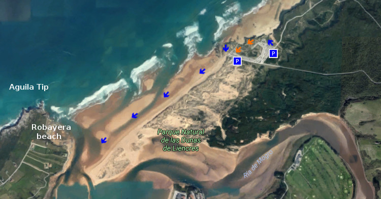
Icono Español. Icon Spanish. Liencres a Robayera, ruta La playa de Liencres, también conocida como Valdearenas, está situada en la costa central de Cantabria. Localizada al Oeste de Santander, es un extenso arenal de 2800 metros de longitud. Contando con dos amplias zonas de aparcamiento, el primero de ellos está emplazado a la entrada de la playa. El segundo parking se sitúa a la derecha del acantilado que separa el arenal grande de la otra playa de Liencres, Canallave.

Eligiendo la cima del acantilado, comenzaremos la ruta. En la cima rocosa la vegetación dunar, característica de la zona, recubre el espacio disponiendo un lecho de arena y tierra. Un pequeño sendero inicia el camino hacia la izquierda. A lo lejos, el horizonte se extiende y acota por la Punta del Águila. El cabo ubicado en la península que contiene a la playa de Robayera, marcará la dirección del paseo. Los primeros pasos recorren zigzageantes el camino que se perfila sobre el acantilado y descubren una pequeña cala. Cantos rodados y arena forman su lecho, rocas erosionadas, de caras irregulares y puntiagudas en el mar que la baña.

A 200 metros, encontramos la entrada de Valdearenas. Una rampa proporciona el acceso al arenal que comienza sobre un trazado ligeramente curvo para prolongarse hasta su extremo. La fuerza del Mar Cantábrico y los temporales dibujan cada temporada su forma, registrando este efecto sobre la superficie. Avanza la playa sobre el mar, entra éste en pequeños canales hacia la arena. El recorrido transcurre apacible flanqueado por dunas cuya altura decrece hasta igualarse con la playa a cien metros del final.

Tornanse los pasos placenteros a medida que avanzamos hacia la lengua de arena. La Punta del Águila cobija la salvaje cala. Próximo al final, donde la playa se curva de nuevo, aparecen grandes urros; cercanos a la línea de costa. Enormes formaciones rocosas, vestigio de la ancestral tierra que a modo de gigantes dan testimonio del paso del tiempo. Suceder y fluir, representación plasmada a través de la Ría de Mogro que separa el final de la ruta de la dirección originaria, Robayera.

Separador. DividerIcono Español-Inglés. Icon Spanish-Englishliencres, robayera, routeIcono separador. Icon divider

Liencres to Robayera, trekking route

Icono Inglés. Icon English. Liencres To RObayera, trekking route Liencres’s beach, also known as Valdearenas, is placed on the central coast of Cantabria. Located to the West of Santander, it is an extensive sandbank of 2800 meters of length. Possessing two wide zones of parking, the first one of them is located at the entry of the beach. The second parking places to the right of the cliff that separates the big sandbank from another beach of Liencres, Canallave.

Choosing the top of the cliff, we will begin the route. In the rocky top the dune vegetation, typical of the zone, covers the space arranging a bed of sand and land. An small path initiates the way towards the left side. In the distance, the horizon spreads and annotates by the Tip of the Aguila. The Cape located in the peninsula that contains Robayera’s beach, will mark the direction of the outing. The first steps cross zigzagging the way that is outlined on the cliff and discover an small cove. Rolled stones and sand form its bed, eroded rocks, of irregular and sharp-pointed faces in the sea that bathes it.

To 200 meters, we find Valdearenas’s entry. A ramp provides the access to the sandbank that begins on a tracing lightly curved to extend up to its end. The force of the Cantabrian Sea and the temporaries draw every season its form, registering this effect on the surface. It advances the beach on the sea, this one enters through small channels towards the sand. The tour passes pleasantly flanked by dunes which height decreases up to being equal with the beach to hundred meters of the end.

Turn into pleasant the steps as we advance towards the language of sand. The Tip of the Águila shelters the wild cove. Next to the wing, where the beach bows again, big boulders appear; near to the coastline. Enormous rocky formations, vestige of the ancient land that like giants give testimony of the passage of time. To happen and flow, representation expressed across the Estuary of Mogro that separates the end of the route of the original direction, Robayera.

Icon close Sponsor

Share

Playa de La Salvé, ruta

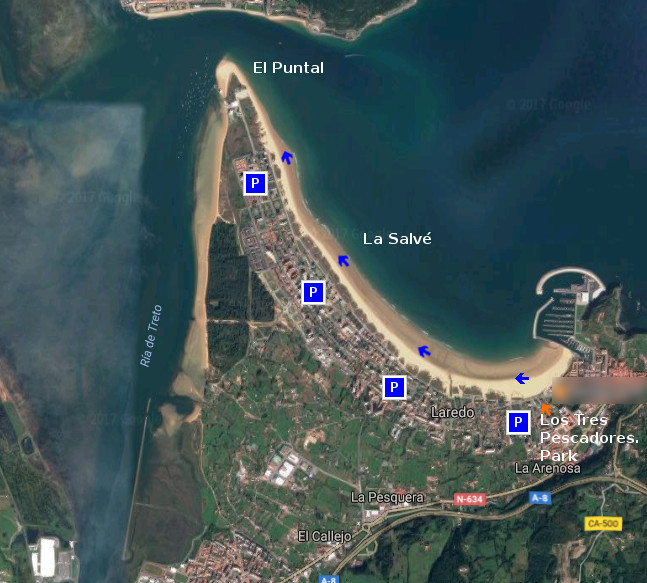
Icono Español. Icon Spanish. La Salve, ruta La playa de La Salvé, situada en Laredo, es la playa más larga de Cantabria. Su longitud de 4250 metros y anchura media de 120 metros habilitan un extenso área cuya forma curvada acota parte de la localidad y su unión con el Mar Cantábrico. El recorrido es acompañado por un Paseo Marítimo que se prolonga hasta el Puntal, lengua de arena que delimita la entrada a la Bahía de Santoña en uno de sus extremos.

Empezaremos la ruta en el Parque de los Tres Pescadores, zona ajardinada próxima al puerto deportivo y localizado en el extremo Este del recorrido. Desde allí, podemos elegir entrar al arenal o caminar por el Paseo Marítimo. El principio del recorrido posee el tramo más curvado, por lo que la aparición de edificios y dunas irán descubriendo los encantos sencillos de un simple paseo. A medida que avancemos, los pasos sobre la arena acumularán un tonificado desgaste. Es aconsejable caminar cerca de la orilla, donde la arena que abandonó el agua por las mareas permanece más dura y facilita el camino. Tras el comienzo, una recta alargada aparece. Acompañados por el sonido aleatorio y orquestral del océano conseguiremos dejar atrás el bullicio urbano. La brisa, presente en la zona, endulzará el viaje y proyectará la imaginación que el entorno disparó. Cualquier punto del recorrido es adecuado para terminar nuestro paseo, acorde a la condición física de cada uno y el tiempo disponible.

El final del trayecto hará aparecer El Puntal de Laredo. Península arenosa y dunar que sirve de bisagra a la entrada de la Bahía de Santoña. Este punto único, emplazamiento privilegiado de su entorno, proporciona una visión panorámica de un espacio singular creado por la naturaleza a través del tiempo. En ese momento es aconsejable buscar un pequeño espacio a modo de silla, reposar y degustar el final del trayecto.

Separador. DividerIcono Español-Inglés. Icon Spanish-Englishla Salvé , Trekking RouteIcono separador. Icon divider

Beach La Salvé, route

Icono Inglés. Icon English. La Salve, route The beach of La Salvé, placed in Laredo, it is the longest beach of Cantabria. Its length of 4250 meters and average width of 120 meters enable an extensively area which curled form annotates part of the locality and its union with the Cantabrian Sea. The tour is accompanied by a Maritime Promenade that prolongs up to El Puntal, language of sand that delimits the entry to Bay of Santoña in one of its ends.

We will begin the route in Los Tres Pescadores Park , landscaped zone next the yachting port and located in the East extreme of the tour. From there, we can choose enter to the sandbank or walk along the seafront. The beginning of the journey possesses the most curled section, so the appearance of buildings and dunes will discover the easier captivations of a simple walk. As we advance, the steps on the sand will accumulate a strengthened wear. It is advisable to go near the shore, where the sand that left behind the water by the tides remains harder and facilitates the way. After the beginning, an elongated straight line appears. Accompanied by the random and orquestral sound of the ocean we will manage to leave behind the urban hustle. The breeze, present in the zone, will sweeten the trip and will project the imagination that the environment shot. Any point of the tour is adapted to finish our tour, chord to the physical condition of each one and the available time.

The end of the distance will make appear El Puntal of Laredo. Sandy and dune peninsula, that runs as a hinge, at the entry of Bay of Santoña. Thisunique point, privileged emplacement of its environment, provides a panoramic vision of a singular space created by the nature across the time. In this moment it is advisable to look for an small space as a chair, to rest and to taste the end of the distance.

Icon close Sponsor

Share

Sopico, lugar

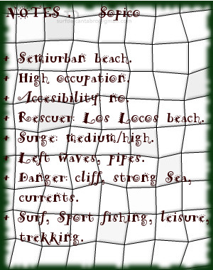
Icono Español. Icon Spanish. Sopico, lugar Sopico, emplazamiento localizado en la localidad de Suances, es un pequeño cabo que separa las playas de Los Locos y La Tablía. La marea baja descubre las rocas que se apilan en la base del acantilado, quedando la arena cubierta por el agua.

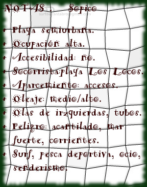
Al acceso a este punto de olas se realiza por las playas colindantes. Destacan las fuertes corrientes y el oleaje, proporcionando olas prácticamente durante todo el año. La ola característica de Sopico abre a izquierdas, manteniendo la misma calidad sin importar las mareas. Aparecen olas cortas y maniobrables, alternadas con olas más profundas y de recorrido medio/largo. Debido a sus características tiene una ocupación alta, siendo exigido respetar las normas y turnos.

La cima de Sopico cuenta con un mirador panorámico que abre al caminante la amplitud de la Ensenada de Cabrera. La La contemplación del entorno recorre desde Suances a la derecha hasta Punta Ballota cerrando extremo izquierdo, entreteniendo la mirada sobre el horizonte; que mostrará la naturaleza del Mar Cantábrico.

Cabecera Cities Place Beaches . Sopico, lugar
Sopico, notas

Sopico, place

Icono Inglés. Icon English. Sopico, lugar Sopico, emplacement located in the locality of Suances, is a small end that separates the beaches of Los Locos and La Tablía. The low tide discovers the rocks that are piled up in the base of the cliff, staying the sand covered by the water.

The access to that point of waves it is realized by the adjacent beaches. The strong currents and the surge stand out, providing waves practically all the year round. The wave typical Sopico’s opens to left sides, supporting the same quality without importing the tides. There appear short and manoeuvrable waves alternated with deeper waves and of meium tour. Due to its characteristics it has a high occupation, being demanded the respect to the procedure and shifts.

The top of Sopico has a panoramic viewing-point that opens the wayfarer the extent of Cabrera’s Inlet. The contemplation of the environment crosses from Suances to the right up to Ballota Tip closing the left wing, entertaining the look on the horizon; that will show the nature of the Cantabrian Sea.

Cabecera Cities Place Beaches. Sopico, place
Sopico, notes

Share

EL Pedrero, playa

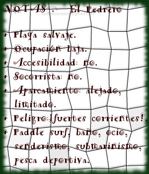
Icono Español. Icon Spanish. El Pedrero, playa La playa El Pedrero está situada en la localidad de Pechón, perteneciente al municipio de Val de San Vicente. Emplazada en la desembocadura de la Ría de Tina Mayor, es la playa más occidental de Cantabria.

Este pequeño arenal, compuesto por arena blanca y grava, tiene una longitud de 200 metros y anchura media de 10 metros. Sus dimensiones, cambiantes por efecto de las mareas, acotan una plataforma desde donde contemplar la excepcional belleza del lugar. El final del estuario, desembocadura del Río Deva, se reúne con el Mar Cantábrico; que expresa su naturaleza y fuerza en toda la línea de costa del municipio cántabro.

El entorno de media montaña en el que existe la playa dispone un idílico ambiente. Árboles, rocas y mar, armonizados por el sonido del agua en su movimiento.

Cabecera Cities Place Beaches . El Pedrero, playa
El Pedrero, notas

El Pedrero, beach

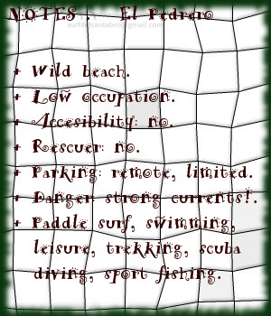
Icono Inglés. Icon English. El Pedrero, beach The beach El Pedrero is placed in the locality of Pechón, belonging to the municipality of Val de San Vicente. Located in the Tidal River of Tina Mayor, it is the most western beach of Cantabria.

This small sandbank composed by white sand and loose stones, has a length of 200 meters and an average width of 10 meters. Its dimensions, changeable for effect of the tides, draw a platform from where contemplating the exceptional local beauty. The end of the estuary, river mouth of the Deva River, meets the Cantabrian Sea; that expresses its nature and force in the whole line of coast of the Cantabrian municipality.

The environment with medium-sized mountains in which the beach exists arranges an idyllic natural surroundings. Trees, rocks and sea harmonized by the sound of the water in its movement.

Cabecera Cities Place Beaches. El Pedrero, beach
El Pedrero, notes

Share

EL Sable, playa

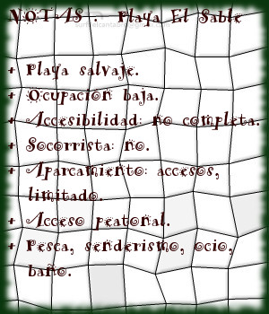
Icono Español. Icon Spanish. El Sable, playa El Sable es una playa situada en la localidad de Prellezo, perteneciente al municipio de Val de San Vicente. Emplazada en el interior de la Ría de Tina Menor, su fisonomía está determinada por el trasiego de las mareas y la configuración del estuario.

El Sable, playa de 350 metros de longitud y apenas 10 metros de anchura media, es un pequeño y particular arenal. Localizada entre la desembocadura del Río Nansa y el cierre de la Ría de Tina Menor, disponen de aguas tranquilas y protegidas de mar abierto. Su entorno natural y salvaje se encuentra poblado de bosque atravesado por senderos. El lado derecho de la ría que ocupa la playa es transitable en marea baja hasta su final y al encuentro con el mar. La tranquilidad natural que reina en la zona convierten la estancia en un reconstituyente descanso.

El otoño trae consigo las grandes mareas, removiendo el fondo de arena y arcilla. Tiñe la zona de color beige y deposita nuevos sedimentos que alimentan la diversidad biológica presente. La primavera hace regresar las aves y completa un sistema que puede ser disfrutado desde la playa de El Sable.

Cabecera Cities Place Beaches . El Sable, playa
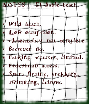
El Sable, notas

El Sable, beach

Icono Inglés. Icon English. El Sable, beach El Sable is a beach placed in the locality of Prellezo, belonging to the municipality of Val de San Vicente. Located inside the Estuary of Tina Menor, its physiognomy is determined by the decanting of the tides and the configuration of the tidal river.

El Sable, beach of 350 meters of length and just 10 meters of average width, is an small and particular sandbank. Located between the river mouth of the Nansa River and the closing of Tina Menor, it has calm waters and protected from open sea. Its natural and wild environment is populated of forest crossed by paths. The right side of sea inlet that occupies the beach, it is pasable in low tide until its end and to the meeting with the sea. The natural tranquility that reigns in the zone, turns the stay into a restorative rest.

The autumn brings with it the big tides, removing the bottom of sand and clay. It dyes the zone of beige color and new sediments are despositated that feed the present biological diversity. The spring makes return the birds and completes a system that can be enjoyed from the beach of El Sable.

Cabecera Cities Place Beaches. El Sable, beach
El Sable, notes

Share