El arco de las olas
![]() El arenal en el que está incluida la Playa de Somo tiene una extensión de 7 km. Desde el punto medio de este extenso arenal, situados en tierra firme y volviendo la mirada hacia la izquierda se encuentra la Playa del Puntal. A la derecha la Playa de Loredo. Prácticamente en todo el recorrido se puede practicar surf. Además hay varias zonas donde la frecuencia y la calidad de las olas componen un área a modo de circuito. Existen varios de estos puntos y cada uno tiene olas diferentes.
El arenal en el que está incluida la Playa de Somo tiene una extensión de 7 km. Desde el punto medio de este extenso arenal, situados en tierra firme y volviendo la mirada hacia la izquierda se encuentra la Playa del Puntal. A la derecha la Playa de Loredo. Prácticamente en todo el recorrido se puede practicar surf. Además hay varias zonas donde la frecuencia y la calidad de las olas componen un área a modo de circuito. Existen varios de estos puntos y cada uno tiene olas diferentes.
Entre la entrada principal de la Playa de Somo y la «Curva» de Loredo, la arena y el mar se dibujan en una recta de 500 metros; con un parque dunar a su espalda. Se lo conoce como Pinar de Arna. Con un pequeño parking a su entrada y separado del pinar por una valla de madera. Es un lugar ideal para realizar senderismo e ir de comida a la playa. Al fondo unas impresionantes vistas componen un cuadro único compuesto por la ciudad de Santander a un lado, la Isla de Mouro en la parte central vigilando la bahía, y la Isla de Santa Marina cerrando la composición en el otro lado. Todo ello unido por el mar. El mar que baña la tierra, las rocas y las islas. Uniendo todo el espacio y desapareciendo con la línea del horizonte.
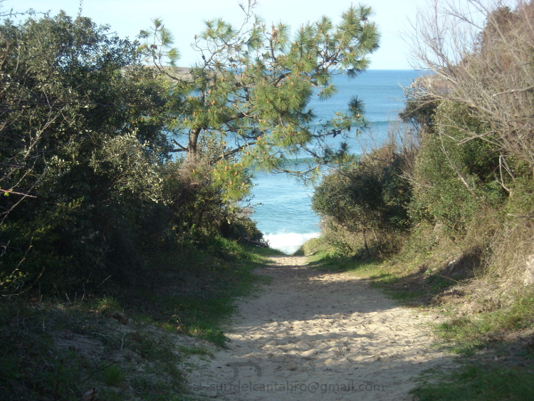
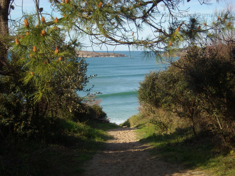
En la entrada del parque, a la derecha de la vaya, existe un camino que conduce directamente a la playa. Delimitado por rocas dispuestas en línea recta que indican la dirección adecuada. El trayecto se hunde irregularmente y transcurre en un estado natural y salvaje. Próximo a su final, un árbol inclinado sobre el recorrido dibuja un arco cerrado por la vegetación y el entorno. Dentro de él una ventana se abre. Las olas se ven llegar y el sonido orquesta el mayor de los estímulos para practicar surf y disfrutar de la naturaleza. Sólo un desnivel de 20 metros separa el final del pinar, de la playa. Bajando por un tobogán de arena que exige precaución y buena condición física se llega a donde uno antes imaginaba.
The arc of the waves
![]() In The arenal which is placed the Somo Beach has an extension of 7 km. From the mid-point of this extensive stretch of sand, on land and looking to the left is El Puntal Beach. To the right is Loredo Beach. In virtually all parts of the route can be surfing. In addition there are several areas where the frequency and quality of the waves make up an area by way of circuit. There are several of these points and each one has different waves.
In The arenal which is placed the Somo Beach has an extension of 7 km. From the mid-point of this extensive stretch of sand, on land and looking to the left is El Puntal Beach. To the right is Loredo Beach. In virtually all parts of the route can be surfing. In addition there are several areas where the frequency and quality of the waves make up an area by way of circuit. There are several of these points and each one has different waves.
Between the main entrance of the Playa de Somo and the «Curve» of Loredo, sand and sea are drawn in a straight line of 500 meters, with a dune park to its back. It is known as Pinar Arna. With a small parking lot to its entry and separate from the pine forest by a wooden fence. It is an ideal place for hiking and go for lunch to the beach. At the end, a breathtaking views make up a picture consisting of the city of Santander to one side, Mouro Island in the central part watching the bay, and the Santa Marina Island closes the composition on the other side. All of this kingdom is met by the sea. The sea that bathes the land, the rocks and islands. Uniting all the space and disappearing with the horizon line.
At the entrance to the park, to the right of the go, there is a path that leads directly to the beach. Bounded by rocks arranged in a straight line to indicate the right direction. The journey is irregularly and takes place in a natural and wild state. Next to its end, a tree leaning over the tour draws a bow closed by the vegetation and the environment. Within it a window opens. The waves arrive and the sound produce a powerfull stimuli for surfing and enjoy the nature. Only a drop of 20 meters separates the end of the pine forest to the beach. You can go down through a waterslide of sand that requires caution and good physical condition. Then you are going to be in a place that you have imagined before.
![]()
![]()
![]()
![]()