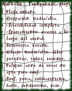
Trengandín, playa
![]() La playa de Trengandín está ubicada en el municipio de Noja, en la costa oriental de Cantabria. Es uno de los arenales más extensos de la costa cántabra con una longitud de 6000 metros y una anchura media aproximada de 100 metros. Debido a sus dimensiones, contiene varias zonas diferenciadas.
La playa de Trengandín está ubicada en el municipio de Noja, en la costa oriental de Cantabria. Es uno de los arenales más extensos de la costa cántabra con una longitud de 6000 metros y una anchura media aproximada de 100 metros. Debido a sus dimensiones, contiene varias zonas diferenciadas.
La primera parte de la playa, situada de zona urbana de la villa, tiene forma curva e irregular. Sus aguas repletas de afiladas rocas forman un espectacular paisaje en marea baja. Es una área adecuada para el ocio, baño, submarinismo, no siendo apta para practicar surf, pues las formaciones rocosas inundan la zona y sobresalen por encima del agua. El siguiente tramo que comienza en el Barrio de Helgueras y corre paralelo a los Montes de Mijedo, recibe el nombre de playa de Helgueras. Ocupada hasta la mitad del recorrido por rocas que van desapareciendo hasta encontrar la otra mitad libre y limpia de obstáculos para la práctica del surf. Su parte final, próxima al Monte EL Brusco, es conocida como El Brusco.
El Mar Cantábrico ingresa en la Ensenada de Noja superando la Punta de la Mesa, filtrando el oleaje, que se proyecta hacia la línea de costa. Recibe Helgueras olas que abren a izquierdas, con tamaño medio-alto, y alcanzan largo recorrido. El otoño, que registra mareas grandes, propicia olas de mayor tamaño. Desplazando las masas de agua sobre la ensenada, con suave pendiente y altura superior a los tres metros, aparecen tubos y navegaciones prolongadas. Existen otros picos de olas en la zona que abren a ambos lados y favorecen las maniobras.

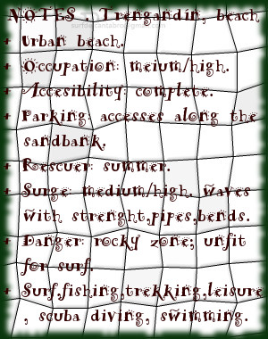
Trengandín, beach
![]() The beach of Trengandín is located in the municipality of Noja, on the oriental coast of Cantabria. It is one of the most extensive sandbanks of the Cantabrian coast with a length of 6000 meters and an average approximate width of 100 meters. Due to its dimensions, it contains several differentiated zones.
The beach of Trengandín is located in the municipality of Noja, on the oriental coast of Cantabria. It is one of the most extensive sandbanks of the Cantabrian coast with a length of 6000 meters and an average approximate width of 100 meters. Due to its dimensions, it contains several differentiated zones.
The first part of the beach, placed on urban zone of the villa, has a curved and irregular form. Its waters replete with sharp rocks form an spectacular landscape in low tide. It is an area adapted for the leisure, swimming, scuba diving, not being suitable to practise surf, since the rocky formations flood the zone and stand out over the water. The following section that begins in the Neighborhood of Helgueras and runs parallel to the Mounts of Mijedo, receives the Helgueras’s beach name. Occupied up to the half of the tour by rocks that disappear up to finding the second free and clean area of obstacles for the practice of the surf. Its final part, next the Mount El Brusco, is known as El Brusco.
The Cantabrian Sea enters in the Inlet of Noja overcoming the Mesa Tip, filtering the surge, which is projected towards the line of coast. Helgueras receives waves that open to left side, with medium-high size, and reach crossed length. The autumn, which registers big tides, propitiates waves of major size. The movement of the water masses in the inlet, with soft earring and height superior to three meters, brings up pipes and long navigations. Other beaks of waves exist in the zone that open for both sides and propitiates the maneuvers.