Noja, ciudad

Icono Español. Icon Spanish. Noja, city Noja, singular municipio de la costa oriental de Cantabria, es una villa cuya organización se articula en barrios. Delimitado en el oeste por la Playa de los Barcos, en el este está acotada por el Monte EL Brusco, que da nombre a la playa que se sitúa en sus accesos.

Su costa rocosa e irregular supera los 15 kilómetros de longitud y cuenta con varios arenales de fina y blanca arena. Las playas de los Barcos, Ris, Trengandín y el Brusco ocupan el 70% de la línea de costa. Variedad ofrece al visitante un amplio abanico de opciones donde practicar el baño y disfrutar del descanso. El surf, la pesca, el submarinismo y demás deportes acuáticos pueden ser disfrutados en sus arenales. La orografía de la cara Este de la villa contiene la Ensenada de Noja. Las talladas rocas que pueblan la bahía asoman sus afiladas cimas sobre las aguas del Mar Cantábrico y proporcionan un espectáculo de belleza onírica con la marea baja.

Las Marismas De Victoria y Joyel, rodean el municipio y componen, junto con las Marismas de Santoña, el mayor humedal de la cornisa cantábrica. Ambos estuarios disponen de observatorios para aves y senderos que los rodean y/o atraviesan, ofreciendo distintas perspectivas del parque natural que forman. Estos tesoros que forman parte del patrimonio de Noja pueden anticipar la inmensidad de la zona que será descubierta con cada paso, en cada rincón.

Noja, city

Icono Inglés. Icon English. Noja, city Noja, singular municipality of the oriental coast of Cantabria, is a villa which organization is articulated in neighborhoods. Delimited in the west for the Beach of Los Barcos, in the East there is annotated by the Mount El Brusco, which gives name to the beach that places in its accesses.

Its rocky and irregular coast overcomes 15 kilometres of length and possesses several sandbanks of thin and white sand. The beaches of Los Barcos, Ris, Trengandín and El Brusco occupy 70 % of the line of coast. Variety that offers a widely range of options to the visitor where to practise the swimming and enjoy the relaxation. The Surf, the fishing, the scuba diving and other aquatic sports can be enjoyed in its sandbanks. The orography of the west face of the villa contains the Inlet of Noja. The chiseled rocks that populate the bay put its sharp tops over the waters of the Cantabrian Sea and provide a spectacle of oneiric beauty in the low tide.

The Marshes of Victoria and Joyel, surround the municipality and compose, with Santoña’s Marshes, the major wetland of the Cantabrian cornice. Both estuaries have observatories for birds and paths that surround and / or cross them, offering different perspectives of the nature reserve that form. These exchequers that form a part of Noja’s heritage can anticipate the immensity of the zone that will be discovered by every step, in every corner.

Icon text divider

Noja, city. Route

Icono español-inglés. Icon Spanish-English. Noja, city Noja, ciudad

Noja, City

icon close cities

Share

Trengandín, playa

Icono Español. Icon Spanish. Trengandín, playa La playa de Trengandín está ubicada en el municipio de Noja, en la costa oriental de Cantabria. Es uno de los arenales más extensos de la costa cántabra con una longitud de 6000 metros y una anchura media aproximada de 100 metros. Debido a sus dimensiones, contiene varias zonas diferenciadas.

La primera parte de la playa, situada de zona urbana de la villa, tiene forma curva e irregular. Sus aguas repletas de afiladas rocas forman un espectacular paisaje en marea baja. Es una área adecuada para el ocio, baño, submarinismo, no siendo apta para practicar surf, pues las formaciones rocosas inundan la zona y sobresalen por encima del agua. El siguiente tramo que comienza en el Barrio de Helgueras y corre paralelo a los Montes de Mijedo, recibe el nombre de playa de Helgueras. Ocupada hasta la mitad del recorrido por rocas que van desapareciendo hasta encontrar la otra mitad libre y limpia de obstáculos para la práctica del surf. Su parte final, próxima al Monte EL Brusco, es conocida como El Brusco.

El Mar Cantábrico ingresa en la Ensenada de Noja superando la Punta de la Mesa, filtrando el oleaje, que se proyecta hacia la línea de costa. Recibe Helgueras olas que abren a izquierdas, con tamaño medio-alto, y alcanzan largo recorrido. El otoño, que registra mareas grandes, propicia olas de mayor tamaño. Desplazando las masas de agua sobre la ensenada, con suave pendiente y altura superior a los tres metros, aparecen tubos y navegaciones prolongadas. Existen otros picos de olas en la zona que abren a ambos lados y favorecen las maniobras.

Cabecera Cities Place Beaches. Trengandín, playa
Trengandin, playa. Notas

Trengandín, beach

Icono Inglés. Icon English. Trengandín, beach The beach of Trengandín is located in the municipality of Noja, on the oriental coast of Cantabria. It is one of the most extensive sandbanks of the Cantabrian coast with a length of 6000 meters and an average approximate width of 100 meters. Due to its dimensions, it contains several differentiated zones.

The first part of the beach, placed on urban zone of the villa, has a curved and irregular form. Its waters replete with sharp rocks form an spectacular landscape in low tide. It is an area adapted for the leisure, swimming, scuba diving, not being suitable to practise surf, since the rocky formations flood the zone and stand out over the water. The following section that begins in the Neighborhood of Helgueras and runs parallel to the Mounts of Mijedo, receives the Helgueras’s beach name. Occupied up to the half of the tour by rocks that disappear up to finding the second free and clean area of obstacles for the practice of the surf. Its final part, next the Mount El Brusco, is known as El Brusco.

The Cantabrian Sea enters in the Inlet of Noja overcoming the Mesa Tip, filtering the surge, which is projected towards the line of coast. Helgueras receives waves that open to left side, with medium-high size, and reach crossed length. The autumn, which registers big tides, propitiates waves of major size. The movement of the water masses in the inlet, with soft earring and height superior to three meters, brings up pipes and long navigations. Other beaks of waves exist in the zone that open for both sides and propitiates the maneuvers.

Cabecera Cities Place Beaches. Trengandín, beach
Trengandin, beach. Notes

Share

Noja, Playa de Ris .

Icono Español. Icon Spanish. Noja, Ris beach La playa de Ris está ubicada en el municipio de Noja, perteneciente a la comarca de Trasmiera; en la costa occidental de Cantabria. Su longitud de 2200 metros y anchura media de 100 metros, junto con su emplazamiento urbano, hacen de ella una playa con un alto grado de ocupación.

Este gran arenal tiene dos partes diferenciadas. Una de ellas, próxima a la Ría de Quejo, es una zona retirada, tranquila, situada en el límite de Las Marismas de Joyel (una de las tres partes que componen el Parque Natural de las Marismas de Santoña, Victoria y Joyel) y por ello se la conoce como Playa de Joyel. Gobernada por el ritmo de las mareas, que ocultan el 60% de la superficie de la playa con la pleamar. La otra zona, emplazada frente a Noja y delimitada en sus extremos por islotes rocosos, es la parte urbana de la playa de Ris. Descubre la bajamar el fondo arenoso y parcialmente cubierto por rocas, la forma curvada de la playa y el agua retrocediendo desde la orilla hacia el Mar Cantábrico; creando pequeños remolinos en los laterales por los efectos de las corrientes.

La Playa de Ris es, por sus características, recomendable para el ocio, la pesca y el baño. Ideal para la práctica de paddle sup, con la mar tranquila. Surfear en esta playa produce sesiones entretenidas para todos los niveles cuando las condiciones son aceptables. Allí, La Mar fuerte es sólo apta para surfers experimentados que conozcan bien la zona y para caminantes que quieran disfrutar del espectáculo de un temporal en esta parte de la costa cántabra.

Cabecera Cities Place Beaches. Noja, Ris beach
Ris, Notas

Noja, Ris beach

Icono Inglés. Icon English. Noja, Ris beach The beach of Ris is located in the municipality of Noja, belonging to the region of Trasmiera; on the western coast of Cantabria. Its length of 2200 meters and average width of 100 meters, added up to its urban emplacement, do of it a beach with a high degree of occupation.

This great sandbank has two differentiated parts. One of them, next to the Stuary of Quejo , it is a calm and remote zone, placed in the limit of The Marshes Joyel (one of three parts that compose the Nature reserve of Santoña’s Marshes, Victoria and Joyel) and due to this is known as Beach of Joyel. Governed by the pace of the tides, which conceals the 60% of the surface of the beach with the high tide. The other zone located opposite to Noja and delimited in its ends by rocky islands, is the urban part of Ris’s beach. The low tide discovers the sandy bottom and partially covered by rocks, the curved form of the beach and the water moving back from the shore towards the Cantabrian Sea; creating small whirlpools in the wings because of the effects of the currents.

The Beach of Ris is advisable for the leisure, the fishing and the swimming. Ideal for the practice of paddle sup, with the calm sea. To play surf in this beach produces enjoyable sessions for all the levels when the conditions are acceptable. There, The strong Sea is only suitable for experienced surfers that know well the zone and for wayfarers who want to enjoy the spectacle of the storm in this part of the Cantabrian coast.

Cabecera Cities Place Beaches. Noja, Ris beach
Ris beach, notes

Share

El Brusco , lugar

Icono Español. Icon Spanish. El Brusco place EL Brusco es un monte emplazado en el municipio de Noja,en la costa oriental de Cantabria. Situado al final de la playa de Trengandín, tiene una altura de 99 metros y una superficie aproximada de 15 hectáreas. Su arcaica estructura se muestra y esconde al compás de las mareas. Aparecen los cimientos con la bajamar. Intuidos sobre un mosaico compuesto por miles de rocas. Afiladas, troceadas, por el mar tocadas.

Este pequeño monte constituye un emplazamiento singular. Incluido en la formación montañosa de los Montes de Mijedo, es la única zona del macizo que sobresale en la línea de costa y cuya base se asienta en el mar. La ubicación y el medio que lo rodean, han moldeado su perímetro y dibujado su forma, con el paso del tiempo; convirtiendo al monte en frontera natural entre las playas de Trengandín y Berria y los municipios de Noja y Santoña.

A los pies del Brusco comienza una senda que conduce a lo alto del monte, para descender de nuevo hacia el otro lado hasta encontrar la playa de Berria. Transcurre el sendero inundado de vegetación. Robles y hayas predominan en la zona, acompañados de sotobosque. Este paso natural, convertido en senda, tiene una anchura de apenas medio metro. Tras los primeros pasos, las distancias a los puntos contiguos se agrandan, haciendo recordar la civilización como un ruido distante. Acto seguido aparecerá una natural y sencilla melodía, siempre nueva y no obstante; familiar. La brisa marina recorre todo la zona, moviendo la vegetación a su libre albedrío. Desde la cima podremos contemplar Noja y sus extensas playas a la izquierda, pasando por Berria a la derecha, El monte el Buciero y Santoña; después y entre sus marismas a modo de vivo paisaje.

Los días con buenas condiciones, las olas alcanzan los dos metros de altura. Lejos del monte, donde las corrientes son fuertes y forman remolinos, aparecen varios tipos de ola. Abriendo a ambos lados, su recorrido; a través de una tersa pared de agua, es casi constante y prolongado. Favorece las maniobras y salidas limpias .

comic, mountain
El Brusco, notas

El Brusco, place

Icono Inglés. Icon English. El Brusco place El Brusco is a mount located in the municipality of Noja, in the oriental coast of Cantabria. Placed at the end of Trengandín’s beach, it has a height of 99 meters and an approximate surface of 15 hectares. Its archaic structure appears and hides to the compass of the tides. The foundations appear with the low tide. Intuitively on a mosaic composed by thousands of rocks. Sharpened, cut into pieces, as the sea touched them , have touched and will be touched.

This small mount constitutes a singular place. Included in the mountainous formation of Mijedo’s Mounts, it is the only zone of the mountain massif that stands out in the line of coast and has its base in the sea. The location and the environment that surround it, have molded its perimeter and drawn its form with the passage of time; turning to the mountain in a natural border between the beaches of Trengandín and Berria and the municipalities of Noja and Santoña.

At the foot of El Brusco begins a path that comes up to the top, to descend again towards another side up to finding Berria’s beach. The path is flooded with vegetation. Oaks and beeches prevail in the zone, accompanied of undergrowth. This passageway turned into path, has a width of scarcely half a meter. After the first steps, the distances to the contiguous points are enlarged, making remember the civilization as a distant noise. Forthwith a natural and simple melody will appear, always newly and nevertheless; familiar. The marine breeze crosses the zone, moving the vegetation to its free will. From the top we will be able to contemplate Noja and its extensive beaches to the left, shifting for Berria to the right, The mount El Buciero and Santoña; behind and between its marshes like an alive landscape.

The days with good conditions, the waves reach two meters of height. Far from the mount, where the currents are strong and form whirlpools, several types of wave appear. Opening to both sides, its tour; across a smooth wall of water, it is almost constant and long. It favors the maneuvers and clear exits.

comic, mountain
El Brusco, notes

Share

Playa de Trengandín, Localización

Icono Español. Icon Spanish La Playa de Trengandín está situada en la Villa de Noja, en la costa oriental de Cantabria. Tiene una extensión superior a los seis kilómetros. En su parte central, su fondo arenoso se mezcla con abundantes rocas puntiagudas y afiladas, que apenas cubre la pleamar. En esta zona se puede practicar el baño, la pesca y el submarinismo, siendo peligrosa la práctica del surf. Se puede llegar a esta playa desde Oviedo, Palencia, Santander o Bilbao, como ciudades adyacentes. Todos los trayectos finalizan por la carretera nacional CA-147.

Beach of Trengandín, localization

Icono Inglés. Icon English Beach of Trengandín is placed in the Villa of Noja, on the oriental coast of Cantabria. It has an lenght over six kilometres. In its central part, its sandy bottom is mixed by abundant sharp-pointed and sharp rocks which the high tide scarcely covers. In this zone it is possible to practise the bath, the fishing and the scuba diving, being dangerous the practice of the surf. It is possible to come to this beach from Oviedo, Palencia, Santander or Bilbao, as adjacent cities. All the routes finish for the national road CA-147.

Icono Español-Inglés. Icon Spanish-English Localización/Localization

Oviedo,Playa de Trengandín: localizationPalencia, Playa de Trengandín: localizationBilbao, Playa de Tregandín: localizationSantander, Playa de Trengandín: localization

Icon close Sponsor

Share

Playa de los Barcos, acceso

Icono Español. Icon Spanish Se accede a la Playa de los Barcos por la carretera nacional CA-147, a través de la Villa de Noja y dejando atrás la Playa de Ris. La playa tiene varios puntos de accesos a lo largo de la carretera que da entrada al arenal. En el final de la Calle la Ría, seguída del Paseo Marítimo; encontraremos zonas habilitadas a modo de aparcamiento.

Playa de los Barcos, access

Icono Inglés. Icon English You can access to Playa de los Barcos through the national highway CA-147, across Villa of Noja and leaving behind Beach of Ris. The beach has several points of accesses along the road that gives entry to the sand. In the end of the Street La Ría, which is next to the Promenade; we will find zones enabled like parking.

Icono Español-Inglés. Icon Spanish-English Acceso/Access

Playa de los Barcos: access

Icon close Sponsor

Share

Playa los Barcos, Localización

Icono Español. Icon Spanish. Playa de los Barcos La Playa de los Barcos se encuentra en la Vila de Noja, en la costa oriental de Cantabria. Está ubicada entre la localidad de Isla y la Playa de Ris. Se puede llegar a esta playa desde Oviedo, Palencia, Santander o Bilbao, cómo ciudades adyacentes. Todos los trayectos finalizan por las carreteras nacionales N-634 y CA-147.

Playa Los Barcos, localization

Icono Inglés. Icon English. Los Barcos beach Beach Los Barcos is located in the Villa of Noja, on the oriental coast of Cantabria. This beach is placed between the locality Isla and the Beach of Ris. It is possible to come to this beach from Oviedo, Palencia, Santander or Bilbao, as adjacent cities. All the routes finish for the national roads N-634 and CA-147.

Icono Español-Inglés. Icon Spanish-English.Playa  Los Barcos Localización/Localization

Oviedo, Playa de Los Barcos: LocalizationPalencia, Playa de Los Barcos: LocalizationBilbao, Playa de los Barcos: LocalizationSantander, Playa de Los Barcos: localization

Icon close Sponsor

Share

Playa de Ris, acceso/access

Icono Español. Icon Spanish Se llega a la playa por la carretera nacional CA-147, atravesando la Villa de Noja. La Playa de Ris tiene múltiples accesos en sus más de 700 metros de longitud. Toda la extensión de la playa va acompañada del Paseo Marítimo, desde el cual se accede directamente a la arena. Cuenta con numerosas zonas de aparcamiento.

Icono Inglés. Icon English You can arrive to the beach for the national road CA-147, through The Villa of Noja. The Beach of Ris has multiple accesses in its more than 700 meters of length. The whole extension of the beach is parallel to the Promenade, from which you may access directly to the sand. It has numerous zones of parking.

Icono Español-Inglés. Icon Spanish-English Acceso/Access

Beach of Ris: access

Icon close Sponsor

Share

Playa de Ris, Localización

Icono Español. Icon Spanish. Playa de Ris La Playa de Ris está lozalizada en la Villa de Noja, en la costa oriental de Cantabria. Se puede llegar a esta playa desde Oviedo, Palencia, Santander o Bilbao, como ciudades adyacentes. Todos los trayectos finalizan por las carreteras nacionales N-634 y CA-147.

Beach of Ris, localization

Icono Inglés. Icon English. Beach of Ris Beach of Ris is located in the Villa of Noja, on the oriental coast of Cantabria. It is possible to come to this beach from Oviedo, Palencia, Santander or Bilbao, as adjacent cities. All the routes finish for the national roads N-634 and CA-147.

Icono Español-Inglés. Icon Spanish-English.  Playa de Ris, beach Localización/Localization

Oviedo, Ris: LocalizationPalencia, Ris: LocalizationBilbao, Ris: LocalizationSantander, Ris: localization

Icon close Sponsor

Share

El Brusco, un espectáculo inesperado

Icono Español. Icon Spanish En estos días finales del invierno y transcurridas ya dos semanas de tiempo soleado, el recuerdo de los temporales que azotaron la cornisa cantábrica parece lejano.

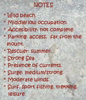
Los datos meteorológicos han revelado la inusual frecuencia de temporales y ciclogenesis explosivas que se han ido sucediendo desde diciembre hasta febrero. La cantidad de agua registrada en este período duplica y casi triplica la misma cantidad recibida en doce meses en años anteriores. Las boyas oceánicas captaron con inusitada frecuencia olas de más de 10 metros y de manera no tan excepcional olas que han superado los 20 metros. En estas condiciones la práctica del surf sólo ha sido apta para profesionales y expertos.

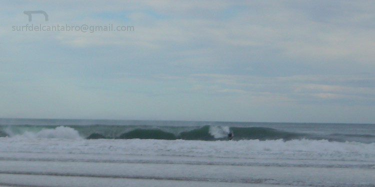
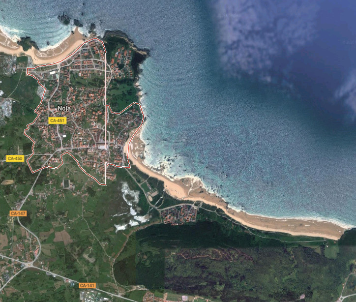
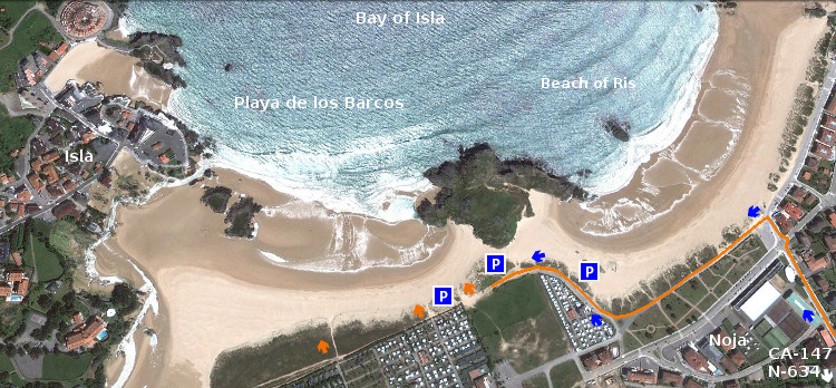
El Sol ocultado por el clima apareció como un oasis en días sueltos. En uno de esos momentos encontré la espontaneidad del arte y el surf. Fue a finales del mes de enero. Tras haber realizado un viaje. En el camino de vuelta a Cantabria, decidí hacer una parada en El Brusco, antes de comer. Pesca, senderismo, surf, playa… Llegar y ver, pensar y sentir, cargar las pilas. Pues el mar allí armoniza la estancia. Estacioné el coche lejos del monte y me puse a andar hacia él. A lo lejos ví un grupo de gente en la arena, el agua en el otro extremo de la imagen. Mirando las olas romper la marea iba tomando volumen. Como de costumbre había buenas olas. De 3 a 6 metros de altura y con una serie practicable. Conforme iba caminando aparecieron surfistas con bodyboard que tras calentar se metieron al agua montando algarabía. Las olas aumentaban de tamaño e iban adquiriendo un recorrido largo. Al llegar al final de la playa en el agua ya había más gente y las vistas se asemejaban a un pequeño parque de atracciones. Me dispuse a subir por el sendero que corona el monte. Así contemplaría toda la escena. Pasé por delante de dos hombres que estaban quietos, mirando y pensando. Al saludarlos me parecieron gente conocida. Sin darme cuenta, por la emoción del momento, que la pasión por el surf a todos nos acerca.

Asomando a la entrada del sendero, volví la vista a la playa. Una ola de 4 metros se acercaba. Quieto, expectante, espere unos segundos que parecieron eternos. Cortando la ola desde un costado apareció un surfer con un bodyboard. La masa de agua fue cayendo y desapareció. Continué mirando esperando otra ola así. Sin saber que lo mejor estaba por llegar. Mire el otro lado de la ola que se había entubado. Vi una figura y sonreí. Salió del tubo y antes de su cierre se catapultó un par de metros en el aire. Hizo una maniobra acompañada de un grito y finalmente aterrizó en el agua.

Regrese a la playa para conversar de surf. Ya no quedaba nadie en el arenal. La figura de uno de los hombres, que antes miraba, se dirigía hacia el agua. Con dos metros de alzada y la tabla de surf sujetada en un brazo. Entró al agua fría y se perdió detrás de las olas. Poco después volví a ver aquella figura. Desde la cresta hasta la base, ondulando el recorrido. Equilibrando su peso con los brazos. Congelando toda aquella imagen en la memoria del ojo que contempla.

El Brusco, An unexpected show

Icono Inglés. Icon English In these final days of winter after two weeks of sunny weather, the remembrance of the storms that struck the Cantabrian coast seems far away.

The meteorological data have revealed us the unusual frequency of storms and explosive cyclogenesis that have been happening since December until February. The amount of water recorded in this period almost tripled the same amount received in twelve months in previous years. The oceanic buoys have captured, with unusual frequency, waves of more than 10 meters and ,in a manner not so exceptional, waves that have exceeded 20 meters. In these conditions the surfing only has been suitable for professionals and experts.

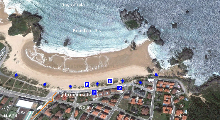
The Sun was hidden by the state of the weather and only emerged as an oasis in loose days . In one of those moments I found the spontaneity of the art and the surf. It was at the end of the month of January. After a trip. On the way back to Cantabria, I decided to make a stop at «El Brusco» before eating. Fishing, hiking, surfing, beach … Come and see, think and feel, to charge the batteries. Because the sea there harmonizes the time. I parked my car far away from the mount and I began to walk toward it. In the distance I saw a group of people in the sand, the water at the other end of the image. The tide was taking volume. As usual there was good waves. From 3 to 6 meters in height and with a practicable series. As I was walking some surfers with bodyboard were enjoying the travel to the water. The waves increased in size and became as a motorway. At the end of the beach in the water there were already more people and the views were analogous to a small amusement park. I began to go up the trail that crown the mount. I wanted to contemplate the whole scene. I passed in front of two men who were perfectly still, looking and thinking. None of us were strangers at that place. We forgot, because of the emotion of the moment, that the passion for surfing met us.

When I was at the entrance of the trail, i returned the view to the beach. A wave of 4 meters was approaching. The watchful waiting was a few seconds that seemed to last forever. By cutting off the wave from the side appeared a surfer with a bodyboard. The mass of water was falling and disappeared. I continued watching waiting for another wave as well. Without knowing that the best was to come. Look at the other side of the wave that had been entubated. I saw a figure and I smiled to myself. The surfer came out of the tube and before its closure he was catapulted two meters in the air. He made a maneuver accompanied by a cry and finally landed in the water.

I came back to the beach to talk about surfing. There was no one in the sand. The figure of one of the men that were thinking there before, were now walking toward the water. With two meters over his feet, and the surfboard in an arm. He entered the cold water and was lost behind the waves. Shortly after I returned to see that figure. From the top to the base, undulating the tour. Balancing his weight with his arms. The experience became an frozen image in the memory.

Separador. DividerIcono Español-Inglés. Icon Spanish-EnglishSurf. El BruscoIcono separador. Icon divider
Icon close Sponsor

Share