Berria, playa
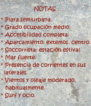
![]() La playa de Berria está ubicada en la zona noroeste del municipio de Santoña. Emplazada entre montes y marisma, mira de frente al Mar Cantábrico. Este gran arenal de 2200 metros de longitud y 150 metros de anchura se encuentra acotado desde el oeste por el monte EL Brusco, desde el este por el macizo del Buciero. Ambos montes impregnan con sus rocas los costados del arenal, transportando al visitante a un tiempo remoto, salvaje y natural. Al sur de la playa hay una basta extensión de 6678 hectáreas que componen El Parque Natural de las Marismas de Santoña, Victoria y Joyel.
La playa de Berria está ubicada en la zona noroeste del municipio de Santoña. Emplazada entre montes y marisma, mira de frente al Mar Cantábrico. Este gran arenal de 2200 metros de longitud y 150 metros de anchura se encuentra acotado desde el oeste por el monte EL Brusco, desde el este por el macizo del Buciero. Ambos montes impregnan con sus rocas los costados del arenal, transportando al visitante a un tiempo remoto, salvaje y natural. Al sur de la playa hay una basta extensión de 6678 hectáreas que componen El Parque Natural de las Marismas de Santoña, Victoria y Joyel.
Berria se ha ido formando a lo largo de los siglos. En la antigüedad Santoña era una isla. Rodeada por el mar, la acumulación de sedimentos en los flancos de la actual playa debido a las corrientes entrantes y salientes, junto con la acción del viento terminaron cerrando la salida del agua. La posterior aparición de formaciones dunáres crearon un istmo que dió origen a la actual playa de Berria.


Berria, beach
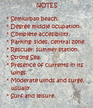
![]() The beach of Berria is located in the northwest zone of the municipality of Santoña. Placed between mounts and marsh, it looks to the Cantabrian Sea. This great sandbank of 2200 meters of length and 150 meters of width is drawn from the west by the mount El Bursco, from the west by the clump of the Buciero. Both mountains impregnate with its rocks the sides of the sandbank, transporting the visitor to a remote, wild and natural time. To the south of the beach there is an extension of 6678 hectares that compose The Nature reserve of Santoña’s Marshes, Victory and Joyel.
The beach of Berria is located in the northwest zone of the municipality of Santoña. Placed between mounts and marsh, it looks to the Cantabrian Sea. This great sandbank of 2200 meters of length and 150 meters of width is drawn from the west by the mount El Bursco, from the west by the clump of the Buciero. Both mountains impregnate with its rocks the sides of the sandbank, transporting the visitor to a remote, wild and natural time. To the south of the beach there is an extension of 6678 hectares that compose The Nature reserve of Santoña’s Marshes, Victory and Joyel.
Berria has been formed throughout the centuries. In the antiquity, Santoña was an island. Surrounded by the sea, the accumulation of sediments in the flanks of the current beach due to the entry and exit currents, together with the action of the wind; them ended up by closing the exit of the water. The later appearance of dunes and vegetation, created an isthmus that gave origin to Berria’s current beach.

