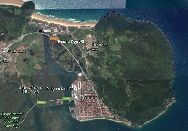
Santoña, ciudad

Icono Español. Icon Spanish Santoña, municipio de la costa oriental de Cantabria, es una pequeña y especial ciudad marinera asentada a los pies de la cara suroeste del Monte Buciero. El 95% de su perímetro está rodeado por agua. Limitando al norte, sur y este con el Mar Cantábrico. En la cara oeste se encuentra las Marismas de Santoña, Victoria y Joyel, Parque Natural cuya extensión supera las 6000 hectáreas. El inmenso área que ocupan las marismas configura el interior del municipio hasta alcanzar la playa de Berria, situada al noroeste. La playa de San Martin, emplazada en la bahía, abarca una gran parte del paseo marítimo de la villa; conocido como El Pasaje.

El Puerto Deportivo dispone en sus cercanías de un Centro de Interpretación del Parque Natural de las Marismas de Santoña. El Puerto Pesquero, anexo al centro de visitantes, delimita con el puente inicia la carretera que atraviesa las marismas y comunica la ciudad por el oeste. Esta carretera nacional es conocida como la «Carretera de los Puentes» y, además de prestar el propio servicio, da acceso al Observatorio de Aves de la Arenilla, el Monte Montehano y otras partes del estuario como la Ría de Argoños. Son sus puertos que miran a la Bahía de Santoña el principio del camino hacia el Mar Cantábrico.

Santoña, city

Icono Inglés. Icon English Santoña, municipality of the oriental coast of Cantabria, is an small and special maritime city seated to the feet of the southwest face of the Buciero Mount. The 95 % of its perimeter is surrounded by water. Bordering to the north, south and east with the Cantabrian Sea. In the west is The Marshland of Victoria and Joyel, Nature reserve which extension overcomes 6000 hectares. The immense area, that the marshes occupy, forms and builds the interior of the municipality up to reaching Berria’s beach, placed to the northwest. San Martin beach, located in the bay, includes a great part of the maritime walk of the villa; acquaintance as El Pasaje.

The Sport marina has, in its surroundings, a Center of Interpretation of the Nature reserve of Santoña’s Marshes. The Fishing port, attached to the visitors’ center, delimits with the bridge that initiates the road which crosses the marshes and communicates the city through the west. This national road is known as the «Road of the Bridges» and, in addiction to giving its own service, leads to the Observatory of Birds of La Arenilla, the Mount Montehano and other parts of the estuary like the Rivermouth of Argoños. They are its ports, that meet and greet with the Bay of Santoña, the beginning of the way at the Cantabrian Sea.

Icon text divider

Santoña, route

Icono español-inglés. Icon Spanish-English. Santoña, city Santoña, ciudad

Santoña, city

icon close cities

Share

El Brusco , lugar

Icono Español. Icon Spanish. El Brusco place EL Brusco es un monte emplazado en el municipio de Noja,en la costa oriental de Cantabria. Situado al final de la playa de Trengandín, tiene una altura de 99 metros y una superficie aproximada de 15 hectáreas. Su arcaica estructura se muestra y esconde al compás de las mareas. Aparecen los cimientos con la bajamar. Intuidos sobre un mosaico compuesto por miles de rocas. Afiladas, troceadas, por el mar tocadas.

Este pequeño monte constituye un emplazamiento singular. Incluido en la formación montañosa de los Montes de Mijedo, es la única zona del macizo que sobresale en la línea de costa y cuya base se asienta en el mar. La ubicación y el medio que lo rodean, han moldeado su perímetro y dibujado su forma, con el paso del tiempo; convirtiendo al monte en frontera natural entre las playas de Trengandín y Berria y los municipios de Noja y Santoña.

A los pies del Brusco comienza una senda que conduce a lo alto del monte, para descender de nuevo hacia el otro lado hasta encontrar la playa de Berria. Transcurre el sendero inundado de vegetación. Robles y hayas predominan en la zona, acompañados de sotobosque. Este paso natural, convertido en senda, tiene una anchura de apenas medio metro. Tras los primeros pasos, las distancias a los puntos contiguos se agrandan, haciendo recordar la civilización como un ruido distante. Acto seguido aparecerá una natural y sencilla melodía, siempre nueva y no obstante; familiar. La brisa marina recorre todo la zona, moviendo la vegetación a su libre albedrío. Desde la cima podremos contemplar Noja y sus extensas playas a la izquierda, pasando por Berria a la derecha, El monte el Buciero y Santoña; después y entre sus marismas a modo de vivo paisaje.

Los días con buenas condiciones, las olas alcanzan los dos metros de altura. Lejos del monte, donde las corrientes son fuertes y forman remolinos, aparecen varios tipos de ola. Abriendo a ambos lados, su recorrido; a través de una tersa pared de agua, es casi constante y prolongado. Favorece las maniobras y salidas limpias .

comic, mountain
El Brusco, notas

El Brusco, place

Icono Inglés. Icon English. El Brusco place El Brusco is a mount located in the municipality of Noja, in the oriental coast of Cantabria. Placed at the end of Trengandín’s beach, it has a height of 99 meters and an approximate surface of 15 hectares. Its archaic structure appears and hides to the compass of the tides. The foundations appear with the low tide. Intuitively on a mosaic composed by thousands of rocks. Sharpened, cut into pieces, as the sea touched them , have touched and will be touched.

This small mount constitutes a singular place. Included in the mountainous formation of Mijedo’s Mounts, it is the only zone of the mountain massif that stands out in the line of coast and has its base in the sea. The location and the environment that surround it, have molded its perimeter and drawn its form with the passage of time; turning to the mountain in a natural border between the beaches of Trengandín and Berria and the municipalities of Noja and Santoña.

At the foot of El Brusco begins a path that comes up to the top, to descend again towards another side up to finding Berria’s beach. The path is flooded with vegetation. Oaks and beeches prevail in the zone, accompanied of undergrowth. This passageway turned into path, has a width of scarcely half a meter. After the first steps, the distances to the contiguous points are enlarged, making remember the civilization as a distant noise. Forthwith a natural and simple melody will appear, always newly and nevertheless; familiar. The marine breeze crosses the zone, moving the vegetation to its free will. From the top we will be able to contemplate Noja and its extensive beaches to the left, shifting for Berria to the right, The mount El Buciero and Santoña; behind and between its marshes like an alive landscape.

The days with good conditions, the waves reach two meters of height. Far from the mount, where the currents are strong and form whirlpools, several types of wave appear. Opening to both sides, its tour; across a smooth wall of water, it is almost constant and long. It favors the maneuvers and clear exits.

comic, mountain
El Brusco, notes

Share

Berria, playa

Icono Español. Icon Spanish La playa de Berria está ubicada en la zona noroeste del municipio de Santoña. Emplazada entre montes y marisma, mira de frente al Mar Cantábrico. Este gran arenal de 2200 metros de longitud y 150 metros de anchura se encuentra acotado desde el oeste por el monte EL Brusco, desde el este por el macizo del Buciero. Ambos montes impregnan con sus rocas los costados del arenal, transportando al visitante a un tiempo remoto, salvaje y natural. Al sur de la playa hay una basta extensión de 6678 hectáreas que componen El Parque Natural de las Marismas de Santoña, Victoria y Joyel.

Berria se ha ido formando a lo largo de los siglos. En la antigüedad Santoña era una isla. Rodeada por el mar, la acumulación de sedimentos en los flancos de la actual playa debido a las corrientes entrantes y salientes, junto con la acción del viento terminaron cerrando la salida del agua. La posterior aparición de formaciones dunáres crearon un istmo que dió origen a la actual playa de Berria.

comic, mountain
Berria beach Santoña, Notas

Berria, beach

Icono Inglés. Icon English The beach of Berria is located in the northwest zone of the municipality of Santoña. Placed between mounts and marsh, it looks to the Cantabrian Sea. This great sandbank of 2200 meters of length and 150 meters of width is drawn from the west by the mount El Bursco, from the west by the clump of the Buciero. Both mountains impregnate with its rocks the sides of the sandbank, transporting the visitor to a remote, wild and natural time. To the south of the beach there is an extension of 6678 hectares that compose The Nature reserve of Santoña’s Marshes, Victory and Joyel.

Berria has been formed throughout the centuries. In the antiquity, Santoña was an island. Surrounded by the sea, the accumulation of sediments in the flanks of the current beach due to the entry and exit currents, together with the action of the wind; them ended up by closing the exit of the water. The later appearance of dunes and vegetation, created an isthmus that gave origin to Berria’s current beach.

comic, mountain
Berria beach Santoña, Notes

Share

Playa de Trengandín, acceso

Icono Español. Icon Spanish. Playa de Trengandín La playa de Trengandín está situada en la Villa de Noja. Ubicada entre Santoña e Isla, en la costa oriental de Cantabria. Con una extensión mayor de seis kilómetros, cuenta con numerosas zonas de aparcamiento que dan acceso directo a la playa. Presenta una agrupación de rocas en su parte central, siendo peligrosa la practica del surf en la zona.

Tregandín beach, access

Icono Inglés. Icon English. Playa de Trengandín Trengandín beach is placed in the Villa of Noja. Located between Santoña and Isla, in the oriental coast of Cantabria. With a major extension of over six kilometres, it has on numerous zones of parking that give direct access to the beach. There are a group of rocks in its central part, being dangerous the practice of the surf in the zone.

Icono español-inglés. Icon Spanish-English. Playa de Trengandín Acceso/Access

Access: playa de Trengandín

Icon close Sponsor

Share

Playa de Trengandín, Localización

Icono Español. Icon Spanish La Playa de Trengandín está situada en la Villa de Noja, en la costa oriental de Cantabria. Tiene una extensión superior a los seis kilómetros. En su parte central, su fondo arenoso se mezcla con abundantes rocas puntiagudas y afiladas, que apenas cubre la pleamar. En esta zona se puede practicar el baño, la pesca y el submarinismo, siendo peligrosa la práctica del surf. Se puede llegar a esta playa desde Oviedo, Palencia, Santander o Bilbao, como ciudades adyacentes. Todos los trayectos finalizan por la carretera nacional CA-147.

Beach of Trengandín, localization

Icono Inglés. Icon English Beach of Trengandín is placed in the Villa of Noja, on the oriental coast of Cantabria. It has an lenght over six kilometres. In its central part, its sandy bottom is mixed by abundant sharp-pointed and sharp rocks which the high tide scarcely covers. In this zone it is possible to practise the bath, the fishing and the scuba diving, being dangerous the practice of the surf. It is possible to come to this beach from Oviedo, Palencia, Santander or Bilbao, as adjacent cities. All the routes finish for the national road CA-147.

Icono Español-Inglés. Icon Spanish-English Localización/Localization

Oviedo,Playa de Trengandín: localizationPalencia, Playa de Trengandín: localizationBilbao, Playa de Tregandín: localizationSantander, Playa de Trengandín: localization

Icon close Sponsor

Share

Berria, localización

Icono Español. Icon Spanish Esta especial playa se ubica en el municipio de Santoña. Es una playa que se encuentra en el istmo que une la península que forma el monte Buciero (en Santoña) con el municipio de Argoños. A través de la carretera CA-907 se accede finalmente a la playa, tanto desde Santoña como desde Argoños.

Berria Beach, Localization

Icono Inglés. Icon English Berria beach is located in the town of Santoña. It is a beach which is placed in the isthmus that connects the peninsula forming the Buciero Mount (in Santoña) with the municipality of Argoños. Through the national road CA-907 you can finally access to the beach, from Santoña or Argoños.

Icono Español-Inglés. Icon Spanish-English Localización/Localization

Oviedo,Berria-beach: LocalizationPalencia,Berria-beach: LocalizationBilbao,Berria-beach: LocalizationSantander,Berria-beach: Localization

Icon close Sponsor

Share