Prellezo, villa

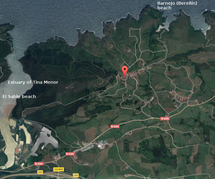
Icono Español. Icon Spanish. Prellezo, villa, village Prellezo es una pequeña y hermosa localidad situada en la costa occidental de Cantabria y perteneciente al municipio de Val de San Vicente. Su baja densidad de población contrasta con su extensión, lo que la convierte en un destino ideal para disfrutar de la naturaleza salvaje y alejada del ruido mundano.

Prellezo presenta su patrimonio al caminante, destacando un yacimiento arqueológico descubierto recientemente y cuya antiguedad se data entre el paleolítico inferior y el mesolítico. Conocido como El Castro del Castillo, cuenta con una localización costera y comunicada con tierra firme por un istmo. Las dos hectáreas del promontorio descansan sobre rasa mareal y esta protegido por el mar y construcciones defensivas.

La riqueza natural y paisajística de Prellezo, compuesta por praderas y montes, es potenciada por el marco litoral que la delimita. La combinación que crea la costa con los prados amalgama la esencia de la zona que adquiere mayor expresión sensorial a través de las ensenadas, acantilados, calas y rocas. La Ría de Tina Menor proporciona un espacio de gran riqueza biológica, perceptible en varios aspectos desde cualquier punto, pues el trasiego de las mareas permite la diversidad y emociona a la tierra.

Icono Inglés. Icon English. Prellezo, villa, village Prellezo is an small and beautiful locality placed in the western coast of Cantabria and belonging to the municipality of Val de San Vicente. Its low density of population contrast with its extension, which turns it into an ideal destination to enjoy the nature wild and far from the worldly noise.

Prellezo presents its heritage to the wayfarer, emphasizing an archaeological deposit discovered recently and whose exage is dated between the low Paleolithic and the Mesolithic. Acquaintance as The Castro of Castillo, possesses a coastal location and communicated with mainland through an isthmus. The two hectares of the promontory rest on tidal plain, protected by the sea and defensive constructions.

Prellezo’s natural and landscape wealth, composed for meadow and mounts, is strengthened by the coastal frame that delimits it. The combination that creates the coast with the meadows amalgamates the essence of the zone that acquires major sensory expression across the inlets, cliffs, coves and rocks. The Estuary of Tina Menor provides a space with great biological wealth, perceptible in several aspects from any point, due to the decanting of the tides that allows the diversity and thrills the land.

 Prellezo, villa, village. Icon text divider

Prellezo, routes

Icono español-inglés. Icon Spanish-English. Prellezo, villa, village. Map Prellezo, village

Prellezo, map

 Prellezo, villa, village. icon close cities

Share

Suances, villa

Icono Español. Icon Spanish. Suances, villa, village Suances es un municipio y capital municipal situado en el extremo occidental de la costa central de Cantabria. Su población que sobrepasa los 8500 habitantes, ocupa un extenso territorio que comprende varias localidades y se extiende desde la costa hasta el interior.

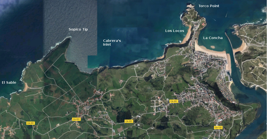
Su costa comienza en la desembocadura del Río Saja, donde se localiza la playa de La Concha y la Punta del Torco. Atravesando la Ensenada de Cabrera que contiene a las playas de Los Locos y la Tablía, se alcanza Punta Ballota y detrás la playa El Sable, donde finaliza la costa del municipio. La línea de costa dispone un recorrido sobre acantilados y playas, con sendas practicables en la mayor parte del recorrido. Destaca la Punta del Torco, una península que separa las dos ensenadas del municipio y ofrece una visión panorámica de toda esta costa.

Suances es un villa turística por excelencia, predominando edificios de nueva construcción para zona residencial y ocupación estival. La riqueza arquitectónica de la zona es variada, destacando la arquitectura religiosa con edificios como la Iglesia de Suances del siglo XVII. La arquitectura civil cuenta con varias casas señoriales, Casa de los Polanco, palacios, Castillo de Florencio Ceruti y restos de construcciones defensivas costeras así como la Casa del Ayuntamiento.

Suances, village

Icono Inglés. Icon English. Suances, villa, village Suances is a municipality and the municipal capital placed in the western end of the central coast of Cantabria. Its population who exceeds 8500 inhabitants, occupies an extensive territory that covers several localities and spreads from the coast up to the interior.

Its coast begins in the river mouth of the Saja, where there is located the beach of La Concha and the Point of the Torco. Crossing Cabrera’s Inlet that it contains the beaches of Los Locos and the Tablía, is reached Ballota’s Tip and behind the beach The Sable, where finishes the coast of the municipality. The line of coast arranges a tour over cliffs and beaches, with practicable paths in most of the tour. Stands out the Point of the Torco, a peninsula that separates both inlets of the municipality and offers a panoramic vision of all this coast.

Suances is a tourist excellent villa, predominating over buildings of new construction for residential zone and summer occupation. The architectural wealth of the zone is varied, emphasizing the religious architecture with buildings as Suances’s Church; of the 17th century. The civil architecture possesses several lordly houses, House of the Polanco, palaces, Florencio Ceruti’s Castle, remains of defensive coastal constructions as well as the Town hall.

Suances, villa, village. Icon text divider

Suances, routes

Icono español-inglés. Icon Spanish-English. Suances, villa, village. Map Suances, village

suances, map

Suances, villa, village. icon close cities

Share

EL Sable, playa

Icono Español. Icon Spanish. El Sable, playa El Sable es una playa situada en la localidad de Prellezo, perteneciente al municipio de Val de San Vicente. Emplazada en el interior de la Ría de Tina Menor, su fisonomía está determinada por el trasiego de las mareas y la configuración del estuario.

El Sable, playa de 350 metros de longitud y apenas 10 metros de anchura media, es un pequeño y particular arenal. Localizada entre la desembocadura del Río Nansa y el cierre de la Ría de Tina Menor, disponen de aguas tranquilas y protegidas de mar abierto. Su entorno natural y salvaje se encuentra poblado de bosque atravesado por senderos. El lado derecho de la ría que ocupa la playa es transitable en marea baja hasta su final y al encuentro con el mar. La tranquilidad natural que reina en la zona convierten la estancia en un reconstituyente descanso.

El otoño trae consigo las grandes mareas, removiendo el fondo de arena y arcilla. Tiñe la zona de color beige y deposita nuevos sedimentos que alimentan la diversidad biológica presente. La primavera hace regresar las aves y completa un sistema que puede ser disfrutado desde la playa de El Sable.

Cabecera Cities Place Beaches . El Sable, playa
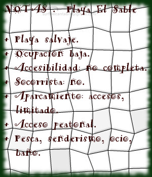
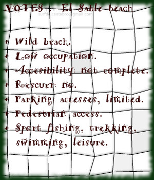
El Sable, notas

El Sable, beach

Icono Inglés. Icon English. El Sable, beach El Sable is a beach placed in the locality of Prellezo, belonging to the municipality of Val de San Vicente. Located inside the Estuary of Tina Menor, its physiognomy is determined by the decanting of the tides and the configuration of the tidal river.

El Sable, beach of 350 meters of length and just 10 meters of average width, is an small and particular sandbank. Located between the river mouth of the Nansa River and the closing of Tina Menor, it has calm waters and protected from open sea. Its natural and wild environment is populated of forest crossed by paths. The right side of sea inlet that occupies the beach, it is pasable in low tide until its end and to the meeting with the sea. The natural tranquility that reigns in the zone, turns the stay into a restorative rest.

The autumn brings with it the big tides, removing the bottom of sand and clay. It dyes the zone of beige color and new sediments are despositated that feed the present biological diversity. The spring makes return the birds and completes a system that can be enjoyed from the beach of El Sable.

Cabecera Cities Place Beaches. El Sable, beach
El Sable, notes

Share