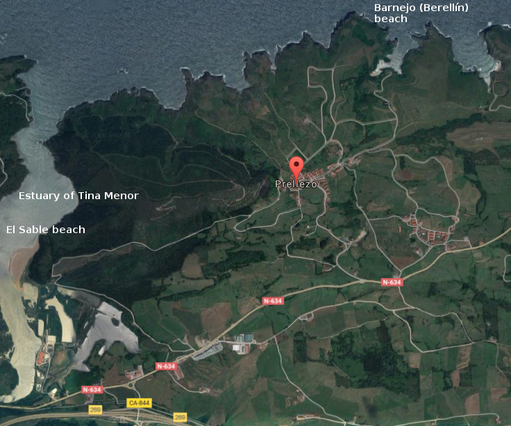
Prellezo, villa

Icono Español. Icon Spanish. Prellezo, villa, village Prellezo es una pequeña y hermosa localidad situada en la costa occidental de Cantabria y perteneciente al municipio de Val de San Vicente. Su baja densidad de población contrasta con su extensión, lo que la convierte en un destino ideal para disfrutar de la naturaleza salvaje y alejada del ruido mundano.

Prellezo presenta su patrimonio al caminante, destacando un yacimiento arqueológico descubierto recientemente y cuya antiguedad se data entre el paleolítico inferior y el mesolítico. Conocido como El Castro del Castillo, cuenta con una localización costera y comunicada con tierra firme por un istmo. Las dos hectáreas del promontorio descansan sobre rasa mareal y esta protegido por el mar y construcciones defensivas.

La riqueza natural y paisajística de Prellezo, compuesta por praderas y montes, es potenciada por el marco litoral que la delimita. La combinación que crea la costa con los prados amalgama la esencia de la zona que adquiere mayor expresión sensorial a través de las ensenadas, acantilados, calas y rocas. La Ría de Tina Menor proporciona un espacio de gran riqueza biológica, perceptible en varios aspectos desde cualquier punto, pues el trasiego de las mareas permite la diversidad y emociona a la tierra.

Icono Inglés. Icon English. Prellezo, villa, village Prellezo is an small and beautiful locality placed in the western coast of Cantabria and belonging to the municipality of Val de San Vicente. Its low density of population contrast with its extension, which turns it into an ideal destination to enjoy the nature wild and far from the worldly noise.

Prellezo presents its heritage to the wayfarer, emphasizing an archaeological deposit discovered recently and whose exage is dated between the low Paleolithic and the Mesolithic. Acquaintance as The Castro of Castillo, possesses a coastal location and communicated with mainland through an isthmus. The two hectares of the promontory rest on tidal plain, protected by the sea and defensive constructions.

Prellezo’s natural and landscape wealth, composed for meadow and mounts, is strengthened by the coastal frame that delimits it. The combination that creates the coast with the meadows amalgamates the essence of the zone that acquires major sensory expression across the inlets, cliffs, coves and rocks. The Estuary of Tina Menor provides a space with great biological wealth, perceptible in several aspects from any point, due to the decanting of the tides that allows the diversity and thrills the land.

 Prellezo, villa, village. Icon text divider

Prellezo, routes

Icono español-inglés. Icon Spanish-English. Prellezo, villa, village. Map Prellezo, village

Prellezo, map

 Prellezo, villa, village. icon close cities

Share

Barnejo, playa

Icono Español. Icon Spanish. Barenjo, playa La playa de Barnejo, también llamada playa de Berellín, se encuentra en la localidad de Prellezo, perteneciente al municipio de Val de San Vicente. Emplazada en la costa occidental de Cantabria, de reducidas dimensiones, descubre un área singular de especial belleza.

La Punta del Morro de Berellín y la Punta de África, dos pequeños cabos que se ubican en la zona, delimitan la Ensenada de Berellín. La playa está contenida en la ensenada que compuesta por formaciones kársticas y un dibujo libre e irregular de la costa va abriendo la entrada al mar a través de sus acantilados. Apenas 100 metros en la parte más ancha, crean un canal que serpentea a lo largo de casi 800 metros de longitud.

El diferente y potente paisaje que rodea a la playa, estimula los sentidos que por los senderos van descubriendo la zona. Las aguas tranquilas y de color verdoso traslucen el fondo arenoso que invita a disfrutar de un relajado baño. El amanecer, su atardecer, el mediodía se convierten en diferentes y buenos perfiles de una misma postal.

Cabecera Cities Place Beaches . Barnejo, playa
Barnejo, notas

Barnejo, beach

Icono Inglés. Icon English. Barnejo, beach Barnejo beach, also called the beach of Berellín, is in the locality of Prellezo, belonging to the municipality of Val de San Vicente. Located on the western coast of Cantabria, with limited dimensions, it discovers a singular area of special beauty.

The Tip of El Morro de Berellín and the Tip of Africa, two small capes that are located in the zone, delimit Berellín’s Inlet. The beach is contained in the inlet that composed by karst formations and with a free and irregular drawing of the coast, opens the entry to the sea across its cliffs. Hardly with 100 meters in the broadest part, believe a channel that winds along almost 800 meters of length.

The different and powerful landscape that is around the beach, stimulates the senses that through the paths are discovering the zone. The calm waters and of greenish color reveal the sandy bottom that invites to enjoy a relaxed bathe. The dawn,the sunset afternoon, the midday turn into different and good profiles of the same postcard.

Cabecera Cities Place Beaches. Barnejo, beach
Barnejo, notes

Share

Playa del Sable, acceso

Icono Español. Icon Sapnish. La Playa del Sable está situada en la localidad de Prellezo, perteneciente al municipio de Val de san Vicente. Esta playa se ubica en la costa occidental de Cantabria, dentro de la Ría de Tina Menor. Apta para el baño y el disfrute de la naturaleza. Al norte de la playa, a 600 metros aproximadamente, confluyen el Mar y la entrada a la Ría. Allí las corrientes son más fuertes. Cuenta con dos accesos directos a la playa y pequeñas zonas utilizas a modo de aparcamiento, a 300 metros del arenal.

Beach of the Sable, access

Icono Inglés. Icon English. The Beach of the Sable is placed in the locality of Prellezo, belonging to the municipality of Val de San Vicente. This beach is located on the western coast of Cantabria, inside the Estuary of Tina Menor. Suitable for the swiming and the enjoyment of the nature. To the north of the beach, to 600 meters approximately, the Sea and the entry of the Estuary meet together. There, the currents are stronger. It possesses two direct accesses to the beach and small zones that you can use like parking, to 300 meters of the sandbank.

Icono español-inglés. Icon Spanish-English. Acceso/Access

Playa del Sable: access

Share

Playa del Sable, localización

Icono Español. Icon Spanish La Playa del Sable se encuentra en la localidad de Prellezo, perteneciente al municipio de Val de San Vicente; en la costa occidental de Cantabria. Debido a que esta zona no aparece en las guías oficiales, La ruta finaliza a unos metros de la carretera que conduce a la playa. Después de atravesar la rotonda, la segunda salida a la izquierda de la carretera, nos lleva hasta el arenal. Se muestran a continuación como puntos de partida: Oviedo, Palencia, Santander y Bilbao. Comenzando el viaje por autovía y finalizando el recorrido por la misma carretera nacional en todos los trayectos.

Beach of the Sable, localization

Icono Inglés. Icon English The Beach of the Sable is in the locality of Prellezo, belonging to the municipality of Val de San Vicente; on the western coast of Cantabria. Due to this zone does not appear in the official guides, the route finishes to a few meters of the road that leads to the beach. After crossing the roundabout, the second exit to the left of the road, will takes us up to the sandbank. Shown below as starting points: Oviedo , Palencia , Santander and Bilbao . Beginning the trip for motorway and finishing the tour for the same national road in all the options.

Icono Español-Inglés. Icon Spanish-English Localización/Localization

Oviedo, Beach of the Sable: LocalizationPalencia, Beach of the Sable: localizationBilbao, Beach of the Sable: localizationSantander, Beach of the Sable: localization

Share