Suances, villa

Icono Español. Icon Spanish. Suances, villa, village Suances es un municipio y capital municipal situado en el extremo occidental de la costa central de Cantabria. Su población que sobrepasa los 8500 habitantes, ocupa un extenso territorio que comprende varias localidades y se extiende desde la costa hasta el interior.

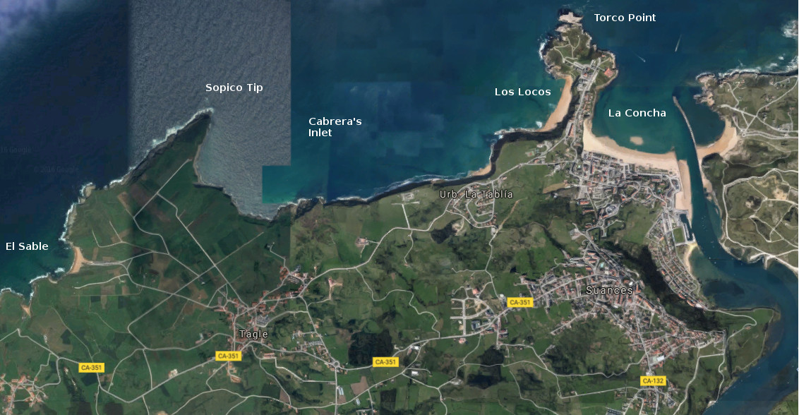
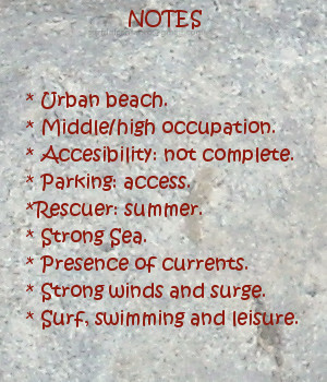
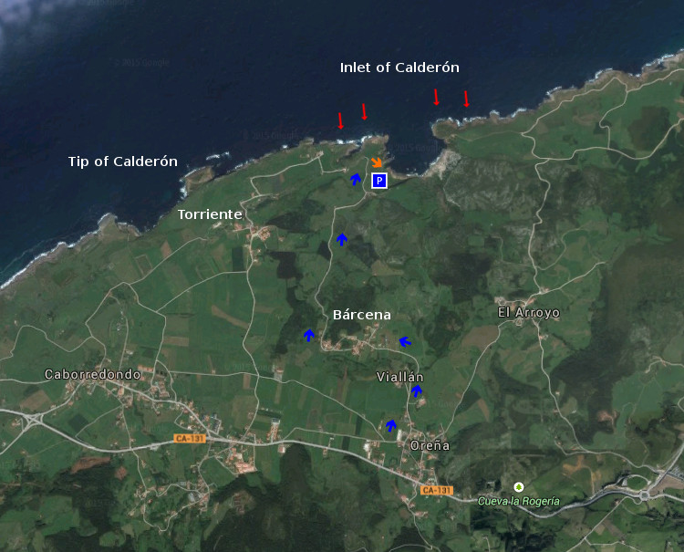
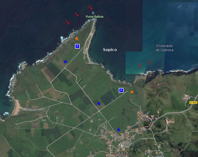
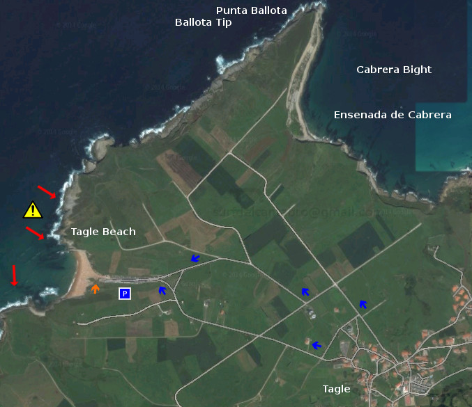
Su costa comienza en la desembocadura del Río Saja, donde se localiza la playa de La Concha y la Punta del Torco. Atravesando la Ensenada de Cabrera que contiene a las playas de Los Locos y la Tablía, se alcanza Punta Ballota y detrás la playa El Sable, donde finaliza la costa del municipio. La línea de costa dispone un recorrido sobre acantilados y playas, con sendas practicables en la mayor parte del recorrido. Destaca la Punta del Torco, una península que separa las dos ensenadas del municipio y ofrece una visión panorámica de toda esta costa.

Suances es un villa turística por excelencia, predominando edificios de nueva construcción para zona residencial y ocupación estival. La riqueza arquitectónica de la zona es variada, destacando la arquitectura religiosa con edificios como la Iglesia de Suances del siglo XVII. La arquitectura civil cuenta con varias casas señoriales, Casa de los Polanco, palacios, Castillo de Florencio Ceruti y restos de construcciones defensivas costeras así como la Casa del Ayuntamiento.

Suances, village

Icono Inglés. Icon English. Suances, villa, village Suances is a municipality and the municipal capital placed in the western end of the central coast of Cantabria. Its population who exceeds 8500 inhabitants, occupies an extensive territory that covers several localities and spreads from the coast up to the interior.

Its coast begins in the river mouth of the Saja, where there is located the beach of La Concha and the Point of the Torco. Crossing Cabrera’s Inlet that it contains the beaches of Los Locos and the Tablía, is reached Ballota’s Tip and behind the beach The Sable, where finishes the coast of the municipality. The line of coast arranges a tour over cliffs and beaches, with practicable paths in most of the tour. Stands out the Point of the Torco, a peninsula that separates both inlets of the municipality and offers a panoramic vision of all this coast.

Suances is a tourist excellent villa, predominating over buildings of new construction for residential zone and summer occupation. The architectural wealth of the zone is varied, emphasizing the religious architecture with buildings as Suances’s Church; of the 17th century. The civil architecture possesses several lordly houses, House of the Polanco, palaces, Florencio Ceruti’s Castle, remains of defensive coastal constructions as well as the Town hall.

Suances, villa, village. Icon text divider

Suances, routes

Icono español-inglés. Icon Spanish-English. Suances, villa, village. Map Suances, village

suances, map

Suances, villa, village. icon close cities

Share

Sopico, lugar

Icono Español. Icon Spanish. Sopico, lugar Sopico, emplazamiento localizado en la localidad de Suances, es un pequeño cabo que separa las playas de Los Locos y La Tablía. La marea baja descubre las rocas que se apilan en la base del acantilado, quedando la arena cubierta por el agua.

Al acceso a este punto de olas se realiza por las playas colindantes. Destacan las fuertes corrientes y el oleaje, proporcionando olas prácticamente durante todo el año. La ola característica de Sopico abre a izquierdas, manteniendo la misma calidad sin importar las mareas. Aparecen olas cortas y maniobrables, alternadas con olas más profundas y de recorrido medio/largo. Debido a sus características tiene una ocupación alta, siendo exigido respetar las normas y turnos.

La cima de Sopico cuenta con un mirador panorámico que abre al caminante la amplitud de la Ensenada de Cabrera. La La contemplación del entorno recorre desde Suances a la derecha hasta Punta Ballota cerrando extremo izquierdo, entreteniendo la mirada sobre el horizonte; que mostrará la naturaleza del Mar Cantábrico.

Cabecera Cities Place Beaches . Sopico, lugar
Sopico, notas

Sopico, place

Icono Inglés. Icon English. Sopico, lugar Sopico, emplacement located in the locality of Suances, is a small end that separates the beaches of Los Locos and La Tablía. The low tide discovers the rocks that are piled up in the base of the cliff, staying the sand covered by the water.

The access to that point of waves it is realized by the adjacent beaches. The strong currents and the surge stand out, providing waves practically all the year round. The wave typical Sopico’s opens to left sides, supporting the same quality without importing the tides. There appear short and manoeuvrable waves alternated with deeper waves and of meium tour. Due to its characteristics it has a high occupation, being demanded the respect to the procedure and shifts.

The top of Sopico has a panoramic viewing-point that opens the wayfarer the extent of Cabrera’s Inlet. The contemplation of the environment crosses from Suances to the right up to Ballota Tip closing the left wing, entertaining the look on the horizon; that will show the nature of the Cantabrian Sea.

Cabecera Cities Place Beaches. Sopico, place
Sopico, notes

Share

Tagle, playa

Icono Español. Icon Spanish. Tagle, playa La playa de Tagle, llamada Playa El Sable, se encuentra en la localidad de Tagle, perteneciente al municipio de Suances, en la costa occidental de Cantabria. El arenal de 200 metros de longitud y 50 metros de ancho, está precedido por un gran aparcamiento que es ocupado totalmente en la estación estival.

La llegada a la playa de Tagle encuentra una cuesta con una pendiente suave, cada paso del caminante se ve ayudado por la inclinación. Poco a poco la zona aumenta su anchura para ir descubriendo la playa, sus laterales, las rocas dispersas dentro de sus aguas. El sonido del Mar Cantábrico, chocando con la Playa EL Sable, entona una melodía que expresa el carácter de la unión entre ambos. Música suave y atrayente ó violenta y natural, ambos estados registra la playa de Tagle.

Los laterales y fondo rocoso la convierten en una playa peligrosa para la práctica del surf. La zona hábil para navegar se encuentra alejada de la línea de costa, evitando las zonas rocosas y situada fuera de la ensenada que forma la playa con el entorno. Las rocas que restan en la zona constituyen la base de la prehistórica y ancestral costa. El efecto de la fuerza del oleaje y las grandes mareas han ido erosionando y afilando los acantilados que son los vestigios que ahora quedan, a modo de entorno rocoso.

Cabecera Cities Place Beaches. Tagle, playa
Tagle, notas

Tagle, beach

Icono Inglés. Icon English. Tagle, beach Tagle’s beach, also called Beach El Sable, is in the locality of Tagle, belonging to the municipality of Suances, on the western coast of Cantabria. The sandbank of 200 meters of length and 50 meters of width, is preceded by a great parking which is totally occupied on the summer station.

The arrival to Tagle’s beach finds a slope with a soft slope, every step of the wayfarer meets helped by the inclination. Little by little the zone increases its width to discover the beach, its wings, the dispersed rocks inside its waters. The sound of the Cantabrian Sea, shocking the Beach El Sable, intones a melody that expresses the character of the union between them. Soft and attractive music or violent and natural, both conditions are register in Tagle’s beach.

The wings and bottom turn her into a dangerous beach for the practice of the surf. The skilful zone to sail is removed from the coast line, avoiding the rocky areas and placed out of the inlet that forms the beach with the environment. The rocks that remain in the zone constitute the base of the prehistoric and ancient coast. The effect of the force of the surge and the big tides have been eroding and sharpening the cliffs that are the vestiges that now stay, like rocky environment.

Cabecera Cities Place Beaches. Tagle, beach
Tagle, notes

Share

La Tablía, playa

Icono Español. Icon Spanish. La Tablía, playa La playa La Tablía, también llamada El Huerto, se encuentra en el municipio de Suances, en el extremo oeste de la costa central de Cantabria. Esta pequeña playa, de 80 metros de longitud y una anchura media de apenas 10 metros, es cubierta prácticamente en su totalidad con la marea alta. Separada de la Playa de Los Locos por la Punta de Sopico, disfruta de la misma calidad de olas que su playa hermana mayor y más conocida, con algunas variaciones y características propias.

Descansando en la base de los acantilados que delimitan la costa de Suances, este punto con forma curvada, pendiente practicable y cubierta de vegetación, dispone de un sendero que da acceso a la cala. Tras el descenso, las abundantes rocas del pequeño arenal hacen indicar que el punto adecuado para practicar surf se encuentra a 150 metros de la orilla, aproximadamente. La presencia de rocas en el área, la cercanía del acantilado y la fuerza del mar aconsejan extremar las precauciones. Evitar la cercanía de la costa en la parte final de la navegación es recomendable. La ola de La Tablía abre a derechas y dispone un viaje largo. Su recorrido favorece el contacto con la pared de la ola, las maniobras para continuar el trayecto. El viento, la energía del Mar Cantábrico, y la morfología del fondo marino que existen en la zona moldean la potencia y forma de las olas.

Llegar a La Tablía, desde el mirador que eternamente la divisa; ver el estado de la mar, para decidir entrar y, en ese caso, cambiar la perspectiva a través de la estancia en sus aguas, en sus olas. En cada trayecto la contemplación del ondulante movimiento de la superficie de sus aguas, que quizás; darán paso al nacimiento de una nueva ola.

Cabecera Cities Place Beaches. La tablía, playa
La Tablia, Notas

Isla, beach

Icono Inglés. Icon English. La Tablía, beach The beach of La Tablía, also called El Huerto, is in the municipality of Suances, in the extreme west of the central coast of Cantabria. This small beach, it has 80 meters of length and an average width of 10 meters, is covered practically in its entirety with the high tide. Separated from the Beach of Los Locos by Sopico Tip, it enjoys the same quality of waves than its relates major and more known beach, with some variations and own characteristics.

Resting in the base of the cliffs that delimit Suances’s coast, this point with curved form, practicable slope and covered with vegetation; has a path that leads to the cove. After the descent, the abundant rocks of the small sandbank indicate that the suitable point to practise surf is to 150 meters of the shore, approximately. The rocks presence in the area, the nearness of the cliff and the force of the sea, advise to carry to extremes the precautions. To avoid the nearness of the coast in the final part of the navigation is advisable. The wave of La Tablía opens to right and arranges a long trip. Its tour favors the contact with the wall of the wave, the maneuvers to continue the journey. The wind, the energy of the Cantabrian Sea, and the morphology of the sea bed that exist in the zone; mould the power and form of the waves.

Arrive at La Tablía, from the viewing-point that eternally has fun with it; to see the condition of the Sea, to decide to enter and, in this case, to change the perspective across the stay into its waters, into its waves. In every journey, the contemplation of the undulating movement of the surface of its waters, that probably; will give step to the birth of a new wave.

Cabecera Cities Place Beaches. La Tablía, beach
La Tablia, Notes

Share

Los Locos, playa

Icono Español. Icon Spanish. Los Locos playa La playa de Los Locos está situada en el municipio de Suances, en la costa central de Cantabria. Su longitud aproximada de 500 metros y anchura media de 20 metros constituye el emplazamiento natural donde terminan las olas que entran a la Ensenada de Cabrera. Es Los Locos una playa urbana que presenta cierto aislamiento debido a su ubicación. Localizada a los pies de los acantilados que unen Suances con la Punta del Dichoso y forman estos una península que hace de cierre y acota su ala este.

Es una de las zonas de la costa cántabra que presenta olas durante todo el año. El fuerte oleaje y la presencia de vientos contribuyen a la calidad de sus ondas. El pico central adquiere buen tamaño, 2 metros aproximadamente. Cercano al ala oeste, abre a ambos lados. Destacando su salida izquierda que puede alcanzar largo recorrido con presencia de tubos.

El acceso al arenal se realiza por un pronunciado desnivel a través de la calzada que hay habilitada. En el momento del descenso, es cuando veremos la playa. Percibiendo sus dimensiones reales y naturaleza propia que van más allá de las palabras. Alzando la vista, ante el caminante, aparece una visión panorámica de toda la zona. La avalancha de estímulos e información dan paso al sencillo disfrute de los sentidos. Cuando los atardeceres son coloreados, y el olor del Mar Cantábrico inunda las inmediaciones de la playa de Los Locos, comienza la hora de los sueños que algún amanecer podrá plasmar.

comic, mountain
Los Locos, notas

Los Locos, beach

Icono Inglés. Icon English. Los Locos beach The beach of Los Locos is placed in the municipality of Suances, in the central coast of Cantabria. Its approximate length of 500 meters and average width of 20 meters constitutes the natural emplacement where finish the waves that enter to the Inlet of Cabrera. It is The Madmen an urban beach that presents certain isolation due to its location. Located to the feet of the cliffs that joins Suances with El Dichoso Tip, these form a peninsula that it does of closing and protect its east wing.

It is one of the zones of the Cantabrian coast that presents waves all the year. The strong surge and the wind presence contribute to the quality of its waves. The central break acquires good size, 2 meters approximately. It rise near the west wing, and opens to both sides. Emphasizing its left path that can reach an important length with presence of pipes.

The access to the sandbank is realized by a pronounced slope across the causeway that has been enabled. In the moment of the descent, is when we will see the beach. Perceiving its real dimensions and own nature that go beyond the words. Lifting the sight, in front of the wayfarer, appears a panoramic vision of the whole zone. The avalanche of stimuli and information give step to the unassuming enjoyment of the senses. When the late afternoons are colored, and the smell of the Cantabrian Sea floods the surrounding areas of Los Locos beach, begins the hour of the dreams that some dawn will be able to form.

comic, mountain
Los Locos notes

Share

Puerto Calderón, acceso

Icono Español. Icon Spanish. Puerto Calderón, acceso El Puerto de Calderón es una ensenada natural situada en el municipio de Alfoz de Lloredo. Rodeada de acantilados y con un pequeño muelle en su base, cuenta con unas condiciones idóneas para practicar submarinismo. El ocio, la pesca y el entretenimiento adquieren mayor significado en este marco incomparable. Tiene un único acceso, a través de la carretera que llega desde el pueblo de Bárcena hasta la ensenada. Donde termina la carretera, hay un pequeño aparcamiento situado a 100 metros de la entrada.

Calderón Port, access

Icono. Icon. Calderón Port, access The Port of Calderón is a natural inlet placed in the municipality of Alfoz de Lloredo. Surrounded with cliffs and a small wharf in its base, it possesses suitable conditions to practise . The leisure, the fishing and the entertainment acquire major meaning in this incomparable frame. There is one only access, across the road that comes from the town of Bárcena up to the inlet. Where the road finishes, there is a small parking placed to 100 meters of the entry.

Icono español-inglés. Icon Spanish-English. Calderón Puerto, Port; acceso/access Acceso/Beach Access

Puerto Calderón, Calderón Port, inlet

Share

Puerto Calderón, localización

Icono Español. Icon Spanish. Puerto Calderón. Calderón Port El Puerto de Calderón está situado en el municipio de Alfoz de Lloredo. Es una ensenada rodeada de acantilados que cuenta con unas condiciones excepcionales para la práctica del submarinismo. También apta para el baño y la pesca, conserva un entorno natural semisalvaje. Atrevesaremos las localidades de Oreña y Bárcena, después seguiremos la carretera hasta la costa, para arrivar a este idílico paraje. Se puede llegar a esta playa desde Oviedo, Palencia, Santander o Bilbao.

Calderón Port, Localization

Icono Inglés. Icon English. Calderón Port. Puerto Calderón The Port of Calderón is placed in the municipality of Alfoz de Lloredo. It is an inlet surrounded with cliffs that possesses a some exceptional conditions for the practice of the scuba diving. Also suitable for the swimming and the fishing, preserves a natural semiwild environment. We will run across the localities of Oreña and Bárcena, then we will continue the road to the cost, to arrive to this idyllic place. It is possible to arrive to this beach from Oviedo, Palencia, Santander or Bilbao.

Icono Español-Inglés. Icon Spanish-English. Puerto Calderón. Calderón Port Localización/Localization

Oviedo, Puerto Calderón: localizationnPalencia, Puerto Calderón: LocalizationBilbao, Puerto Calderón: LocalizationSantander, Puerto Calderón: Localization

Share

Sopico, acceso

Icono Español. Icon Spanish Sopico es un spot ubicado entre acantilados. Punta Ballota, extremo de esta parte de la costa cántabra, protege la Ensenada de Cabrera del mar abierto y contribuye a crear esta especial zona de surf. El acceso hasta el agua es difícil, descendiendo por una parte donde la pendiente es menos pronunciada. Cuenta con pequeñas zonas de aparcamiento y no disponen de ningún servicio en sus proximidades. Sopico es una zona que mantiene un estado salvaje y natural, donde el Mar Cantábrico brinda una larga ola de izquierdas, con presencia de tubos.

Nota: Zona de acceso peligroso y fondo rocoso.

Sopico, access

Icono Inglés. Icon English Sopico is a spot located between cliffs. Ballota Tip, the end of this part of the Cantabrian coast, protects the Inlet of Cabrera of the open sea and contributes to create this special zone of surf. The access up to the water is difficult, descending on one hand where the slope is less pronounced. It possesses small zones of parking and it have not any service in its proximities. Sopico is a wild and natural zone, where the Cantabrian Sea offers a long left-hander wave, with presence of pipes.

Note: zone of dangerous access and rocky bottom.

Icono Español-Inglés. Icon Spanish-English Acceso/Access

Sopico: access

Icon close Sponsor

Share

Sopico, localización

Icono Español. Icon Spanish Sopico está situado en la localidad de Tagle, perteneciente al ayuntamiento de Suances. Debido a que este punto no aparece en las guías oficiales, el trayecto finaliza en el pueblo de Tagle. Desde allí seguimos la carretera hacia la costa; hasta llegar a la Punta de Sopico. Se muestran a continuación como puntos de partida Oviedo, Palencia, Santander y Bilbao. Debido a la complejidad del emplazamiento, el trayecto finaliza en las proximidades de la playa. Continuando el viaje en dirección a la costa, hallaremos la playa.

Sopico, localization

Icono Inglés. Icon English Sopico is placed in the locality of Tagle, belonging to the municipality of Suances. Due to the fact that this point does not appear in the official guides, the route finishes in the town of Tagle. From there we follow the road towards the coast; up to coming to Sopico Tip. Shown below as starting points Oviedo, Palencia, Santander and Bilbao. Due to the complexity of the emplacement, the travel finishes in the proximities of the beach. Continuing the trip towards the coast, we will find the beach.

Icono español-inglés. Icon Spanish-English Localización/Localization

Oviedo, Sopico: LocalizationPalencia, Sopico: localizationBilbao, Sopico: LocalizationSantander, Sopico: Localization

Share

Playa de Tagle, acceso

Icono Español. Icon Spanish. Playa de tagle, acceso La playa de Tagle está situada en la localidad de Tagle, que se ubica dentro del municipio de Suances, en la costa occidental de Cantabria. Atravesando el pueblo se llega a la playa, el acceso está bien señalizado. Cuenta con una amplia zona de aparcamiento que finaliza en la entrada del arenal.

Beach of Tagle, access

Icono Inglés. Icon English. Playa de tagle, access The beach of Tagle is placed in the locality of Tagle, which is located inside Suances’s municipality, in the western coast of Cantabria. Through the village you come to the beach, the access is well put up signs. It possesses a wide zone of parking that finishes in the entry of the sandbank.

Icono Español-Inglés. Icon Spanish-English. Playa de tagle, acceso/access Acceso/Access

Tagle Beach, access

Icon close Sponsor

Share