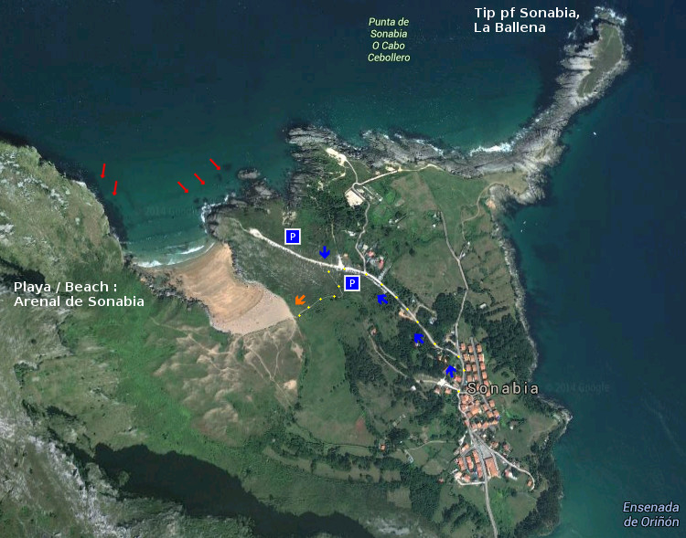
Arenal de Sonabia, playa
![]() El Arenal de Sonabia se encuentra en la localidad de Sonabia, perteneciente al municipio de Liendo. Esta localidad, próxima a Oriñón, concentra en sus cercanías un entorno único que aumenta la belleza de su playa. Siendo su medioambiente su adorno, es la cala y sus olas su contenido para los amantes del surf.
El Arenal de Sonabia se encuentra en la localidad de Sonabia, perteneciente al municipio de Liendo. Esta localidad, próxima a Oriñón, concentra en sus cercanías un entorno único que aumenta la belleza de su playa. Siendo su medioambiente su adorno, es la cala y sus olas su contenido para los amantes del surf.
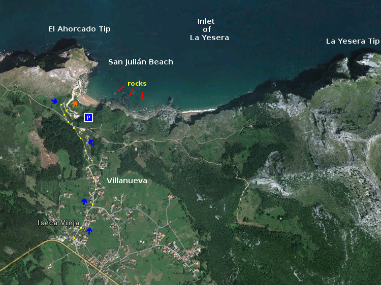
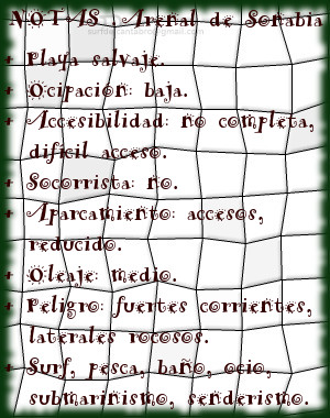
La llegada al arenal se realiza por un escarpado acceso, existiendo varios senderos peatonales. La contemplación de la cala, con 150 metros de longitud y 80 metros de anchura media, destaca el contraste del macizo que la resguarda con las aguas del Mar Cantábrico que la bañan. El Monte Candina protege a la playa y configura la morfología del entorno natural, destacando en la línea de costa y modulando el oleaje que llega hasta Sonabia. La Punta de Yesera, situada a la izquierda, y la Punta Lanzadoiro, a la derecha, delimitan el área norte de la costa de Sonabia ampliando la zona más allá de la playa.
Destaca la arena fina, la calidad de sus aguas y la pendiente que dirige los pasos del caminante hacia el mar. Las olas abren a ambos lados, predominando a izquierdas. Entra el mar con fuerza, la orientación noroeste de la playa permite recoger el oleaje y las corrientes que arriban, por lo que se exige buena condición física. Evitando los laterales rocosos del arenal podremos disfrutar de una de las pocas playas salvajes de Cantabria.

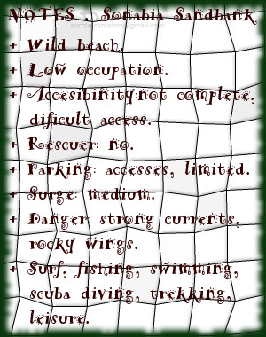
Sandbank of Sonabia, beach
![]() The Sandbank of Sonabia is in the locality of Sonabia, belonging to the municipality of Liendo. This locality, next Oriñón, concentrates in its surroundings an unique environment that increases the beauty of its beach. Being its environment the adornment, it is the cove and the waves; its content for the lovers of surf.
The Sandbank of Sonabia is in the locality of Sonabia, belonging to the municipality of Liendo. This locality, next Oriñón, concentrates in its surroundings an unique environment that increases the beauty of its beach. Being its environment the adornment, it is the cove and the waves; its content for the lovers of surf.
The arrival to the sandbank is realized by an steep access, there are several pedestrian paths. The contemplation of the cove, with 150 meters of length and 80 meters of average width, stands out the contrast of the massif, that protects it, with the waters of the Cantabrian Sea that meets it. The Mount Candina protects the beach and designs the morphology of the natural environment, protruding in the line of coast and modulating the surge that comes up to Sonabia. The Yesera Tip, placed to the left side, and the Lanzadoiro Tip, to the right, delimit the north area of Sonabia’s coast that is extending the zone beyond the beach.
Stands out the thin sand, the quality of its waters and the slope that directs the steps of the wayfarer to the sea. The waves open to both sides, highlighting the left side. It enters the sea strongly, the orientation northwest of the beach allows to gather the surge and the currents that arrive, for what it is required good physical condition. Avoiding the rocky wings of the sandbank, we will be able to enjoy one of few wild beaches of Cantabria.