Castro Urdiales, ciudad
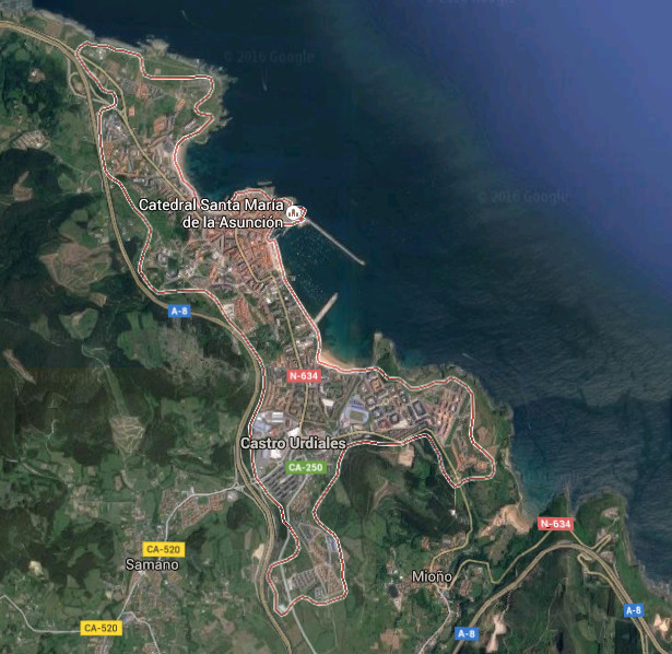
![]() Castro Urdiales es la ciudad más oriental de Cantabria y el municipio con mayor número de kilómetros de litoral. En sus casi 20 kilómetros de costa podemos encontrar pequeños cabos, ensenadas, islas, playas, el Estuario de Oriñón, y numerosas formaciones geológicas de gran belleza. La población de la ciudad, superior a los 30.000 habitantes, la sitúan como noveno municipio cántabro. Dispone de todos los servicios y cuenta con una amplia oferta turística y gastronómica. Destaca el Paseo Marítimo que avanza sobre la mitad de la línea de costa de Castro Uridales, atravesando las playa y el puerto.
Castro Urdiales es la ciudad más oriental de Cantabria y el municipio con mayor número de kilómetros de litoral. En sus casi 20 kilómetros de costa podemos encontrar pequeños cabos, ensenadas, islas, playas, el Estuario de Oriñón, y numerosas formaciones geológicas de gran belleza. La población de la ciudad, superior a los 30.000 habitantes, la sitúan como noveno municipio cántabro. Dispone de todos los servicios y cuenta con una amplia oferta turística y gastronómica. Destaca el Paseo Marítimo que avanza sobre la mitad de la línea de costa de Castro Uridales, atravesando las playa y el puerto.
Es, la llegada a la ciudad, un instante nuevo que va descubriendo las particularidades de la villa. La proximidad del mar y la montaña, la orografía de la zona y su fisonomía describen detalles de su historia y carácter. El transito sereno por el casco viejo descubrirá rincones y momentos congelados en el tiempo. Las cuestas, el adoquinado, los edificios de piedra que albergan locales decorados y cimentados con madera son algunos de los detalles que podemos encontrar.
Castro Urdiales, city
![]() Castro Urdiales is the most oriental city of Cantabria and the municipality with major number of kilometres of littoral. In its almost 20 kilometres of coast, we can find small capes, inlets, islands, beaches, Oriñón’s Estuary, and numerous geological formations of great beauty. The population of the city, superior to 30.000 inhabitants, place it as the nine city of Cantabria. It has all the services and possesses a wide tourist and gastronomic offer. Stands out the Maritime Promenade that advances on the half of the line of Castro Uridales’s coast, crossing the beaches and the port.
Castro Urdiales is the most oriental city of Cantabria and the municipality with major number of kilometres of littoral. In its almost 20 kilometres of coast, we can find small capes, inlets, islands, beaches, Oriñón’s Estuary, and numerous geological formations of great beauty. The population of the city, superior to 30.000 inhabitants, place it as the nine city of Cantabria. It has all the services and possesses a wide tourist and gastronomic offer. Stands out the Maritime Promenade that advances on the half of the line of Castro Uridales’s coast, crossing the beaches and the port.
It is, the arrival to the city, a new instant that is going to discover the particularities of the villa. The proximity of the sea and the mountain, the orography of the zone and its physiognomy describe details of its history and character. The serene traffic for the historic center will show corners and moments frozen in the time. The slopes, the paved one, the buildings of stone that shelter places that are decorated and established with wood are some of the details that we can find.
![]()

 Castro Urdiales, ciudad