Monthly Archives: marzo 2016

EL Sable, playa
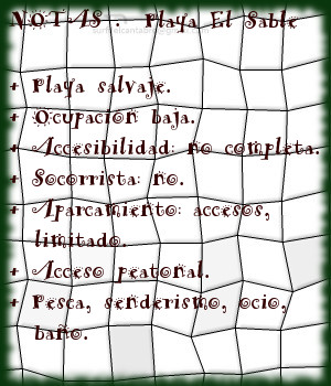
![]() El Sable es una playa situada en la localidad de Prellezo, perteneciente al municipio de Val de San Vicente. Emplazada en el interior de la Ría de Tina Menor, su fisonomía está determinada por el trasiego de las mareas y la configuración del estuario.
El Sable es una playa situada en la localidad de Prellezo, perteneciente al municipio de Val de San Vicente. Emplazada en el interior de la Ría de Tina Menor, su fisonomía está determinada por el trasiego de las mareas y la configuración del estuario.
El Sable, playa de 350 metros de longitud y apenas 10 metros de anchura media, es un pequeño y particular arenal. Localizada entre la desembocadura del Río Nansa y el cierre de la Ría de Tina Menor, disponen de aguas tranquilas y protegidas de mar abierto. Su entorno natural y salvaje se encuentra poblado de bosque atravesado por senderos. El lado derecho de la ría que ocupa la playa es transitable en marea baja hasta su final y al encuentro con el mar. La tranquilidad natural que reina en la zona convierten la estancia en un reconstituyente descanso.
El otoño trae consigo las grandes mareas, removiendo el fondo de arena y arcilla. Tiñe la zona de color beige y deposita nuevos sedimentos que alimentan la diversidad biológica presente. La primavera hace regresar las aves y completa un sistema que puede ser disfrutado desde la playa de El Sable.

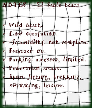
El Sable, beach
![]() El Sable is a beach placed in the locality of Prellezo, belonging to the municipality of Val de San Vicente. Located inside the Estuary of Tina Menor, its physiognomy is determined by the decanting of the tides and the configuration of the tidal river.
El Sable is a beach placed in the locality of Prellezo, belonging to the municipality of Val de San Vicente. Located inside the Estuary of Tina Menor, its physiognomy is determined by the decanting of the tides and the configuration of the tidal river.
El Sable, beach of 350 meters of length and just 10 meters of average width, is an small and particular sandbank. Located between the river mouth of the Nansa River and the closing of Tina Menor, it has calm waters and protected from open sea. Its natural and wild environment is populated of forest crossed by paths. The right side of sea inlet that occupies the beach, it is pasable in low tide until its end and to the meeting with the sea. The natural tranquility that reigns in the zone, turns the stay into a restorative rest.
The autumn brings with it the big tides, removing the bottom of sand and clay. It dyes the zone of beige color and new sediments are despositated that feed the present biological diversity. The spring makes return the birds and completes a system that can be enjoyed from the beach of El Sable.
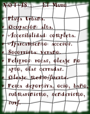
El Muro, lugar
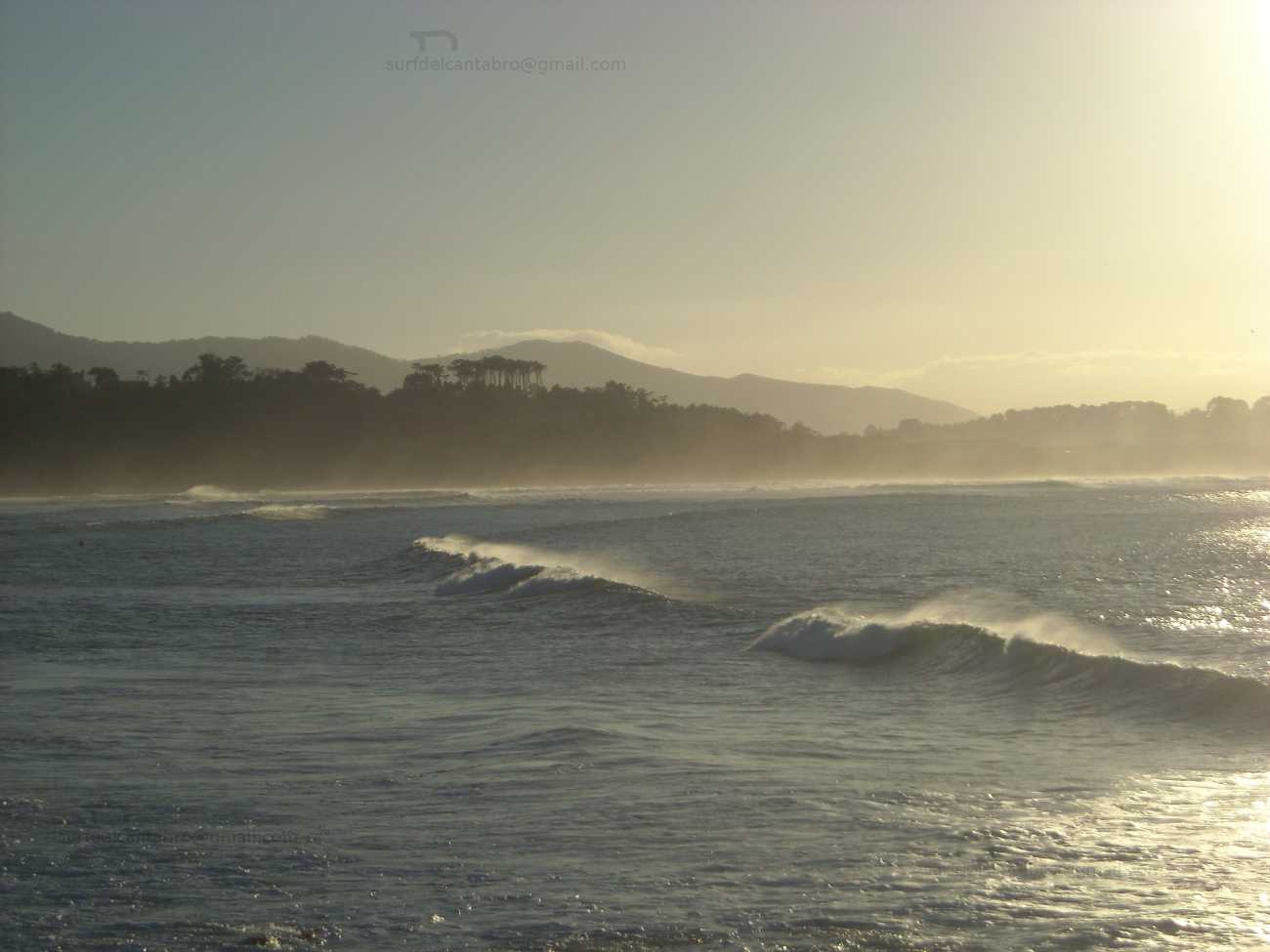
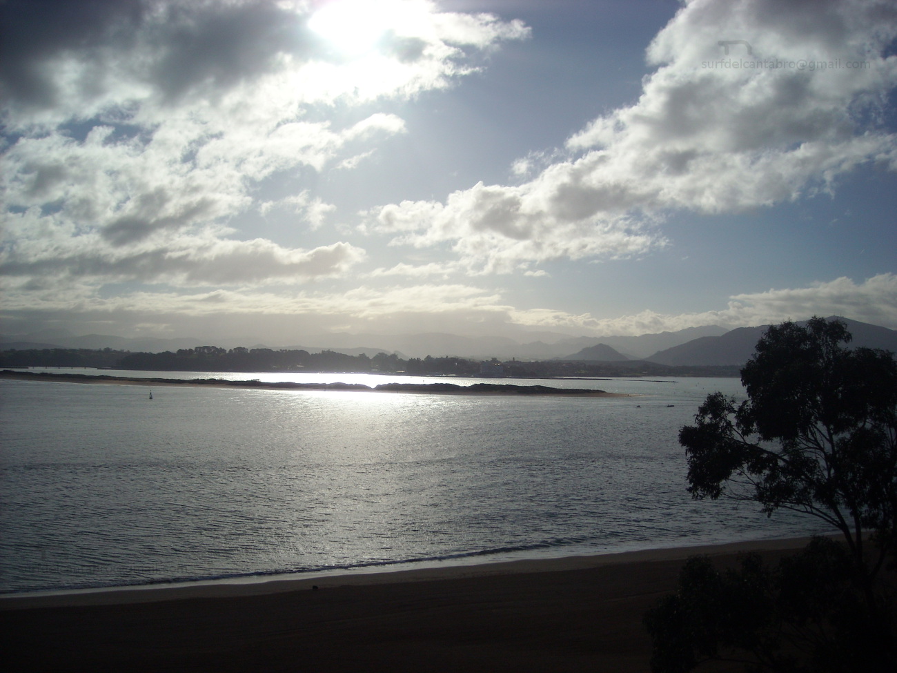
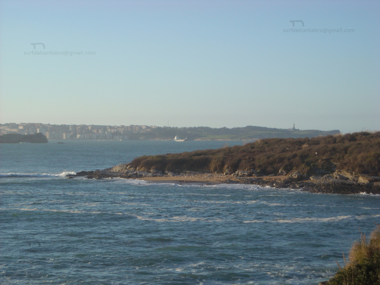
![]() El Muro es una zona que abre un singular circuito para la práctica del surf. Situado en ampliación de la dársena urbana que delimita la ciudad de Santander con la Segunda playa del Sardinero, tiene fácil acceso y cuenta con todos los servicios.
El Muro es una zona que abre un singular circuito para la práctica del surf. Situado en ampliación de la dársena urbana que delimita la ciudad de Santander con la Segunda playa del Sardinero, tiene fácil acceso y cuenta con todos los servicios.
La prolongación de este espacio natural ha introducido su diseño dentro de la Ensenada del Sardinero. Un gran mirador semicircular señala lo puntos más notables de la bahía y actúa como acumulador del oleaje. Llegan las olas hasta este punto para aglutinar masas de agua que abren a izquierdas y pueden alcanzar recorrido medio. Cuando la dirección del oleaje es casi perpendicular a la dársena y ligeramente orientado hacia ella; se dan las mejores condiciones para olas buenas y seguras. El exceso de inclinación provocan que las olas cierren contra el muro; tornando la navegación difícil y peligrosa.
Múltiples opciones aparecerán contemplando el entorno desde EL Muro. Las playas vistas en la distancia, las rocas y promontorios recorridos por un paseo marítimo invitan al caminante a iniciar un pequeño viaje acompañado por el natural, caótico y armónico sonido del mar.
El Muro, place
![]() El Muro is a zone that opens a singular circuit for the practice of surf. Placed in extension of the urban dock that delimits the city of Santander with the Second Sardinero beach , it has easy access and possesses all the services.
El Muro is a zone that opens a singular circuit for the practice of surf. Placed in extension of the urban dock that delimits the city of Santander with the Second Sardinero beach , it has easy access and possesses all the services.
The prolongation of this natural space has introduced its design in the Inlet of the Sardinero. A great semicircular viewing-point indicates the most notable points of the bay and acts as accumulator of the surge. The waves come up to this point to agglutinate water masses that open to left sides and can reach medium tour. When the wave direction is almost perpendicular to the dock and lightly orientated towards it; are given the best conditions for good and sure waves. The excess of inclination provoke that the waves close against the wall; turning the navigation difficult and dangerous.
Multiple options will appear contemplating the environment from El Muro. The beaches are seen in the distance, the rocks and promontories crossed by a promenade invite the wayfarer to initiate an small trip accompanied by the natural, chaotic and harmonic sound of the Sea.

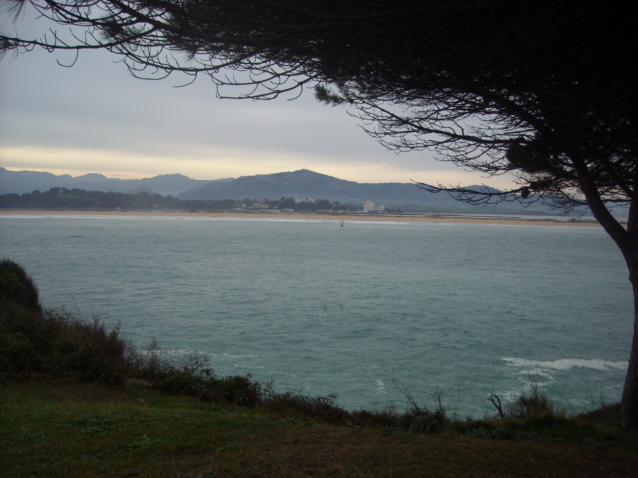
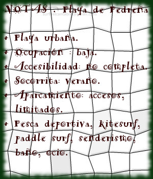
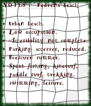
Pedreña, playa
![]() La playa de Pedreña, ubicada en la localidad del mismo nombre, se encuentra en el municipio de Marina de Cudeyo. Emplazada en la orilla sur-oeste de la Bahía de Santander, dispone de un acceso acondicionado que da entrada a varios parajes situados en el sur de la bahía.
La playa de Pedreña, ubicada en la localidad del mismo nombre, se encuentra en el municipio de Marina de Cudeyo. Emplazada en la orilla sur-oeste de la Bahía de Santander, dispone de un acceso acondicionado que da entrada a varios parajes situados en el sur de la bahía.
La playa ocupa 200 metros de longitud y 25 metros de ancho. La marea baja descubre una extensa llanura que puede ser recorrida hasta 1 kilómetro desde la línea de costa. El flanco derecho cuenta con un espigón separa el muelle de la zona y aleja la Ensenada de la Barquería que sirve de canal de navegación para los barcos que cruzan la bahía en dirección a Somo y la Ría de Cubas. El flanco izquierdo habilita mayor extensión hasta finalmente encontrarse con el Pantalán de Calatraba.
La ausencia de olas y el suave trasiego de las mareas convierte a Pedreña en lugar ideal para practicar pesca deportiva, paddle sup y kitesurf. Existe un sendero que recorre esta cara menos conocida de la Bahía de Santander, paralelo al mar y con 2 metros de anchura, finaliza en la localidad vecina Elechas. El paseante podrá disfrutar de distintas vistas panorámicas a lo largo de su recorrido.
Pedreña, beach
![]() The beach of Pedreña, located in the locality of the same name, is in the municipality of Marina de Cudeyo. Situated in the side southwest of the Bay of Santander, it has an equipped access that gives entry to several places placed in the south of the bay.
The beach of Pedreña, located in the locality of the same name, is in the municipality of Marina de Cudeyo. Situated in the side southwest of the Bay of Santander, it has an equipped access that gives entry to several places placed in the south of the bay.
The beach occupies 200 meters of length and 25 meters of width. The low tide discovers an extensive plain that can be crossed up to 1 kilometre from the line of coast. The right flank possesses a breakwater that separates the wharf of the zone and removes it from the Inlet of the Barquería that uses as channel of navigation for the ships that cross the bay towards Somo and the Rivermouth of Cubas. The left flank enables major extension up to finally meeting the Gateway of Calatraba.
The absence of waves and the soft decanting of the tides turn Pedreña in an ideal place to practise sports fishing, paddle sup and kitesurf. There exists a path that crosses this face less known about the Bay of Santander, parallel to the sea and with 2 meters of width, finishes in the neighboring locality of Elechas. The walker will be able to enjoy different panoramic views along the tour.
El Madero, playa
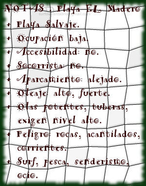
![]() la playa El Madero se ubica en la localidad de Liencres, perteneciente al municipio de Piélagos, en la costa central de Cantabria. Su complicado acceso e irregular arenal la convierten en una playa tranquila donde poder disfrutar del Mar Cantábrico en estado puro.
la playa El Madero se ubica en la localidad de Liencres, perteneciente al municipio de Piélagos, en la costa central de Cantabria. Su complicado acceso e irregular arenal la convierten en una playa tranquila donde poder disfrutar del Mar Cantábrico en estado puro.
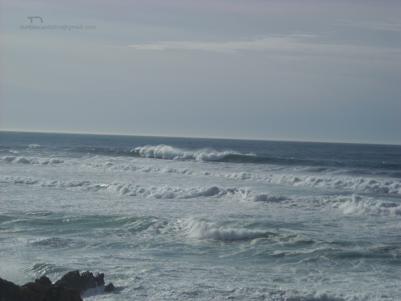
Emplazada en el extremo de la playa de Canallave, sólo es accesible en marea baja. La configuración de la costa, la presencia de rocas y formaciones geológicas constituyen un atractivo para el caminante. Estos tesoros quedan parcialmente cubiertos con la marea alta que impide la entrada y sesga El Madero, camuflando su espacio con las aguas y el oleaje. La presencia de olas, como ocurre en toda la zona, es constante y habitual. Tiene varios picos y olas características. Abren a ambos lados, de medio recorrido y con presencia de tubos. Situando a 200 metros de la orilla, la zona de confort dispone mejor trazado y aleja el peligro de las rocas que habitan en todo el área. La práctica del surf en EL Madero es sólo aconsejable para surfers experimentados que conozcan bien esta singular cala. Además de las rocas, las corrientes tienen una dinámica irregular y cambiante que es reflejado en las olas.
La cima del acantilado que cierra El Madero disfruta del sonido del mar percibido en la distancia y proporciona una visión del entorno que se endulza con el atardecer.
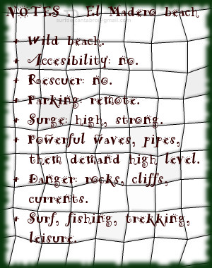
El Madero, beach
![]() The beach El Madero is located in the ocality of Liencres, belonging to the municipality of Piélagos, on the central coast of Cantabria. Its complicated access and irregular sandbank turn it into a calm beach where to be able to enjoy the Cantabrian Sea in pure condition. The presence of waves, as happens in the whole zone, is constant and habitual. It has several beaks and typical waves. Them open to both sides, have medium distance with presence of pipes. Placing to 200 meters of the shore, the zone of comfort arranges better tracing and removes the danger of the rocks that live in all the area.
The beach El Madero is located in the ocality of Liencres, belonging to the municipality of Piélagos, on the central coast of Cantabria. Its complicated access and irregular sandbank turn it into a calm beach where to be able to enjoy the Cantabrian Sea in pure condition. The presence of waves, as happens in the whole zone, is constant and habitual. It has several beaks and typical waves. Them open to both sides, have medium distance with presence of pipes. Placing to 200 meters of the shore, the zone of comfort arranges better tracing and removes the danger of the rocks that live in all the area.
Located in the end of Canallave’s beach, only it is accessible in low tide. The configuration of the coast, the presence of rocks and geological formations constitute an attractive for the wayfarer. These exchequers remain partially covered with the high tide that prevents the entry and cuts El Madero, camouflaging its space with the waters and the surge. The practice of surf in El Madero is only advisable for experienced surfers that know well this singular cove. Besides the rocks, the currents have an irregular and changeable dynamics that is reflected in the waves.
The top of the cliff that closes El Madero enjoys the sound of the sea perceived in the distance and provides a vision of the environment that is sweetened by the late afternoon.