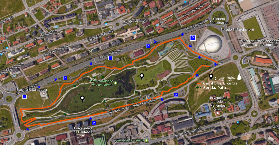
Jardínes de Piquío

Icono Español. Icon Spanish. Jardínes de Piquío Los Jardínes de Piquío es un pequeño y sencillo parque emplazado en la playa de El Sardinero, situado en la ciudad de Santander. Formando parte de un paseo ajardinado que cuenta con zona peatonal y carril bici, es un punto singular del trazado.

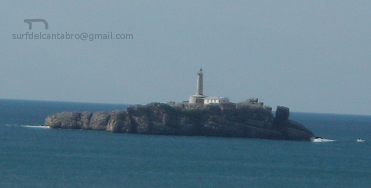
Su base , un acantilado natural conocido originariamente como Roca del Piquillo, divide el arenal en dos playas que se comunican con la bajamar. La construcción de los jardines se remonta al año 1925, cuando la zona fue adecuada para su uso público. Una década después el área es convertida en jardín, siendo objeto de diversas modificaciones a lo largo del siglo XX.

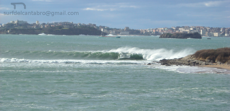
Son su localización y sus vistas panorámicas dos argumentos que nutrirán la visita. Punto medio del extenso recorrido que comienza en la Península de la Magdalena y se prolonga hasta la cara rocosa y acantilada que contiene al Parque de Mataleñas. Principio, parada, o final de un momento que presenta al caminante un extenso y natural anfiteatro donde la naturaleza es la obra a respetar, amar y disfrutar.
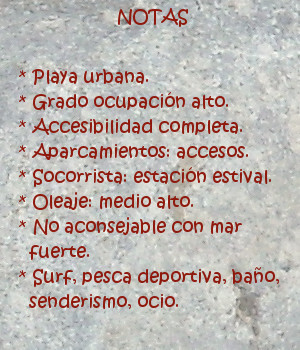
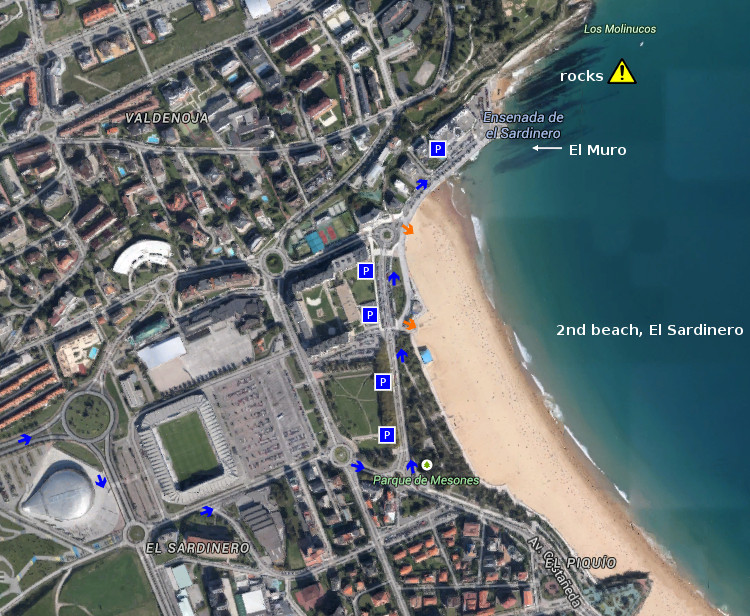
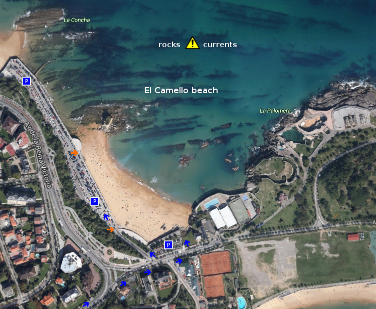
Piquío Gardens

Icono Inglés. Icon English. Piquío Gardens The Gardens of Piquío is an small and simple park located in the beach of El Sardinero, placed in the city of Santander. Forming a part of a landscaped promenade that possesses pedestrian zone and cycle track, it is a singular point of the tracing.

Its base, a natural cliff originally known as Rock of the Piquillo, divides the sandbank in two beaches that are communicated with the low tide. The construction of the gardens goes back at year 1925, when the zone was adapted for its public use. One decade later the area is turned into garden, being an object of diverse modifications along the 20th century.

They are its location and panoramic view two arguments that will nourish the visit. Middle point of the extensive tour that begins in the Peninsula of La Magdalena and extends up to the rocky and steep face that contains to Mataleñas’s Park. Beginning, stop, or end of a moment that presents to the wayfarer an extensive and natural amphitheatre where the nature is the work to be respecting, loving and enjoying.

Icon Local Experience

Share

El Muro, lugar

Icono Español. Icon Spanish. El Muro, lugar El Muro es una zona que abre un singular circuito para la práctica del surf. Situado en ampliación de la dársena urbana que delimita la ciudad de Santander con la Segunda playa del Sardinero, tiene fácil acceso y cuenta con todos los servicios.

La prolongación de este espacio natural ha introducido su diseño dentro de la Ensenada del Sardinero. Un gran mirador semicircular señala lo puntos más notables de la bahía y actúa como acumulador del oleaje. Llegan las olas hasta este punto para aglutinar masas de agua que abren a izquierdas y pueden alcanzar recorrido medio. Cuando la dirección del oleaje es casi perpendicular a la dársena y ligeramente orientado hacia ella; se dan las mejores condiciones para olas buenas y seguras. El exceso de inclinación provocan que las olas cierren contra el muro; tornando la navegación difícil y peligrosa.

Múltiples opciones aparecerán contemplando el entorno desde EL Muro. Las playas vistas en la distancia, las rocas y promontorios recorridos por un paseo marítimo invitan al caminante a iniciar un pequeño viaje acompañado por el natural, caótico y armónico sonido del mar.

Cabecera Cities Place Beaches . El Muro, lugar
El Muro, notas

El Muro, place

Icono Inglés. Icon English. El Muro, place El Muro is a zone that opens a singular circuit for the practice of surf. Placed in extension of the urban dock that delimits the city of Santander with the Second Sardinero beach , it has easy access and possesses all the services.

The prolongation of this natural space has introduced its design in the Inlet of the Sardinero. A great semicircular viewing-point indicates the most notable points of the bay and acts as accumulator of the surge. The waves come up to this point to agglutinate water masses that open to left sides and can reach medium tour. When the wave direction is almost perpendicular to the dock and lightly orientated towards it; are given the best conditions for good and sure waves. The excess of inclination provoke that the waves close against the wall; turning the navigation difficult and dangerous.

Multiple options will appear contemplating the environment from El Muro. The beaches are seen in the distance, the rocks and promontories crossed by a promenade invite the wayfarer to initiate an small trip accompanied by the natural, chaotic and harmonic sound of the Sea.

Cabecera Cities Place Beaches. Pedreña, beach
El Muro, notes

Share

El Camello, playa

Icono Español. Icon Spanish. El Camello, playa El Camello es una pequeña y emblemática playa situada en Santander. Sus reducidas dimensiones, 200 metros de largo y 50 metros de ancho, no reflejan la singularidad del pequeño arenal.

Ubicada entre la Primera playa del Sardinero y la Península de la Magdalena, posee abundantes rocas diseminadas por sus aguas y fondo con pendiente notable. Una de sus formaciones rocosas, con forma de camello, da nombre a la playa. Cuando las condiciones lo permiten, es una zona ideal para practicar submarinismo debido a la riqueza de su arrecife. Destaca también la pesca deportiva y deportes de playa. Los fines de semana y verano se organizan de forma amateur competiciones de palas. La naturaleza de la playa, su fisonomía y limitadas dimensiones descartan la práctica del surf.

Este pequeño rincón de descanso multiplica sus posibilidades a través de sus aguas y la perspectiva que abre de la costa central santanderina. Las playas del Sardinero y Mataleñas a la izquierda, junto con la cara oeste de la Península de la Magdalena, forman una postal que completa la línea del horizonte.

Cabecera Cities Place Beaches . El Camello, playa
El Camello, notas

El Camello, beach

Icono Inglés. Icon English. El Camello, beach El Camello is an small and emblematic beach placed in Santander. Its limited dimensions, 200 meters of length and 50 meters of width, do not reflect the singularity of the small sandbank.

Located between the First beach of the Sardinero and the Peninsula of the Magdalena, it possesses abundant rocks spread by its waters and bottom with notable earring. One of its rocky formations, with form of camel, gives name to the beach. When the conditions allow it, it is an ideal zone to practise scuba diving due to the wealth of its reef. It also the sports fishing and beach sports stand out. The weekends and summer,amateur competitions with ball and raquets on the beach are organized. The nature of the beach, its physiognomy and limited dimensions reject the practice of surf.

This small corner of rest multiplies its possibilities across its waters and the perspective that opens of the central coast of Santander. The beaches of the Sardinero and Mataleñas to the left side, together with the west face of the Peninsula of the Magdalena, form a postcard that completes the line of the horizon.

Cabecera Cities Place Beaches. El Camello, beach
EL Camello, notes

Share

El Sardinero, playa

Icono Español. Icon Spanish. Sardinero playa El Sardinero, ubicado en la ciudad de Santander, es un área grande que se extiende desde la Península de la Magdalena hasta la zona de Mataleñas; próxima al Faro de Cabo Mayor. Sus playas se alojan en un arenal cuya superficie supera las 10 hectáreas. Con una longitud de 1500 metros y una anchura media de 80 metros, el banco de arena queda dividido en dos partes por los Jardines de Píquio. Aparecen así dos playas conocidas como: la Primera playa del Sardinero y la Segunda playa del Sardinero y cuatro zonas diferenciadas, que a la anteriores se unen La Concha y El Muro.

Dentro de esta ensenada que precede a la Bahía de Santander el surf es una de las actividades más importantes. Cuenta con varias zonas y olas diferentes. Los días de mar fuerte las olas entuban y cierran en bloque, no siendo aconsejable su práctica.

Es el Sardinero una playa que convive directamente con el Mar Cántabrico, y sufre los efectos de los temporales que en invierno azotan Cantabria. Por este motivo, hace unos año se reconstruyó el paseo de la parte final de la segunda playa, ampliando y reforzando el muro que allí había. Esta nueva zona espera a las olas que arriban a ella, agolpando y comprimiendo su energía para regenerar las ondas con superficie lisa y medio recorrido. Ola tras ola, ola con ola; forman un circuito que se conoce como El Muro.

comic, mountain
El Sardinero playa, notas

Sardinero, beach

Icono Inglés. Icon English. Sardinero beach El Sardinero, that is located in the city of Santander, it is an extensively area that spreads from the Peninsula of La Magdalena up to Mataleñas’s zone; next the Lighthouse of Cabo Major. Its beaches lodge at a sandbank which surface overcomes 10 hectares. With a length of 1500 meters and width of 80 meters, the bank of sand remains divided in two parts by the Gardens of Píquio. So two beaches appear, known like: the First beach of the Sardinero and the Second beach of the Sardinero and four differentiated zones: La Concha, El Muro and the previous beaches.

Inside this inlet that precedes the Bay of Santander the surf it is one of the most important activities. It possesses several zones and different waves. The days with strong sea the waves create tubes that finish in block, not being advisable its practice.

It is the Sardinero a beach that coexists directly with the Cantabrian Sea, and suffers the effects of the temporary ones that in winter flog Cantabria. For this motive, a few years ago , the promenade of the final part of the second beach was reconstructed, extending and reinforcing the wall that there existed. This new zone receives the arrival of the waves, pushing and compressing its energy to regenerate the waves with smooth surface and medium distance. Wave after wave, wave with wave; them form a circuit that is known as El Muro.

comic, mountain
El Sardinero, notes

Share

El Muro, acceso

Icono Español. Icon Sapnish. El Muro está situado en el extremo norte de la segunda playa de El Sardinero, ubicada en Santander. Esta parte central de la costa cántabra esta protegida por la ensenada que forma Cabo Menor con la Península de la Magdalena. Cuenta con dos accesos directos al arenal y varias zonas de aparcamiento.

El Muro Beach, access

Icono Inglés. Icon English. El Muro is placed in the north end of the second beach of The Sardinero, located in Santander. This central part of the Cantabrian coast is protected by the inlet that forms Cape Menor with the Peninsula of La Magdalena. It possesses two direct accesses to the sandbank and several zones of parking.

Icono español-inglés. Icon Spanish-English. Acceso/Access

El Muro, access

Share

El Muro, localización

Icono Español. Icon Spanish El Muro está situado en el extremo norte de la segunda playa de El Sardinero, en Santander. Es la parte final de una playa urbana que cuenta con todos los servicios. Se muestran a continuación como puntos de partida: Oviedo, Palencia, Santander y Bilbao. Comenzando el viaje por autovía y finalizando el recorrido por la misma carretera nacional en todos los trayectos.

El Muro, localization

Icono Inglés. Icon English El Muro is placed in the north end of the second beach of El Sardinero, in Santander. It is the final part of an urban beach that has all the services. Shown below as starting points: Oviedo , Palencia , Santander and Bilbao . Beginning the trip for motorway and finishing the tour for the same national road in all the options.

Icono Español-Inglés. Icon Spanish-English Localización/Localization

Oviedo, El Muro: LocalizationPalencia, El Muro: LocalizationBilbao, El Muro: LocalizationSantander, El Muro: localization

Share

El Camello, acceso

Icono Español. Icon Spanish. El Camello, acceso La playa de El Camello, situada en la ciudad de Santander, es un pequeño arenal en cuyas aguas alberga un arrecife rocoso de formas variopintas. Tiene dos accesos, acompañados de sendos aparcamientos. Apta para el baño y el ocio, es ideal para practicar submarinismo. Su fondo rocoso y la presencia de corrientes aconsejan realizar el buceo con las debidas precauciones.

El Camello, access

Icono. Icon. El Camello, access The beach of El Camello, placed in the city of Santander, is a small sandbank in whose waters it shelters a rocky reef with multiple and different forms. It has two accesses, accompanied of parkings. Suitable for the swimming and the leisure, it is ideal to practise scuba diving. Its rocky bottom and the presence of currents advise to realize the diving with the due precautions.

Icono español-inglés. Icon Spanish-English. El Camello, acceso/access Acceso/Beach Access

El Camello, access

Share

El Camello, localización

Icono Español. Icon Spanish La playa de El Camello está situada en la ciudad de Santander. Es una pequeña playa con abundante presencia de rocas y peculiar configuración. Sus características la convierten en una zona especial para practicar submarinismo, además del ocio y la pesca.Se puede llegar a esta playa desde Oviedo, Palencia, Santander o Bilbao.

El Camello, Localization

Icono Inglés. Icon English The beach of El Camello is placed in the city of Santander. It is a small beach with abundant presence of rocks and peculiar configuration. Its characteristics turn it into a special zone to practise scuba diving, besides the leisure and the fishing. It is possible to arrive to this beach from Oviedo, Palencia, Santander or Bilbao.

Icono Español-Inglés. Icon Spanish-English Localización/Localization

Oviedo, El_Camello: surf tourPalencia, El Camello: surf tourBilbao, El Camello: surf tourSantander, EL Camello: surf tour

Share

Isla de Mouro

Icono Español. Icon Spanish La Isla de Mouro se encuentra ubicada a la entrada de la Bahía de Santander. Está situada entre La Península de la Magdalena y la Isla de Santa Marina. Ocupa un espacio de 1,7 hectáreas. Formada por rocas que acantilan todo su contorno, en su parte alta es prácticamente llana y cuenta con un faro que en la actualidad está automatizado, llamado Faro de La Isla de Mouro.

Es un lugar ideal para practicar submarinismo por la riqueza de sus fondos. Tiene una flora abundante y variada. Destaca la presencia de una planta, el hinojo marino. Es una especie muy utilizada como condimento gastronómico. Ya en el siglo XVI los buques franceses, ingleses y flamencos en su camino de vuelta desde Santander se aprovisionaban de ella en la Isla de Mouro.

La Isla de Mouro cuenta con una población de aves que nidifican en ella. Las especies de peces que la habitan y visitan es abundante, pues a la riqueza de sus fondos marinos se añade su emplazamiento. A la entrada de la bahía y próxima a su canal. Registra una gran parte de las especies de peces que se pueden encontrar en el Mar Cantábrico.

Destaca como hecho histórico la conquista de la isla por parte de los ingleses a la tropas napoleónicas, durante la Guerra de la Independencia Española (1808 – 1814). Siendo Inglaterra aliada de España.

Mouro Island

Icono Inglés. Icon English The Mouro Island is located at the entrance to the Bay of Santander. It is placed between the Peninsula of la Magdalena and the Santa Marina Island. It occupies an area of 1.7 hectares. Formed by rocks that acantilan all around, in its upper part is virtually flat and with a lighthouse which is now automated, called Lighthouse of Mouro Island.

It is an ideal place to practise diving for the wealth of its funds. It has an abundant and varied flora. It emphasizes the presence of a plant, the marine fennel. It is a species much used as gastronomic seasoning. Already in the XVIth century the French, English and Flemish ships in its way back from Santander were supplied of it in the Island of Mouro.

The Mouro Island has a population of birds that nest in it. The species of fish that inhabit and visit it is abundant, because of the wealth of its seabed and its location. At the entrance to the bay and next to its channel. Registers a large part of the fish species that can be found in Cantabrian Sea.

Stands out as historical fact the conquest of the island by the British to the Napoleonic troops, during the Spanish War of Independence (1808 – 1814). Being England ally of Spain.

Separador. DividerIcono Español-Inglés. Icon Spanish-English
islademouro
islademouro2Icono separador. Icon divider

Icon close Sponsor

Share