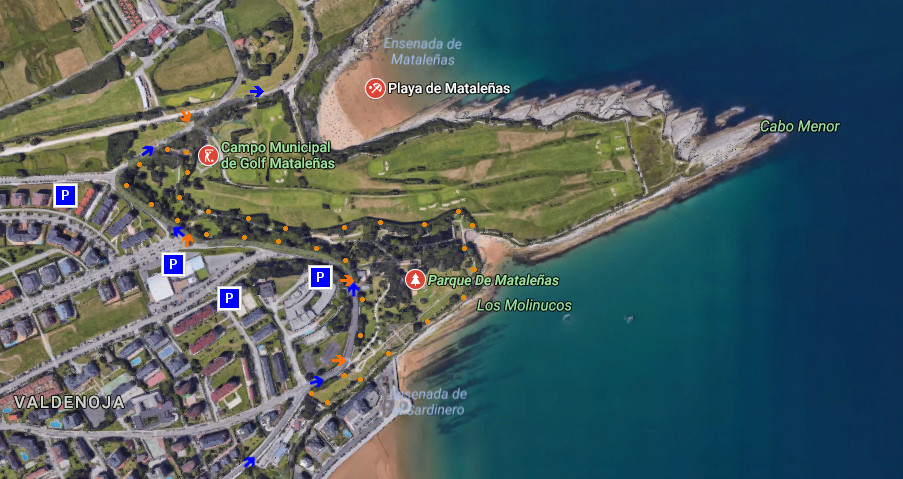
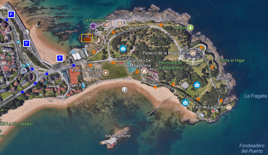
Parque de Mataleñas

Icono Español. Icon Spanish. Mataleñas Park El Parque de Mataleñas, ubicado en Santander, es una amplia zona verde de 18,5 hectáreas de extensión. Su emplazamiento en el extremo noreste de la ciudad constituye un gran mirador desde diversos puntos de su cara sur. Rodeado por carretera urbana, campos de golf y la Ensenada del Sardinero, ofrecen múltiples opciones; tanto dentro como en las proximidades.

Cuatro entradas dan acceso al recinto y se distribuyen a lo largo del trazado exterior que limita con la carretera. Cualquiera de los puntos de entrada proporcionan un recorrido y perspectiva únicos, avanzando a través de los senderos que recorren el conjunto. Verde camino de arboleda acompañado que regala variedad botánica de sencilla belleza.

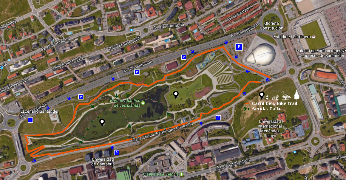
Un gran estanque que termina su trazado en las cercanías de la playa de los Molinucos, donde la imaginación descansa, proporciona al caminante una ideal parada. Edificios singulares que formaban parte de la finca originaria, jardines y campas ocupan parte del territorio. Desde allí la línea imaginaria que supone la entrada a la Bahía de Santander puede ser contemplada desde todos sus puntos.

Icono Español-Inglés. Icon Spanish-English. Mataleñas Park

Separador. DividerIcono separador. Icon divider

Mataleñas Park

Icono Inglés. Icon English. Mataleñas Park Mataleñas Park, located in Santander, is a wide green space of 18,5 hectares of extension. Its emplacement in the North-East extrem of the city constitutes a great viewing-point from diverse items of its south face. Surrounded by urban road, golf courses and the Inlet of El Sardinero, offer multiple options; so much inside like in the proximities.

Four entrances lead to the enclosure and are distributed along the exterior tracing that borders on the road. Any of the entry points provide a unique tour and perspective, advancing across the paths that cross the set. Green way of grove accompanied that gives botanical variety of simple beauty.

A great pond that finishes its tracing in the surroundings of the beach of Los Molinucos, where the imagination rests, provide to the wayfarer an ideal stopped. Singular buildings that were forming a part of the original estate, gardens and meadows occupy part of the territory. From there, the imaginary line that supposes the entry to the Bay of Santander can be contemplated from all its points.

Icon Local Experience

Share

Jardínes de Piquío

Icono Español. Icon Spanish. Jardínes de Piquío Los Jardínes de Piquío es un pequeño y sencillo parque emplazado en la playa de El Sardinero, situado en la ciudad de Santander. Formando parte de un paseo ajardinado que cuenta con zona peatonal y carril bici, es un punto singular del trazado.

Su base , un acantilado natural conocido originariamente como Roca del Piquillo, divide el arenal en dos playas que se comunican con la bajamar. La construcción de los jardines se remonta al año 1925, cuando la zona fue adecuada para su uso público. Una década después el área es convertida en jardín, siendo objeto de diversas modificaciones a lo largo del siglo XX.

Son su localización y sus vistas panorámicas dos argumentos que nutrirán la visita. Punto medio del extenso recorrido que comienza en la Península de la Magdalena y se prolonga hasta la cara rocosa y acantilada que contiene al Parque de Mataleñas. Principio, parada, o final de un momento que presenta al caminante un extenso y natural anfiteatro donde la naturaleza es la obra a respetar, amar y disfrutar.

Piquío Gardens

Icono Inglés. Icon English. Piquío Gardens The Gardens of Piquío is an small and simple park located in the beach of El Sardinero, placed in the city of Santander. Forming a part of a landscaped promenade that possesses pedestrian zone and cycle track, it is a singular point of the tracing.

Its base, a natural cliff originally known as Rock of the Piquillo, divides the sandbank in two beaches that are communicated with the low tide. The construction of the gardens goes back at year 1925, when the zone was adapted for its public use. One decade later the area is turned into garden, being an object of diverse modifications along the 20th century.

They are its location and panoramic view two arguments that will nourish the visit. Middle point of the extensive tour that begins in the Peninsula of La Magdalena and extends up to the rocky and steep face that contains to Mataleñas’s Park. Beginning, stop, or end of a moment that presents to the wayfarer an extensive and natural amphitheatre where the nature is the work to be respecting, loving and enjoying.

Icon Local Experience

Share

Península de la Magdalena

Icono Español. Icon Spanish. La Magdalena, peninsula La Península de la Magdalena, emplazada en Santander, es una punta insular unida por un istmo de tierra a la cara norte de la Bahía de Santander. Su localización geográfica la convierte en puerta de entrada a la bahía. La parte Noreste esta en contacto con el Mar Cantábrico, mientras que su parte Sur es bañada por las aguas interiores de la bahía.

La entrada, libre y gratuita, al recinto se realiza por la puerta principal; a través de un acceso controlado. Su horario de apertura es de 8 de la mañana a 10 de la noche, permitiendo una amplia agenda para recorrer el parque, visitar sus puntos de interés o disfrutar de la naturaleza. Después, una carretera asfaltada que guía el transito nos permitirá conocer su extensión y llegar a todas las zonas.

La campa de entrada, punto de celebración de conciertos y competiciones deportivas, permite alcanzar las playas de la Magdalena, Vikinis y la playa de la Reina. EL Embarcadero Real y el Faro de la Cerda siguen en el camino de ascenso hasta llegar al Palacio de la Magdalena. El sendero emprende el regreso, volviendo finalmente al comienzo. Antes, podemos encontrar un museo al aire libre dedicado al ‘Hombre y la Mar’, homenaje a un navegante cántabro. Un pequeño parque marino y de aves junto con varios monumentos completan los atributos de esta especial ubicación.

Peninsula of the Magdalena

Icono Inglés. Icon English. La Magdalena, peninsula The Peninsula of the Magdalena, located in Santander, is an insular top joined by an isthmus of land to the north face of the Bay of Santander. Its geographical location turns it into door of entry to the bay. The north-eastern part is in touch with the Cantabrian Sea, whereas its southern part is bathed by the interior waters of the bay.

The entry, free, to the enclosure is realized by the principal door; across a controlled access. Its time schedule is from 8 of the morning to 10 of the night, allowing a wide agenda to cross the park, to visit its points of interest or to enjoy the nature. Later, a paved road that guides the transit will allow us to know its extension and to come to all the zones.

The meadow of entry, point of celebration of concerts and sports competitions, allows to reach the beaches of the Magdalena, Vikinis and the beach of La Reina. The Royal Pier and the Lighthouse of La Cerda continue in the way of ascent up to coming to the Palace of La Magdalena. The path undertakes the return, coming back finally to the beginning. Before, we can find a museum outdoors dedicated to the ‘ Man and the Sea ‘, honoring to a Cantabrian navigator. An small marine and birds park, together with several monuments complete the attributes of this special location.

Icon Local Experience

Share

Plaza del Ayuntamiento

Icono Español. Icon Spanish. parque atlantico de las llamas La Plaza del ayuntamiento, ubicada en Santander y contigua a la casa consistorial, es una pequeña zona que ocupa media hectárea de superficie situada en el centro de la ciudad. La cercanía del Cabildo de Arriba, el barrio más antiguo de Santander, y la configuración urbanística la dotan de forma propia a modo de triángulo. Al Sur y Este, sendas carreteras que vertebran el centro de la ciudad, acotan la plaza. Debido a la distribución de la villa que se orienta hacia la bahía y la situación de este foro, lo convierten en un punto neurálgico del trasporte urbano.

La singular explanada dispone de zonas verdes, arbolado, bancos para el reposo y parada de autobús. Pasajeros a ambos lados de la carretera, personas que pueblan o recorren la plazuela acumulan un transito de personas plasmado a extremos, desde una particular soledad hasta el bullicio de la hora punta. Superficie existente y obligada por el espacio disponible de sencillo y singular arte que da significado a la estancia cuando se contempla a través de 360 grados partiendo de ese punto y posando la vista en los edificios que la rodean.

City hall Square

Icono Inglés. Icon English. Atlantic Park of las llamas The City hall Square , located in Santander and contiguous to the town hall, is an small zone that occupies half hectare of surface placed in the downtown. The nearness of the Council of Arriba, the most ancient neighborhood of Santander, and urban configuration provide it with own form like a triangle. In the South and East part, two roads that structure the downtown, limit the square. Due to the distribution of the villa that is orientated towards the bay and the situation of this forum, turn it into a neuralgic point of the urban transport.

The singular esplanade has green spaces, woodland, banks for the rest and stop of bus. Passengers on both sides of the road, persons who populate or cross the plazuela accumulate a persons’ traffic formed to ends, from a particular loneliness up to the hustle of the rush hour. Surface existing and forced by the available space of simple and singular art that gives meaning to the stay when it is contemplated across 360 degrees departing from this point and putting the sight in the buildings that surround it.

Icon Local Experience

Share

Parque Atlántico de las Llamas

Icono Español. Icon Spanish. parque atlantico de las llamas El Parque Atlántico de las llamas, situado en la ciudad de Santander, es una amplia zona verde recuperada cuya extensión alcanza las 11 hectáreas. Emplazado en las proximidades de la costa Este de la ciudad, junto a las playas del Sardinero, se prolonga hasta el barrio de La Albericia.

El parque, ubicado en la vaguada de las Llamas, se encuentra entre la Avenida de los Castros y el barrio de Valdenoja. Su estado natural originario recibía una de las dos rías de la ciudad y estaba flanqueado por dunas y laderas. La reconstrucción ha recuperado parte de aquel paisaje, disponiendo un terreno pantanoso que vertebra el área, acompañado de carril bici, zonas de ocio y descanso.

La vegetación autóctona presente cuenta con abedules, robledales, alisos, hayas, abedules y tejos entre otras especies. Aves insectívoras y limícolas, como el martín pescador o la garza real son algunos ejemplos de animales propios de este bosque atlántico. La presencia permanente de agua posibilita la existencia de anfibios como sapos o tritones. Estos nombre ejemplares son una parte de la peculiar orquesta que se ha conseguido reproducir, a imitación de antaño.

Atlantic Park of Las Llamas

Icono Inglés. Icon English. Atlantic Park of las llamas The Atlantic Park of Las Llamas, placed in the city of Santander, is a wide recovered green space which extension reaches 11 hectares. Located in the proximities of the East coast of the city, close to the beaches of the Sardinero, it extends up to the neighborhood of La Albericia.

The park located in the valley of Las Llamas, is between the Avenue of the Castros and neighborhood of Valdenoja. Its natural original condition was receiving one of the two estuaries of the city and it was flanked by dunes and hillsides. The reconstruction has recovered part of that landscape, arranging a swampy area that is the esential structure of the area, accompanied of bikeway, zones of leisure and rest.

The autochthonous vegetation there possesses birches, oakwoods, alder-trees, beeches, birches and yews between other species. Insectivorous birds and waders, as the martín fisherman or the royal heron are some examples of the animals of this Atlantic forest. The permanent presence of water makes the existence of amphibians possible as toads or newts. These examples of names are a part of the peculiar orchestra that has managed to reproduce, to imitation of long ago.

Icon Local Experience

Share

Potes, villa y capital de Liébana

Icono Español. Icon Spanish. Loredo, villa village Potes es una localidad situada en la región occidental de Cantabria. Emplazada en la comarca de Liébana y siendo su capital, se encuentra a 291 metros de altitud, en el corazón del Parque Nacional de Picos de Europa.

La localización única de la villa la convierte en un punto de encuentro de cuatro valles. Recibe la desembocadura del Río Quiviesa, que sirve de afluente al Río Deva el cual nace en el Macizo Cántabrico. La orografía montañosa que perfila su contorno delimita la comarca y configura un entorno natural excepcional. La existencia de valles en su interior representa diferencias de altitud y crea un microclima mediterráneo en el fondo de este gran valle que se torna atlántico a medida que ascendemos hasta los picos que alcanzan los 2000 metros.

Habitada desde tiempos prehistóricos, fue repoblada en el siglo VIII y IX durante La Reconquista. En aquella época recibió numerosa población que contribuyó a enriquecer la vida y cultura de Liébana a lo largo de la Edad Media. Destacan la Torre del Infantado, Torre del Orejón de la Lama, la Iglesia de San Vicente y el Puente de San Cayetano cómo muestras arquitectónicas de una época. La configuración de Potes, sus barrios, calles y plazas trasmiten el paso del tiempo y la historia vivida. Los barrios de la Solana y el Sol concentran numerosas edificaciones que hacen del casco histórico Bien de Interés Cultural.

Es su clima característico el que posibilita la existencia del cultivo de la vid que sirve para elaborar el orujo de Potes. Abundan las encinas y alcornoques, característicos del bosque mediterráneo, entremezclados con especies propias del bosque atlántico como el hayedo y el roble. Otras especies como tejos, alisos, acebos, avellanos, chopos … amplían la diversidad y embellecen su naturaleza.

Potes, village and capital of Liébana

Icono Inglés. Icon English. Loredo, villa, village Potes it is a locality placed in the western region of Cantabria. Located in the region of Liébana and being its capital, it is to 291 meters of altitude, in the heart of the National Park of Picos de Europa.

The unique location of the villa turns it into a point of meeting of four valleys. It receives the river mouth of the river Quiviesa, tributary to the Rio Deva which is born in the Cantabrian Range. The mountainous orography that outlines his contour delimits the region and forms an excepcional natural environment. The existence of valleys inside it represents differences of altitude and creates a Mediterranean microclimate at the back of this great valley that becomes Atlantic as we ascend up to the beaks that reach 2000 meters.

Populated from prehistoric times, it was repopulated in the 8th century and the IXth during The Reconquest. In that epoch Potes received numerous population who helped to enrich the life and culture of Liébana along the Middle Ages. Emphasize the Tower of the Infantado, Tower of Orejón de la Lama, San Vicente’s Church and San Cayetano’s Bridge as architectural examples of an epoch. The configuration of Potes, its neighborhoods, streets and squares transfer the passage of time and the lived history. The neighborhoods of the Solana and the Sol concentrate numerous buildings that do of the historical center an Heritage of Cultural Interest.

It is its typical climate the one that makes possible the existence of the culture of the grapevine that serves to elaborate the grape marc of Potes. The holm oaks and cork oaks abound, typical of the Mediterranean forest, intermingled with own species of the Atlantic forest as the hayedo and the oak. Other species like yews, alder-trees, hollies, hazels, black poplars … extend the diversity and embellish its nature.

Loredo, villa village. Icon text divider

Potes localización. Localization

Icono español-inglés. Icon Spanish-English. Loredo, villa, village. Map Potes, village

Mapa Potes

Icono español-inglés. Icon Spanish-English. Loredo, villa, village. Map Liébana, natural area

Mapa Entorno Potes

Loredo, villa, village. icon close cities

Share

Circuito de Parayas

Icono Español. Icon Spanish. Circuito de Parayas El Circuito de Parayas, también conocido como Circuito del Aeropuerto, es una senda ciclable y peatonal que rodea el Aeropuerto de Santander. La longitud de la vía, con 6,83 km, contiene este gran área. Recorriendo las afueras de las localidades de Maliaño y Santander, atraviesa el Polígono de Raos y su Puerto Deportivo, La Punta de Parayas, los exteriores del aeropuerto. Finaliza o comienza, pues el circuito es bidirecional, con una parte de la senda que transcurre paralela a la autovía que da acceso a la capital cántabra.

La travesía, abierta sobre un carril de dos metros de anchura, próxima a carretera ocupa el 70% del trazado. La parte interior de este, dispone de un entorno natural singular que forma parte del extremo oeste de la Bahía de Santander. Contiguo al mirador de la bahía, se encuentra una zona de bosque y humedal ajardinada. La comunicación entre ambas zonas se realiza a través de un paso subterráneo, habilitado allí donde el aeropuerto y la bahía se reúnen. Este paso está operativo desde las 10:00 A.M hasta las 20:00 P.M, permaneciendo cerrado fuera del horario. El camino puede ser completado entre 30 y 50 minutos, ya sea en bicicleta o a pie. Tiempo determinado por la voluntad del caminante, relajado o intenso, pero siempre acompañado por la libertad de un espacio natural y abierto.

Parayas circuit

Icono Inglés. Icon English. Circuit of Parayas The Circuit of Parayas, also known as Airport`s Circuit, is a cyclable and pedestrian path that surrounds the Airport of Santander. The length of the route, with 6,83 km, contains this great area. Crossing the soutskirts of the localities of Maliaño and Santander, it traverses the Polygon of Raos and its yachting port, The Tip of Parayas, the exteriors of the airport. It finishes or begins, since the circuit is bidirecional, with a part of the way that passes parallel to the highway that leads to the Cantabrian capital.

The voyage, opened on a rail of two meters of width, next to road occupies 70 % of the tracing. The interior part of this, has a natural singular environment that forms a part of the West extreme of the Bay of Santander. Contiguous to the viewing-point of the bay, one finds a zone of forest and wetland landscaped. The communication between both zones is realized across an underground, qualified there where the airport and the bay are met. This passage is operative from 10:00 A.M up to 22:00 P.M, remaining closed out of the schedule. The way can be completed between 30 and 50 minutes, whether to walk or bicycle. Time determined by the will of the wayfarer, relaxed or intense, but always accompanied by the freedom of a natural and opened space.

Separador. DividerIcono Español-Inglés. Icon Spanish-EnglishParayas CircuitIcono separador. Icon divider

Icon Local Experience

Share

Mercado de la Esperanza

Icono Español. Icon Spanish Situada detrás del ayuntamiento, con presencia habitual de viandantes y vehículos que transitan su contorno acotado por carreteras hábiles, está el Mercado de la Esperanza. Al cobijo del singular edifico de piedra y metal que contiene los comercios habita una pequeña plaza ocupada por las mañanas con puestos ambulantes, prolongación del mercado. Varios días a la semana las calles aledañas son invadidas por otros puestos de flores, plantas, cuadros y menaje del hogar.

Un paso tras otro conducían a Pedro hacia la plaza. Acompañado por su madre, la ciudad no parecía tan grande desde sus 7 años. Una amalgama de personas, productos y tenderetes ocultaba las baldosas de la calle Los Escalantes. El bullicio matutino cruzaba conversaciones privadas con proveedores y profesionales que anunciaban su producto entre chascarrillos, sonrisas y la mirada curiosa de un niño. Marta agarro a su hijo con fuerza y le dijo «no te separes de mí y no toques nada». Caminando a paso ligero se dirigieron a la entrada.

El Sol que iluminaba la calle, lucia el edificio de piedra y la cristalera de la segunda planta disparaba fugaces reflejos del astro. La entrada a la plaza sustituyó la luz natural por la luz filtrante de los focos del interior. La atmósfera estaba teñida de colores y formas sombreadas que ambientaban el lugar. Las pescaderas ordenaban el producto, limpiaban los peces e iban atendiendo a los clientes. Cabrachos rojizos y de peculiar aspecto completaban el muestrario de sardinas, salmonetes y bocartes que tenia el puesto número dos a la entrada del recinto. Marta cruzaba con andar sereno hacia su puesto de confianza, ojeando la mercancía. Los ojos del niño alumbraban allá donde la madre mirase…

Hope Market

Icono Inglés. Icon English Placed behind the town hall, with habitual presence of pedestrian and vehicles that circulate its contour annotated by skilful roads, is the Market of the Hope. To the shelter of the singular building of stone and metal that contains the stalls there is an small square occupied in the mornings with ambulant shops, prolongation of the market. Several days a week the bordering streets are invaded by other flower stands, plants, pictures and furniture of the home.

One step after other were leading Pedro towards the marketplace. Accompanied by his mother, the city did not seem to be so big from his 7 years. An amalgam of persons, products and stands was concealing the tiles of the street Los Escalantes. The morning hustle was crossing private conversations with suppliers and professionals who were announcing the product between funny stories, smiles and the curious look of a child. Marta strongly caught his son and said to him «you do not separate of me and do not touch anything «. Walking quickly they went at the entry.

The Sun that was illuminating the street, shined the building of stone and the windows of the second floor was shooting fleeting reflections of the star. The entry to the square replaced the natural light with the filtering light of the lightbulbs that were inside. The atmosphere was dyed of colors and shaded forms that were setting the place. The fishmongers were arranging the product, cleaning the fish and attending to the clients. Reddish scorpion fishes with peculiar aspect were completing the sample of sardines, red mullets and anchovies that had the stand number two at the entry of the enclosure. Marta was crossing, serenely towards his stall of confidence, and seeing the goods. The eyes of the child were lighting there where the mother was looking…

Icon Local Experience

Share