Tag Archives: Santander Bay

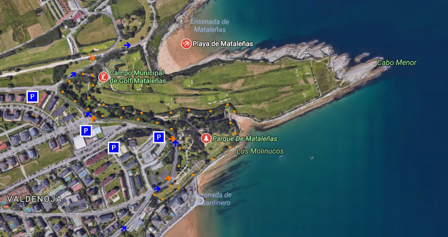
Parque de Mataleñas
![]() El Parque de Mataleñas, ubicado en Santander, es una amplia zona verde de 18,5 hectáreas de extensión. Su emplazamiento en el extremo noreste de la ciudad constituye un gran mirador desde diversos puntos de su cara sur. Rodeado por carretera urbana, campos de golf y la Ensenada del Sardinero, ofrecen múltiples opciones; tanto dentro como en las proximidades.
El Parque de Mataleñas, ubicado en Santander, es una amplia zona verde de 18,5 hectáreas de extensión. Su emplazamiento en el extremo noreste de la ciudad constituye un gran mirador desde diversos puntos de su cara sur. Rodeado por carretera urbana, campos de golf y la Ensenada del Sardinero, ofrecen múltiples opciones; tanto dentro como en las proximidades.
Cuatro entradas dan acceso al recinto y se distribuyen a lo largo del trazado exterior que limita con la carretera. Cualquiera de los puntos de entrada proporcionan un recorrido y perspectiva únicos, avanzando a través de los senderos que recorren el conjunto. Verde camino de arboleda acompañado que regala variedad botánica de sencilla belleza.
Un gran estanque que termina su trazado en las cercanías de la playa de los Molinucos, donde la imaginación descansa, proporciona al caminante una ideal parada. Edificios singulares que formaban parte de la finca originaria, jardines y campas ocupan parte del territorio. Desde allí la línea imaginaria que supone la entrada a la Bahía de Santander puede ser contemplada desde todos sus puntos.
![]()
![]()
![]()
Mataleñas Park
![]() Mataleñas Park, located in Santander, is a wide green space of 18,5 hectares of extension. Its emplacement in the North-East extrem of the city constitutes a great viewing-point from diverse items of its south face. Surrounded by urban road, golf courses and the Inlet of El Sardinero, offer multiple options; so much inside like in the proximities.
Mataleñas Park, located in Santander, is a wide green space of 18,5 hectares of extension. Its emplacement in the North-East extrem of the city constitutes a great viewing-point from diverse items of its south face. Surrounded by urban road, golf courses and the Inlet of El Sardinero, offer multiple options; so much inside like in the proximities.
Four entrances lead to the enclosure and are distributed along the exterior tracing that borders on the road. Any of the entry points provide a unique tour and perspective, advancing across the paths that cross the set. Green way of grove accompanied that gives botanical variety of simple beauty.
A great pond that finishes its tracing in the surroundings of the beach of Los Molinucos, where the imagination rests, provide to the wayfarer an ideal stopped. Singular buildings that were forming a part of the original estate, gardens and meadows occupy part of the territory. From there, the imaginary line that supposes the entry to the Bay of Santander can be contemplated from all its points.
![]()
Somo, El Puntal. Ruta de senderismo
![]() Somo es una localidad costera cántabra situada en la orilla sur de la Bahía de Santander. Emplazada en la costa central de Cantabria, dispone y tiene acceso a un extenso arenal de más de 7 kilómetros de longitud. Esta zona única contiene varias playas establecidas en mar abierto que reciben el oleaje del Mar Cantábrico.
Somo es una localidad costera cántabra situada en la orilla sur de la Bahía de Santander. Emplazada en la costa central de Cantabria, dispone y tiene acceso a un extenso arenal de más de 7 kilómetros de longitud. Esta zona única contiene varias playas establecidas en mar abierto que reciben el oleaje del Mar Cantábrico.
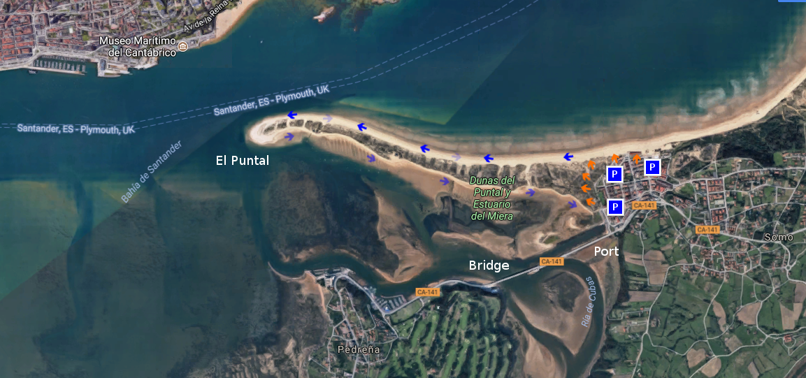
La playa situada en el extremo occidental es conocida como El Puntal, una lengua de arena con tres kilómetros de longitud. Bañada por el mar en sus dos vertientes, dispone de un recinto dunar; existente a lo ancho de su área. Su ruta de ida y vuelta requiere mesura y una condición física mínima. El camino se realiza por arena, o a través de pequeños senderos irregulares abiertos entre las dunas.
La ruta comienza en Somo. Desde cualquier localización podremos acceder a la playa y comenzar la travesía. Un punto de partida adecuado es el Embarcadero de Somo, cuenta con un amplio aparcamiento y varios accesos a las dunas. El camino empieza ofreciendo una vista panorámica de la bahía. La ciudad de Santander, al fondo, completa el mosaico. Cada paso irá acompañado por el sonido del oleaje. El color azulado y oscurecido del agua descubre una línea imaginaria que recorrer la orilla, invitando a continuar y descubrir su final. La arena húmeda que aparece en bajamar facilita la ruta que puede ser alternada sobre arena seca, acorde a nuestra condición física. A mitad de camino, sobre la silueta del banco de arena, aparece una curva interior seguida de otra exterior. En este punto, va asomando la ciudad, descubriendo su profundidad conforme avanzamos.
Al final del recorrido, un amplio espacio presenta singulares vistas de la Bahía de Santander. El atardecer lucirá un plano general enmarcado por el cielo y el entorno. El camino de regreso puede ser realizado volviendo sobre nuestros pasos o eligiendo el lados sur de El Puntal. Desde allí es posible disfrutar de otros espacios y localidades que comparten la bahía, finalizando con el Puente de Somo, la Ría de Cubas y el Embarcadero.
![]()
![]()
![]()
Somo, El Puntal. Trekking route
![]() Somo is a coastal locality Cantabrian placed in the south shore of the Bay of Santander. Located on the central coast of Cantabria, it arranges and has access to an extensive sandbank of more than 7 kilometres of length. This unique zone contains several beaches established on the open sea that receive the surge of the Cantabrian Sea.
Somo is a coastal locality Cantabrian placed in the south shore of the Bay of Santander. Located on the central coast of Cantabria, it arranges and has access to an extensive sandbank of more than 7 kilometres of length. This unique zone contains several beaches established on the open sea that receive the surge of the Cantabrian Sea.
The beach placed in the western end is known as El Puntal, a language of sand with three kilometres of length. Sorrounded by the sea in its two slopes, it has a dune enclosure widthways its existing area. Its round trip route needs moderation and a minimum physical condition. The way is realized by sand, or across small irregular paths opened between the dunes.
The route begins in Somo. From any location we will be able to accede to the beach and to begin the voyage. An ideal point of is The Port of Somo, relies a wide parking and several accesses to the dunes. The way starts by offering a panoramic sight of the bay. The city of Santander, to the bottom, completes the mosaic. Every step will be accompanied by the sound of the surge. The color bluish and got dark of the water discovers an imaginary line that run cross the shore, inviting to continue and discover its end. The humid sand that appears in low tide facilitates the route that can be alternated over dry item, as allow our physical condition. To midway, on the silhouette of the sandbank, there appears an interior curve followed by exterior other one. In this point, the city is going appear, discovering its depth as we advance.
At the end of the tour, a wide space presents a singular views of the Bay of Santander. The sunset will illuminate an outlook framed by the sky and the environment. The return way can be realized over our steps or choosing the south side of El Puntal. From there it is possible to enjoy other spaces and localities that share the bay, finishing with the Bridge of Somo, the Estuary of Cubas and the Port.
![]()
Península de la Magdalena
![]() La Península de la Magdalena, emplazada en Santander, es una punta insular unida por un istmo de tierra a la cara norte de la Bahía de Santander. Su localización geográfica la convierte en puerta de entrada a la bahía. La parte Noreste esta en contacto con el Mar Cantábrico, mientras que su parte Sur es bañada por las aguas interiores de la bahía.
La Península de la Magdalena, emplazada en Santander, es una punta insular unida por un istmo de tierra a la cara norte de la Bahía de Santander. Su localización geográfica la convierte en puerta de entrada a la bahía. La parte Noreste esta en contacto con el Mar Cantábrico, mientras que su parte Sur es bañada por las aguas interiores de la bahía.
La entrada, libre y gratuita, al recinto se realiza por la puerta principal; a través de un acceso controlado. Su horario de apertura es de 8 de la mañana a 10 de la noche, permitiendo una amplia agenda para recorrer el parque, visitar sus puntos de interés o disfrutar de la naturaleza. Después, una carretera asfaltada que guía el transito nos permitirá conocer su extensión y llegar a todas las zonas.
La campa de entrada, punto de celebración de conciertos y competiciones deportivas, permite alcanzar las playas de la Magdalena, Vikinis y la playa de la Reina. EL Embarcadero Real y el Faro de la Cerda siguen en el camino de ascenso hasta llegar al Palacio de la Magdalena. El sendero emprende el regreso, volviendo finalmente al comienzo. Antes, podemos encontrar un museo al aire libre dedicado al ‘Hombre y la Mar’, homenaje a un navegante cántabro. Un pequeño parque marino y de aves junto con varios monumentos completan los atributos de esta especial ubicación.
Peninsula of the Magdalena
![]() The Peninsula of the Magdalena, located in Santander, is an insular top joined by an isthmus of land to the north face of the Bay of Santander. Its geographical location turns it into door of entry to the bay. The north-eastern part is in touch with the Cantabrian Sea, whereas its southern part is bathed by the interior waters of the bay.
The Peninsula of the Magdalena, located in Santander, is an insular top joined by an isthmus of land to the north face of the Bay of Santander. Its geographical location turns it into door of entry to the bay. The north-eastern part is in touch with the Cantabrian Sea, whereas its southern part is bathed by the interior waters of the bay.
The entry, free, to the enclosure is realized by the principal door; across a controlled access. Its time schedule is from 8 of the morning to 10 of the night, allowing a wide agenda to cross the park, to visit its points of interest or to enjoy the nature. Later, a paved road that guides the transit will allow us to know its extension and to come to all the zones.
The meadow of entry, point of celebration of concerts and sports competitions, allows to reach the beaches of the Magdalena, Vikinis and the beach of La Reina. The Royal Pier and the Lighthouse of La Cerda continue in the way of ascent up to coming to the Palace of La Magdalena. The path undertakes the return, coming back finally to the beginning. Before, we can find a museum outdoors dedicated to the ‘ Man and the Sea ‘, honoring to a Cantabrian navigator. An small marine and birds park, together with several monuments complete the attributes of this special location.
![]()
Circuito de Parayas
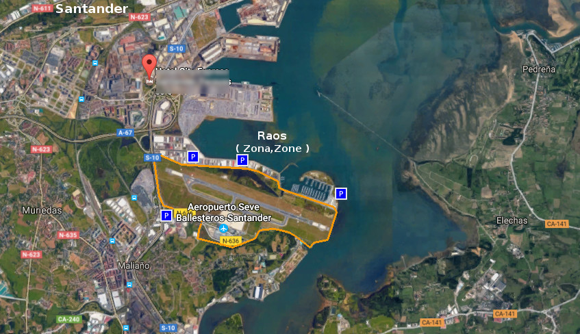
![]() El Circuito de Parayas, también conocido como Circuito del Aeropuerto, es una senda ciclable y peatonal que rodea el Aeropuerto de Santander. La longitud de la vía, con 6,83 km, contiene este gran área. Recorriendo las afueras de las localidades de Maliaño y Santander, atraviesa el Polígono de Raos y su Puerto Deportivo, La Punta de Parayas, los exteriores del aeropuerto. Finaliza o comienza, pues el circuito es bidirecional, con una parte de la senda que transcurre paralela a la autovía que da acceso a la capital cántabra.
El Circuito de Parayas, también conocido como Circuito del Aeropuerto, es una senda ciclable y peatonal que rodea el Aeropuerto de Santander. La longitud de la vía, con 6,83 km, contiene este gran área. Recorriendo las afueras de las localidades de Maliaño y Santander, atraviesa el Polígono de Raos y su Puerto Deportivo, La Punta de Parayas, los exteriores del aeropuerto. Finaliza o comienza, pues el circuito es bidirecional, con una parte de la senda que transcurre paralela a la autovía que da acceso a la capital cántabra.
La travesía, abierta sobre un carril de dos metros de anchura, próxima a carretera ocupa el 70% del trazado. La parte interior de este, dispone de un entorno natural singular que forma parte del extremo oeste de la Bahía de Santander. Contiguo al mirador de la bahía, se encuentra una zona de bosque y humedal ajardinada. La comunicación entre ambas zonas se realiza a través de un paso subterráneo, habilitado allí donde el aeropuerto y la bahía se reúnen. Este paso está operativo desde las 10:00 A.M hasta las 20:00 P.M, permaneciendo cerrado fuera del horario. El camino puede ser completado entre 30 y 50 minutos, ya sea en bicicleta o a pie. Tiempo determinado por la voluntad del caminante, relajado o intenso, pero siempre acompañado por la libertad de un espacio natural y abierto.
Parayas circuit
![]() The Circuit of Parayas, also known as Airport`s Circuit, is a cyclable and pedestrian path that surrounds the Airport of Santander. The length of the route, with 6,83 km, contains this great area. Crossing the soutskirts of the localities of Maliaño and Santander, it traverses the Polygon of Raos and its yachting port, The Tip of Parayas, the exteriors of the airport. It finishes or begins, since the circuit is bidirecional, with a part of the way that passes parallel to the highway that leads to the Cantabrian capital.
The Circuit of Parayas, also known as Airport`s Circuit, is a cyclable and pedestrian path that surrounds the Airport of Santander. The length of the route, with 6,83 km, contains this great area. Crossing the soutskirts of the localities of Maliaño and Santander, it traverses the Polygon of Raos and its yachting port, The Tip of Parayas, the exteriors of the airport. It finishes or begins, since the circuit is bidirecional, with a part of the way that passes parallel to the highway that leads to the Cantabrian capital.
The voyage, opened on a rail of two meters of width, next to road occupies 70 % of the tracing. The interior part of this, has a natural singular environment that forms a part of the West extreme of the Bay of Santander. Contiguous to the viewing-point of the bay, one finds a zone of forest and wetland landscaped. The communication between both zones is realized across an underground, qualified there where the airport and the bay are met. This passage is operative from 10:00 A.M up to 22:00 P.M, remaining closed out of the schedule. The way can be completed between 30 and 50 minutes, whether to walk or bicycle. Time determined by the will of the wayfarer, relaxed or intense, but always accompanied by the freedom of a natural and opened space.
![]()
![]()
![]()
![]()
Santander, ciudad
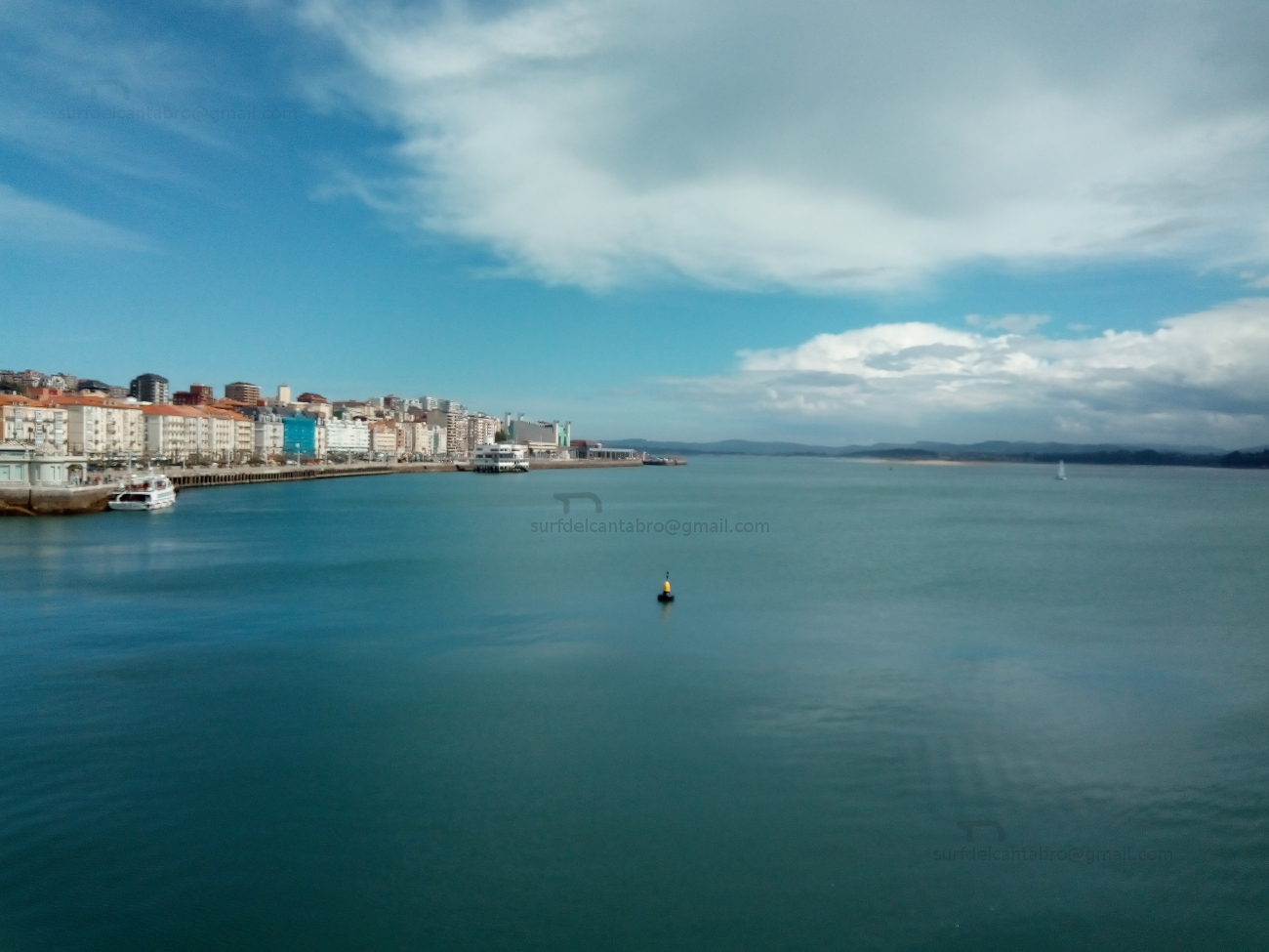
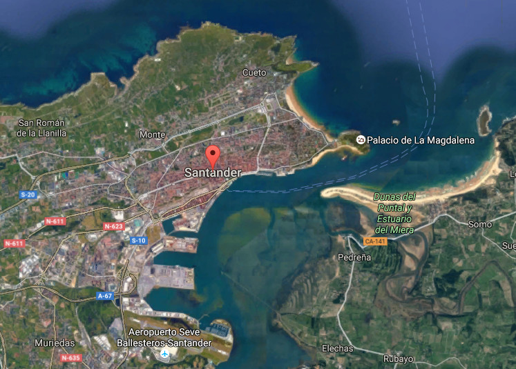
![]() Santander, ciudad emplazada en la costa central de Cantabria, es la capital cántabra. Su contorno habita con el Mar Cántabrico por el norte,este y sur. Su morfología y entorno configuran la ciudad a través de la bahía ,el mar y el puerto; ampliando su extensión hacia el oeste e interior.
Santander, ciudad emplazada en la costa central de Cantabria, es la capital cántabra. Su contorno habita con el Mar Cántabrico por el norte,este y sur. Su morfología y entorno configuran la ciudad a través de la bahía ,el mar y el puerto; ampliando su extensión hacia el oeste e interior.
La arquitectura de la ciudad va desde el gótico, destacando en la Catedral de Santander, hasta el siglo XXI,con los edificios de nueva construcción presentes. La Iglesia de la Anunciación perteneciente al Barroco, El Mercado de la Esperanza del siglo XIX… El edificio del Ayuntamiento articula su espacio entrono a una plaza que sitúa a sus pies, en las proximidades del centro y la artería principal de la ciudad. Más construcciones, barrios y calles la esculpen y hablan de su historia y carácter.
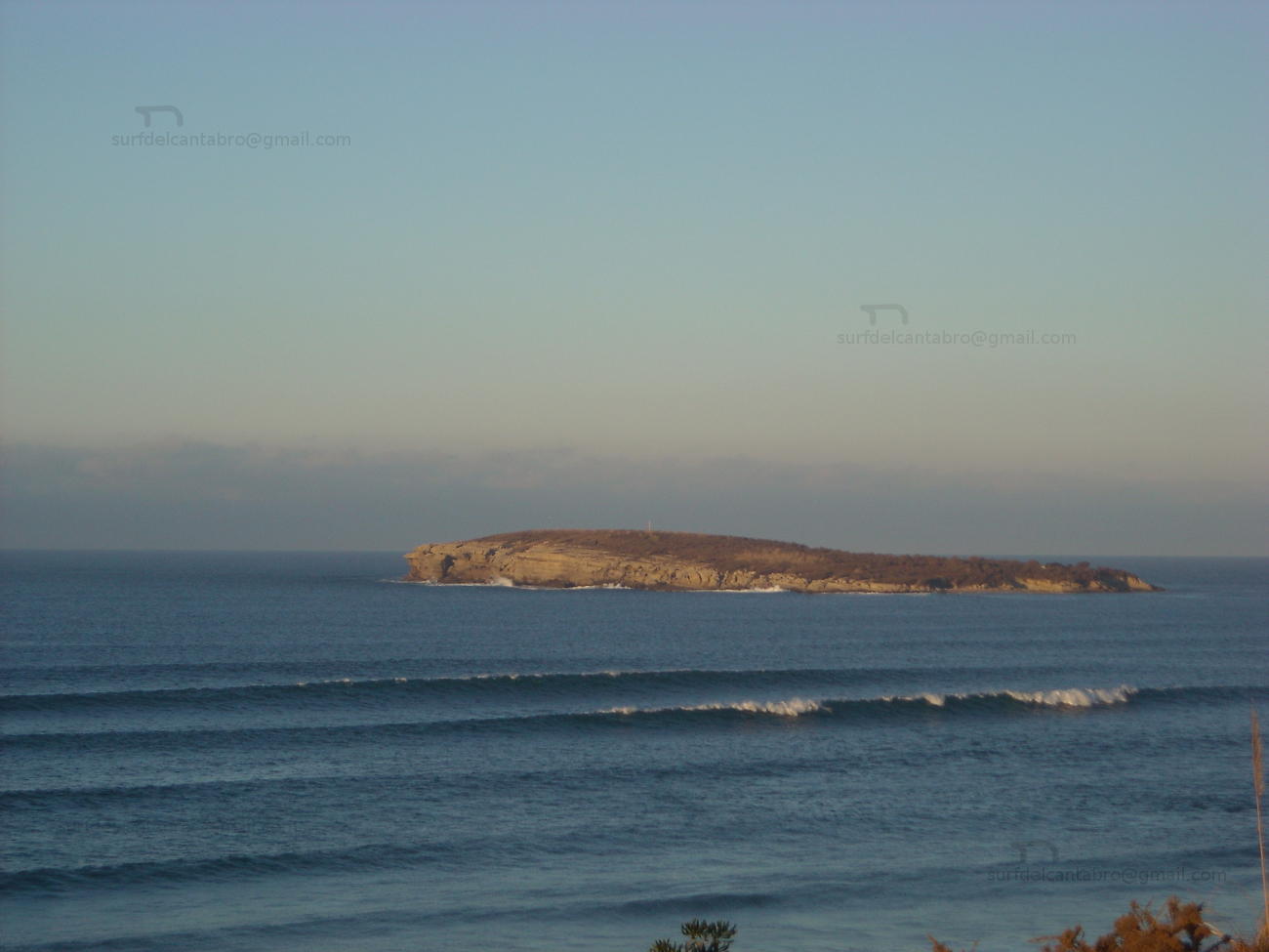
El Paseo marítimo y costero de la ciudad comienza en el puerto, prolongando su recorrido hasta el Palacio de la Magdalena y el Sardinero. El norte, accesible desde los barrios de Cueto y Monte, dispone de sendas que avanzan paralelas a la costa y son hábiles en ciertos tramos del recorrido. Desde el Faro de Cabo Mayor, punto más septentrional con acceso habilitado,se dispone de una perspectiva que dirige su atención hacia el mar y el oeste de Cantabria atravesando la entrada de la bahía que embellece y sustancia su esencia. La Isla de Mouro, a la entrada de la bahía, da testimonio del transito portuario y pesquero; ofreciendo un espectáculo singular con mar fuerte.
Santander, city
![]() Santander, city located in the central coast of Cantabria, is the Cantabrian capital. Its contour lives with the Cantabrian Sea for the north, east and south. Its morphology and environment form the city across the bay, the sea and the port; increasing its extension towards the west and inland.
Santander, city located in the central coast of Cantabria, is the Cantabrian capital. Its contour lives with the Cantabrian Sea for the north, east and south. Its morphology and environment form the city across the bay, the sea and the port; increasing its extension towards the west and inland.
The architecture of the city goes from the Gothic, standing out in the Cathedral of Santander, up to the 21st century, with the buildings of new construction that are present. The Church of the Annunciation belonging to the Baroque, The Market of the Hope of the 19th century… The building of the City hall articulates its space arround an square that is places to its feet, in the proximities of the center and the principal artery of the city. More constructions, neighborhoods and streets sculpt it and talk about its history and character.
The maritime and coastal promenade of the city begins in the port, prolonging its tour up to the La Magdalena Palace and the Sardinero. The north, accessible from the neighborhoods of Cueto and Monte, has paths that advance parallel to the coast and are skilful in certain sections of the tour. From the Lighthouse of Cape Mayor , the most north point with available access, is arranged of a perspective that directs its attention to the sea and the west of Cantabria, crossing the entry of the bay that it embellishes and substance its essence. Mouro’s Island, at the entry of the bay, gives testimony of the port and fishing traffic; offering a singular spectacle with strong sea.
![]()

 Santander, city

Pedreña, villa
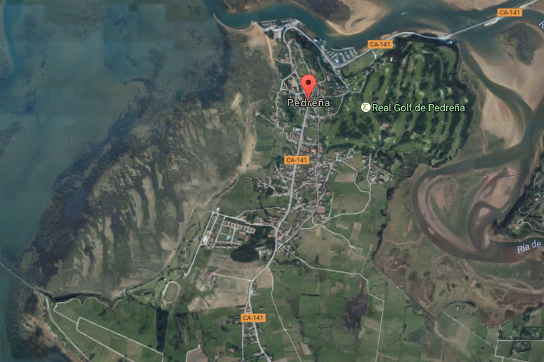
![]() Pedreña es una villa ubicada en la cara sur de la Bahía de Santander y perteneciente al municipio de Marina de Cudeyo. Su núcleo de población apenas alcanza los 1500 habitantes y ocupa un extenso territorio que contiene la carretera nacional que recorre el sur de la bahía, a la que se asoma, y conecta con el resto de villas costeras del entorno.
Pedreña es una villa ubicada en la cara sur de la Bahía de Santander y perteneciente al municipio de Marina de Cudeyo. Su núcleo de población apenas alcanza los 1500 habitantes y ocupa un extenso territorio que contiene la carretera nacional que recorre el sur de la bahía, a la que se asoma, y conecta con el resto de villas costeras del entorno.
El trazado sencillo de la villa descansa sobre casas de piedra, barrios, urbanizaciones de nueva construcción, prados y bosques. Su Paseo Marítimo descubre un trayecto de mediana extensión que conecta el muelle con el puerto deportivo. Ambos lados acompañan y lustran el camino. En una parte, un singular campo de golf; cuna de campeones. El otro lado recibe la brisa de la bahía acompañada de un paisaje único de Santander, el puerto y la bahía. EL final del paseo termina en el puente que une la localidad con Somo. Desde allí, podemos contemplar el final de la Ría de Cubas, una pequeña bahía de singular belleza por su forma y entorno poético que la rodea.
La parte oeste transita por barriadas de casas antiguas y edificios, servidos por una acera que acompaña todo el trayecto. Un campo de golf municipal cuyo contorno posee un camino que cuenta con bancos y enclaves desde donde disfrutar una nueva perspectiva de la capital cántabra acompañada del ancestral trabajo de las mariscadoras de Pedreña que faenan con la bajamar.
Pedreña, village
![]() Pedreña is a locality placed in the south face of the Bay of Santander and belonging to the municipality of Marina de Cudeyo. Its core of population scarcely reaches 1500 inhabitants and occupies an extensive territory that contains the national road that crosses the south of the bay, to which it appears, and connects with the rest of coastal villages of the surroundings.
Pedreña is a locality placed in the south face of the Bay of Santander and belonging to the municipality of Marina de Cudeyo. Its core of population scarcely reaches 1500 inhabitants and occupies an extensive territory that contains the national road that crosses the south of the bay, to which it appears, and connects with the rest of coastal villages of the surroundings.
The simple tracing of the villa rests on houses of stone, neighborhoods, urbanizations of new construction, meadows and forests. Its Maritime Promenade discovers a route of medium extension that connects the dock with the marina. Both sides accompany and shine the way. In a part, a singular golf course; champions’ cradle. Another side receives the breeze of the bay accompanied of the unique landscape of Santander, the port and the bay. The end of the walk finishes in the bridge that links the locality with Somo. From there, we can contemplate the Rivermouth of Cubas , an small bay of singular beauty for its form and poetical environment that surrounds it.
The part west passes along ancient attached houses and buildings, served by a sidewalk that accompanies the whole distance. A municipal golf course which contour possesses a way that has banks and enclaves from where enjoying a new perspective of the Cantabrian capital accompanied with the ancestral work of the gatherer of shellfish that labour with the low tide.
![]()

Pedreña, village