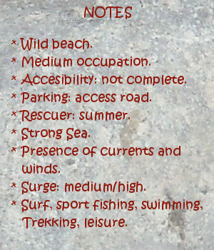
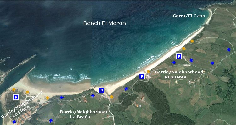
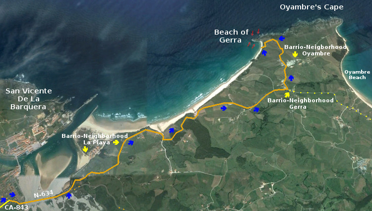
Gerra, playa

Icono Español. Icon Spanish. Gerra, playa La playa Gerra, también llamada El Cabo, se encuentra en el municipio de San Vicente de la Barquera; en la costa occidental de Cantabria. Situada en la cara oeste del cabo que une la costa de San Vicente de la Barquera con la costa de Oyambre, es una playa de 900 metros de longitud y una anchura media aproximada de 30 metros.

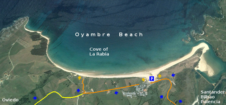
Su escarpado acceso esconde parcialmente a Gerra y da entrada a un emplazamiento idílico con vistas panorámicas, que en los días de buena visibilidad muestran parte de la costa asturiana y Los Picos de Europa. A los pies de los acantilados y protegida por El Cabo de Oyambre, recoge los vientos de la ensenada y las corrientes de la zona. Destaca la calidad de sus aguas, limpias y trasparentes, que dejan traslucir sus fondos cerca de la orilla; sólo enturbiada por las fuertes corrientes que hay en el área y el viento, presente de manera habitual.

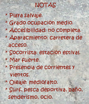
El emplazamiento de Gerra, entre acantilados y formaciones rocosas, hacen que su fondo arenoso se mezcle con rocas sueltas y diseminadas por todo el área. Las zonas cercanas a la orilla y próximas al pico PeñaEntera son evitables en la práctica del surf, pues además las corrientes son fuertes cerca de la pico montañoso que delimita a Gerra. Nacen las olas a 100 metros de la arena, siendo su recorrido de pequeña e «intensa» extensión. Abren sus olas a izquierdas y derechas, combandose por el trazado curvo de la playa, favoreciendo las maniobras y el viaje activo para su navegación.

Corre el aire, vuela sobre las aguas de Gerra, proporcionando energía a sus olas, moldeando sus formas. Prologando en el tiempo y en el espacio las paredes de agua que allí se forman. Si está ausente, es que ya pasó, y sobre las ondas reflejado queda su filtrado, su pulido acabado, sello característico de esta singular zona de la costa cántabra.
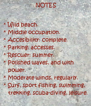
comic, mountain
Gerra, notas

Gerra, beach

Icono Inglés. Icon English. Gerra, beach The beach of Gerra, also called El Cabo, is in the municipality of San Vicente de la Barquera; on the western coast of Cantabria. Placed in the west side that joins the coast of San Vicente de la Barquera with Oyambre’s coast, is a beach of 900 meters of length and an average approximate width of 30 meters.

Its steep access hides partially Gerra and gives entry to an idyllic emplacement with panoramic view, that in the days of good visibility show part of the Asturian coast and the massif Picos de Europa. To the feet of the cliffs and protected by Oyambre’s Cape, which gathers the winds of the inlet and the currents of the zone. Stands out the quality of its waters, clean and clear, that show its funds near the shore; only muddied by the strong currents that exist in the area and the wind, present in an habitual way.

The emplacement of Gerra, between cliffs and rocky formations, which do that its sandy bottom mixes with free and scattered rocks in all the area. The zones near to the shore and next the beak PeñaEntera are avoidable in the practice of the surf, since in addition the currents are strong near its mountainous peak that delimits Gerra. The waves are born to 100 meters of the sand, being its tour with small and intense extension. It open its waves for left and rights sides, curving because of the curved tracing of the beach, favoring the maneuvers and the active trip for its navigation.

It traverses; the air, flies on Gerra’s waters, providing energy to its waves, molding its forms. It extend, in the time and in the space, the water walls that there are formed. If it is not in, it is that already it happened, and on the waves is reflected its filtered, its polished ended, typical stamp of this singular zone of the Cantabrian coast.

comic, mountain
Gerra, notes

Share

Oyambre, playa

Icono Español. Icon Spanish. Oyambre, playa La playa de Oyambre está situada en el municipio de Valdáliga, emplazado en la costa occidental de Cantabria. Situada dentro del Parque Natural de Oyambre, es un extenso arenal de 1800 metros de longitud dispuestos en linea recta y curvando su ala izquierda por la morfología de su entorno dominado por acantilados. El extremo derecho continúa a través de la costa cántabra hasta perderse en el horizonte.

La entrada a la playa se realiza a través de un pequeño aparcamiento habilitado para 50 vehículos, aproximadamente. La contemplación de Oyambre produce en el caminante una sensación acogedora e intima, que contrasta con la amplitud y enormidad del entorno. Salvaje y naturalmente dibujada, es recorrida por el viento en toda su plenitud que la visita de forma casi regular. Su extensión se plasma por medio de una llanura de arena endurecida, con una leve pendiente hasta la orilla, a modo de invitación para conocer sus aguas. La playa de oyambre, por sus características, sirvió en el siglo pasado de pista de aterrizaje del llamado «Pájaro amarillo»; primer avión que cruzó el Océano Atlántico en una travesía de 29 horas. Esto da una idea de la singularidad del lugar.

Baña el Mar la costa y la playa, ondula suavemente el fondo arenoso por los efectos de las mareas y el oleaje. Aparecen las ondas en diversos picos de olas que existen en la playa. Su forma pulida y recorrido alargado,en la zona central, se combina con áreas donde estas recorren menor extensión y favorecen las maniobras. Golpea el Mar Cantábrico al surfista, iniciando así la navegación, naciendo su viaje sobre las olas. Travesía prolongada y colmada, pues a la energía que inyecta la velocidad se suma la pureza del agua, del aire, la belleza de la costa al fondo, que por sensaciones llegan a uno mismo y terminan por prender el fuego en el interior.

comic, mountain
Playa de Oyambre, notas

Oyambre, beach

Icono Inglés. Icon English. Oyambre, beach The beach of Oyambre is placed in the municipality of Valdáliga, located in the western coast of Cantabria. Housed inside the Nature Reserve of Oyambre, it is an extensive sandbank of 1800 meters of length arranged on straight line; with a left wing curved because of the morphology of its environment dominated by cliffs. The right wing continues across the Cantabrian coast up to getting lost in the horizon.

The entry to the beach is realized across an small parking enabled for 50 vehicles, approximately. Oyambre’s contemplation produces in the wayfarer a cozy and intimate sensation, that contrasts with its length and enormity of its environment. Wild and naturally drawn, is crossed by the wind in all its fullness that visits it almost regularly. Its extension takes form by means of a plain of hard sand, with a slight earring up to the shore, as an invitation to know his waters. The beach of Oyambre, for its characteristics, was used int the last century as a runway of the so called yellow Bird; the first plane that crossed the Atlantic Ocean in a voyage of 29 hours. This gives an idea about the singularity of the zone.

The Sea bathes the coast and the beach, it waving softly the sandy bottom due to the effects of the tides and the surge. The waves appear in diverse beaks that exist in the beach. Its polished form and elongated tour, in the central zone, combines with areas where them are in less extension and allow the maneuvers. It strikes the Cantabrian Sea to the surfer, initiating in this way the navigation, borning his trip on the waves. Long and fulfilled voyage, because at the energy that injects the speed is added the purity of the water, of the air, the beauty of the coast in the background, which through its sensations come to oneself and them end for lighting the fire inside.

comic, mountain
Oyambre beach, notes

Share

Playa de Comillas, acceso

Icono Español. Icon Spanish. Playa de Comillas, La playa de Comillas está situada en el municipio de Comillas, en la costa occidental de Cantabria. Es una playa urbana, ubicada dentro de la localidad. Está bordeada por un Paseo Marítimo, al que se llega atravesando Comillas. Cuenta con un amplio aparcamiento y varios puntos de entrada al arenal.

Comillas Beach, access

Icono Inglés. Icon English. Playa de Comillas, The beach of Comillas is placed in the municipality of Comillas, in the western coast of Cantabria. It is an urban beach located inside the locality. It is bordered by a promenade, to which you will arrive through the city. It possesses a wide parking and several points of entry to the sandbank.

Icono español-inglés. Icon Spanish-English. Playa de Comillas, Acceso/Access

Acces: Comillas beach

Icon close Sponsor

Share

Playa de Comillas, localización

Icono Español. Icon Spanish La playa de Comillas se encuentra en la localidad de Comillas, ubicada en la costa occidental de Cantabria. El viaje se realiza por autovía , finalizando por la carretera nacional CA-135; desde el este y CA-131 desde el oeste. Se muestran a continuación como puntos de partida Oviedo, Palencia, Santander y Bilbao.

Comillas beach, localization

Icono Inglés. Icon English The beach of Comillas is in the locality of Comillas, placed in the western coast of Cantabria. The trip is realized by motorway, finishing for the national road CA-135; from the east and CA-131 from the west. Shown below as starting points Oviedo, Palencia, Santander and Bilbao.

Icono español-inglés. Icon Spanish-English Localización/Localization

Oviedo, Playa de Comillas: LocalizationPalencia, Playa de Comillas: localizationBilbao, Playa de Comillas: localizationSantander, Playa de Comillas: localization

Share

Playa El Merón, acceso

Icono Español. Icon Spanish La playa El Merón está situada en el municipio de San Vicente de la Barquera. Desde los barrios de : La Playa, La Braña y Rupuente se accede directamente a la playa por distintas zonas. Tiene todos los servicios y amplias zonas de aparcamiento.

Beach El Merón, access

Icono Inglés. Icon English The beach El Merón is placed in the municipality of San Vicente de la Barquera. From the neighborhoods of: La Playa, La Braña and Rupuente, you can access to the beach for different zones. It has all the services and wide zones of parking.

Icono Español-Inglés. Icon Spanish-English Acceso/Access

Playa El Merón, acceso, access

Icon close Sponsor

Share

Playa El Merón, localización

Icono Español. Icon Spanish. Playa el Merón, localización La playa El Merón está situada en el municipio de San Vicente de la Barquera, en la costa occidental de Cantabria. El trayecto transcurre por autovía y finaliza a través de las carreteras nacionales: CA-843 y N-634. La ruta finaliza en el Barrio de Rupuente, antes encontraremos cualquiera de los accesos al arenal. Se muestran a continuación como puntos de partida Oviedo, Palencia, Santander y Bilbao.

Beach El Merón, localization

Icono Inglés. Icon English The beach El Merón is placed in the municipality of San Vicente de la Barquera, in the western coast of Cantabria. The travel passes for motorway and finishes across the national roads: CA-843 and N-634. The route ends in the Neigborhood of Rupuente, we will find one of the accesses to the sandbank before it. Shown below as starting points Oviedo, Palencia, Santander and Bilbao.

Icono Español-Inglés. Icon Spanish-English. Playa el Merón, localización Localización/Localization

Oviedo, Merón: LocalizationPalencia, Merón: LocalizationBilbao, Merón: LocalizationSantander, Merón: Localization

Icon close Sponsor

Share

Playa de Gerra, Acceso

Icono Español. Icon Spanish. playa de gerra, La Playa de Gerra tiene un único acceso. Se puede llegar hasta la playa desde el oeste o desde el este. La ruta occidental atraviesa parte de San Vicente de la Barquera (Barrio de La Playa, Barrio de Gerra, Barrio de Oyambre). La ruta oriental corre paralela a la Playa de Oyambre, continua hacia el Barrio de Gerra y finaliza en el Barrio de Oyambre. En ambos trayectos debemos elegir el desvío zurdo de la carretera.

Beach of Gerra. Access

Icono Inglés. Icon English. playa de gerra, The beach of Gerra has only one access. It is possible to arrive to the beach from the west or from the east. The western route crosses San Vicente de la Barquera (Neighborhood of La Playa, Neighborhood of Gerra, Neighborhood of Oyambre). The oriental route runs parallel to Beach of Oyambre, continues towards the Neighborhood of Gerra and finishes in the Neighborhood of Oyambre. In both routes, we must choose the left detour of the road.

Icono Español-Inglés. Icon Spanish-English. playa de gerra, Acceso/Access

Beach of Gerra, access
Oyambre:  localizationPlaya de Gerra, acceso, access

Share

Playa de Gerra, Localización

Icono Español. Icon Spanish. Playa de Gerra La Playa de Gerra o El Cabo está situada en el municipio de San Vicente de la Barquera, en la costa occidental de Cantabria. Esta playa se encuentra en la cara oeste del Cabo de Oyambre. El viaje se realiza por autovía y finaliza a través de las carreteras nacionales: CA-843 y N-634. La ruta oficial finaliza en el Barrio de Oyambre. Una vez allí coger el desvío de la izquierda que finaliza en la Playa de Gerra.

Beach of Gerra, localization

Icono Inglés. Icon English The Beach of Gerra or El Cabo is located in the municipality of San Vicente de la Barquera, on the west coast of Cantabria. This beach is placed on the west side of the Cape of Oyambre. The travel is done by motorway and ends through the national roads: CA-843 and N-634. The oficial route ends in the Neighborhood of Oyambre. Once there, take the detour to the left that ends at the Beach of Gerra.

Icono Español-Inglés. Icon Spanish-English. Playa de Gerra Localización/Localization

Oviedo, Gerra: LocalizationPalencia, GerraL: localizationBilbao, Gerra: LocalizationSantander, Gerra: localization

Icon close Sponsor

Share

Playa de Oyambre, acceso

Icono Español. Icon Spanish La Playa de Oyambre tiene dos accesos. El primero está situado en la parte más occidental de la playa y es la entrada a la que se llega por el oeste; a través de la carretera nacional N-634. El segundo acceso es la entrada principal y está situado en la parte más oriental. Cuenta un amplio parking que está contiguo a la playa. A esta entrada se llega desde el este, por la carretera nacional CA-131.

Beach of Oyambre, access

Icono Inglés. Icon English The Beach of Oyambre has two accesses. The first one is placed in the most western part of the beach and is the entry to the one that comes near for the west; through the national road N-634. The second access is the principal entry and is placed in the most oriental part. It has a wide parking that is contiguous to the beach. This entry is to the one that comes from the east, through the national road CA-131.

Icono Español-Inglés. Icon Spanish-English Acceso/Access

Playa de Oyambre, access

Icon close Sponsor

Share

Playa de Oyambre, localización

Icono Español. Icon Spanish. Playa de Oyambre La Playa de Oyambre está situada en el municipio de Valdaliga. Esta playa se encuentra dentro del Parque Natural de las Dunas de Oyambre, que se extiende a través de varios municipios, en la costa occidental de Cantabria. El viaje se realiza por autovía y finaliza a través de las carreteras nacionales: N-634 por el oeste y CA-131 por el este.

Beach of Oyambre, localization

Icono Inglés. Icon English. Playa de Oyambre Oyambre’s Beach is placed in the municipality of Valdaliga. This beach is in the Nature Reserve of Oyambre’s Dunes, that it spreads across several municipalities, on the western coast of Cantabria. The travel runs by highway and finishes through the national roads: N-634 from the west and CA-131 from the east.

Icono Español-Inglés. Icon Spanish-English. Playa de Oyambre Localización/Localization

Oviedo, Oyambre: LocalizationPalencia, Oyambre: LocalizationBilbao, Oyambre: LocalizationSantander, Oyambre: localization

Icon close Sponsor

Share