Playa de Los Locos, acceso

Icono Español. Icon Spanish. playa de los locos, La Playa de Los Locos cuenta con un acceso al que se puede llegar desde el pueblo de Tagle, o la localidad de Suances. Ambos accesos se realizan por carratera nacional y comparten parte del trayecto final. Cuenta con dos zonas de parking separadas. La primera zona está más alejada de la entrada a la playa. El segundo parking da acceso directo a la Playa Los Locos.

Beach of Los Locos, access

Icono Inglés. Icon English. playa de los locos, The Beach of Los Locos has an access which can be reached from the village of Tagle or the town of Suances. Both accesses are performed by national road and share the end trip. Account with two separate parking areas. The first area is farthest from the entrance to the beach. The second car park gives direct access to the Los Locos Beach.

Icono Español-Inglés. Icon Spanish-English. playa de los locos, Acceso/Access

Acceso: Playa de Los Locos

Icon close Sponsor

Share

Playa de Los Locos, Localización

Icono Español. Icon Spanish. Playa de Los Locos La Playa de Los Locos está localizada en el municipio de Suances. Se puede llegar a Los Locos desde: Oviedo, Palencia, Santander ó Bilbao. Todos los trayectos son por autovía, finalizando el viaje por carretera nacional. Cualquier otro punto de origen comparte o atraviesa uno o varios de los puntos de partida anteriores.

Beach of Los Locos, localization

Icono Inglés. Icon English. Beach Los Locos Los Locos Beach is located in the municipality of Suances. You can get to Los Locos Beach from: Oviedo, Palencia, Santander or Bilbao. All trips are by motorway, ending the trip through the national road. All other departure points share one or several of the previous points of origin.

Icono Español-Inglés. Icon Spanish-English. Playa de Los Locos. Beach Los Locos Localización/Localization

Oviedo, Los Locos: LocalizationPalencia, Los Locos: LocalizationBilbao, Los Locos: LocalizationSantander, Los Locos: localization

Icon close Sponsor

Share

La Vaca, Acceso

Icono Español. Icon Spanish. La Vaca, La Vaca es accesible desde el Barrio Monte-Corbanera de la ciudad de Santander. Una vez en esta zona y siguiendo los carteles indicativos, nos dirigimos hacia el Instituto Español de Oceanografía. En la parte trasera del IEO existe un área a modo de parking. Desde el aparcamiento vemos la playa de El Bocal. A la derecha, siguiendo un pequeño sendero externo a las fincas privadas de la zona, se encuentra la última cala. Allí es donde se forma la ola gigante de La Vaca.

La Vaca, access

Icono Inglés. Icon English. La Vaca, La Vaca is accessible from the Neighborhood Monte-Corbanera of the city of Santander. Once in this area and following the signs, we headed toward the Spanish Institute of Oceanography (IEO). At the rear of the IEO there is an area for parking. From the parking area we see the beach of El Bocal. To the right, through a small trail that is out of the private farms in the area, is the last cove. This is where grows the big wave called La Vaca.

Icono Español-Inglés. Icon Spanish-English. La Vaca, Acceso/Access

Acceso/Access: La Vaca,

Icon close Sponsor

Share

La Vaca, Localización

Icono Español. Icon Spanish La Vaca está localizada en el barrio de Monte-Corbanera, situado en la costa norte de la ciudad de Santander. Su localización es complicada, ya que este spot no se encuentra registrado en las guías de viajes y mapas. Los enlaces que se muestran más abajo finalizan su trayecto en el Barrio Monte-Corbanera. De allí cogemos el desvío hacia el Instituto Español de Oceanografía (derecha), que cuenta en su parte trasera, con una pequeña zona a modo de parking. En la zona hay varios carteles que indican la dirección hacia el IEO. Una vez en el aparcamiento, vemos la entrada a la Playa del Bocal. La siguiente cala, situada a la derecha, es: La Vaca. Se muestran como puntos de partida Oviedo, Palencia, Santander y Bilbao, el resto de orígenes comparte el final del trayecto con esas localizaciones.

La Vaca, Localization

Icono Inglés. Icon English La Vaca is located in the neighborhood of Monte-Corbanera , placed on the north coast of the city of Santander. Its location is complicated, because this spot is not registered in the travel guides and maps. The links shown below end the journey at the neighborhood Monte-Corbanera . From there you have to take the detour to the Spanish Institute of Oceanography (IEO) (right), which has in his rear, a small area by way of parking. In the zone there are several signs indicating the direction toward the IEO. Once in the parking lot, we see the entrance to the Beach of EL Bocal. The next cove, situated to the right, is: La Vaca. Are shown as points of departure Oviedo, Palencia, Santander and Bilbao, the rest of origins shares the end of the journey with these localizations.

Icono Español-Inglés. Icon Spanish-English Localización/Localization

Oviedo, La Vaca: LocalizationPalencia, La Vaca: LocalizationBilbao, La Vaca: LocalizationSantander, La Vaca: localization

Icon close Sponsor

Share

De La Maruca a La Vaca. Ruta de Senderismo

Icono Español. Icon Spanish. Ruta: De La Maruca a La Vaca
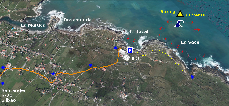
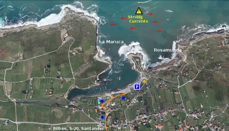
La Maruca está ubicada en la localidad de Monte, perteneciente al municipio de Santander. Es la Maruca un puerto natural emplazado en la costa norte de la ciudad y blasonada por la orografia del litoral que esculpe el Mar Cantábrico.

Su paseo marítimo cuenta con un amplío parking desde donde comenzar la ruta. Una vez situados en ese punto, podemos contemplar la belleza de este puerto. Pequeñas barcas de pescadores se agolpan hacia el interior y el lado izquierdo del mismo. Allí desemboca la Ría de San Pedro, contribuyendo a modelar la singular forma de La Maruca. Al alcance de nuestra vista se eleva una estatua gigante de un pescador, homenaje a la gente del mar. En el lado derecho del paseo marítimo se puede visitar el Centro de Interpretación del Litoral, pequeño museo dedicado al mar y la costa de Cantabria.

Continuando el camino, a la otra parte del CIL, aparece la Playa de Rosamunda. Es pequeña y sólo hábil en marea baja. Su principal uso esta destinado a la pesca recreativa desde sus rocas. Los días en los que la mar esta plana es posible realizar submarinismo. Doradas, perlas, salmonetes, y jargos son algunas de las espcecies de peces que podemos encontrar. Su fondo rocoso e irregular se entremezcla con la arena que el oleaje deposita en la base de esta zona. Un momento de pausa en este lugar hace que los límites de La Maruca varíen y difuminen sus fronteras entre el azul del cielo nuboso y el azul oscuro del mar.

Ahora el sendero transcurre paralelo al acantilado, marcado en el suelo por el uso. El oleaje al encuentro con las rocas dispara el agua, haciendo que la espuma se suspenda en el aire. Las pequeñas gotas de agua y el olor puro del mar acompañan la travesía. En el otro extremo, y después de atravesar este escenario, la arena abundante en una esquina nos hace intuir la entrada natural y más cómoda a la playa.

Llegamos a un pequeño cabo dentro de este entorno. Entre los muros de las fincas particulares y el mar, se encuentra la roca por la que caminamos. Va perdiendo gradualmente su altura hasta finalizar a nivel del mar. La última parte del tramo es un acantilado a cuyo resguardo llegan las olas que entran en la Playa del Bocal. Su irregular fondo de roca, afilada por las olas, aumenta el disfrute de esta imagen contemplada desde tierra firme. Nacen , en la distancia cercana, unas olas características. Su tamaño medio y su definido recorrido estimulan la imaginación. Cuando las olas crecen de tamaño, succionan con mayor fuerza el fondo, dejando entrever a poca distancia de la superficie del agua, el fondo rocoso. A nuestra espalda, una base el Instituto Español de Oceanografía.

Al final de este tramo asoma la entrada a la Playa del Bocal. Avanza el sendero irregularmente hasta llegar a campo abierto. Las vacas pastan libres en este lugar. Una valla electrificada las separa de los caminantes. Paso a paso subimos una pequeña y suave colina formada por vegetación y roca kárstica. Desde ella divisaremos la última cala del trayecto, aquella donde se origina y habita una de las olas más grandes de Cantabria: La Vaca Gigante.

La Maruca to La Vaca. Trekking route

Icono Inglés. Icon English. Route: La Maruca to La Vaca La Maruca is located in the town of Monte, belonging to the municipality of Santander. It is a natural harbor located on the north coast of the city and blazon by the orography of the coastline that sculpts the Cantabrian Sea.

Its promenade has a large car park from where to begin the route. In that point, we can contemplate the beauty of the port. Small fishing boats are crowded toward the inside and the left-hand side of the same. That place is The Stuary of San Pedro, helping to shape the unique configuration of La Maruca. In the scope of the view is raised a giant statue of a fisherman, a tribute to the people of the sea. On the right side of the promenade you can visit the Interpretation Center of the Coastline, small museum dedicated to the sea and the coast of Cantabria.

Continuing along the path, to the other part of the CYL, appears the Beach of Rosamunda. It is small and only available at low tide. Its main use is intended for the recreational fishing from the rocks. The days on which the sea is flat it is possible to make scuba diving. Gold, pearls, red mullet, and jargos are some of the espcecies of fish that we can find. Its rocky bottom and irregular is intermingled with the sand that the waves deposited in the base of the zone. A moment of pause in this place makes the limits of La Maruca may vary, and blur their boundaries because of the blue of the sky , the clouds and the dark blue of the sea.

Now the path runs parallel to the cliff face, marked on the ground by use. The waves to the encounter with the rocks shoot the water, making that the foam is suspended in the air. The small drops of water and the fresh sea smell accompany the voyage. On the other end, and after crossing this scenario, the sand in a abundant corner makes us sense the natural and more convenient entrance to the beach.

We arrived in a small cape within this environment. Between the walls of the private farms and the sea, is the rock through which we walked. It gradually lose their height up to finish at sea level. The last part of the zone is a cliff which guards the arrival of the waves that fall on the Beach of El Bocal. Its irregular rocky sea bottom, sharpened by the waves, increases the enjoyment of this image when we see it from the mainland. Some particular waves appear in the close distance. Its medium size and its defined path stimulate the imagination. When the waves grow in size, the sea sucks with greater force the fund, showing the rocky bottom near the surface of the water. To our backs, a basis of the Spanish Institute of Oceanography.

At the end of this stretch is the entrance to the beach El Bocal. The trail moves irregularly until you get to open field. The cows graze free in this place. An electric fence separates the hikers from the animals. Step by step we climb a small and soft hill, formed by vegetation and karstic rock. There we will see the last cove of the journey, where borns and inhabits one of the biggest waves in Cantabria: «La Vaca Gigante».
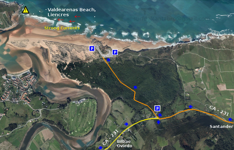
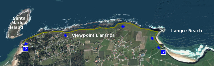
Icon close Sponsor

Share

La Maruca, acceso

Icono Español. Icon Spanish. La Maruca, acceso La Maruca puede ser accedida desde muchos puntos. La Albericia, Monte, Cueto, y Valdenoja son barrios de Santander desde los cuales se puede llegar directamente a La Maruca. Debido a que la costa norte de la ciudad esta compuesta principalmente por casas individuales y una red de carreteras dispuestas en el terreno a modo de laberinto, es aconsejable usar los puntos de entrada que están señalizados en la vía de salida de la autovía S-20.

La Maruca, access

Icono Inglés. Icon English. La Maruca, access La Maruca can be accessed from many points. La Albericia, Monte, Cueto, and Valdenoja are neighborhoods of Santander from which you can reach directly to it. Due to the fact that the north coast of the city is mainly composed of individual houses and a network of small roads that seems a maze, it is advisable to use the entry points that are flagged in the exit path of highway S-20.

Icono Español-Inglés. Icon Spanish-English. La Maruca, acceso, access Acceso/Beach Access

Acceso: La Maruca

Icon close Sponsor

Share

La Maruca, Localización

Icono Español. Icon Spanish La Playa de La Maruca está situada en la ciudad de Santander. Es una playa semiurbana emplazada en la costa norte de la ciudad. Compuesta por rocas y arena, se situa entre acantilados que reducen su tamaño hasta desembocar en el paseo marítimo que da acceso a la playa. A la Maruca se puede llegar desde el centro de Santander o por autovía (S-20). Se muestra a continuación como puntos de partida Santander y Bilbao. El resto de orígenes finalizarán en la ruta que enlaza Santander con La Maruca o en la parte final del trayecto que se inicia en Bilbao.

La Maruca, Localization

Icono Inglés. Icon English The Beach of «La Maruca» is located in the city of Santander. It is a semi-urban beach located on the north coast of the city. It is Composed of rocks and sand, is located between cliffs that reduce its size up to lead to the promenade that gives access to the beach. «La Maruca» can be reached from the center of Santander or through the highway (S-20). Shown below as starting points Santander and Bilbao. The rest of origins will finish in the route that connects Santander with «La Maruca» or in the final part of the journey that starts in Bilbao.

Icono Español-Inglés. Icon Spanish-English Localización/Localization

Oviedo, La Maruca: LocalizationPalencia. La Maruca: LocalizationBilbao, La Maruca: LocalizationSantander, LaMaruca: localization

Icon close Sponsor

Share

De Liencres a Portio. Ruta de senderismo

Icono Español. Icon Spanish. De Liencres a Portio La Playa de Valdearenas está ubicada en el municipio de Liencres y es conocida también por el nombre de su localidad. Los accesos a la playa cuentan con dos amplias zonas de aparcamiento. El parking situado más a la derecha da acceso a una carretera comarcal que se extiende a lo largo de 3 km hasta llegar a la Playa de Portio.

Allí empieza una ruta que avanza paralela a la costa. Esta zona es una parte de la Costa Quebrada, que va desde las Dunas de Liencres hasta la Península de la Magdalena, en Santander. El camino lo podemos realizar por la carretera. Tiene esta un escaso transito de vehículos fuera de la estación estival. La otra opción consiste en seguir un pequeño sendero marcado en el recorrido por el paso de los caminantes y que se localiza cercano a los acantilados.

El primer tramo transita cercano a una parte del Pinar de Liencres. En el pinar contrasta la altura de su árboles y sus colores con el tono cobrizo del suelo del bosque. Lecho formado por las hojas secas de los pinos. Esta imagen provoca la reminiscencia de una parte del antiguo bosque cántabro, presente en todo el territorio hasta llegar al mar. Hay pequeñas cuestas y suaves descensos que sirven de calentamiento para el resto de la ruta. Al otro lado se encuentra la Playa de Canallave. De pequeña extensión, cuenta con un arenal amplio salpicado de rocas modeladas por el oleaje. Comienza aquí el disfrute del paisaje y la imaginación.

La segunda parte del recorrido se hace a campo abierto. Rodeado de verde pradera hasta donde alcanza la vista. Mirando los prados, y siguiendo su línea, encontramos el Monte Tolio que acota esta semillanura. Siguiendo el sendero aparece un descenso que finaliza casi a nivel del mar. Desde este punto asoma una parte de la Playa del Madero. Continuando, después de una ligera cuesta, empieza la pedregosa entrada a esta especial cala. Colocada en el trazo interno del acantilado que la mar ha esculpido y delimitado del oleaje por una pared vertical de roca antigua. Para finalizar este tramo el camino elevado nos conducirá hasta la Playa de Somocuevas. Tiene un dificultoso acceso y la rodea un marco único que baña la playa por este y oeste.

El último tramo se realiza recorriendo el borde de la ensenada que baña las playas y calas que en ella existen. La Playa de las Cerrias se va acercando a cada paso. Descubre esta pequeña cala una zona de baño colocada dentro de la ensenada. 200 metros después está Llatas. La cala que muestra, por efecto de la erosión del mar, la base del acantilado. Finalmente llegamos a la Playa de Portio. La de mayor extensión y protegida por un respaldo rocoso en forma de media luna, vestigio de la forma prehistórica de esta parte de la costa.

Consejo : tener precaución.

Liencres to Portio. Trekking route

Icono Inglés. Icon English Valdearenas Beach is located in the municipality of Liencres and is also known by the name of its locality. The accesses to the beach are equipped with two large parking areas. From the parking that is located more to the right gives access to a county road that stretches along 3 km until you reach the Portio beach.

There begins a path that moves parallel to the coast. This area is a part of The Quebrada Coast, that goes from The Dunes of Liencres up to the Peninsula de la Magdalena, in Santander. The route can be perform through the road. It has a little transit of vehicles outside of the summer season. The other option is to follow a small trail marked on the route through the passage of the walkers and that is located close to the cliffs.

The first stage passes close to a part of the Pinar de Liencres. In the Pine forest contrasts the height of the trees and their colors with the coppery hue of the forest floor. The bed is formed by the dry leaves of the pines. This image is reminiscent of one part of the old cantabrian forest, present in the whole territory until reaching the sea. There are small hills and mild reductions that serve as a warm-up for the rest of the path. On the other side is placed Canallave Beach. It has a small extension, arenal account with a large rock-strewn modeled by the swell. Starts here the enjoyment of the scenery and the imagination.

The second part of the trip is done in the open countryside. Surrounded by green meadow as far as the eye can see. Looking the meadows, and following its line, we find the Mount Tolio limiting this plain. Continuing the path that end lower, almost at sea level. From this point overlooking a part of the Madero Beah. Then a slight hill begins the pebbled entrance to this special cove. Positioned in the stroke internal of the cliff that the sea has sculpted and it is protected of the surf by a vertical wall of old rock. To finish this stretch of the elevated road will lead us to the Somocuevas Beach. Has a difficult access and the surrounds a single framework that bathes the beach by east and west.

The last stretch is realized covering the rim of the big cove that bathes the beaches that in it exist. The
Beach of the Cerrias is approaching every step. There discovers this small cove an area of bath placed inside the big cove. 200 meters later is Llatas. The cove that shows, for effect of the erosion of the sea, the base of the cliff. Finally we come to the Beach of Portio. That of major extension and protected by a rocky support in the shape of half moon, trace of the prehistoric form of this part of the coast.

Advice: take caution.

icono separador forja, aperturaicono español-inglés en horizontalLiencres,Portio: routeicono separador forja, cierre

Icon close Sponsor

Share

Valdearenas ,Liencres; acceso

Icono Español. Icon Spanish La Playa de Valdearenas, También conocida como Liencres, tiene acceso desde el este por Santander, atravesando una ruta pintoresca que cruza parte de la ciudad y las localidades de San Román, Liencres y Soto de la Marina. Finaliza esta ruta por la carretera nacional CA-231. El acceso desde el oeste por Oviedo se realiza por autovía, finalizando el trayecto por la carretera nacional CA-231. El acceso desde Bilbao comienza por el este y finaliza por la parte oeste de la carretera nacional CA-231.

Valdearenas, Liencres; access

Icono Inglés. Icon English Valdearenas Beach, also known as Liencres, has access from the east by Santander, going through a picturesque route that crosses part of the city and the towns of San Roman, Liencres and Soto of the Marina. The end of this travel runs through from the national highway CA-231. The access from the west by Oviedo is performed by motorway, ending the journey from the national highway CA-231. The access from Bilbao begins on the east and ends in the western part of the national highway CA-231.

Icono Español-Inglés. Icon Spanish-English Acceso/Beach Access

Acceso:Valdearenas,Liencres

Icon close Sponsor

Share

De Langre a Santa Marina. Ruta de senderismo

Icono Español. Icon Spanish La Playa de Langre esta ubicada en el municipio de Langre. Su entrada principal , situada más a la izquierda; posee una carretera asfaltada que termina en un mirador natural con una barandilla de madera. Desde este lugar se contempla la playa de Langre en su totalidad y el camino que la costa Cántabrica traza entre la roca y el mar. Galizano detrás, y al fondo, a lo lejos se intuye el Cabo Quintres.

A mano izquierda de este mirador comienza un pequeñito sendero. Dibujado sobre la hierba por los pasos que lo transitan. Transcurre paralelo al borde de los acantilados que hay entre la Playa de Langre y la Isla de Santa Marina a lo largo de 3,5 km. Ligeras cuestas y suaves descensos amenizan el trayecto que se desarrolla dentro de un paisaje que impregna el ambiente como una música ambiental. Conforme avanzamos, va apareciendo la ciudad de Santander y su bahía, proporcionando diferentes perspectivas de una misma postal.

En la parte central del recorrido se encuentra el Mirador de Llaranza. Con una extensión aproximada de 1 km, cuenta en su base; a nivel del mar, con unas piscinas naturales de la misma longitud. Formadas sobre una plataforma de abrasión. Son una fotografía de irregular y natural figura, tallada por el Mar Cantábrico a lo largo de los siglos. Este punto es un buen lugar para hacer una parada y alcanzar la paz, por medio la contemplación de la belleza que la naturaleza muestra.

Al final de la ruta nos encontramos con la Isla de Santa Marina. La mayor de las islas de Cantabria, con una extensión de 18,5 hectáreas. Separada de la línea de costa por apenas 15 metros en su parte más cercana a ella. Constituye en sí misma y en el entorno en el que se ubica un emplazamiento único y abundante en estímulos.

Mirando al horizonteen cualquier punto del recorrido, una sensación de libertad empapa el espíritu. Unas sonrisas aparecen al intentar distinguir, a lo lejos, la fina e indefinida línea que separa el Mar Cantábrico del cielo.

Consejo : tener precaución.

Langre, Santa Marina. Trekking route

Icono Inglés. Icon English The Langre Beach is located in the municipality of Langre. Its main entrance, located more to the left; it has a paved road that ends at a lookout point with a natural wood handrail. From this place you can see the Langre beach in its entirety and the way that the Cantabrian coast draws between the rock and the sea. Galizano behind, and the fund, in the distance one perceives the Cape Quintres.

To left hand of this lookout a tiny footpath begins. Drawn on the grass for the steps that journey have caused. Runs parallel to the edge of the cliffs that exist between the Beach of Langre and the Island of Santa Marina. Its length has 3,5 km. Medium slopes and soft descents liven up the trajectory that develops inside a scenery that impregnates the ambience as an environmental music. As we advance, appears the city of Santander and its bay, providing different perspectives of the same postcard.

In the central part of the tour is the lookout of Llaranza. With an approximate length of 1 km, has in its base; at sea level, some natural pools of the same length. Formed on an abrasion platform. They are a picture of irregular and natural figure, carved by the Cantabrian Sea throughout the centuries. This point is a good place to stop and achieve peace, through the contemplation of the beauty that nature shows.

At the end of the path we found with the island of Santa Marina. The largest of the islands of Cantabria, with an extension of 18.5 hectares. Separated from the coastline by a mere 15 feet at its closest to it. It is in itself and in the environment in which it is located a unique location and abundant in stimuli.

Looking at the horizon in anywhere along the route , a freedom sensation soaks the spirit. A few smiles appear on having tried to distinguish, in the distance, the thin and indefinite line that separates the Cantabrican Sea of the sky.

Advice: take caution.

Separador. DividerIcono Español-Inglés. Icon Spanish-EnglishLangre,Santa Marina: LlaranzaIcono separador. Icon divider

Icon close Sponsor

Share