Langre, acceso a la playa

Icono Español. Icon Spanish La playa de Langre tiene dos vías de acceso. La primera vía está situada a la izquierda en el mapa, da entrada a la playa más pequeña de Langre, de las dos que componen el arenal. Es una zona ideal para el baño. El segundo acceso desemboca en la playa grande, que tiene unas condiciones especiales para practicar Surf.

Langre, access to the beach

Icono Inglés. Icon English The Langre beach has two access routes. The first route placed to the left in the map, leads to the smallest beach of Langre, one of the two beaches that are in the zone. It is an ideal area for swimming. The second way ends in the big beach. This beach has ideal conditions to Surfing.

Langre, Icono Español-Inglés. Icon Spanish-English. Acceso/Beach Access

Langre, acceso/access

Langre, Icon close Sponsor

Share

Langre, villa

Icono Español. Icon Spanish. Langre, villa village Langre es una pequeño pueblo costero situado en la costa central de Cantabria y perteneciente al municipio de Ribamontán al Mar. Emplazado al sureste de la Bahía de Santander, toda su costa se encuentra en mar abierto que cimenta parte de la esencia de la localidad.

El acceso a Langre se hace a través de carretera nacional la cual recorre y permite descubrir la villa. Campos de siembra, estabulaciones ganaderas y casas de piedra acompañan el camino que cose la tierra de forma irregular conectando barrios y casas. La Iglesia de San Félix, construida en el siglo XVII, es el mejor ejemplo de construcciones de manpostería existentes en la zona.

Los acantilados de Langre reúnen altura, geología y belleza. Moldeados por el Mar Cantábrico, existen formaciones geológicas diferenciadas. Desde el Mirador de Llaranza podemos disfrutar de una vista panorámica del océano, la capital cántabra y la rasa mareal situada a sus pies. El Mirador de Langre, que posibilita la entrada a la playa, descubre una vista completa del arenal y sus acantilados. EL paso por su arenal nos transportará a otro tiempo a través de los sonidos del mar, su espacio, rincones y múltiples sensaciones.

Langre, village

Icono Inglés. Icon English. Langre, villa, village Langre is an small coastal village placed in the central coast of Cantabria and belonging to the municipality of Ribamontán al Mar. Sited to the south-east of the Bay of Santander, all its coast meets with the open sea that confers part of the essence of the locality.

The access to Langre is done across national road which crosses and allows to discover the village. Fields, farmsteads and houses of stone accompany the way that sews the land with irregular form, connecting neighborhoods and houses. San Félix’s Church, constructed in the 17th century, is the best example of constructions of masonry existing in the zone.

The cliffs of Langre have height, geology and beauty. Molded by the Cantabrian Sea, there exist differentiated geological formations. From Llaranza’s Viewing-point we can enjoy a panoramic sight of the ocean, the Cantabrian capital and tidal plain placed to its bottom. Langre’s Viewing-point, which makes possible the entry to the beach, discovers a complete sight of the sandbank and its cliffs. The walk along its sandbank will transport us to another time across the sounds of the sea, its space, corners and multiple sensations.

Langre, villa village. Icon text divider

langre, routes

Icono español-inglés. Icon Spanish-English. Langre, villa, village. Map Langre, village

Langre, villa

Langre, villa, village. icon close cities

Share

Playa de Arenilla. Galizano

Icono Español. Icon Spanish. Playa Arenilla. Galizano La Playa de Arenilla está situada en la localidad de Galizano, perteneciente al municipio de Ribamontán al Mar. Emplazada en la costa central de Cantabria se ubica entre las playas de Langre y Galizano. Es una pequeña cala que apenas supera los 100 metros de longitud, su anchura en bajamar es de 50 metros y queda totalmente cubierta con la marea alta.

Arenilla en su mitad contigua al mar se compone de arenilla gruesa, con cuerpo, al contacto con el pie se mastican las pisadas. Su otra mitad, situada bajo el acantilado y con forma de U, está repleta de rocas apiladas, rozadas por el mar, que permiten sobre ellas un andar hábil. La parte derecha y superior del acantilado abre un sendero improvisado entre las rocas que llega hasta la playa de Galizano. El lado izquierdo y superior se comunica con la playa de Langre por medio de un camino agrícola. Su difícil localización y pedregoso acceso dan muestra de la naturaleza salvaje de la cala.

Las alas rocosas del acantilado amontonan rocas sueltas en su base, decorando su entrada al agua. La corriente fuerte exige buena condición física y la atención para evitar los laterales, con una pared frontal de roca estratificada en un lado y en el otro las corrientes circulares de la playa contigua; Langre. El frontal, situado en dirección decreciente hacia la cala, recibe una ola de derechas solo apta para surfers experimentados. La parte central, con su base profunda de roca y cubierta por gruesa arena metros por encima, crea una ola pulida, que abre a ambos lados y a veces solapa una ola de izquierdas tornando esta misma en derechas. De buena potencia y altura, traslada el agua limpia y con el ritmo adecuado para convertir la navegación en toda una experiencia que pueda reflejar por un instante la autenticidad del Mar Cantábrico y su costa.

Cabecera Cities Place Beaches. Playa de Arenilla. Galizano
Playa de Arenilla. Galizano , notas

Arenilla beach. Galizano

Icono Inglés. Icon English. Arenilla beach. Galizano The Beach of Arenilla is placed in the locality of Galizano, belonging to the municipality of Ribamontán al Mar. Located on the central coast of Cantabria it is situated between the beaches of Langre and Galizano. It is an small cove that scarcely overcomes 100 meters of length, its width in low tide is 50 meters and remains totally covered with the high tide.

Arenila in its half contiguous to the Sea consists of thick sand, bodied, to the contact with the foot the steps are chewed. Its another half, placed under the cliff and with form of U, is replete with rocks piled up, rubbed by the sea, which allow on them one who walks skilfully. The right and top part of the cliff opens an improvised path between the rocks that comes up to Galizano’s beach. The left and top side communicates with Langre’s beach through an agricultural way. Its difficult location and stony access give sample of the wild nature of the cove.

The rocky wings of the cliff accumulate free rocks in their base, decorating its entry to the water. The strong currents demand good physical condition and the attention to avoid the wings, with a frontal wall of rock stratified in a side and in other one the circular currents of the contiguous beach; Langre. The frontal, placed in diminishing direction towards the cove, receives a right wave only suitable for experienced surfers. The central part, with its deep base of rock and covered by thick sand meters, creates a polished wave, which opens to both sides and, sometimes it overlaps a left wave turning itself into a right wave. Of good power and height, it moves the clean water and with the pace adapted to turn the navigation into the whole experience that could reflect for an instant the genuineness of the Cantabrian Sea and its coast.

Cabecera Cities Place Beaches. Arenilla beach. Galizano
Arenilla, notes

Share

Galizano, playa

Icono Español. Icon Spanish. Galizano beach Galizano es una localidad cántabra, perteneciente al municipio de Ribamontán al Mar. Situado junto a la Ría la Canal, desembocadura del río Herrera, esta configuración ha formado la playa de Galizano, también llamada de San Miguel o de la Canal.

Los acantilados que presenta la costa de Galizano tienen vegetación abundante y fondo marino rocoso. El fuerte oleaje que llega a la zona convierte la practica del surf en una actividad sólo recomendada para surfers experimentados. La longitud de la playa es de 150 metros. Su irregular y original forma, dibujada por la ría que traza el camino del arenal entre los acantilados que la rodean hasta alcanzar el mar, tiene una anchura media de 100 metros, que en bajamar permite el acceso a pequeñas calas.

Es su entorno salvaje propicio para realizar rutas de senderismo que se extienden hasta Langre; hacia el oeste y Ajo; hacia el este. El trayecto transcurrirá repleto de estímulos. Acantilados verticales y estratificados, golpeados en su base por el mar, hablan de la historia del tiempo escrita su piel. Montes y montañas, cuevas, arrecifes rocosos,… hacen de la pesca recreativa y el buceo actividades completas, regalando en cada ocasión una nueva experiencia.

comic, mountain
Galizano playa, notas

Galizano, beach

Icono Inglés. Icon English. Galizano playa Galizano is a Cantabrian locality, belonging to the municipality of Ribamontán al Mar. Placed next to the rivermouth La Canal, which is the end of the river Herrera, this configuration has formed Galizano’s beach, also call San Miguel or La Canal.

The cliffs that Galizano’s coast presents have abundant vegetation and rocky sea bottom. The strong surge that comes to the zone turns the practice of the surf into an activity only recommended for surfers experienced. The length of the beach is 150 meters. Its irregular and original form, drawn by the rivermouth that plans the way of the sandbank between the cliffs that surround it up to reaching the sea, it has an average width of 100 meters, which in low tide allows the access to small coves.

It is its wild environment, propitious to realize trekking routes that spread up to Langre; towards the west and Ajo; eastward. The journey will pass replete with stimuli. Cliffs vertical and stratified , struck in its base for the sea that speak about the history of the time written in its skin. Mounts and mountains, caves, rocky reefs… that do of the recreative fishing and the scuba-diving; complete activities, giving in every occasion a new experience.

comic, mountain
Galizano beach, notes

Share

Isla de Santa Marina, lugar

Icono Español. Icon Spanish. Loredo beach La Isla de Santa Marina se encuentra al final del extenso arenal que une Somo con Loredo. En frente de la costa, separada de tierra firme por apenas 50 metros en marea baja, está una isla que tiene una extensión de 18,5 hectáreas. Formada por rocas y cubierta parcialmente de vegetación, convive con el Mar Cantábrico que la baña, golpea y moldea. Su contorno submarino se halla cubierto por rocas y pequeños arrecifes, propiciados por el efecto del mar y el clima.
El brazo de mar que la separa de la costa tiene corrientes fuertes y peligrosas, constituyendo una zona de gran interés para la práctica de la pesca recreativa y el submarinismo. Aparecen, a partir de esa separación, dos zonas diferentes en la isla que originan dos grandes olas. En la cara de la Santa Marina que mira a la Bahía de Santander, aparece una ola que abre a derechas. Cuando las condiciones del océano se endurecen, esta ola supera con facilidad los cinco metros de altura. Las factores extremos de la mar, el fondo rocoso y las corrientes hacen que la ola sólo sea aconsejada para profesionales y gente muy experimentada. En el otro lado la isla, que saluda a mar abierto, aparece una ola que abre a izquierda cuyo tamaño puede superar también los cinco metros de altura con las condiciones adecuadas. A mayor distancia de la costa, prácticamente en alta mar, las condiciones se endurecen aún más, siendo sólo apto para profesionales y gente experimentada consciente de los riesgos.

El parking que se sitúa en frente de la isla, en posición elevada, proporciona una visión panorámica de la bahía y el entorno. Desde allí se abren dos sendas que llegan por la izquierda hasta la playa de Loredo y por la derecha hasta la playa de Langre. Caminos que avanzan paralelos a la línea de costa. Acantilados y otras formaciones geológicas además de la flora y fauna existentes en los bosques cercanos acompañarán el recorrido.

Es Santa Marina una isla singular, no sólo por ser la más extensa de la costa cantábrica, pues proporciona experiencias a cualquier persona, deportista o caminante, que a ella se acerque.

comic, mountain
SantaMarina, notas

Santa Marina Island, place

Icono Inglés. Icon English. Loredo beach Santa Marina Island is placed at the end of the extensive sandbank that joins Somo with Loredo. Opposite the coast, separated from firm land by scarcely 50 meters in low tide, there is an island that has an extension of 18,5 hectares. Formed by rocks and covered partially of vegetation, it coexists with Cantabrian Sea that bathes, throbs and molds it. Its submarine contour is covered by rocks and small reefs propitiated by the effect of the sea and the climate. The inlet that separates it from the coast has strong and dangerous currents, constituting a zone of great interest for the recreative fishing and the scuba diving. Two different zones appear in the island, from this separation, that originate two big waves. In the face of the Santa Marina Island that looks towards the Bay of Santander, there appears a wave that opens to right. When the conditions of the ocean harden, this wave overcomes with facility five meters of height. Extreme conditions of the sea, the rocky bottom and the currents do that the wave only would be recomended for professionals and very experienced surfers. In the other side of the island, which greets to open sea, appears a wave that opens to left side which size can overcome also five meters of height with the suitable conditions. To major distance of the coast, practically on the high sea, the conditions harden even more, being only suitable for professionals and experienced conscious surfers of the risks.

The parking that is in front of the island, in high position, provides a panoramic vision of the bay and the environment. From there, two paths begin its travel; that come for the left side up to Loredo’s beach and for the right up to Langre’s beach. Routes that advance parallel to the line of coast. Cliffs and other geological formations besides the existing flora and fauna in the nearby forests will accompany the tour.

A singular island is Santa Marina, not only for being the most extensive of the Cantabrian coast, since it provides experiences to any person, sportsman or wayfarer, who approach it.

comic, mountain
SantaMarina, notes

Share

Langre, playa

Icono Español. Icon Spanish. Langre beach La playa de Langre se ubica en la localidad de Langre, perteneciente al municipio de Ribamontán al mar. Esta localidad costera, se encuentra con el mar a través de sus acantilados que se extienden varios kilómetros. El arenal tiene una longitud aproximada de 800 metros y una anchura media de 60 metros. A su espalda un acantilado, con forma de media luna achatada y de 25 metros de altura, la contiene en su totalidad. En sus alas, la línea de costa entra en el mar a modo de cabo, completando un entorno único de singular belleza. A la izquierda la Punta de Langre protege la ensenada, a la derecha la Punta Rodico delimita su extensión final. La fisonomía del lugar acota la playa de Langre y filtra el oleaje parcialmente, pues no pierde el Mar Cantábrico su naturaleza salvaje; sino que se transforma y renace. Existen así olas diferentes en todo el área, conservando una zona de aguas tranquilas en su lado izquierdo, bajo la protección del acantilado.

comic, mountain
Langre, Notas

Langre, beach

Icono Inglés. Icon English. Langre beach The beach of Langre is located in the locality of Langre, belonging to the municipality of Ribamontán al Mar. This coastal locality, meets the sea across its cliffs that several kilometres spread. The sandbank has an approximate length of 800 meters and a width of 60 meters. To its back, the cliff with form of flattened half moon and of 25 meters of height, contains it. In its wings, the line of coast enters in the sea as a cape, completing an special environment of singular beauty. To the left side the Tip of Langre protects the inlet, to the right the Rodico Tip delimits its end extension. The local physiognomy annotates Langre’s beach and leaks the surge partially, because the Cantabrian sea does not lose its wild nature; but it is transformed and reborn. So different waves exist in the area, preserving a zone of calm waters in its left side, under the protection of the cliff.

comic, mountain
Langre, Notes

Share

Playa de Arenilla, acceso

Icono Español. Icon Spanish La Playa de Arenilla está en Galizano. Situada entre la playas de Langre y Galizano, es una pequeña cala con un acceso escarpado. Tiene una ancha y pedregosa entrada utilizada a modo de aparcamiento. El fondo de roca, los acantilados y las fuertes corrientes; presentes en la zona la convierten en un lugar peligroso. Las rutas que llegan e la zona provienen del oeste ( Oviedo, Palencia, Santander ) y del este ( Bilbao ) deben atravesar la localidad de Galizano, cruzar el Barrio de Pedrosa y dirigirse hacia la costa en el primer cruce que aparece. Después la misma carretera nos conduce a la entrada de la Playa de Arenilla.

Beach of Arenilla, access

Icono. Icon The Beach of Arenilla is located in Galizano. Placed between the beaches of Langre and Galizano, it is a small cove with a craggy access. It has a broad and stony entry used like parking. The rocky bottom, the cliffs and the strong currents; presents in the zone turn her into a dangerous place. The routes that come from the west (Oviedo, Palencia, Santander) and from the east (Bilbao) must cross Galizano’s locality, through the Neighborhood of Pedrosa, to go towards the coast in the first crossing that appears. Later, the same road, leads us at the entrance of the Beach of Arenilla.

Icono Español-Inglés. Icon Spanish-English Acceso/Access

Access: Playa de Arenilla, acceso

Icon close Sponsor

Icon close Sponsor

Share

Playa de Arenilla, localización

Icono Español. Icon Spanish La Playa de Arenilla se encuentra en la localidad de Galizano, que pertenece al municipio de Ribamontán al Mar. Su localización no aparece en las guías oficiales, además la abundancia de caminos que dan acceso a las fincas de siembra de la zona, complican la situación de este punto. La playa es una pequeña cala de difícil acceso y rodeada por acantilados sobre mar abierta. Apta para el baño con precaución y la practica del surf, pues tiene fuertes corrientes y puede ser peligrosa. El viaje se hace por autovía y finaliza por carretera nacional y comarcal. Una vez situados en Galizano iremos hacia el Barrio de Pedrosa. Dejado atrás el barrio,tomamos el primer desvío a la derecha. Seguimos la carretera recta, sin coger ningún desvío más. Un kilometro después, veremos la cala, con un pequeño y pedregoso aparcamiento a su entrada. A continuación se muestra como puntos de partida: Oviedo, Palencia, Santander y Bilbao. Cualquier otro origen atraviesa uno de estos puntos.

Beach of Arenilla, Localization

Icono. Icon The Beach of Arenilla is placed in the locality of Galizano, that belongs to the municipality of Ribamontan al Mar. Its location does not appear in the official guides. In addition the abundance of roads that lead to the farm lands of the zone, it complicate the situation of this point. The beach is a small cove of difficult access and surrounded by cliffs and rocks on opened sea. Suitable for the bath with precaution and the practice of the surf, due to it has current forts and can be dangerous. The trip is done by highway and finishes by road nationally and regionally. Once placed in Galizano iremos towards the Neighborhood of Pedrosa. Leaving behind the neighborhood, we take the first detour to the right. We follow the straight road, without taking any other detour. A kilometre later, we will see the cove, with a small and stony parking at its entry. Shown below as starting points: Oviedo, Palencia, Santander and Bilbao. Any other origin crosses some of these points.

Icono Español-Inglés. Icon Spanish-English Localización/Localization

Oviedo, Playa de Arenilla:  LocalizationPalencia, Playa de Arenilla: localizationBilbao, Playa de Arenilla: localizationSantander, Playa de Arenilla: localization

Icon close Sponsor

Share

Langre, descubriendo la olas. Recorrido

icono bandera España 
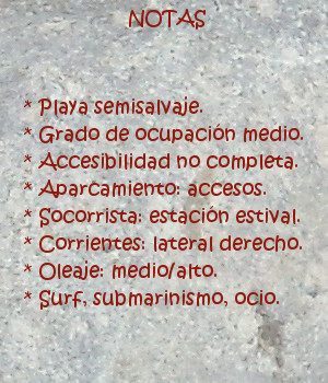
Algún tiempo después, regrese a la zona de confort; para descansar. La marea había subido ligeramente y el mar aumentó su tamaño, consumiendo las energías a mayor velocidad. La ocupación de gran parte de la playa de Langre por el mar prolongaba el recorrido de la olas e hizo aparecer nuevos trazados.

Próximo al centro de la playa, comenzando por el lado más cercano al acceso, nacía una ola de tamaño medio. Metro a metro, sobre el fondo arenoso, elevaba su altura; desplazando la figura hacia el lado opuesto. Otro colega, ya dispuesto en aquel punto, comenzó a remar con la llegada de una nueva serie. Cuando lo alcanzó la primer ola, superaba los dos metros. Dejó su tabla caer hasta la base, para girar y correr paralelo a la pared. Avanzó unos metros, mientras la altura del agua continuaba creciendo. La velocidad de su tabla le permitió superar la rotura, para finalizar en un claro que se abrió ante él. Otros surfers se acercaron a la zona. Guíe mi tabla hacia allí . Con ritmo pausado, pude contemplar como surfeaban. Por turnos, trazaban maniobras sobre el agua. Apuraban el camino, evitando el cierre en bloque con el que terminaba la ola.

La corriente me desplazó unas decenas de metros hacia a la orilla. Posicionado de forma oblicua respecto al camino de la ola, obtuve por azar una mejor perspectiva del recorrido. El volumen de agua que se repetía, sobrepasaba el metro y medio de altura. Continuaba su marcha, sin abrir sus posibilidades. En el otro extremo las condiciones eran más favorables. Seguía el mar en aquella zona, el dibujo curvo de la playa. Esto provocaba que la ola mostrará un rizo que se prolongaba más allá. El bloque de agua, que se desplomaba delante de mí, ocultaba los detalles que sucedían a lo lejos. Acerque mi tabla a una posición interior. Una nueva ola apareció a cincuenta metros. Remando lateralmente, me elevó, giré con rapidez para no ser arroyado. Cortando el agua en su mitad, obtuve un trazado limpio. Remontando a la cima, choque contra la cresta, recorriendo el camino inverso. Salí propulsado delante de la espuma, producida por la caía en barra del mazacote que se había formado. Buceé profundamente esquivando el remanente de energía. Atrás quedó la tabla, que tiró con violencia del tobillo, con la llegada de la viva espuma.

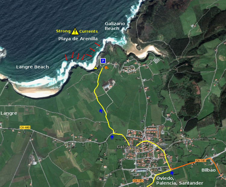
Dispuesto a evitar olas no practicables, fui avanzando en dirección al acantilado cercano a Galizano. Un grupo de iniciantes, acompañados por un monitor, trataba de superar la barrera que se formaba en la orilla. Ninguno de nosotros conseguía progresar. Esperé a que las olas me devolvieran a la playa. Desde la arena, caminé con la tabla recogida. Dejando atrás la zona central, encontré una puerta cómoda. Entré hasta ciento cincuenta metros. En el lateral del bloque central, aparecía un rizo. Aterrizando suavemente sobre el agua, después de un recorrido estable.

La playa se había vaciado parcialmente. En la nueva zona, la visión panorámica del entorno animaba a quedarse en el agua. Desde allí, las aventuras de otros colegas se iban sucediendo. El intento por surfear la activa e impredecible zona central suministraba trazados maestros y varias caídas. Una chica se alzó sobre la tabla, conteniendo la energía de la ola. Con un gesto que parecía torpe, redujo la velocidad que llevaba. Caminando a la base y girando con los pies, modificó la trayectoria. Tras unos metros, volvió a la cresta. Antes de llegar extendió los brazos. Su rastro quedó marcado sobre el agua, en forma de media luna. Cerca del final, saltó detrás de la ola; que la contacto lejana por medio de su tabla. Una amiga suya, tras verla asomar sobre la superficie, silbó con alegría. El resto de nosotros aplaudió tímidamente el viaje que vivió y plasmó.

Langre, discovering tha waves. Tour

English Some time later, I returned to the zone of comfort; to rest. The tide had risen lightly and the sea increased its size which consumed the efforts with more speed. The occupation of great part of Langre’s beach by the sea was prolonging the tour of the waves and made appear new tracings.

Near the center of the beach, beginning for the side nearest to the access, was born a wave of average size. Meter after meter, over the sandy bottom, it was adding its height; moving the figure towards the opposite side. Another colleague already arranged in that zone, began to resea with the arrival of a new series. When the first wave reached him, it was overcoming two meters. It left his board to fall down up to the bottom, to turn and to run parallel to the wall. He advanced a few meters, while the height of the water was growing. The speed of his board allowed him to overcome the break, to finish in the clear one that it was opened in front of him. Other surfers approached the zone. I guide the board towards there. With slow pace, I could meditate about their surfing. Through rounds, they were planning maneuvers on the water. They were getting the way until the end, avoiding the closing in block with the one that was finishing the wave.

The currents me displaced a few dozens of meters towards to the shore. Positioned of oblique form with regard to the way of the wave, I obtained for random a better perspective of the tour. The water volume that was repeating , was over one meter and a half of height. It was continuing its march, without opening its possibilities. At the far end the conditions were more favorable. It was following the sea that zone, the curved drawing of the beach. This was provoking that the wave would show a curl that was extending beyond. The water block, which was collapsing in front of me, was concealing the details that were happening in the distance. I brought my board over to an interior position. A new wave appeared to fifty meters. I rowed laterally, it arrived me, I turned with rapidity not to be arroyado. when I cut the water in its middle, I obtained a clean tracing. Going to the top, I hit against the comb, crossing the inverse way. I was shot in front of the foam, that was produced by the falling down in block of the bar that had been formed. I dived deeply avoiding the remnant of energy. Behind there, stayed the board, which threw with violence of the ankle, with the arrival of the alive foam.

Ready to avoid not practicable waves, I advanced towards the cliff near to Galizano. A group of beginners, accompanied by a monitor, was trying to overcome the barrier that was formed in the shore. None of us was managing to progress. I waited that the waves would return me to the beach. From the sand, I walked with the board. Leaving behind the central zone, I found a comfortable door. I entered up to hundred fifty meters. In the wings of the central block, a curl was appearing. It was landing softly on the water, after a stable tour.

The beach had been emptied partially. In the new zone, the panoramic vision of the environment was stimulating us to be in the water. From there, the adventures of other colleagues were happening. The efforts for surfing, the active and unpredictable central zone, was supplying master tracings and several falls. A girl raised on the board, as she reduced the energy of the wave. With a gesture that seemed to be awkward, she reduced the speed that was unuseful. She walked to the base and turning her feet, she modified the path. After a few meters, it returned to the top. Before it, she extended the arms. His track remained marked on the water, in the shape of half moon. Near the end, she jumped behind the wave; that contacted her distantly, through her board. A friend of her, after seeing that was on the surface, whistled with happiness. The rest of us applauded shyly the trip that lived and that was shown.
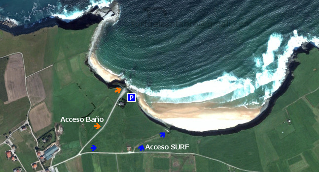
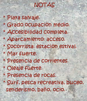
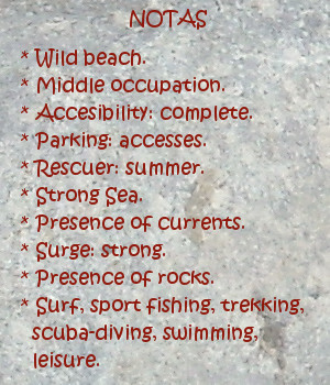
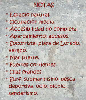
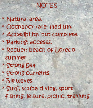
Icon close Sponsor

Share

Langre, descubriendo las olas. Comienzo

icono bandera España El fin de semana venía cargado de olas. Las predicciones de surf auguraban tamaños de uno a dos metros y medio a lo largo de toda la costa. El cambio de estación ya se había producido oficialmente y el verano, aún presente, estaba desplazando al otoño. Las buenas temperaturas y la calidez del agua llenaban las playas de trasiego. Con estas condiciones llegaba el mejor momento para la Playa de Langre.

Entrando en la localidad, coincidí con otros colegas que iban hacia la playa. Más adelante, la anchura de la carretera convertía la circulación en una hilera de vehículos; separados por una pequeña distancia y movidos al compás del paisaje. De fondo sonaba el eco del Mar hablando sobre la playa. La visión del aparcamiento trajo a mi memoria recuerdos felices de surf. Una suave brisa corría por el prado, moviendo la hierva a modo de ola. Había varios grupos de gente, con el equipo reposando, hablando de sus sesiones. Caravanas aparcadas, con un toldo extendido, se distribuían por toda la zona. Los transeúntes que llegaban desde de Galizano, Santa Marina y alrededores, se cruzaban en aquel punto. Algunos de ellos tomaban descanso en el balcón que da acceso a la playa grande de Langre. El día soleado permitía ver la línea azulada del horizonte sobre el acantilado. Asomado a dos metros del borde contemplé el estado del mar.

Series de cinco, seis olas se sucedían. Iban acompañadas de un rato de calma, tiempo suficiente para avanzar y recuperar fuerzas. Su tamaño rondaba los dos metros de altura, recorriendo una distancia media. Aparecían, a lo ancho de la playa, diferentes ondas con distintas formas y trazados. La naturaleza de cada una imponía adaptación e interpretación. Continué observando el espectáculo. Después de cinco minutos, varias personas terminaron la sesión. El agua despejada de gente llamaba al cambio de turno. Otro grupo bajaba a la arena. Con un ritmo atlético e impaciente, entraron al agua. A una pequeña parte del centro, llegaba una ola de gran envergadura que rompía en barra. La entrada por aquella zona se hacia por los costados, aprovechando el retroceso del agua. Otro compañero, situado a la izquierda, hacia señales con la mano; indicando un camino cómodo.

Un perro ladrando, con niños corriendo detrás de él, interrumpió el momento. Fui hasta el vehículo para coger el equipo. Preparando el material, iba pensando en las olas. Quería evitar cualquier imprudencia, pues la mar me había enseñado que conocer no es saber y que en este entorno; la calidad supera a la cantidad. Ya dispuesto, baje hasta la playa. Tras calentar y hacer estiramientos, entré al agua por el lateral de un pico de olas.

Remando con fuerza y haciendo la cuchara, conseguir superar la barrera inicial. Más adelante llegué a una zona tranquila. Hasta ella arribaban olas, con una altura adecuada para surfear. Continuaban su recorrido y aumentaban de tamaño para terminar rompiendo, a treinta metros de la orilla. Probé un par de ellas sin fuerza suficiente para deslizarme. Poco tiempo después, asomó una pared de agua de mayor altura. Al contacto con mi tabla, sentí la fuerza que transportaba. Sólo el impacto fue necesario para levantarme. Resbalando hasta la base, giré hacia la izquierda. Haciendo una maniobra de zig-zag , alcance la velocidad adecuada para maniobrar. Abrí el trazado a la derecha, regresé hacia la ola. Encontrados en su cresta, mi postura se congeló un instante sostenida sobre el agua, para volver a bajar. La onda se dirigía hacia el centro de la playa. Detrás de allí rompería en barra. Surfeando unos metros más pausados, afloraron todas las sensaciones. En dirección a la cima, con los brazos relajados y una sonrisa, acabé el viaje; saltando al otro lado.

Langre, discovering the waves. Beginning

English The weekend was going to arrive loaded of waves. The surf forecast had written sizes from one to two meters and a half along the whole coast. The change of season already had taken place officially, and the summer that was still present, was displacing the autumn. The good temperatures and the warmth of the water were filling the beaches of comings and goings . With these conditions the best moment was coming for Langre’s Beach.

Entering the locality, I coincided with other colleagues that were going towards the beach. Hereinafter, the width of the road was turning the traffic into a row of vehicles; separated by a small distance and moved the compass of the landscape. Of bottom, the echo of the sound of the Sea talking to the beach. The vision of the parking brought to my memory happy recollections of surf. A soft breeze was running for the meadow, moving it like a wave. There were several groups of people, with the equipment resting, and were speaking about the sessions. Parked caravans, with a sunshade, were by the whole zone. The transients who were coming from Galizano, Santa Marina and another places, were crossing through that area. Some of them took rest in the balcony that leads to Langre’s big beach. The sunny day was allowing to see the bluish line of the horizon over the cliff. I positioned out to two meters of the edge to contemplate the condition of the sea.

Series of five, six waves were happening. It was accompanied of awhile of calmness, sufficient time to advance and to recover forces. Its size was about two meters of height, crossing a medium distance. It was appearing, widthways of the beach, different waves with different forms and tracings. The nature of each one was imposing adjustment and interpretation. I continued observing the spectacle. After five minutes, several persons finished the journey. The free water of people was calling at the next shift. Another group was going down to the sand. With an athletic and impatient pace, they entered to the water. In a small part of the center, there was a wave of great importance that was breaking as a block. The entry for that zone was able through its sides, taking advantage of the setback of the water. Another companion placed to the left side, towards signs with the hand; indicating a comfortable path.

A dog that was barking, with children running behind it, interrupted the moment. I went up to the vehicle to take the equipment. When I set the elements, I began to think about the waves. I wanted to avoid any recklessness, since the sea had taught me that knowing is not to know and that in this environment; the quality overcomes to the quantity. When I was ready, I went down up to the beach. After warming and to do stretchings, I entered to the water through the sides of a beak of waves.

I rowed strongly and made the duck, I managed to overcome the initial barrier. Hereinafter I came to a calm zone. To that place the waves were arriving, with a height adapted for surfing. Them were continuing the tour and were increasing of size, to end up by breaking; to thirty meters of the shore. I proved a couple of them without sufficient force to play. A little time later, it put out a water wall of major height. At the contact with my board, I felt the power that it was transporting. Only the impact was necessary to get up. I slipped up to the base, I turned towards the left side. With a maneuver of zig-zag, scope the necessary speed to maneuver. I opened the tracing for the right, returned towards the wave. I met with the wave in its top, my position froze an instant supported on the water, to return to go down. The wave was going towards the center of the beach. Behind there, it would break in a block. I followed the way a few meters, all the sensations flowed. Towards the top, with the relaxed arms and a smile, I finished the trip; jumping to the other side.

Icon close Sponsor

Share