Olas, orígen y definición

Icono Español. Icon Spanish Las olas se forman por la efecto del viento sobre la superficie de las aguas. A diferencia de las mareas o las corrientes la formación de las olas es un movimiento irregular. La intensidad del viento determina la magnitud de las olas.

En una ola se distinguen las siguientes partes : la amplitud, que es la diferencia de nivel entre la parte más alta (cresta de la ola) y la más baja (valle); la longitud, que es la distancia horizontal entre dos crestas o dos valles sucesivos, y el período, que es un concepto temporal determinado por el tiempo entre el paso de dos crestas sucesivas por el mismo punto.

La amplitud (altura) y la longitud de la ola dependen de tres factores: la fuerza del viento, el tiempo de actividad de este y la distancia que la ola ha recorrido. Estas dos características de las olas están a su vez condicionadas por el mar en el que se producen, pues la profundidad del mar afecta a su altura y amplitud absorvíendo parte de la energía que la ola transporta y que se pierde al contacto con el fondo marino. Por ejemplo las olas en el Mar Mediterráneo no superan normalmente los 4 metros, sin embargo en la costa del Atlántico que baña España y Portugal las olas superan los 10 metros en condiciones normales y en ciertos puntos de la costa.

icono español-inglés vertical

Waves, origin and definition

Icono Inglés. Icon English The waves are formed by the effect of the wind on the surface of the water. Unlike the tides or currents wave formation is an irregular movement. The intensity of the wind determines the magnitude of the waves.

In a wave are distinguished the following parties: the amplitude, which is the difference in level between the top (crest of the wave) and the lowest (valley); the length, which is the horizontal distance between two crests or two successive valleys, and the period, which is a temporary concept determined by the time between the passage of two successive ridge by the same point.

The amplitude (height) and the length of the wave depends on three factors: the strength of the wind, the uptime of this and the distance that the wave has come. These two features of the waves are in turn influenced by the sea in which they are produced, because the depth of the sea affects its height and length taking part of the energy that the wave carries and that will be lost when meets with the seabed. For example the waves in the Mediterranean Sea not normally exceed 4 meters, however on the Atlantic coast that hits Spain and Portugal the waves exceeding 10 meters in normal conditions and in certain points on the coast.

Icon close Sponsor

Share

Langre, localización

Icono Español. Icon Spanish La playa está situada en el municipio del mismo nombre, que pertenece al Ayuntamiento de Ribamontán al Mar. Se puede llegar a la playa desde Oviedo, Palencia, Santander o desde Bilbao, ambos trayectos son por autovía finalizando el viaje por carretera nacional (único acceso). El trayecto finaliza en el municipio de Langre, el camino hasta la playa está bien indicado.

Langre, Localization

Icono Inglés. Icon English The beach is located in the locality of the same name, which belongs to the Municipality of Ribamontán al Mar. It is possible to come to the beach from Oviedo, Palencia, Santander or from Bilbao, both routes run through the highway to end the trip by national road (only access). The route finishes in the municipality of Langre, the way up to the beach is well indicated.

Icono Español-Inglés. Icon Spanish-English Localización/Localization

Oviedo-Langre: LocalizationPalencia-Langre: LocalizationBilbao-Langre: LocalizationSantander-Langre: Localization

Icon close Sponsor

Share

Berria, localización

Icono Español. Icon Spanish Esta especial playa se ubica en el municipio de Santoña. Es una playa que se encuentra en el istmo que une la península que forma el monte Buciero (en Santoña) con el municipio de Argoños. A través de la carretera CA-907 se accede finalmente a la playa, tanto desde Santoña como desde Argoños.

Berria Beach, Localization

Icono Inglés. Icon English Berria beach is located in the town of Santoña. It is a beach which is placed in the isthmus that connects the peninsula forming the Buciero Mount (in Santoña) with the municipality of Argoños. Through the national road CA-907 you can finally access to the beach, from Santoña or Argoños.

Icono Español-Inglés. Icon Spanish-English Localización/Localization

Oviedo,Berria-beach: LocalizationPalencia,Berria-beach: LocalizationBilbao,Berria-beach: LocalizationSantander,Berria-beach: Localization

Icon close Sponsor

Share

Berria beach, acceso

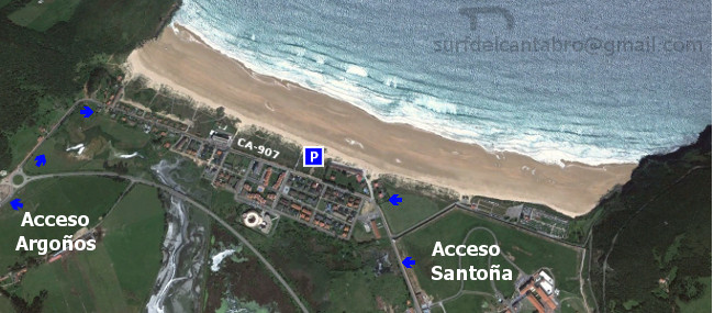
Icono Español. Icon Spanish. Berria beach La Playa de Berria tiene dos accesos por la carretera nacional CA-907. El acceso oeste proviene de la localidad de Argoños. El acceso este proviene de la localidad de Santoña.

Berria beach, access

Icono Inglés. Icon English. Berria beach Berria Beach has two entrances from the national road CA-907. The west access comes from the village of Argoños. The east access comes from the town of Santoña.

Icono Español-Inglés. Icon Spanish-English. Berria beach Acceso/Beach Access

Acceso Playa de Berria. Berria beach access

Icon close Sponsor

Share

Somo,localización

Icono Español. Icon Spanish Este municipio de la costa cántabra pertenece al Ayuntamiento de Ribamontán al Mar. Desde la localidad se accede a las siguientes playas: Somo y El Puntal. Se llega a la villa desde Oviedo, Palencia, Santander o Bilbao. Comenzando el viaje por autovía y finalizando el recorrido por carretera nacional en todos los trayectos.

Somo, localization

Icono Inglés. Icon English This town of the Cantabrian coast, belongs to the municipality of Ribamontán al Mar. From the locality you can access at the following beaches: Somo beach and «El Puntal». You can arrive to this village from Oviedo, Palencia, Santander or Bilbao. The beginning of the journey is done by highway, the end of the travel runs through a national road in all the pathways.

Icono Español-Inglés. Icon Spanish-English Localización/Localization

OviedoaSomo: LocalizationPalencia,Somo: LocalizationBilbao,Somo: LocalizationSantanderaSomo: Localization

Icon close Sponsor

Share

Somo, acceso. Playas

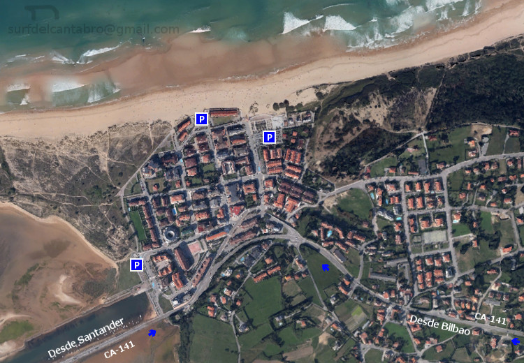
Icono. Icon Somo tiene varios accesos a sus playas, ya que dispone de un paseo marítimo y dos puntos de entrada a la localidad. Por el oeste desde Santander, pasando el Puente de Somo; que conecta Pedreña con Somo, por la carretera nacional CA-141. Por el este desde Bilbao, por la carretera nacional CA-141. Los dos accesos comparten la misma carretera nacional.

Somo, access. Beaches

Icono. Icon Somo has multiple accesses to its beaches, as it has a promenade and two entry points to the locality. The west way from Santander, crossing the Bridge of Somo; that connects Pedreña with Somo, through the national road CA-141. The east way from Bilbao, also ending the travel through the national road CA-141.

Icono español-inglés. Icon Spanish-English Acceso/Beach Access

Acceso Somo

Icon close Sponsor

Share

Loredo, acceso. Playas

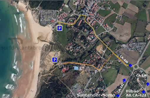
Icono. Icon. Loredo, acceso La playa de Loredo tiene dos accesos, ambos por la carretera nacional CA-440. El primer acceso nos sitúa en la mitad de la playa y se llega cogiendo la primera desviación, marcada en la imagen con color naranja. El segundo acceso nos lleva hasta el final de la playa de Loredo, y está marcada en la imagen con color amarillo y más extensa que la anterior.

Loredo, access. Beaches

Icono. Icon. Loredo, access The beach of Loredo has two entrances, both ways through the national road CA-440. The first access leaves you in the middle of the beach and can be reached by taking the first deviation, marked in the image with the orange line. The second access allows you to the end of the beach of Loredo, and is marked on the image with the yellow line and it is more extensive than the previous line.

Icono español-inglés. Icon Spanish-English. Loredo, acceso, access Acceso/Beach Access

Acceso playa de Loredo. Access to Loredo beach

Icon close Sponsor

Share

Loredo, localización

Icono Español. Icon Spanish La playa de Loredo está situada en la localidad del mismo nombre, perteneciente al municipio de Ribamontán al Mar; que se emplaza en la costa central de Cantabria. Se puede llegar a esta playa desde Oviedo, Palencia, Santander o Bilbao, finalizando todos los trayectos por la misma carretera nacional.

Loredo, Localization

Icono Inglés. Icon English The Loredo beach is placed in the locality of the same name, belonging to the municipality of Ribamontán al Mar; that is located in the central coast of Cantabria. It is possible to arrive to this beach from Oviedo, Palencia, Santander or Bilbao, finishing all the ways for the same national road.

Icono Español-Inglés. Icon Spanish-English Localización/Localization

Oviedo, Loredo: LocalizationPalencia, Loredo: LocalizationBilbao, Loredo: localizationSantander, Loredo: Localization

Icon close Sponsor

Share

Isla de Santa Marina. Un lugar tan especial como peligroso

Icono. Icon La Isla de Santa Marina, situada en el municipio de Loredo es un lugar ideal para realizar prácticamente cualquier deporte acuático. Son conocidas las grandes olas que azotan la isla en ciertos períodos del año lo que atrae a personas de todo el mundo para surfear olas que llegan a los 5 metros. El submarinismo también tiene en la isla su espacio, siendo una zona de mayor uso el canal que comunica la isla con el acantilado de Loredo. La pesca en esta zona es también otro disfrute. Sin embargo debido a todas las condiciones que la hacen ideal para el ocio también la convierten en un lugar de extremo peligro cuando la mar golpea a la Isla de Santa Marina con fuerza. Leer más … Icono. Icon

Separador. DividerIcono español-inglés. Icon Spanish-EnglishIcono. IconIcono separador. Icon divider

Santa Marina Island, a place as special as dangerous

Icono. Icon The Island of Santa Marina, placed in the municipality of Loredo, is an ideal place to realize practically all water sports. There are known the big waves that flog the island in certain periods of the year what attracts people all over the world for surfing waves that come to 5 meters. The diving also has in the island its space, being an area of major use the channel that communicates the island with the Loredo cliff. The fishing in this zone is also another enjoyment. Nevertheless due to all the conditions that make it ideal for free time also turn it into a place of extreme danger when the sea hits the Island of Santa Marina strongly. Read more … Icono. Icon

Icon close Sponsor

Share