Galizano, villa

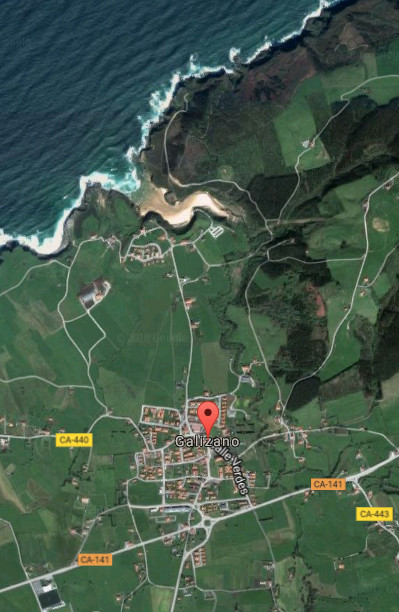
Icono Español. Icon Spanish. Galizano, villa village Galizano es una pequeña localidad emplazada en la costa central de Cantabria. Esta villa costera, perteneciente al municipio de Ribamontán al Mar, concentra su núcleo de población entorno a la Iglesia de Nuestra señora de la Asunción. Edificios blasonados y casas antiguas de piedra describe su pasado. El resto del territorio esta compuesto por tierras de siembra y fincas ganaderas.

La costa de Galizano, abrupta y salvaje, conserva su estado natural que sólo la meteorología ha condicionado con el paso del tiempo. Acantilados tallados con un lecho de rocas depositadas en su base predominan en la zona, siendo parcialmente visibles en marea baja. La playa de Arenilla, pequeña cala rodeada de acantilados, de apenas 200 metros de longitud que es cubierta con la marea alta condensa la riqueza geológica y paisajística de Galizano. La playa de Galizano, también conocida como La Canal, realiza el tránsito sobre fina arena que comunica el Arroyo Herrera con la parte acantilada que da la entrada del mar a la playa a través de un recorrido serpenteante. Los cañones contemplados desde el mirador que secunda a la playa abrirán una perspectiva de 360 grados , con un sendero a su derecha que permite hacer una hermosa ruta que da acceso a la Cueva de Cucabrera.

Galizano, village

Icono Inglés. Icon English. Galizano, villa, village Galizano is an small locality plaed in the central coast of Cantabria. This coastal villa, belonging to the municipality of Ribamontán al Mar, concentrates its center of population close to the Church Nuetra Señora de la Asuncion. Noble buildings and ancient houses of stone describes its past. The rest of the territory is composed by farm and pasture lands.

The coast of Galizano, abrupt and wild, preserves its natural condition that only the meteorology has determined with the passage of time. Cliffs carved with a bed of rocks deposited in the base prevail in the zone, being partially visible in low tide. The beach of Arenilla, an small cove surrounded with cliffs, with scarcely 200 meters of length that is covered with the high tide condenses Galizano’s geological and landscape wealth. The beach of Galizano, also known as La Canal, does the transition, over thin sand, that communicates the Herrera Stream with the steep part that gives the entry of the sea to the beach across a meandering tour. The cannons that are contemplated from the viewing-point that supports to the beach will open a perspective of 360 degrees, with a path to its right that allows to do a beautiful route that leads to the Cave of Cucabrera.

Galizano, villa. Icon text divider

Galizano villa, village. Ruta. Route

Icono español-inglés. Icon Spanish-English. Galizano, villa, village. Map Galizano, village

Galizano, villa

Galizano, villa. icon close cities

Share

Ajo, ciudad

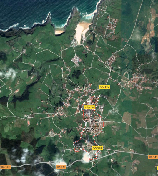
Icono Español. Icon Spanish. Noja, city Ajo es una localidad emplazada en la costa oriental de Cantabria. Capital del municipio de Bareyo y situando a 46 metros sobre el nivel del mar su núcleo urbano, con el cual convive a través de sus playas.

La villa cuenta con barrios parcialmente poblados, separados entre sí y diseminados a lo largo y ancho de su extenso terrotorio. El acceso núcleo central de población se puede realizar por varios puntos, este y oeste. La entrada principal desde la carretera nacional CA-141, por la carretera CA-446, descubre la zona más turística de la localidad. La Iglesia de San Martín de Tours y el Convento de San IldeFonso son algunos ejemplos de su histórico pasado. Continuando el viaje llegamos a las playas de Ajo: Antuerta y Cuberris. Su especial fisonomía, acorde a la zona, recoge el oleaje cantábrico y ofrece una infinidad de actividades de ocio. La proximidad de los arenales al Cabo de Ajo, apenas 3 kilómetros los separan, determina sus características.

La costa de Ajo supera los 10 kilómetros de longitud. Su forma irregular y abrupta alberga acantilados de gran belleza y singularidad. Cualquier punto de la línea costera dispone una perspectiva única sobre el mismo lienzo que allí presenta el Mar Cantábrico. Colores, sombras, y sonidos aderezan la contemplación del paisaje que en plena naturaleza trasmiten la idea de la ausencia del tiempo.

Ajo, city

Icono Inglés. Icon English. Noja, city Ajo is a locality sited in the oriental coast of Cantabria. It is capital of the municipality of Bareyo and placing to 46 meters on the level of the Sea its urban core which it coexists through its beaches.

The villa possesses neighborhoods that are partially populated , separated between them and spread lengthways and width of its extensive terrotory. The access to the central core of population can be realized by several points, East and West. The principal entry from the national road CA-141, through the road CA-446, discovers the most tourist zone of the locality. The Church of St Martin of Tours and San IldeFonso’s Convent are some examples of his historical past. Continuing the trip, we come to the beaches of Ajo: Antuerta and Cuberris. Its special physiognomy, chord to the zone, gathers the Cantabrian Sea surge and offers an infinity of activities of leisure. The proximity of the sandbanks to the Cape of Ajo, scarcely 3 kilometres separate them, determines its characteristics.

The coast of Ajo overcomes 10 kilometres of length. Its irregular and abrupt form is home to cliffs of great beauty and singularity. Any point of the coastal line arranges an unique perspective on the same canvas that presents the Cantabrian Sea. Colors, shades, and sounds cook the contemplation of the landscape that in full nature communicates the idea of the absence of the time.

Icon text divider

Ajo, route

Icono español-inglés. Icon Spanish-English. Ajo, city Noja, ciudad

Ajo, city

icon close cities

Share

Noja, ciudad

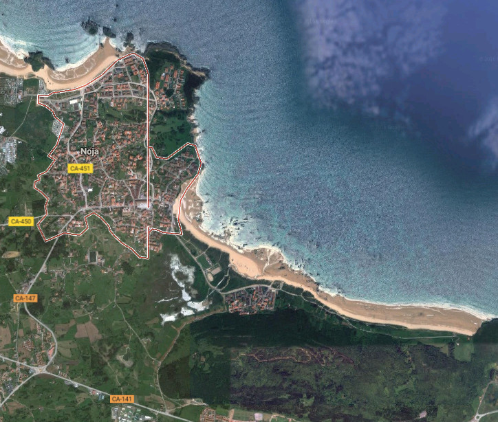
Icono Español. Icon Spanish. Noja, city Noja, singular municipio de la costa oriental de Cantabria, es una villa cuya organización se articula en barrios. Delimitado en el oeste por la Playa de los Barcos, en el este está acotada por el Monte EL Brusco, que da nombre a la playa que se sitúa en sus accesos.

Su costa rocosa e irregular supera los 15 kilómetros de longitud y cuenta con varios arenales de fina y blanca arena. Las playas de los Barcos, Ris, Trengandín y el Brusco ocupan el 70% de la línea de costa. Variedad ofrece al visitante un amplio abanico de opciones donde practicar el baño y disfrutar del descanso. El surf, la pesca, el submarinismo y demás deportes acuáticos pueden ser disfrutados en sus arenales. La orografía de la cara Este de la villa contiene la Ensenada de Noja. Las talladas rocas que pueblan la bahía asoman sus afiladas cimas sobre las aguas del Mar Cantábrico y proporcionan un espectáculo de belleza onírica con la marea baja.

Las Marismas De Victoria y Joyel, rodean el municipio y componen, junto con las Marismas de Santoña, el mayor humedal de la cornisa cantábrica. Ambos estuarios disponen de observatorios para aves y senderos que los rodean y/o atraviesan, ofreciendo distintas perspectivas del parque natural que forman. Estos tesoros que forman parte del patrimonio de Noja pueden anticipar la inmensidad de la zona que será descubierta con cada paso, en cada rincón.

Noja, city

Icono Inglés. Icon English. Noja, city Noja, singular municipality of the oriental coast of Cantabria, is a villa which organization is articulated in neighborhoods. Delimited in the west for the Beach of Los Barcos, in the East there is annotated by the Mount El Brusco, which gives name to the beach that places in its accesses.

Its rocky and irregular coast overcomes 15 kilometres of length and possesses several sandbanks of thin and white sand. The beaches of Los Barcos, Ris, Trengandín and El Brusco occupy 70 % of the line of coast. Variety that offers a widely range of options to the visitor where to practise the swimming and enjoy the relaxation. The Surf, the fishing, the scuba diving and other aquatic sports can be enjoyed in its sandbanks. The orography of the west face of the villa contains the Inlet of Noja. The chiseled rocks that populate the bay put its sharp tops over the waters of the Cantabrian Sea and provide a spectacle of oneiric beauty in the low tide.

The Marshes of Victoria and Joyel, surround the municipality and compose, with Santoña’s Marshes, the major wetland of the Cantabrian cornice. Both estuaries have observatories for birds and paths that surround and / or cross them, offering different perspectives of the nature reserve that form. These exchequers that form a part of Noja’s heritage can anticipate the immensity of the zone that will be discovered by every step, in every corner.

Icon text divider

Noja, city. Route

Icono español-inglés. Icon Spanish-English. Noja, city Noja, ciudad

Noja, City

icon close cities

Share

Santoña, ciudad

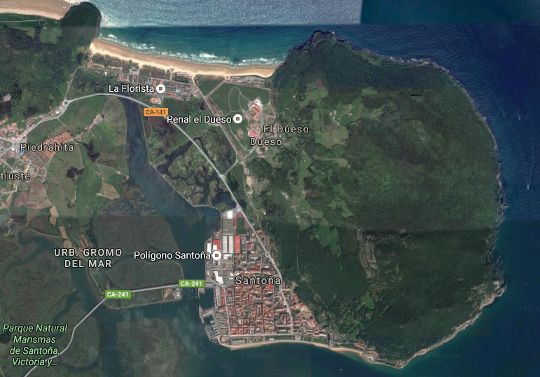
Icono Español. Icon Spanish Santoña, municipio de la costa oriental de Cantabria, es una pequeña y especial ciudad marinera asentada a los pies de la cara suroeste del Monte Buciero. El 95% de su perímetro está rodeado por agua. Limitando al norte, sur y este con el Mar Cantábrico. En la cara oeste se encuentra las Marismas de Santoña, Victoria y Joyel, Parque Natural cuya extensión supera las 6000 hectáreas. El inmenso área que ocupan las marismas configura el interior del municipio hasta alcanzar la playa de Berria, situada al noroeste. La playa de San Martin, emplazada en la bahía, abarca una gran parte del paseo marítimo de la villa; conocido como El Pasaje.

El Puerto Deportivo dispone en sus cercanías de un Centro de Interpretación del Parque Natural de las Marismas de Santoña. El Puerto Pesquero, anexo al centro de visitantes, delimita con el puente inicia la carretera que atraviesa las marismas y comunica la ciudad por el oeste. Esta carretera nacional es conocida como la «Carretera de los Puentes» y, además de prestar el propio servicio, da acceso al Observatorio de Aves de la Arenilla, el Monte Montehano y otras partes del estuario como la Ría de Argoños. Son sus puertos que miran a la Bahía de Santoña el principio del camino hacia el Mar Cantábrico.

Santoña, city

Icono Inglés. Icon English Santoña, municipality of the oriental coast of Cantabria, is an small and special maritime city seated to the feet of the southwest face of the Buciero Mount. The 95 % of its perimeter is surrounded by water. Bordering to the north, south and east with the Cantabrian Sea. In the west is The Marshland of Victoria and Joyel, Nature reserve which extension overcomes 6000 hectares. The immense area, that the marshes occupy, forms and builds the interior of the municipality up to reaching Berria’s beach, placed to the northwest. San Martin beach, located in the bay, includes a great part of the maritime walk of the villa; acquaintance as El Pasaje.

The Sport marina has, in its surroundings, a Center of Interpretation of the Nature reserve of Santoña’s Marshes. The Fishing port, attached to the visitors’ center, delimits with the bridge that initiates the road which crosses the marshes and communicates the city through the west. This national road is known as the «Road of the Bridges» and, in addiction to giving its own service, leads to the Observatory of Birds of La Arenilla, the Mount Montehano and other parts of the estuary like the Rivermouth of Argoños. They are its ports, that meet and greet with the Bay of Santoña, the beginning of the way at the Cantabrian Sea.

Icon text divider

Santoña, route

Icono español-inglés. Icon Spanish-English. Santoña, city Santoña, ciudad

Santoña, city

icon close cities

Share

Laredo, ciudad

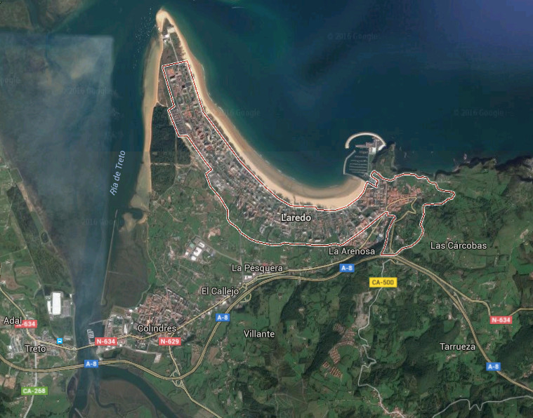
Icono Español. Icon Spanish Laredo, ciudad y municipio de la costa oriental cántabra, cuenta con una población estacional que supera los 12.000 habitantes. Esta población multiplica por diez su número para convertirse en uno de los destinos de mayor ocupación de Cantabria.

El caso antiguo de la villa hunde sus orígenes en el tiempo con los primeros pueblos que poblaron la zona y es en el siglo VIII cuando aparece la primer referencia escrita. Destacan sus monumentos, historia, su oferta turística y gastronómica. La Batalla de las Flores, fiesta declarada de interés turístico nacional, se celebra el último viernes de Agosto y constituye una expresión folclórica donde sus vecinos expresan su arte por medio de carrozas florales.

La configuración de la ciudad descansa sobre montes y montañas, para extenderse hasta el mar cubriendo la zona y poblando una punta de arena gigantesca cuyos arenales superan los 8 kilómetros de longitud. El nuevo puerto deportivo acota el arenal en su margen derecho. El Puntal, acota la villa en su extremo occidental que delimita con la de Ría de Treto.

Laredo, city

Icono Inglés. Icon English Laredo, city and municipality of the oriental coast of Cantabria, possesses a population that overcomes 12.000 inhabitants. This population multiplies by ten its number to turn it into one of the destinations of major occupation of Cantabria.

The historic center of the villa sinks its origins in the time with the first peoples that populated the zone and is in the 8th century when the first written reference appears. Stand out the monuments, history, its tourist and gastronomic offer. The Battle of the Flowers, a holiday that have been declared of tourist national interest, is celebrated the last Friday of August and constitutes an expression folclórica where the neighbors express his art by means of floral floats.

The configuration of the city rests on mounts and mountains, to spread up to the Sea covering the zone and populating a gigantic tip of sand which sandbanks overcome 8 kilometres of length. The new sports port annotates the sandbank in its right margin. The Puntal, a strut zone, annotates the villa in its western end that it delimits with the Estuary of Treto.

Icon text divider

Laredo,  route

Icono español-inglés. Icon Spanish-English. Laredo Laredo, ciudad


Laredo, Ciudad

icon close cities

Share

Castro Urdiales, ciudad

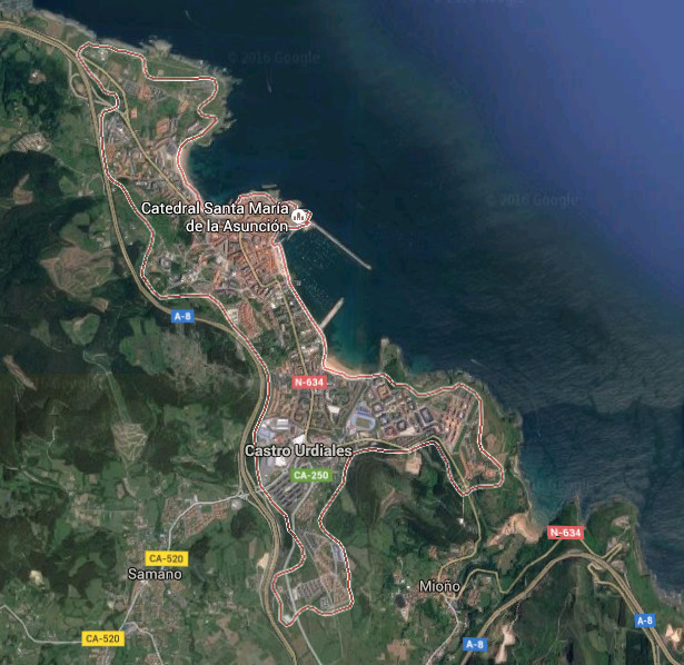
Icono Español. Icon Spanish Castro Urdiales es la ciudad más oriental de Cantabria y el municipio con mayor número de kilómetros de litoral. En sus casi 20 kilómetros de costa podemos encontrar pequeños cabos, ensenadas, islas, playas, el Estuario de Oriñón, y numerosas formaciones geológicas de gran belleza. La población de la ciudad, superior a los 30.000 habitantes, la sitúan como noveno municipio cántabro. Dispone de todos los servicios y cuenta con una amplia oferta turística y gastronómica. Destaca el Paseo Marítimo que avanza sobre la mitad de la línea de costa de Castro Uridales, atravesando las playa y el puerto.

Es, la llegada a la ciudad, un instante nuevo que va descubriendo las particularidades de la villa. La proximidad del mar y la montaña, la orografía de la zona y su fisonomía describen detalles de su historia y carácter. El transito sereno por el casco viejo descubrirá rincones y momentos congelados en el tiempo. Las cuestas, el adoquinado, los edificios de piedra que albergan locales decorados y cimentados con madera son algunos de los detalles que podemos encontrar.

Castro Urdiales, city

Icono Inglés. Icon English Castro Urdiales is the most oriental city of Cantabria and the municipality with major number of kilometres of littoral. In its almost 20 kilometres of coast, we can find small capes, inlets, islands, beaches, Oriñón’s Estuary, and numerous geological formations of great beauty. The population of the city, superior to 30.000 inhabitants, place it as the nine city of Cantabria. It has all the services and possesses a wide tourist and gastronomic offer. Stands out the Maritime Promenade that advances on the half of the line of Castro Uridales’s coast, crossing the beaches and the port.

It is, the arrival to the city, a new instant that is going to discover the particularities of the villa. The proximity of the sea and the mountain, the orography of the zone and its physiognomy describe details of its history and character. The serene traffic for the historic center will show corners and moments frozen in the time. The slopes, the paved one, the buildings of stone that shelter places that are decorated and established with wood are some of the details that we can find.

Icon text divider

Castro Urdiales, route

Icono español-inglés. Icon Spanish-English. Castro Urdiales, city Castro Urdiales, ciudad


Castro Urdiales

icon close cities

Share

Mercado de la Esperanza

Icono Español. Icon Spanish Situada detrás del ayuntamiento, con presencia habitual de viandantes y vehículos que transitan su contorno acotado por carreteras hábiles, está el Mercado de la Esperanza. Al cobijo del singular edifico de piedra y metal que contiene los comercios habita una pequeña plaza ocupada por las mañanas con puestos ambulantes, prolongación del mercado. Varios días a la semana las calles aledañas son invadidas por otros puestos de flores, plantas, cuadros y menaje del hogar.

Un paso tras otro conducían a Pedro hacia la plaza. Acompañado por su madre, la ciudad no parecía tan grande desde sus 7 años. Una amalgama de personas, productos y tenderetes ocultaba las baldosas de la calle Los Escalantes. El bullicio matutino cruzaba conversaciones privadas con proveedores y profesionales que anunciaban su producto entre chascarrillos, sonrisas y la mirada curiosa de un niño. Marta agarro a su hijo con fuerza y le dijo «no te separes de mí y no toques nada». Caminando a paso ligero se dirigieron a la entrada.

El Sol que iluminaba la calle, lucia el edificio de piedra y la cristalera de la segunda planta disparaba fugaces reflejos del astro. La entrada a la plaza sustituyó la luz natural por la luz filtrante de los focos del interior. La atmósfera estaba teñida de colores y formas sombreadas que ambientaban el lugar. Las pescaderas ordenaban el producto, limpiaban los peces e iban atendiendo a los clientes. Cabrachos rojizos y de peculiar aspecto completaban el muestrario de sardinas, salmonetes y bocartes que tenia el puesto número dos a la entrada del recinto. Marta cruzaba con andar sereno hacia su puesto de confianza, ojeando la mercancía. Los ojos del niño alumbraban allá donde la madre mirase…

Hope Market

Icono Inglés. Icon English Placed behind the town hall, with habitual presence of pedestrian and vehicles that circulate its contour annotated by skilful roads, is the Market of the Hope. To the shelter of the singular building of stone and metal that contains the stalls there is an small square occupied in the mornings with ambulant shops, prolongation of the market. Several days a week the bordering streets are invaded by other flower stands, plants, pictures and furniture of the home.

One step after other were leading Pedro towards the marketplace. Accompanied by his mother, the city did not seem to be so big from his 7 years. An amalgam of persons, products and stands was concealing the tiles of the street Los Escalantes. The morning hustle was crossing private conversations with suppliers and professionals who were announcing the product between funny stories, smiles and the curious look of a child. Marta strongly caught his son and said to him «you do not separate of me and do not touch anything «. Walking quickly they went at the entry.

The Sun that was illuminating the street, shined the building of stone and the windows of the second floor was shooting fleeting reflections of the star. The entry to the square replaced the natural light with the filtering light of the lightbulbs that were inside. The atmosphere was dyed of colors and shaded forms that were setting the place. The fishmongers were arranging the product, cleaning the fish and attending to the clients. Reddish scorpion fishes with peculiar aspect were completing the sample of sardines, red mullets and anchovies that had the stand number two at the entry of the enclosure. Marta was crossing, serenely towards his stall of confidence, and seeing the goods. The eyes of the child were lighting there where the mother was looking…

Icon Local Experience

Share