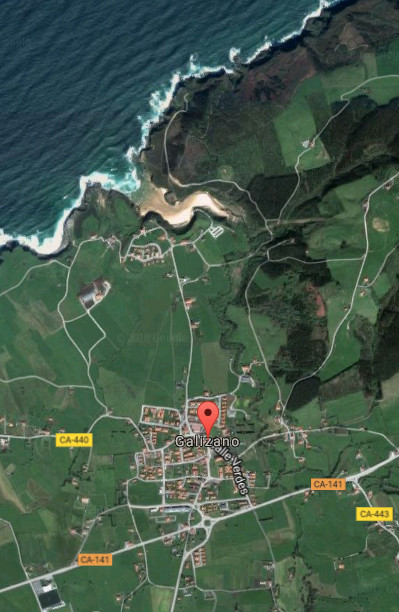
Galizano, villa

Icono Español. Icon Spanish. Galizano, villa village Galizano es una pequeña localidad emplazada en la costa central de Cantabria. Esta villa costera, perteneciente al municipio de Ribamontán al Mar, concentra su núcleo de población entorno a la Iglesia de Nuestra señora de la Asunción. Edificios blasonados y casas antiguas de piedra describe su pasado. El resto del territorio esta compuesto por tierras de siembra y fincas ganaderas.

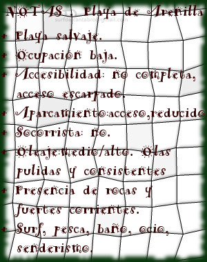
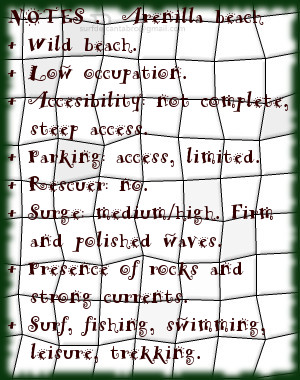
La costa de Galizano, abrupta y salvaje, conserva su estado natural que sólo la meteorología ha condicionado con el paso del tiempo. Acantilados tallados con un lecho de rocas depositadas en su base predominan en la zona, siendo parcialmente visibles en marea baja. La playa de Arenilla, pequeña cala rodeada de acantilados, de apenas 200 metros de longitud que es cubierta con la marea alta condensa la riqueza geológica y paisajística de Galizano. La playa de Galizano, también conocida como La Canal, realiza el tránsito sobre fina arena que comunica el Arroyo Herrera con la parte acantilada que da la entrada del mar a la playa a través de un recorrido serpenteante. Los cañones contemplados desde el mirador que secunda a la playa abrirán una perspectiva de 360 grados , con un sendero a su derecha que permite hacer una hermosa ruta que da acceso a la Cueva de Cucabrera.

Galizano, village

Icono Inglés. Icon English. Galizano, villa, village Galizano is an small locality plaed in the central coast of Cantabria. This coastal villa, belonging to the municipality of Ribamontán al Mar, concentrates its center of population close to the Church Nuetra Señora de la Asuncion. Noble buildings and ancient houses of stone describes its past. The rest of the territory is composed by farm and pasture lands.

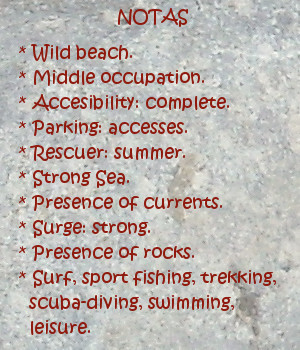
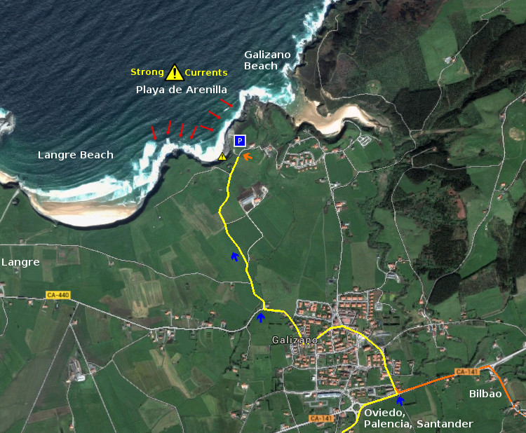
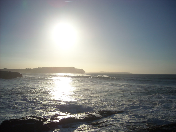
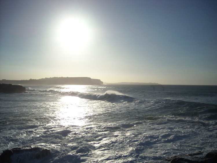
The coast of Galizano, abrupt and wild, preserves its natural condition that only the meteorology has determined with the passage of time. Cliffs carved with a bed of rocks deposited in the base prevail in the zone, being partially visible in low tide. The beach of Arenilla, an small cove surrounded with cliffs, with scarcely 200 meters of length that is covered with the high tide condenses Galizano’s geological and landscape wealth. The beach of Galizano, also known as La Canal, does the transition, over thin sand, that communicates the Herrera Stream with the steep part that gives the entry of the sea to the beach across a meandering tour. The cannons that are contemplated from the viewing-point that supports to the beach will open a perspective of 360 degrees, with a path to its right that allows to do a beautiful route that leads to the Cave of Cucabrera.

Galizano, villa. Icon text divider

Galizano villa, village. Ruta. Route

Icono español-inglés. Icon Spanish-English. Galizano, villa, village. Map Galizano, village

Galizano, villa

Galizano, villa. icon close cities

Share

Playa de Arenilla. Galizano

Icono Español. Icon Spanish. Playa Arenilla. Galizano La Playa de Arenilla está situada en la localidad de Galizano, perteneciente al municipio de Ribamontán al Mar. Emplazada en la costa central de Cantabria se ubica entre las playas de Langre y Galizano. Es una pequeña cala que apenas supera los 100 metros de longitud, su anchura en bajamar es de 50 metros y queda totalmente cubierta con la marea alta.

Arenilla en su mitad contigua al mar se compone de arenilla gruesa, con cuerpo, al contacto con el pie se mastican las pisadas. Su otra mitad, situada bajo el acantilado y con forma de U, está repleta de rocas apiladas, rozadas por el mar, que permiten sobre ellas un andar hábil. La parte derecha y superior del acantilado abre un sendero improvisado entre las rocas que llega hasta la playa de Galizano. El lado izquierdo y superior se comunica con la playa de Langre por medio de un camino agrícola. Su difícil localización y pedregoso acceso dan muestra de la naturaleza salvaje de la cala.

Las alas rocosas del acantilado amontonan rocas sueltas en su base, decorando su entrada al agua. La corriente fuerte exige buena condición física y la atención para evitar los laterales, con una pared frontal de roca estratificada en un lado y en el otro las corrientes circulares de la playa contigua; Langre. El frontal, situado en dirección decreciente hacia la cala, recibe una ola de derechas solo apta para surfers experimentados. La parte central, con su base profunda de roca y cubierta por gruesa arena metros por encima, crea una ola pulida, que abre a ambos lados y a veces solapa una ola de izquierdas tornando esta misma en derechas. De buena potencia y altura, traslada el agua limpia y con el ritmo adecuado para convertir la navegación en toda una experiencia que pueda reflejar por un instante la autenticidad del Mar Cantábrico y su costa.

Cabecera Cities Place Beaches. Playa de Arenilla. Galizano
Playa de Arenilla. Galizano , notas

Arenilla beach. Galizano

Icono Inglés. Icon English. Arenilla beach. Galizano The Beach of Arenilla is placed in the locality of Galizano, belonging to the municipality of Ribamontán al Mar. Located on the central coast of Cantabria it is situated between the beaches of Langre and Galizano. It is an small cove that scarcely overcomes 100 meters of length, its width in low tide is 50 meters and remains totally covered with the high tide.

Arenila in its half contiguous to the Sea consists of thick sand, bodied, to the contact with the foot the steps are chewed. Its another half, placed under the cliff and with form of U, is replete with rocks piled up, rubbed by the sea, which allow on them one who walks skilfully. The right and top part of the cliff opens an improvised path between the rocks that comes up to Galizano’s beach. The left and top side communicates with Langre’s beach through an agricultural way. Its difficult location and stony access give sample of the wild nature of the cove.

The rocky wings of the cliff accumulate free rocks in their base, decorating its entry to the water. The strong currents demand good physical condition and the attention to avoid the wings, with a frontal wall of rock stratified in a side and in other one the circular currents of the contiguous beach; Langre. The frontal, placed in diminishing direction towards the cove, receives a right wave only suitable for experienced surfers. The central part, with its deep base of rock and covered by thick sand meters, creates a polished wave, which opens to both sides and, sometimes it overlaps a left wave turning itself into a right wave. Of good power and height, it moves the clean water and with the pace adapted to turn the navigation into the whole experience that could reflect for an instant the genuineness of the Cantabrian Sea and its coast.

Cabecera Cities Place Beaches. Arenilla beach. Galizano
Arenilla, notes

Share

Galizano, playa

Icono Español. Icon Spanish. Galizano beach Galizano es una localidad cántabra, perteneciente al municipio de Ribamontán al Mar. Situado junto a la Ría la Canal, desembocadura del río Herrera, esta configuración ha formado la playa de Galizano, también llamada de San Miguel o de la Canal.

Los acantilados que presenta la costa de Galizano tienen vegetación abundante y fondo marino rocoso. El fuerte oleaje que llega a la zona convierte la practica del surf en una actividad sólo recomendada para surfers experimentados. La longitud de la playa es de 150 metros. Su irregular y original forma, dibujada por la ría que traza el camino del arenal entre los acantilados que la rodean hasta alcanzar el mar, tiene una anchura media de 100 metros, que en bajamar permite el acceso a pequeñas calas.

Es su entorno salvaje propicio para realizar rutas de senderismo que se extienden hasta Langre; hacia el oeste y Ajo; hacia el este. El trayecto transcurrirá repleto de estímulos. Acantilados verticales y estratificados, golpeados en su base por el mar, hablan de la historia del tiempo escrita su piel. Montes y montañas, cuevas, arrecifes rocosos,… hacen de la pesca recreativa y el buceo actividades completas, regalando en cada ocasión una nueva experiencia.

comic, mountain
Galizano playa, notas

Galizano, beach

Icono Inglés. Icon English. Galizano playa Galizano is a Cantabrian locality, belonging to the municipality of Ribamontán al Mar. Placed next to the rivermouth La Canal, which is the end of the river Herrera, this configuration has formed Galizano’s beach, also call San Miguel or La Canal.

The cliffs that Galizano’s coast presents have abundant vegetation and rocky sea bottom. The strong surge that comes to the zone turns the practice of the surf into an activity only recommended for surfers experienced. The length of the beach is 150 meters. Its irregular and original form, drawn by the rivermouth that plans the way of the sandbank between the cliffs that surround it up to reaching the sea, it has an average width of 100 meters, which in low tide allows the access to small coves.

It is its wild environment, propitious to realize trekking routes that spread up to Langre; towards the west and Ajo; eastward. The journey will pass replete with stimuli. Cliffs vertical and stratified , struck in its base for the sea that speak about the history of the time written in its skin. Mounts and mountains, caves, rocky reefs… that do of the recreative fishing and the scuba-diving; complete activities, giving in every occasion a new experience.

comic, mountain
Galizano beach, notes

Share

Playa de Arenilla, acceso

Icono Español. Icon Spanish La Playa de Arenilla está en Galizano. Situada entre la playas de Langre y Galizano, es una pequeña cala con un acceso escarpado. Tiene una ancha y pedregosa entrada utilizada a modo de aparcamiento. El fondo de roca, los acantilados y las fuertes corrientes; presentes en la zona la convierten en un lugar peligroso. Las rutas que llegan e la zona provienen del oeste ( Oviedo, Palencia, Santander ) y del este ( Bilbao ) deben atravesar la localidad de Galizano, cruzar el Barrio de Pedrosa y dirigirse hacia la costa en el primer cruce que aparece. Después la misma carretera nos conduce a la entrada de la Playa de Arenilla.

Beach of Arenilla, access

Icono. Icon The Beach of Arenilla is located in Galizano. Placed between the beaches of Langre and Galizano, it is a small cove with a craggy access. It has a broad and stony entry used like parking. The rocky bottom, the cliffs and the strong currents; presents in the zone turn her into a dangerous place. The routes that come from the west (Oviedo, Palencia, Santander) and from the east (Bilbao) must cross Galizano’s locality, through the Neighborhood of Pedrosa, to go towards the coast in the first crossing that appears. Later, the same road, leads us at the entrance of the Beach of Arenilla.

Icono Español-Inglés. Icon Spanish-English Acceso/Access

Access: Playa de Arenilla, acceso

Icon close Sponsor

Icon close Sponsor

Share

Playa de Arenilla, localización

Icono Español. Icon Spanish La Playa de Arenilla se encuentra en la localidad de Galizano, que pertenece al municipio de Ribamontán al Mar. Su localización no aparece en las guías oficiales, además la abundancia de caminos que dan acceso a las fincas de siembra de la zona, complican la situación de este punto. La playa es una pequeña cala de difícil acceso y rodeada por acantilados sobre mar abierta. Apta para el baño con precaución y la practica del surf, pues tiene fuertes corrientes y puede ser peligrosa. El viaje se hace por autovía y finaliza por carretera nacional y comarcal. Una vez situados en Galizano iremos hacia el Barrio de Pedrosa. Dejado atrás el barrio,tomamos el primer desvío a la derecha. Seguimos la carretera recta, sin coger ningún desvío más. Un kilometro después, veremos la cala, con un pequeño y pedregoso aparcamiento a su entrada. A continuación se muestra como puntos de partida: Oviedo, Palencia, Santander y Bilbao. Cualquier otro origen atraviesa uno de estos puntos.

Beach of Arenilla, Localization

Icono. Icon The Beach of Arenilla is placed in the locality of Galizano, that belongs to the municipality of Ribamontan al Mar. Its location does not appear in the official guides. In addition the abundance of roads that lead to the farm lands of the zone, it complicate the situation of this point. The beach is a small cove of difficult access and surrounded by cliffs and rocks on opened sea. Suitable for the bath with precaution and the practice of the surf, due to it has current forts and can be dangerous. The trip is done by highway and finishes by road nationally and regionally. Once placed in Galizano iremos towards the Neighborhood of Pedrosa. Leaving behind the neighborhood, we take the first detour to the right. We follow the straight road, without taking any other detour. A kilometre later, we will see the cove, with a small and stony parking at its entry. Shown below as starting points: Oviedo, Palencia, Santander and Bilbao. Any other origin crosses some of these points.

Icono Español-Inglés. Icon Spanish-English Localización/Localization

Oviedo, Playa de Arenilla:  LocalizationPalencia, Playa de Arenilla: localizationBilbao, Playa de Arenilla: localizationSantander, Playa de Arenilla: localization

Icon close Sponsor

Share

Buenas olas en marea baja. III

Icono Español. Icon Spanish La arena suelta descansaba sobre el fondo local, compuesto de rocas y arena firme. Estas características se reflejan directamente en la ola. Su trayecto es regular a lo largo de todo el recorrido. La superficie lisa facilita el deslizamiento, trasladando más velocidad a la tabla. Todas estas características proporcionan buenas olas y poder realizar maniobras.

Después de un rato hablando de la zona y sus olas, apareció a lo lejos una nueva serie. Su tamaño y la distancia hacían intuir buenos momentos de surf. La gente que aún quedábamos en el agua, nos fuimos dispersando a lo ancho. Con espacio suficiente entre nosotros, la elección de la ola y el trazado, iban a ser de mejor calidad. Un excitante nerviosismo llenaba el ambiente. La calma nos sobrevino un instante después. La idea de una gran ola anidaba en el pensamiento.

El hombre mayor se posicionó a la izquierda. Con la llegada de la primer ola se dirigió a su encuentro. Todo el mundo empezó a moverse hacia mar adentro. Remé con fuerza para alcanzar la mejor posición. Iba viendo como se acercaba aquella ola, su trazado semicurvo ocultaba parte de su extremo. Comenzó a romper por esa zona. Una silueta asomó en el recorrido de la ola. Cuando llegó hasta mí, me elevó. Giré para contemplar lo que sucedía. Con el agua lisa y esculpida, el surfer se fue desplazando; mirando hacia la ola. Así como la ola se fue alejando, él continuó su viaje.

La serie continuó. Colocado en posición, esperé la siguiente ola. Con dos metros de altura, mantenía su volumen sin romper. Cuando llegó hasta mi, golpeó la tabla y apenas tuve que remar. La sacudida me subió a ella. Abriendo hacia izquierdas, permanecí en la cresta durante unos metros. El extremo izquierdo venía cerrando. Cabalgué en lo alto. Antes de encontrarme con la rotura, giré con el cuerpo para volver sobre el trazado y no chocar con el cierre. Un nuevo camino se abrió. Bajé la ola y me dirigí hacia la derecha.Una sensación de vértigo y alegría me emborracharon. Balanceando los brazos conseguí regresar a la cima. Al contacto con esta flexioné el cuerpo y volví a girar. Un tramo recto y sencillo llegó a continuación. La adrenalina y la pasión fueron posando. Extendí los brazos y grité, consciente de la buena ola que había disfrutado. Con el viaje ya cercano a su final, las rocas se iban acercando. Me apeé de la ola zambulléndome en el agua. Buceando y soñando.

Icono Inglés. Icon English The loose sand had been rested on the local fund, composed of rocks and firm sand. These characteristics were reflected directly in the wave. Its design was regulate along the route. The smooth surface facilitated the slip, giving speed to the table. All these features provide good waves and the posibility to perform maneuvers.

After talking about the area and its waves for a moment, appeared in the distance a new series. Its size and the distance could announce good moments of surfing. People who still was in the water had got disperse points along the sea. With sufficient space between us, the choice of the wave and the path would have better quality. A exciting nervousness filled the atmosphere. Then a time of calm. The idea of a great wave was living in the thought.

The older man was positioned to the left. With the arrival of the first wave went to his meeting. Everybody began to move toward sea. I rowed with force to achieve the best point. I was watching as the wave was approaching , its layout drew a curve that had concealed part of its end. It began to break in that place. A silhouette appeared in the path of the wave. When it came up to me, I raised with the water . I turned to contemplate what was happening. With the smooth and sculpted water, the surfer was moving; facing the wave. As well as the wave was moving away, he continued his journey.

The series continued. I placed in position, waiting for the next wave. With two meters of height, it maintained its volume without breaking. When the wave came up to me, it hit the board and I barely had to row. The jolt transported me to the wave. The opening was toward left, I stayed at the crest for a few meters. The left end was closing. I continued riding the top. Before I met the breakage, I turned with the body to come back on the initial path and to avoid the closure. A new road was opened. I slid down the wave through to the right side. A sense of dizziness and joy accompanied me. Moving my arms I got back to the pinnacle. In contact with it, I bent the body and returned to rotate. A straight stretch and simple reached below. The adrenaline and the passion were posing. I stretched out my arms and shouted, aware of the good wave that I had enjoyed. With the trip close to its end, the rocks were approaching. I got off the wave, through the deep of the water. Diving, dreaming.

Icon close Sponsor

Share

Buenas olas en marea baja. II

Icono Español. Icon Spanish La carretera se prolongaba en una recta sobre una ligera cuesta. Al fondo se doblaba a la derecha y allí se divisaban vehículos aparcados. Las vacas pastaban en los campos cercanos a la entrada. Un camino pedregoso a modo de parking conducía a la entrada. En el agua, varios surfers cogían olas, dibujando sus maniobras sobre el agua.

La marea alta llegaría dentro de tres horas y media. La salida se iba a cerrar en menos de la mitad de ese tiempo. Todo el mundo se apeó del vehículo, nos pusimos a preparar el material y colocarnos los trajes. El descenso hasta el agua fue complicado. Rasa mareal y rocas sueltas ocupaban la cala. El suelo estaba punteado y erosionado por el mar dificultando el acceso hasta el agua. Con unas sandalias el camino se hizo practicable. Una vez cerca del agua colocamos el calzado en una roca alta, nos pusimos los escarpines y empezamos a entrar.

Avanzados apenas unos metros, la pisada se hundía en la arena. La base de firme irregular y aleatorio hacia elegir bien cada paso. La arena del fondo estaba suelta y el efecto de la corriente nos hacia tambalear. Unas olas bien definidas asomaban detrás de la rompiente. Las olas empujaban hacia las rocas y las corrientes nos mecían lateralmente como a juncos. Con el agua por encima de la cintura me subí en la tabla y empecé a remar. Las condiciones se iban mostrando cada vez más duras. Tras un tiempo largo, conseguí atravesar la entrada y llegar a una zona de relativa tranquilidad. A cien metros de la orilla, veíamos nacer las olas a media distancia. Su tamaño era de medio metro. Su ondulación definida se desplazaba de izquierda a derecha, ocupando la línea de costa que contenía a la cala. Cuando las olas alcanzaban nuestra posición, se elevaban ya sobre metro y medio.

Con el agua limpia y las olas moviendo un muro casi vertical de agua, se dibujaba sobre la superficie una trayecto alargado. Su forma de tobogán asimétrico seducía los ojos que lo contemplaban. La impaciencia me hizo elegir un par de olas no óptimas. Volver a entrar fue complicado. Las fuerzas se iban consumiendo. De nuevo en la zona del fondo, descansé para recuperar el esfuerzo. Allí había dos surfers locales hablando de la ola. Saludé y espere a que llegase otra ola. El de mayor edad de ellos me comentó que no debía coger cualquier ola, sólo las adecuadas, pues a todos nos costaba entrar, y que en la Playa de Arenillas, el surf es diferente. Agradecí el consejo y continuamos charlando un rato.

Good waves at low tide. II

Icono Inglés. Icon English The road was prolonged in a straight line through a ascent. At the end it doubled to the right and there were some parked vehicles. Cows grazing in the fields near the entrance. A stony path as an improvised parking leads to the entrance. In the water, several surfers were ridden waves, drawing their maneuvers in the sea.

The high tide would arrive within three and a half hours. The output was going to close in less than half the time. Everybody got off of the vehicle, we were ready to prepare the material and put the wetsuits. The way down to the water was complicated. Tidal platform and loose rocks occupied the cove. The floor was dotted and eroded by the sea, hindering the access to the water. With sandals, the way became practicable. Once near the water, we placed the sandals on a high rock, we put on our socks and started to enter.

When we had advanced just a few meters, the footfalls were sinking in the sand. The basis of irregular and random firm adviced us to choose the best steps. The sand on the bottom was loose and the effect of the current crippled us. Well-defined waves poked out behind the shore. The waves were pushing toward the rocks, and the lateral effect of the current bobbed us as reeds. With the water above the waist I climbed on the board and started to paddle. The conditions would be showing increasingly harsh. After a long time I passed through the entry and reached an area of relative calm. A hundred meters from the shore, we saw birth the waves in the middle distance. Its size was half a meter. Its ripple defined is traveling from left to right, occupying the coast line it contained to the cove. When the waves reached our position, them amounted on meter and a half.

There was no foam in the water and the waves were moving as a wall of water nearly vertical, a lengthened paths were designed on the surface. Its form of asymmetric waterslide seduced the eyes that looked. My impatience chose a couple of not optimal waves. It was complicated to get back other time. My forces were reduced. Again in the best area, I rested to recover the effort. There were two local surfers talking about the wave. I said hello and I waited another waves that would come. The eldest of them told me that it should not take each wave, only the appropriate one, because all of us had a hard time to enter, and that on the Beach of Arenillas, surfing is different. I thanked him the council and we continued chatting.

Icon close Sponsor

Share

Buenas olas en marea baja. I

Icono Español. Icon Spanish De camino hacia Langre, atravesamos Somo. La predicciones de olas no eran buenas para aquel día. Sin embargo queríamos ver el estado de la mar insitu y al menos coger algunas olas para dejar el cuerpo relajado. Buscando el viaje y la adrenalina fuimos recorriendo la costa. Había poco tamaño y menos gente en el agua.

En el aparcamiento de la Playa de Langre los vehículos se posicionaban en fila, unos detrás de otros; a ambos lados de la carretera. Nos apeamos para echar un vistazo. Olas de un metro nacían a media distancia y los surfers que había en el agua aprovechaban el escaso tamaño. Con una mirada al horizonte, de izquierda a derecha, contemple la enormidad del mar. Un espectáculo con su tiempo y energía propios provocaban una sensación de paz. Siguiendo la línea de costa, a lo lejos, se veían olas de mayor tamaño cabalgar hacia los acantilados para al final transformarse en espuma que se alzaba en el aire al contacto con las rocas. La marea baja enseñaba el fondo rocoso de esta parte de la costa Cantábrica. A buena distancia del acantilado varias siluetas se agrupaban en una zona. Nos pusimos en marcha de nuevo en dirección a Galizano.

La carretera que transcurre cercana al mar se estrecha en esta zona. Los baches inundan el camino y a ambos lados del asfalto las tierras de cultivo llenan el paisaje hasta donde alcanza la vista. El maíz cultivado en ellas se levantaba un metro del suelo. El viento que había, movía los panojos. Sus hojas verdes se balanceaban lateralmente reflejando una ondulación que avanzaba sobre los campos. Una sensación profunda inundó el coche y se mezcló con la música que sonaba en la radio.

Llegamos a un cruze con dos salidas. Una de ellas va hasta Galizano. La otra da acceso a una pequeña cala que se conoce como Playa de Arenilla. En dirección contraria y por el camino de la izquierda venía una furgoneta con tablas en su techo. Arrimando el vehículo a la cuneta esperamos su paso. Cuando nos encontramos a la altura, bajamos la ventanilla del coche. Un hombre con el cabello aún mojado asomó la cabeza y comentó que no quedaba mucho tiempo. Tras preguntarle, aclaró que en esa cala las olas se cogían en marea baja y que a medida que la marea esta subiendo se cierra la salida. Nos miramos entre nosotros y con una sonrisa elegimos el camino zurdo del crúze.

Good waves at low tide. I

Icono Inglés. Icon English On the way to Langre, we crossed Somo. The predictions of waves were not good for that day. However we wanted to see the state of the sea insitu and to pick up a few waves to obtain a piece of satisfaction. Looking for the trip and the adrenaline, we continued driving along the coastline. There was little size and fewer people in the water.

In the Langre Beach parking there were lot of vehicles placed in a row, behind each other; on both sides of the road. We got off for a look around. Waves of a meter were born in the middle distance and the surfers in the water did their best with the small size. With a gaze to the horizon, from left to right, I contemplated the enormity of the sea. A show with their own time and energy that had reflected a feeling of peace in all of us. Following the coastline, far away, were larger waves that rode toward the cliffs becoming in foam that jumped in the air when them contacted the rocks. The low tide taught the rocky bottom of this part of the Cantabrian coast. A good distance from the cliff several silhouettes were grouped in an area. We continued the road to Galizano.

The road that goes near the sea is narrowed in this area. The potholes flood the road. In the two sides of the asphalt, the farmland fills the landscape as far as the eye can see. The corn had grown in them a meter above the ground. The wind that was there, moved the plants. Its green leaves were flagging laterally, reflecting a curl that advanced on the fields. A profound sense flooded the car and it mixed with the music that was playing on the radio.

We arrived at a crossroads with two outputs. One of them goes to Galizano. The other gives access to a small cove that is known as Beach of Arenillas. In the opposite direction, and by the left way, a van with tables in its roof was arriving. We moved the vehicle to the ditch and we waited forward to its step. When we were at the same point, the windows were opened. A man with his hair still wet, poked his head and commented that there was not much time. After asking, he clarified that in that cove the waves were useful at low tide and as the tide rises the output closes. We look at each other with a smile in our faces, then we chose the left path.

Icon close Sponsor

Share

Playa de Galizano: surf, submarinismo, pesca, senderismo …

Icono Español. Icon Spanish Galizano es una localidad costera cántabra que pertenece al municipio de Ribamontán al Mar. Desde Galizano se accede a sus playas y acantilados.

La playa de Arenilla es una pequeña cala de apenas 150 metros de longitud, que desaparece prácticamente en marea alta y es accesible en marea baja. Situada a la izquierda en el mapa; es apta para el baño e ideal para hacer submarinismo los días con la mar en calma. Se puede llegar hasta Langre realizando una ruta de senderísmo que conecta ambas playas. Es una zona muy buena para la pesca a surfcasting, teniendo en cuenta que esta situada en mar abierto y tomando las debidas precauciones.

La playa de Galizano tiene una configuración en forma de embudo que hace que su longitud varíe. Su arenal ocupa aproximadamente 400 metros de profundidad y es accesible siempre. El surf aquí es en crudo, salvaje, sin aditivos y con toda la potencia que impregna la naturaleza. Es necesario tener cierta pericia y nivel avanzado para practicarlo. Las olas nacen a 200 metros de la playa, siendo esta localización la ideal para hacer surf. Alejado así de las rocas se encuentra uno suspendido en el agua y esperando las olas vírgenes que trae el Mar Cantábrico. Pues no hay nada entre el mar y la Playa de Galizano que filtre el oleaje. Esto también lo convierte en una zona muy buena para la pesca recreativa a surfcasting.

Los días de temporal o fuerte oleaje prohíben la practica de cualquier actividad al aire libre que suponga la cercanía del mar. Sin embargo es en esos días cuando más se puede disfrutar de los acantilados de Galizano. Se accede a los acantilados dirigiendonos a la derecha de la playa, por una carretera que se sitúa antes de su acceso. Disfrutando del paseo, si se avanza en el camino se llega al mirador de la Cueva de «Cucabrera».

Galizano beach: surfing, scuba diving, fishing, hiking …

Icono Inglés. Icon English Galizano is a Cantabrian coastal town that belongs to the municipality of Ribamontán al Mar. From the locality is accessed to its beaches and cliffs.

The Arenilla beach is a small cove of barely 150 meters in length, that practically disappears during high tide and is accessible at low tide. Located on the left hand side in the map. It is suitable for swimming and ideal for diving the day with calm sea. You can arrive to Langre through a trekking route that connects the two beaches. It is a very good area for fishing (surfcasting), taking into account that is located in the open sea and with the proper precautions.

The Galizano beach has a configuration in the shape of a funnel that makes your length may vary. Its arenal has approximately 400 meters in depth and is always accessible. The surf here is raw, wild, without additives and with all the power that permeates the nature. It is necessary to have some expertise and advanced level for surfing. The waves are born to 200 meters from the beach, being this the ideal location to enjoy safely. Away from the rocks. the surfer is suspended in the water and waits for the original waves that brings the Cantabrian Sea. Due to there is nothing between the sea and the beach of Galizano that filter the swell. This also makes it a very good area for recreational fishing to surfcasting.

The days with bad weather or strong waves not allow us to do any outdoor activity that involves the proximity of the sea. However these are the best days when we can enjoy the cliffs of Galizano. The access to the cliffs is in the right of the beach, through a road that is placed before the parking. Enjoying the ride, if you progress on the road you will arrive to the lookout of the Cave of «Cucabrera».

Separador. Divider

Icono Español-Inglés. Icon Spanish-English Fotogafías Playa de Galizano/Galizano beach. Photographs

Ola en Galizano
Ola en GalizanoIcono separador. Icon divider

Icon close Sponsor

Share

Galizano, localización

Icono Español. Icon Spanish La Playa de Galizano se encuentra en la localidad de Galizano, que pertenece al municipio de Ribamontán al Mar. Desde Galizano se accede a la siguientes playas: Playa de Arenilla y Playa de Galizano. La primera de ellas es una pequeña cala de difícil acceso y rodeada por acantilados sobre mar abierta. Apta para el baño con precaución, pues tiene fuertes corrientes y puede ser peligrosa, es ideal para el disfrute apartado de la naturaleza. La segunda playa es de mayor extensión y presenta un fuerte oleaje, característico de esta parte de la costa cántabra. Buenas olas y un entorno que exige cierto nivel en la práctica del surf. Se puede llegar hasta la Playa de Galizano desde Oviedo, Palencia, Santander o Bilbao. Comenzando el viaje por autovía y finalizando por carretera nacional. Una vez situados en Galizano el camino de la playa esta bien indicado.

Galizano Beach, Localization

Icono Inglés. Icon English Galizano beach is located in the town of Galizano, which belongs to the municipality of «Ribamontán al Mar«. Galizano gives access to the following beaches: «Arenilla» beach and Galizano beach. The first of these is a small cove of difficult access and surrounded by cliffs on open sea. Suitable for bathing with caution, because it has strong currents and can be dangerous, it is ideal for the enjoyment of nature. The second Beach is largest and presents a strong swell, characteristic of this part of the Cantabrian coast. Good waves and an environment that requires a certain level in the practice of surfing. You can reach the beach of Galizano from Oviedo, Palencia, Santander or Bilbao. Starting the journey by motorway and ending by national road. Once placed in Galizano the way of the beach is well signposted .

Icono Español-Inglés. Icon Spanish-English Localización/Localization

Oviedo, Galizano: LocalizationPalencia, Galizano: LocalizationBilbao, Galizano: LocalizationSantander, Galizano: Localization

Icon close Sponsor

Share