Somo, El Puntal. Ruta de senderismo
![]() Somo es una localidad costera cántabra situada en la orilla sur de la Bahía de Santander. Emplazada en la costa central de Cantabria, dispone y tiene acceso a un extenso arenal de más de 7 kilómetros de longitud. Esta zona única contiene varias playas establecidas en mar abierto que reciben el oleaje del Mar Cantábrico.
Somo es una localidad costera cántabra situada en la orilla sur de la Bahía de Santander. Emplazada en la costa central de Cantabria, dispone y tiene acceso a un extenso arenal de más de 7 kilómetros de longitud. Esta zona única contiene varias playas establecidas en mar abierto que reciben el oleaje del Mar Cantábrico.
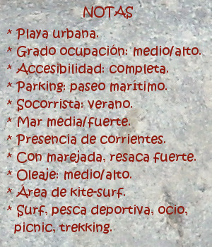
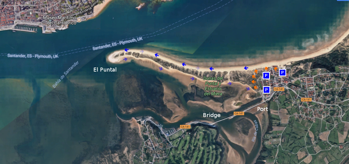
La playa situada en el extremo occidental es conocida como El Puntal, una lengua de arena con tres kilómetros de longitud. Bañada por el mar en sus dos vertientes, dispone de un recinto dunar; existente a lo ancho de su área. Su ruta de ida y vuelta requiere mesura y una condición física mínima. El camino se realiza por arena, o a través de pequeños senderos irregulares abiertos entre las dunas.
La ruta comienza en Somo. Desde cualquier localización podremos acceder a la playa y comenzar la travesía. Un punto de partida adecuado es el Embarcadero de Somo, cuenta con un amplio aparcamiento y varios accesos a las dunas. El camino empieza ofreciendo una vista panorámica de la bahía. La ciudad de Santander, al fondo, completa el mosaico. Cada paso irá acompañado por el sonido del oleaje. El color azulado y oscurecido del agua descubre una línea imaginaria que recorrer la orilla, invitando a continuar y descubrir su final. La arena húmeda que aparece en bajamar facilita la ruta que puede ser alternada sobre arena seca, acorde a nuestra condición física. A mitad de camino, sobre la silueta del banco de arena, aparece una curva interior seguida de otra exterior. En este punto, va asomando la ciudad, descubriendo su profundidad conforme avanzamos.
Al final del recorrido, un amplio espacio presenta singulares vistas de la Bahía de Santander. El atardecer lucirá un plano general enmarcado por el cielo y el entorno. El camino de regreso puede ser realizado volviendo sobre nuestros pasos o eligiendo el lados sur de El Puntal. Desde allí es posible disfrutar de otros espacios y localidades que comparten la bahía, finalizando con el Puente de Somo, la Ría de Cubas y el Embarcadero.
![]()
![]()
![]()
Somo, El Puntal. Trekking route
![]() Somo is a coastal locality Cantabrian placed in the south shore of the Bay of Santander. Located on the central coast of Cantabria, it arranges and has access to an extensive sandbank of more than 7 kilometres of length. This unique zone contains several beaches established on the open sea that receive the surge of the Cantabrian Sea.
Somo is a coastal locality Cantabrian placed in the south shore of the Bay of Santander. Located on the central coast of Cantabria, it arranges and has access to an extensive sandbank of more than 7 kilometres of length. This unique zone contains several beaches established on the open sea that receive the surge of the Cantabrian Sea.
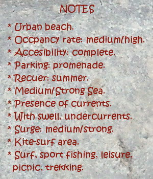
The beach placed in the western end is known as El Puntal, a language of sand with three kilometres of length. Sorrounded by the sea in its two slopes, it has a dune enclosure widthways its existing area. Its round trip route needs moderation and a minimum physical condition. The way is realized by sand, or across small irregular paths opened between the dunes.
The route begins in Somo. From any location we will be able to accede to the beach and to begin the voyage. An ideal point of is The Port of Somo, relies a wide parking and several accesses to the dunes. The way starts by offering a panoramic sight of the bay. The city of Santander, to the bottom, completes the mosaic. Every step will be accompanied by the sound of the surge. The color bluish and got dark of the water discovers an imaginary line that run cross the shore, inviting to continue and discover its end. The humid sand that appears in low tide facilitates the route that can be alternated over dry item, as allow our physical condition. To midway, on the silhouette of the sandbank, there appears an interior curve followed by exterior other one. In this point, the city is going appear, discovering its depth as we advance.
At the end of the tour, a wide space presents a singular views of the Bay of Santander. The sunset will illuminate an outlook framed by the sky and the environment. The return way can be realized over our steps or choosing the south side of El Puntal. From there it is possible to enjoy other spaces and localities that share the bay, finishing with the Bridge of Somo, the Estuary of Cubas and the Port.
![]()