Playa de Barnejo (Berellín), acceso

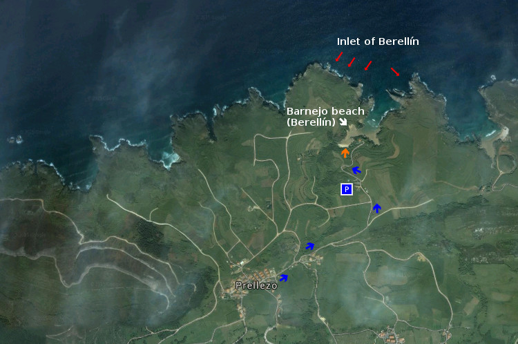
Icono Español. Icon Spanish. (Berellín), acceso La playa de Barnejo, o playa de Berellín, está situada en el pueblo de Prellezo. Es una idílica playa de singular belleza. Tiene un único acceso, a través de la carretera que uno el centro del pueblo con la playa. Cuenta con un pequeño aparcamiento, situado a 100 metros del arenal. Las características de Barnejo la convierten en un lugar ideal para practicar submarinismo, además del baño y el ocio.

Barnejo beach (Berellín), access

Icono. Icon. (Berellín), access The beach of Barnejo , or beach of Berellín, is placed in the town of Prellezo. It is an idyllic beach of singular beauty. It has an only access, across the road that connects the center of the village with the beach. It possesses an small parking, placed to 100 meters of the sandbank. Its characteristics turn Barnejo into an ideal place to practise scuba diving , besides the swimming and the leisure.

Icono español-inglés. Icon Spanish-English. Berellín Beach, acceso/access Acceso/Beach Access

Barnejo beach (Berellín)

Share

Playa de Barnejo (Berellín), localización

Icono Español. Icon Spanish. Playa de Barnejo, (Berellín) La playa de Barnejo, también llamada playa de Berellín, está situada en el pueblo de Prellezo, perteneciente al municipio de Val de San Vicente; en la costa occidental de Cantabria. La ruta finaliza en el centro de la localidad. Debemos continuar hasta el final, por la única carretera que llega a la playa. Se puede llegar a esta playa desde Oviedo, Palencia, Santander o Bilbao.

Barnejo beach (Berellín), Localization

Icono Inglés. Icon English. Barnejo beach (Berellín) The beach of Barnejo , also called beach of Berellín , is placed in the town of Prellezo , belonging to the municipality of Val de San Vicente; on the western coast of Cantabria. The route finishes in the center of the locality. We must continue to the end, through the only road that comes to the beach. It is possible to arrive to this beach from Oviedo, Palencia, Santander or Bilbao.

Icono Español-Inglés. Icon Spanish-English. Playa de Barnejo (Berellín). Barnejo beach (Berellín) Localización/Localization

Oviedo, Barnejo (Berellín): localizationPalencia, Barnejo (Berellín): LocalizationBilbao, Barnejo (Berellín): LocalizationSantander, Barnejo (Berellín): localization

Share

El Camello, acceso

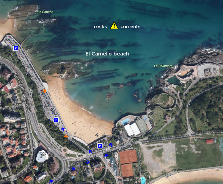
Icono Español. Icon Spanish. El Camello, acceso La playa de El Camello, situada en la ciudad de Santander, es un pequeño arenal en cuyas aguas alberga un arrecife rocoso de formas variopintas. Tiene dos accesos, acompañados de sendos aparcamientos. Apta para el baño y el ocio, es ideal para practicar submarinismo. Su fondo rocoso y la presencia de corrientes aconsejan realizar el buceo con las debidas precauciones.

El Camello, access

Icono. Icon. El Camello, access The beach of El Camello, placed in the city of Santander, is a small sandbank in whose waters it shelters a rocky reef with multiple and different forms. It has two accesses, accompanied of parkings. Suitable for the swimming and the leisure, it is ideal to practise scuba diving. Its rocky bottom and the presence of currents advise to realize the diving with the due precautions.

Icono español-inglés. Icon Spanish-English. El Camello, acceso/access Acceso/Beach Access

El Camello, access

Share

El Camello, localización

Icono Español. Icon Spanish La playa de El Camello está situada en la ciudad de Santander. Es una pequeña playa con abundante presencia de rocas y peculiar configuración. Sus características la convierten en una zona especial para practicar submarinismo, además del ocio y la pesca.Se puede llegar a esta playa desde Oviedo, Palencia, Santander o Bilbao.

El Camello, Localization

Icono Inglés. Icon English The beach of El Camello is placed in the city of Santander. It is a small beach with abundant presence of rocks and peculiar configuration. Its characteristics turn it into a special zone to practise scuba diving, besides the leisure and the fishing. It is possible to arrive to this beach from Oviedo, Palencia, Santander or Bilbao.

Icono Español-Inglés. Icon Spanish-English Localización/Localization

Oviedo, El_Camello: surf tourPalencia, El Camello: surf tourBilbao, El Camello: surf tourSantander, EL Camello: surf tour

Share

Playa de Covachos, acceso

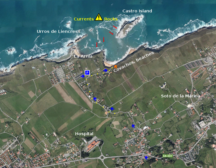
Icono Español. Icon Spanish. Playa de San Julián La Playa de Covachos está situada en la localidad de Soto de la Marina, perteneciente al municipio de Santa Cruz de Bezana. Es una ensenada de gran belleza, ubicada en mar abierto y coronada por la Isla del Castro; que habilita dos playas en la misma zona. El aparcamiento es escaso y alejado de la entrada al arenal. El acceso se hace por medio de una escalera construida sobre el acantilado en su parte más baja.

Consejo: tener precaución por las fuertes corrientes y la fuerza del mar en la zona.

Beach of Covachos, access

Icono Inglés. Icon English. Playa de San Julián The Beach of Covachos is placed in the locality of Soto de la Marina, belonging to the municipality of Santa Cruz de Bezana. It is an inlet of great beauty, located on the open sea and crowned by the Island of the Castro; that creates two zones in the same beach. The parking is scanty and it is removed of the entry to the sandbank. The access is done by means of a stairs constructed on the cliff in his lower part.

Advice: to take precaution as the strong currents and the power of the sea in the zone.

Icono español-inglés. Icon Spanish-English. Playa de San Julián Acceso/Access

Access, Covachos

Icon close Sponsor

Share

De La Maruca a La Vaca. Ruta de Senderismo

Icono Español. Icon Spanish. Ruta: De La Maruca a La VacaLa Maruca está ubicada en la localidad de Monte, perteneciente al municipio de Santander. Es la Maruca un puerto natural emplazado en la costa norte de la ciudad y blasonada por la orografia del litoral que esculpe el Mar Cantábrico.

Su paseo marítimo cuenta con un amplío parking desde donde comenzar la ruta. Una vez situados en ese punto, podemos contemplar la belleza de este puerto. Pequeñas barcas de pescadores se agolpan hacia el interior y el lado izquierdo del mismo. Allí desemboca la Ría de San Pedro, contribuyendo a modelar la singular forma de La Maruca. Al alcance de nuestra vista se eleva una estatua gigante de un pescador, homenaje a la gente del mar. En el lado derecho del paseo marítimo se puede visitar el Centro de Interpretación del Litoral, pequeño museo dedicado al mar y la costa de Cantabria.

Continuando el camino, a la otra parte del CIL, aparece la Playa de Rosamunda. Es pequeña y sólo hábil en marea baja. Su principal uso esta destinado a la pesca recreativa desde sus rocas. Los días en los que la mar esta plana es posible realizar submarinismo. Doradas, perlas, salmonetes, y jargos son algunas de las espcecies de peces que podemos encontrar. Su fondo rocoso e irregular se entremezcla con la arena que el oleaje deposita en la base de esta zona. Un momento de pausa en este lugar hace que los límites de La Maruca varíen y difuminen sus fronteras entre el azul del cielo nuboso y el azul oscuro del mar.

Ahora el sendero transcurre paralelo al acantilado, marcado en el suelo por el uso. El oleaje al encuentro con las rocas dispara el agua, haciendo que la espuma se suspenda en el aire. Las pequeñas gotas de agua y el olor puro del mar acompañan la travesía. En el otro extremo, y después de atravesar este escenario, la arena abundante en una esquina nos hace intuir la entrada natural y más cómoda a la playa.

Llegamos a un pequeño cabo dentro de este entorno. Entre los muros de las fincas particulares y el mar, se encuentra la roca por la que caminamos. Va perdiendo gradualmente su altura hasta finalizar a nivel del mar. La última parte del tramo es un acantilado a cuyo resguardo llegan las olas que entran en la Playa del Bocal. Su irregular fondo de roca, afilada por las olas, aumenta el disfrute de esta imagen contemplada desde tierra firme. Nacen , en la distancia cercana, unas olas características. Su tamaño medio y su definido recorrido estimulan la imaginación. Cuando las olas crecen de tamaño, succionan con mayor fuerza el fondo, dejando entrever a poca distancia de la superficie del agua, el fondo rocoso. A nuestra espalda, una base el Instituto Español de Oceanografía.

Al final de este tramo asoma la entrada a la Playa del Bocal. Avanza el sendero irregularmente hasta llegar a campo abierto. Las vacas pastan libres en este lugar. Una valla electrificada las separa de los caminantes. Paso a paso subimos una pequeña y suave colina formada por vegetación y roca kárstica. Desde ella divisaremos la última cala del trayecto, aquella donde se origina y habita una de las olas más grandes de Cantabria: La Vaca Gigante.

La Maruca to La Vaca. Trekking route

Icono Inglés. Icon English. Route: La Maruca to La Vaca La Maruca is located in the town of Monte, belonging to the municipality of Santander. It is a natural harbor located on the north coast of the city and blazon by the orography of the coastline that sculpts the Cantabrian Sea.

Its promenade has a large car park from where to begin the route. In that point, we can contemplate the beauty of the port. Small fishing boats are crowded toward the inside and the left-hand side of the same. That place is The Stuary of San Pedro, helping to shape the unique configuration of La Maruca. In the scope of the view is raised a giant statue of a fisherman, a tribute to the people of the sea. On the right side of the promenade you can visit the Interpretation Center of the Coastline, small museum dedicated to the sea and the coast of Cantabria.

Continuing along the path, to the other part of the CYL, appears the Beach of Rosamunda. It is small and only available at low tide. Its main use is intended for the recreational fishing from the rocks. The days on which the sea is flat it is possible to make scuba diving. Gold, pearls, red mullet, and jargos are some of the espcecies of fish that we can find. Its rocky bottom and irregular is intermingled with the sand that the waves deposited in the base of the zone. A moment of pause in this place makes the limits of La Maruca may vary, and blur their boundaries because of the blue of the sky , the clouds and the dark blue of the sea.

Now the path runs parallel to the cliff face, marked on the ground by use. The waves to the encounter with the rocks shoot the water, making that the foam is suspended in the air. The small drops of water and the fresh sea smell accompany the voyage. On the other end, and after crossing this scenario, the sand in a abundant corner makes us sense the natural and more convenient entrance to the beach.

We arrived in a small cape within this environment. Between the walls of the private farms and the sea, is the rock through which we walked. It gradually lose their height up to finish at sea level. The last part of the zone is a cliff which guards the arrival of the waves that fall on the Beach of El Bocal. Its irregular rocky sea bottom, sharpened by the waves, increases the enjoyment of this image when we see it from the mainland. Some particular waves appear in the close distance. Its medium size and its defined path stimulate the imagination. When the waves grow in size, the sea sucks with greater force the fund, showing the rocky bottom near the surface of the water. To our backs, a basis of the Spanish Institute of Oceanography.

At the end of this stretch is the entrance to the beach El Bocal. The trail moves irregularly until you get to open field. The cows graze free in this place. An electric fence separates the hikers from the animals. Step by step we climb a small and soft hill, formed by vegetation and karstic rock. There we will see the last cove of the journey, where borns and inhabits one of the biggest waves in Cantabria: «La Vaca Gigante».

Icon close Sponsor

Share

Playa de Mataleñas. Una cala dentro de Santander

Icono Español. Icon Spanish La playa de Mataleñas está situada en la ciudad de Santander. Se encuentra emplazada entre Cabo Menor y Cabo Mayor. Su arenal tiene 125 metros de longitud y una anchura aproximada de 40 metros. Flanqueada por acantilados que esculpe el Mar Cantábrico, estas barreras naturales acompañan a la cala 250 metros antes de llegar a mar abierta.

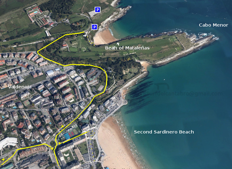
Localización : una vez situados en la ciudad de Santander, nos dirigiremos hacia la Segunda Playa del Sardinero. Desde allí cogemos dirección al Faro de Cabo Mayor. Pasado el Barrio de Valdenoja, subiendo la cuesta, al final hay un desvío a mano derecha que da acceso a un mirador desde donde contemplar parte de la Bahía de Santander y la Playa de Mataleñas.

Acceso : cuenta con un pequeño parking cercano a su escalinata de entrada. Se baja a la playa a través de las escaleras que traducen una altitud de 40 metros, hasta amenizar a nivel del mar, en un pequeño balcón abarandillado que nos presenta la cala de una forma singular.

La playa de Mataleñas es apta para el baño, ir de comida, pesca a surfcasting y el submarinismo. Sus aguas limpias y de color azul verdoso traslucen parte del paisaje submarino que puede encontrarse al bucear en la zona. Lubinas, doradas, perlas, cabras, cabrachos y agujones son algunas de las especies de peces que vamos a encontrar. Acompañados de crustáceos y algas rodeados por cuevas y roca tallada por el Cantábrico.

La playa de Mataleñas se comunica con los siguientes puntos : Faro de Cabo Mayor, Cabo Menor, Parque de Mataleñas, recorrido periférico del Campo de Golf de Mataleñas, El Sardinero. Es por ello que se convierte en una zona ideal para realizar rutas de senderismo con diversos recorridos.

Separador. DividerIcono Español-Inglés. Icon Spanish-Englishaccess, localization: mataleñas beachIcono separador. Icon divider

Beach of Mataleñas. A cove within Santander

Icono Inglés. Icon English The Beach of Mataleñas is located in the city of Santander. It is placed between Cabo Menor and Cabo Mayor. Its arenal has 125 meters in length and a width of approximately 40 meters. Flanked by cliffs that sculpts the Cantabrian Sea, these natural barriers accompany the cove through 250 meters before arriving to open sea.

Location : once placed in the city of Santander, we go toward the Second Sardinero Beach. From there take the road to the Lighthouse Cabo Mayor. Then the last neighborhood, Valdenoja. Just up the hill, at the end, there is a diversion on the right hand which gives access to a vantage point from where you can watch part of the Santander Bay and the Beach of Mataleñas.

Access : account with a small parking close to its entrance staircase. You can arrive to the beach through the stairs. That translate an altitude from 40 meters to sea level. At the end, an small balcony balustraded presented to us the cove in a singular way.

The beach Mataleñas is suitable for the bathroom, picnic, surfcasting and scuba diving. Its clean waters and greenish blue color show part of the underwater scenery that can be found when diving in the area. Sea Bass, golden, pearls, goats, scorpion fish and agujones are some of the species of fish that we are going to find. Accompanied by crustaceans and algae surrounded by caves and rock carved by the Cantabrian Sea.

The beach of Mataleñas communicates with the following points: Lighthouse Cape Mayor, Cape Menor, Mataleñas’s Park, peripheral road of Mataleñas’s Golf course, The Sardinero. It is for it that turns into an ideal zone to realize routes of trekking with diverse tours.

Icon close Sponsor

Share

Isla de Mouro, origen del nombre

Icono Español. Icon Spanish El origen del nombre de Isla de Mouro se remonta al siglo XVIII que es cuando se realiza el primer Atlas Hidrográfico de España. En ese libro se incluían todas las islas de nuestro páis, entre las que se encontraba la que hoy conocemos como Isla de Mouro. Su nombre original era Isla de Mogro, pero debido a un error en la transcripción hecha por el cartógrafo Vicente Tofiño de San Miguel, se registro el nombre Isla de Mouro, que se ha conservado hasta nuestros días.

La palabra «Mogro» designa a una localidad costera cantabra próxima a Santander. Su significado es sinónimo de «castro«, el cual se refiere a poblado fortificado celta, generalmente prerromano. La palabra castro proviene del latín «castrum«, que significa fortificación militar.

Island of Mouro, origin of the name

Icono Inglés. Icon English The origin of the name of the Island of Mouro goes back to the eighteenth century that is when the first Hydrographic Atlas of Spain had been done. In that book were included all the islands of our country. Among the islands, Mouro Island. Its original name was Island of Mogro, but due to an error in the transcript by the cartographer Vicente Tofino of San Miguel, the name of Island of Mouro was recorded and it has been preserved until our days.

The word «Mogro» designates a Cantabrian coastal town next to Santander. Its meaning is a synonym for «castro«, which refers to Celtic oppidum, pre-roman generally. The word castro comes from the latin «castrum«, which means military fortification.

Icon close Sponsor

Share

Isla de Mouro

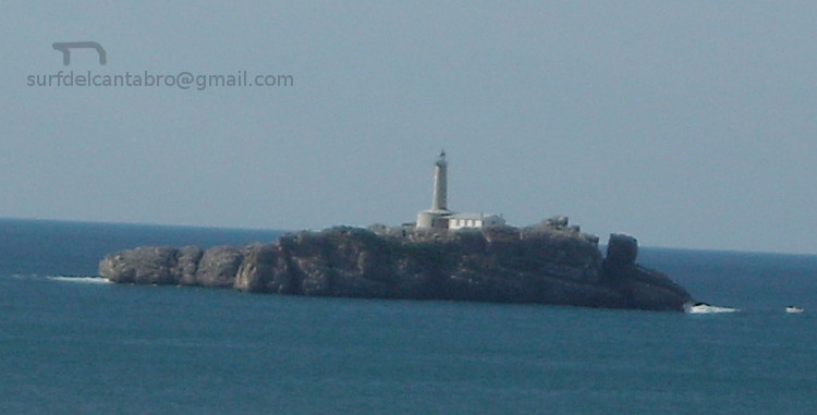
Icono Español. Icon Spanish La Isla de Mouro se encuentra ubicada a la entrada de la Bahía de Santander. Está situada entre La Península de la Magdalena y la Isla de Santa Marina. Ocupa un espacio de 1,7 hectáreas. Formada por rocas que acantilan todo su contorno, en su parte alta es prácticamente llana y cuenta con un faro que en la actualidad está automatizado, llamado Faro de La Isla de Mouro.

Es un lugar ideal para practicar submarinismo por la riqueza de sus fondos. Tiene una flora abundante y variada. Destaca la presencia de una planta, el hinojo marino. Es una especie muy utilizada como condimento gastronómico. Ya en el siglo XVI los buques franceses, ingleses y flamencos en su camino de vuelta desde Santander se aprovisionaban de ella en la Isla de Mouro.

La Isla de Mouro cuenta con una población de aves que nidifican en ella. Las especies de peces que la habitan y visitan es abundante, pues a la riqueza de sus fondos marinos se añade su emplazamiento. A la entrada de la bahía y próxima a su canal. Registra una gran parte de las especies de peces que se pueden encontrar en el Mar Cantábrico.

Destaca como hecho histórico la conquista de la isla por parte de los ingleses a la tropas napoleónicas, durante la Guerra de la Independencia Española (1808 – 1814). Siendo Inglaterra aliada de España.

Mouro Island

Icono Inglés. Icon English The Mouro Island is located at the entrance to the Bay of Santander. It is placed between the Peninsula of la Magdalena and the Santa Marina Island. It occupies an area of 1.7 hectares. Formed by rocks that acantilan all around, in its upper part is virtually flat and with a lighthouse which is now automated, called Lighthouse of Mouro Island.

It is an ideal place to practise diving for the wealth of its funds. It has an abundant and varied flora. It emphasizes the presence of a plant, the marine fennel. It is a species much used as gastronomic seasoning. Already in the XVIth century the French, English and Flemish ships in its way back from Santander were supplied of it in the Island of Mouro.

The Mouro Island has a population of birds that nest in it. The species of fish that inhabit and visit it is abundant, because of the wealth of its seabed and its location. At the entrance to the bay and next to its channel. Registers a large part of the fish species that can be found in Cantabrian Sea.

Stands out as historical fact the conquest of the island by the British to the Napoleonic troops, during the Spanish War of Independence (1808 – 1814). Being England ally of Spain.

Separador. DividerIcono Español-Inglés. Icon Spanish-English
islademouro
islademouro2Icono separador. Icon divider

Icon close Sponsor

Share

La península de La Magdalena: submarinismo

Icono Español. Icon Spanish La península de La Magdalena se encuentra en la ciudad de Santander. Tiene una superficie de 24,5 hectáreas. En la actualidad la península es un parque público abierto durante el día. Su horario de verano es de 8:00 a 22:00, el resto del año de 9:00 a 20:30.

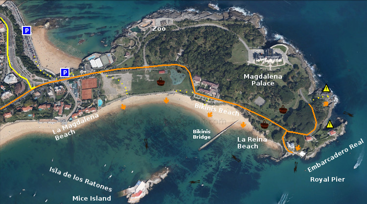
En ella, están la Playa de la Magdalena, la Playa de Bikinis y la Playa de la Reina. Son zonas de aguas claras y tranquilas. Generalmente tienen poca o nula presencia de olas y es por ello que son ideales para el baño, y el disfrute de la playa. Dentro del parque se puede hacer pícnic, habiendo varias zonas con mesas habilitadas para ello. Estas zonas además si sitúan al lado de la playa.

En la propia ciudad se encuentra esta pequeña joya de la naturaleza, la península de La Magdalena. Concebida en la actualidad para el uso mundano y el disfrute divino. Destaca en ella la practica del submarinismo. El rápido y fácil acceso al lugar. Las aguas claras. La tranquilidad del mar que baña la península por el interior de la bahía. Todos estos factores propician un buceo de calidad.

Varios son los puntos de entrada para hacer submarinismo. Desde las playas de La Magdalena y Bikinis se recorre la pequeña ensenada acotada por la Isla de los ratones y el Puente de Bikinis. Desde el puente podemos rodear la isla o acercarnos al Embarcadero Real. Desde el embarcadero se realiza la travesía hacía una parte de la cara norte de la península. Situados en el acceso noreste es posible elegir alguno de los puntos anteriores o conocer los fondos marinos próximos al punto de entrada y situados bajo el Palacio de la Magdalena.

A través del buceo se descubre un paisaje submarino difícil de imaginar desde tierra. Diversidad de peces, moluscos y crustáceos nadan y caminan conforme avanzamos la ruta elegida. Lubinas, doradas, cabrachos, salmonetes y jargos conviven con distintas especies de moluscos cefalópodos como la sepia y el magano (calamar pequeño). Ambos buscan su alimento entre mejillones, lapas, caracolillos de mar y varios tipos de crustáceos. El fondo de arena blanca se entremezcla con las rocas. Rocas que forman canales y figuras, modeladas por las condiciones meteorológicas y el paso del tiempo. Son un testimonio «vivo» del pasado geológico de La Península de la Magdalena.

Separador. DividerIcono Español-Inglés. Icon Spanish-EnglishAcceso, buceo: La MagdalenaIcono separador. Icon divider

The Magdalena peninsula: scuba diving

Icono Inglés. Icon English The Magdalena peninsula is located in the city of Santander. It has an area of 24.5 hectares. At present, the peninsula is a public park open during the day. Its summer opening hours are from 8:00 to 22:00, the rest of the year from 9:00 to 20:30.

In it, are the Magdalena Beach, Bikinis Beach and The beach of the Queen. All of them are areas of clear and calm waters. Generally have little or no presence of waves so it is an ideal place for the swimming, and the enjoyment of the beach. Within the park you can picnic, having several areas with tables set aside for this purpose. These tables are near the beach.

In the city is this little gem of the nature, the «peninsula de la Magdalena». Conceived today for use worldly and the divine enjoyment. It stands out in the practice of scuba diving. The quick and easy access to the site. The crystal clear waters. The tranquility of the sea, which washes the peninsula by the interior of the bay. All these factors contribute to a quality scuba diving.

There are several entry points for diving. From the beaches of La Magdalena and Bikinis you can go to the small bay delimited by the Mice Island and the Bikinis Bridge. From the bridge we can surround the island or go to the Royal Pier. From the jetty is performed the journey toward a part of the north face of the peninsula. Located in the northeast access is possible to choose any of the above points or know the seabed near the entry point and located under the Magdalena Palace.

Through the scuba diving here you are going to discover a submarine landscape hard to imagine from the ground. Diversity of fish, molluscs and crustaceans swim and walk as we go along the route chosen. Sea Bass, golden, scoprpion fish, red mullet and jargos coexist with various species of cephalopod mollusks such as sepia and the magano (small squid). Both are looking for its food between mussels, limpets and sea snails and several types of crustaceans. The seabed of white sand is intermingled with the rocks. Rocks that form channels and figures, modeled by the weather and the passage of time. Living witnesses in the geological past of the «Peninsula de la Magdalena».

Icon close Sponsor

Share