Después de la última serie, nos agrupamos de nuevo. Esta vez avanzamos mar adentro, donde nacían las olas; para surfearlas desde el comienzo. El nacimiento de las olas es bastante relativo cuando la mar está salvaje y revuelta. Pues, debido a las fuertes condiciones, el oleaje se crea en varias áreas y de manera aleatoria o más bien difícil de predecir. Con este escenario es casi seguro desperdiciar fuerzas, necesarias para disfrutar plenamente del surf y ser consciente del respeto que el mar impone.
A 300 metros de la orilla, con la marea en su punto más alto, el mar se fue calmando. Las series de olas retornaron a su regularidad. Habían reducido su tamaño hasta los dos metros y medio, conservando algún gigante en el grupo. Tomé aire para recuperar el esfuerzo. La línea de playa se veía pequeña. En el paseo marítimo se agolpaba un grupo de gente que disfrutaba del espectáculo. Esta imagen aparecía y desaparecía con el transcurso de las series. Cien metros adelante, en dirección a la orilla, las olas se erguían imponentes sobre los tres metros y medio. Hablábamos entre nosotros sobre su tamaño. Un surfer experimentado, colocado en un extremo, explicaba como debíamos actuar en un escenario así. Sus manos describían la trayectoria óptima y las mejores maniobras. Concluyó diciendo que una ola grande no se maneja, se debe «seguir». Los minutos pasaron entre comentarios y risas. En mi se despertó la curiosidad de poner en práctica lo que aquel hombre comentó. En el aire se respiraba un ambiente especial, La adrenalina impulsaba a la pasión que el mar provoca. Aquella conversación llamó a las puertas de un nuevo camino.
Media hora después asomo un gigante de cuatro metros en la segunda ola de la serie. El colega, que estaba situado en el extremo, se alzó sobre la tabla; al contacto con la ola. Bajó hasta la base y giró armoniosamente. Vi como su tabla botaba sobre el agua. Dirigió su trayectoria hacia la cresta y consiguió estabilizarse. Cruzó por delante del grupo, a gran velocidad. Gritamos emocionados. Las olas posteriores fueron de menor tamaño.
Tres personas quedábamos en el agua. Llegaba el momento de retirarse y disfrutar lo vivido. Yo sólo pensaba en un nuevo mastodonte. Las fuerzas menguaban y la idea de coger una gran ola se iba desvaneciendo. Otro chico cogió una ola de medio tamaño y llegó con ella hasta la orilla. Volví la mirada hacia el mar. Un gran volumen de agua, que tenía dos metros altura, asomó en el horizonte. Su sonido hizo girarse al otro compañero. Ampliamos la distancia entre nosotros. Cuando me alcanzó, superaba los tres metros. El camino hasta la base golpeó con vértigo mi pecho. Recordé la conversación e intenté hacer un giro rápido y armonioso. Me dirigí a la cresta. La incertidumbre y la emoción que sentía plasmaron en mi una sonrisa. Corrigiendo la trayectoria conseguí estabilidad. La velocidad sonaba entre la superficie del agua y la tabla. Cerca de la orilla conseguí apearme.
Las emociones llenaban los pensamientos, que no conseguían tomar forma. Desbordado, feliz, satisfecho. Así acabó el día al que denomino como: «el día de mar grande».
Big Sea. Part C
 After the last series, we gathered again. This time we moved some distance offshore, where the waves were borning; to surf them in the beginning. The source of the waves is quite relative when the sea is savage and revolt. Therefore, due to the strong conditions, the swell is created in several areas and on a random basis or exactly rather difficult to predict. With this scenario is almost certainly that you be wasted forces, necessary to fully enjoy the surf and be aware of the respect that the sea imposes.
300 Meters from the shore, with the tide in its highest point, the sea was calmed down. The series of waves returned to their regularity. Had reduced its size up to two and a half meters, preserving some giant in the group. I take air to recover my effort. The line of the beach was small. In the promenade there were a group of people who were enjoying the show. This image appeared and disappeared with the course of the series. One hundred meters ahead, in the shore direction, the impressive waves were rising over the three and a half meters. We talked among ourselves about its size. An experienced surfer, placed in one end, explained the movements and behaviour in such a scenario. His hands described the optimal path and the best maneuvers. He concluded by saying that a big wave is not handled, it must be followed. The minutes passed between comments and laughter. In my mind, it was awakened curiosity of putting into practice what the man said. In the air was breathed a special atmosphere, the adrenaline drove the passion that the sea creates. That conversation knocked at the doors of a new path.
Half an hour later appeared a giant, with four meters, in the second wave of the series. The colleague, that was located in the end, stood up on the board; when the wave contacted him. He moved to the base and he turned with armony. I saw as his board was jumping over the water. He directed his course toward the top and got stabilized. He crossed in front of the group, at high speed. We shouted excited. The subsequent waves were of smaller size.
Three people were staying yet in the water. The time came to retire and enjoy what each one had experienced. I only thought about in the new giant that would come. The forces became scarcer and the idea to catch a great wave was fading. Another boy grabbed a wave of medium size and came with her to the shore. I returned the gaze toward the sea. A large volume of water, which had two meters height, appeared on the horizon. Its sound caused that the other surfer was turned to it. We increased the distance between us. When it reached me, it exceeded over three meters. The way to the base hit my chest with vertigo. I recalled the conversation and tried to make a quick and harmonius rotation. I went to the crest. The uncertainty and the emotion that I felt drew an smile. I corrected the trajectory and I got stability. The speed sounded between the surface of the water and the board. Near the shore, I dismounted from the wave.
The thoughts were filling with emotions, and them could not take shape. I was overflowed, I felt happy and satisfied. That was the end of the day that I termed as: «the day of big sea«.

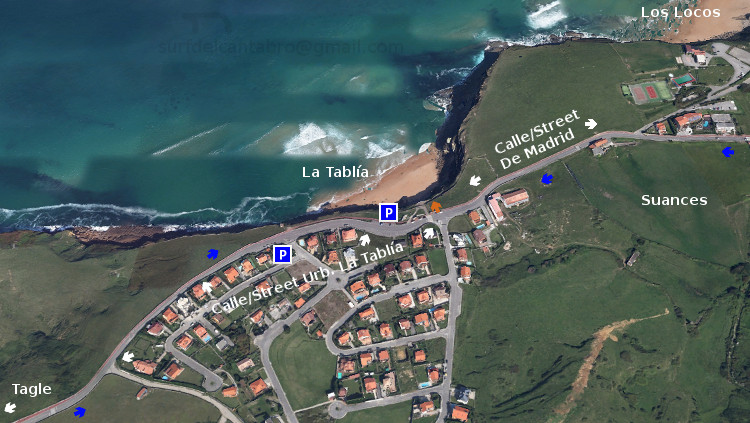
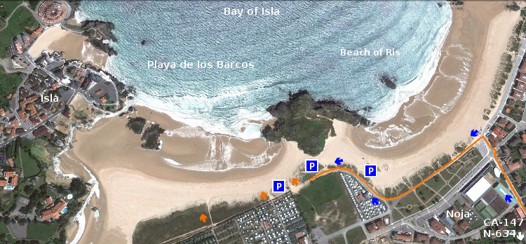
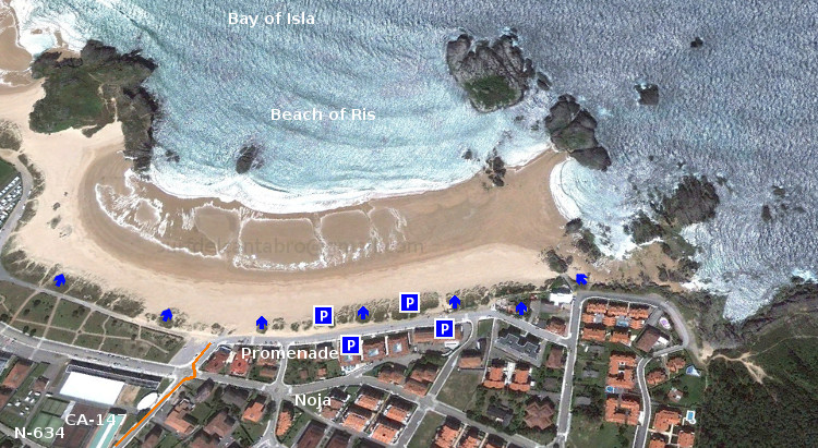
 Localización/Localization