Playa de los Peligros: Windsurf, Kitesurf

Icono Español. Icon Spanish La Playa de Los Peligros está situada en la ciudad de Santander, junto a la Playa de la Magdalena.

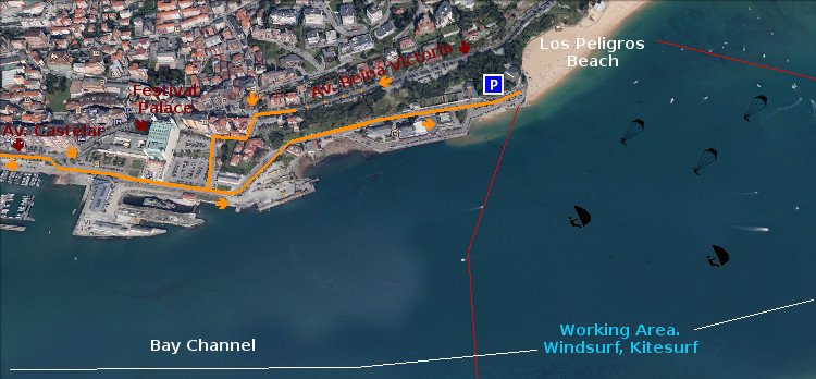
Para llegar a Los Peligros hay dos vías. La primera desde la Calle Castelar cogiendo el desvío a mano derecha para ir al Palacio de Festivales de Cantabria. Después continuamos la carretera hasta el final. La segunda opción desde la Avenida Reina Victoria, viniendo de la península de la Magdalena. Al Final de la avenida, girando a la izquierda se accede a parte del recorrido anterior.

Los Peligros es una playa de arena blanca y fina. Sus aguas son tranquilas y sin oleaje. Es adecuada para el baño, el disfrute del mar y su arenal. Cuenta con un parking amplio que se suele llenar en verano. El paseo hasta la playa constituye en sí mismo un pequeño viaje. Al tiempo que se ve una parte portuaria antigua de la ciudad se visualiza la Bahía de Santander y un puzzle montañoso al fondo.

Los días de viento esta sencilla zona se convierte en un circuito deportivo frecuentado por velas y cometas de winsurf y kitesurf. Desde la playa se entra a estas autopistas virtuales que cuentan con suficiente espacio para disfrutar de estas modalidades de surf. En este lugar generalmente el viento está presente en mayor o menor grado. Convirtiendo a la playa de Los Peligros en un lugar ideal para la práctica del windsurf y kitesurf.

Playa de Los Peligros: windsurf, kitesurf

Icono Inglés. Icon English Los Peligros Beach is located in the city of Santander, next to the Magdalena Beach.

To reach Los Peligros there are two ways. The first from the Castelar Street. Taking the detour to the right to go to the Palacio de Festivales de Cantabria. Then we continue the road to the end. The second option from the Avenida Reina Victoria, coming from the peninsula of la Magdalena. At the end of the avenue, turning to the left to access part of the above route.

Los Peligros is a beach of fine and white sand. Its waters are calm and without waves. It is suitable for the swiming, the enjoyment of the sea and its arenal. Account with an ample car parking which is usually fill in summer. The walk down to the beach is a small trip. At the same time that we see a part of the ancient port part of the city is displayed the Santander Bay and a puzzle of mountains in the background.

The windy days this area becomes a sporting circuit frequented by sails and kites of windsurfing and kitesurfing. From the beach you access to several and endless virtual highways that have enough space to enjoy these modalities of surfing. The wind is usually present to a greater or lesser degree in this zone. Turning to Los Peligros Beach in an ideal place for windsurfing and kitesurfing.

Separador. DividerIcono Español-Inglés. Icon Spanish-EnglishLos PeligrosIcono separador. Icon divider
Icon close Sponsor

Share

El viento extremo, un motivo para una ola gigante

Icono Español. Icon Spanish. El viento extremo La fuerza extrema del viento es uno de los factores que dan lugar olas gigantes. Durante este invierno se han sucedido temporales, borrascas y ciclogénesis explosivas en el Mar Cantábrico con una frecuencia inusual. ¿ Cuál es la causa ?. Leer más … Icono. Icon

The extreme wind, a reason for a giant wave

Icono Inglés. Icon English. The extreme wind The extreme force of the wind is one of the factors that give place giant waves. This winter there have been temporary, squalls and explosive cyclogenesis in the Cantabrian Sea with an unusual frequency. What is the cause? Read more … Icono. Icon

Separador. DividerIcono Español-Inglés. Icon Spanish-English. El viento extremo. The extreme windIcono. Icon
Icono separador. Icon divider

Icon close Sponsor

Share

Segunda Playa del Sardinero, acceso

Icono Español. Icon Spanish. Segunda Playa del Sardinero. La Segunda Playa del Sardinero tiene varios accesos. Está rodeada por el Parque de Mesones y desde el parque se puede acceder a la playa por multitud de puntos. La entrada principal se localiza cerca del final del Parque de Mesones. Más a la izquierda, se encuentra ya el final del paseo y a la derecha de la playa, los Jardines de Piquío. Desde estos dos lugares se dispone de sendos accesos.

Second Sardinero Beach, access

Icono Inglés. Icon English. Second Sardinero Beach. The Second Sardinero Beach has several access. The beach is surrounded by the Mesones Park and from the park you can access to the beach by different points. The main entrance is located near the end of the Mesones Park. The left side is the end of the avenue and on the right hand of the beach, there are the Piquío Gardens. From these places are available another two accesses.

Icono Español-Inglés. Icon Spanish-English. Segunda Playa del Sardinero. Second Sardinero Beach. Acceso/Beach Access

Acceso: Segunda playa del Sardinero. Access: Second Sardinero Beach

Share

Primera Playa del Sardinero, acceso

Icono Español. Icon Spanish. Primera Playa del Sardinero. La Primera Playa del Sardinero tiene múltiples accesos pues un paseo ajardinado la flanquea. Los tres principales accesos son los que se comentan a continuación. Desde el parking de la playa del Camello, se accede directamente a la parte derecha de la playa. Desde la Plaza de Italia, donde se localizan la mayor parte de restaurantes, atravesando los bajos del Sardinero; se llega directamente al centro de la playa. Desde los Jardines de Piquío, bajando las escaleras se accede a la parte izquierda de la Primera Playa del Sardinero.

First Sardinero Beach, access

Icono Inglés. Icon English. First Sardinero Beach The First Sardinero Beach has multiple accesses through the garden that flanks the beach. The three main accesses are discussed below. From the parking area of «El Camello» beach, you can directly access the right side of the beach. From the Plaza of Italy, where are located most of the restaurants, going through Sardinero main access; you will arrive to the center of the beach. From the Piquío Gardens, down the stairs is accessed to the left side of the First Sardinero Beach.

Icono Español-Inglés. Icon Spanish-English. Primera Playa del Sardinero. First Sardinero Beach Acceso/Beach Access

Acceso: Primera Playa del Sardinero, acceso. First Sardinero Beach, access

Icon close Sponsor

Share

Galizano. Acceso

Icono Español. Icon Spanish La Playa de Galizano tiene un único acceso a través de la localidad de Galizano. Se puede llegar a ella desde Santander por: la autovía A8, la carretera nacional CA-146 y la rotonda que enlaza esta última con la CA-141. Desde Bilbao por: A8,CA-147 y CA-141. Una vez en la localidad es fácil llegar al parking desde el que se puede acceder a las playas. La Playa de Arenilla está situada a la izquierda, adyacente, de la Playa de Galizano.

Nota: Aconsejo utilizar este acceso directo desde Galizano. Por las peculiaridades de esta parte de la costa cántabra. Pues es abundante en pequeñas fincas y carreteras anexas. Se puede convertir en un laberinto si no se conoce.

Galizano. Access

Icono Inglés. Icon English Galizano Beach has a unique access through the town of Galizano. You can reach it from Santander by: highway A8, CA-146 national road and the roundabout that connects with the CA-141. From Bilbao: A8, CA-147 and CA-141. Once in the village is easy to come to the parking from which you can access the beaches. «Arenilla» beach is located to the left, adjacent to Galizano beach.

Note: You can access from another ways, but I would advise to use this shortcut from Galizano. Due to the peculiarities of this part of the Cantabrian coast that is abundant on small farms and adjacent roads. If you don´t know it previously this place can become a maze.

Icono Español-Inglés. Icon Spanish-English Acceso/Beach Access

Acceso:Galizano

Icon close Sponsor

Share

olas gigantes en el mar cantábrico

Icono Español. Icon Spanish. Olas gigantes en el Mar Cantábrico. El temporal de borrascas continuadas azota el Mar Cantábrico desde el mes de enero. En febrero continua esta situación y ya son varias las ciclogenesis explosivas que se han vivido. Esta situación provoca la aparición de olas gigantes. El pasado 1 de febrero se captó en Asturias una ola de de 20,87 metros

Giant waves in the Cantabrian Sea

Icono Inglés. Icon English. Big waves in the Cantabrian Sea The storms continued sweeping the Cantabrian Sea since the month of January. In february continues this situation and several explosive cyclogenesis have been lived already in the coast. This situation causes the appearance of giant waves. The last February 1 a wave of of 20.87 meters was captured in Asturias …

Separador. DividerIcono Español-Inglés. Icon Spanish-EnglishIcono. Icon. Olas gigantes en el Mar Cantábrico. Big waves in the Cantabrian SeaIcono separador. Icon divider
Icon close Sponsor

Share

El Brusco, acceso. Naturaleza salvaje

Icono Español. Icon Spanish. El Brusco, acceso El Brusco puede ser accedido desde el oeste por Santander. A través de la autovía A8, la carretera nacional N-634 y finalizando en el cruce entre las carreteras nacionales CA-141 y CA-147. Desde el este por Bilbao utilizando la autovía A8, las carreteras nacionales N-634 y CA-141 y finalizando en el cruce de esta última con la carretera nacional CA-147.

Nota: Si usted visita la villa de Noja, cruzando el Paseo de Tregandín llegará al Monte El Brusco y a su playa.

El Brusco, access. Wild Nature

Icono Inglés. Icon English. El Brusco, access «El Brusco» can be accessed from the west by Santander. Through the A8 motorway, the national road N-634 and ending at the crossroad between the national roads CA-141 and CA-147. From the east by Bilbao using the motorway A8, and the national road N-634 and CA-141 and ending at the junction of the latter with the national highway CA-147.

Note: If you visit the villa of Noja, crossing the Walk of Tregandín you will arrive to El Brusco Mountain and its beach.

Icono Español-Inglés. Icon Spanish-English Acceso/Beach Access

El Brusco, acceso/access

Icon close Sponsor

Share

El Brusco, localización

Icono Español. Icon Spanish «El Brusco» está situado al final de la playa de Trengandín, perteneciente al municipio de Noja. La segunda mitad de la playa; debido a que su acceso se realiza por el barrio de Helgueras, recibe el nombre de playa de Helgueras. Al final de la playa de Helgueras se encuentra el Monte el Brusco, de ahí que esta zona final de la playa se conozca con el mismo nombre: El Brusco. Se puede llegar al Brusco desde Oviedo, Palencia, Santander o desde Bilbao. Cualquier viaje con distinto origen comparte final de recorrido con el trayecto que se hace desde los puntos de partida anteriores. Comenzando por autovía y finalizando por carretera nacional.

El Brusco, Localization

Icono Inglés. Icon English «El Brusco» is located at the end of Tregandín beach, belonging to the municipality of Noja. The second half of the beach; due to its access is performed by the neighborhood of Helgueras, receives the name of Helgueras beach. At the end of the Helgueras beach is The Brusco mountain, so this area is known with the same name. You can reach «El Brusco» from Oviedo, Palencia, Santander or Bilbao. Any trip with another origin shares the end of travel with the journey that is made from the above starting points. Starting by motorway and ending by national road.

Icono Español-Inglés. Icon Spanish-English Localización/Localization

Oviedo, El Brusco: LocalizationPalencia, El Brusco: LocalizationBilbao, El Brusco: localizationSantander, EL Brusco: Localization

Icon close Sponsor

Share