Monthly Archives: noviembre 2015

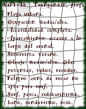
Trengandín, playa
![]() La playa de Trengandín está ubicada en el municipio de Noja, en la costa oriental de Cantabria. Es uno de los arenales más extensos de la costa cántabra con una longitud de 6000 metros y una anchura media aproximada de 100 metros. Debido a sus dimensiones, contiene varias zonas diferenciadas.
La playa de Trengandín está ubicada en el municipio de Noja, en la costa oriental de Cantabria. Es uno de los arenales más extensos de la costa cántabra con una longitud de 6000 metros y una anchura media aproximada de 100 metros. Debido a sus dimensiones, contiene varias zonas diferenciadas.
La primera parte de la playa, situada de zona urbana de la villa, tiene forma curva e irregular. Sus aguas repletas de afiladas rocas forman un espectacular paisaje en marea baja. Es una área adecuada para el ocio, baño, submarinismo, no siendo apta para practicar surf, pues las formaciones rocosas inundan la zona y sobresalen por encima del agua. El siguiente tramo que comienza en el Barrio de Helgueras y corre paralelo a los Montes de Mijedo, recibe el nombre de playa de Helgueras. Ocupada hasta la mitad del recorrido por rocas que van desapareciendo hasta encontrar la otra mitad libre y limpia de obstáculos para la práctica del surf. Su parte final, próxima al Monte EL Brusco, es conocida como El Brusco.
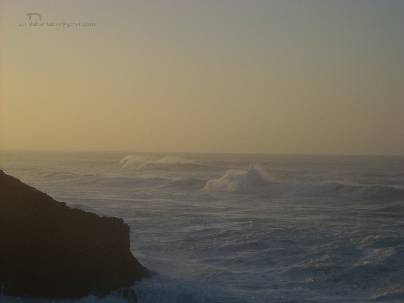
El Mar Cantábrico ingresa en la Ensenada de Noja superando la Punta de la Mesa, filtrando el oleaje, que se proyecta hacia la línea de costa. Recibe Helgueras olas que abren a izquierdas, con tamaño medio-alto, y alcanzan largo recorrido. El otoño, que registra mareas grandes, propicia olas de mayor tamaño. Desplazando las masas de agua sobre la ensenada, con suave pendiente y altura superior a los tres metros, aparecen tubos y navegaciones prolongadas. Existen otros picos de olas en la zona que abren a ambos lados y favorecen las maniobras.

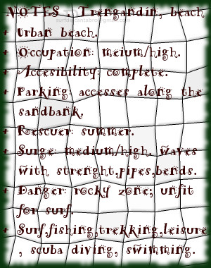
Trengandín, beach
![]() The beach of Trengandín is located in the municipality of Noja, on the oriental coast of Cantabria. It is one of the most extensive sandbanks of the Cantabrian coast with a length of 6000 meters and an average approximate width of 100 meters. Due to its dimensions, it contains several differentiated zones.
The beach of Trengandín is located in the municipality of Noja, on the oriental coast of Cantabria. It is one of the most extensive sandbanks of the Cantabrian coast with a length of 6000 meters and an average approximate width of 100 meters. Due to its dimensions, it contains several differentiated zones.
The first part of the beach, placed on urban zone of the villa, has a curved and irregular form. Its waters replete with sharp rocks form an spectacular landscape in low tide. It is an area adapted for the leisure, swimming, scuba diving, not being suitable to practise surf, since the rocky formations flood the zone and stand out over the water. The following section that begins in the Neighborhood of Helgueras and runs parallel to the Mounts of Mijedo, receives the Helgueras’s beach name. Occupied up to the half of the tour by rocks that disappear up to finding the second free and clean area of obstacles for the practice of the surf. Its final part, next the Mount El Brusco, is known as El Brusco.
The Cantabrian Sea enters in the Inlet of Noja overcoming the Mesa Tip, filtering the surge, which is projected towards the line of coast. Helgueras receives waves that open to left side, with medium-high size, and reach crossed length. The autumn, which registers big tides, propitiates waves of major size. The movement of the water masses in the inlet, with soft earring and height superior to three meters, brings up pipes and long navigations. Other beaks of waves exist in the zone that open for both sides and propitiates the maneuvers.
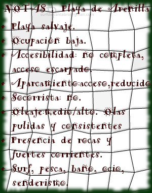
Playa de Arenilla. Galizano
![]() La Playa de Arenilla está situada en la localidad de Galizano, perteneciente al municipio de Ribamontán al Mar. Emplazada en la costa central de Cantabria se ubica entre las playas de Langre y Galizano. Es una pequeña cala que apenas supera los 100 metros de longitud, su anchura en bajamar es de 50 metros y queda totalmente cubierta con la marea alta.
La Playa de Arenilla está situada en la localidad de Galizano, perteneciente al municipio de Ribamontán al Mar. Emplazada en la costa central de Cantabria se ubica entre las playas de Langre y Galizano. Es una pequeña cala que apenas supera los 100 metros de longitud, su anchura en bajamar es de 50 metros y queda totalmente cubierta con la marea alta.
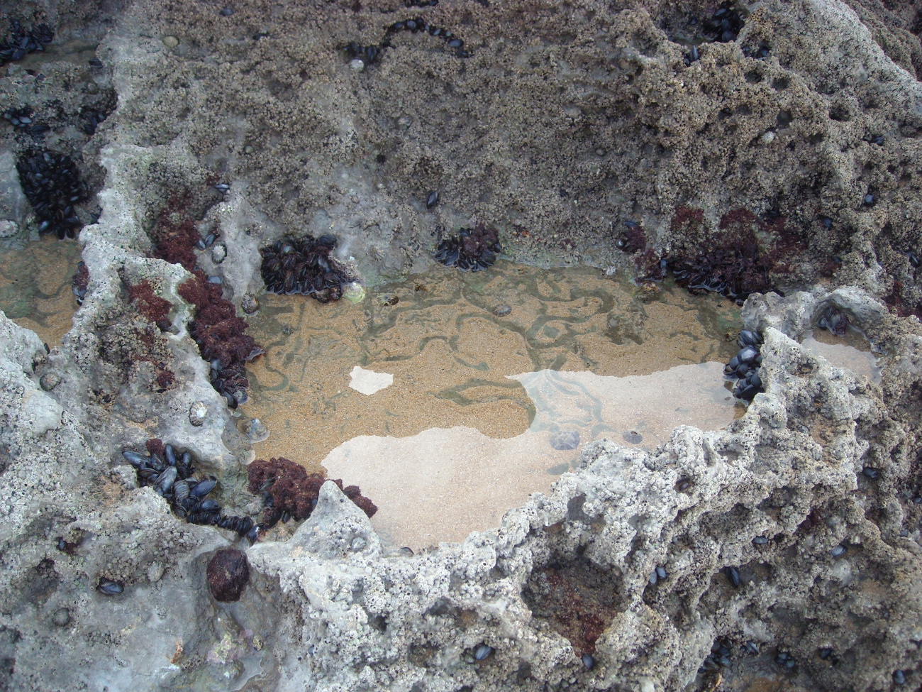
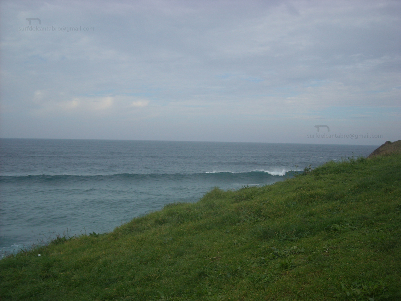
Arenilla en su mitad contigua al mar se compone de arenilla gruesa, con cuerpo, al contacto con el pie se mastican las pisadas. Su otra mitad, situada bajo el acantilado y con forma de U, está repleta de rocas apiladas, rozadas por el mar, que permiten sobre ellas un andar hábil. La parte derecha y superior del acantilado abre un sendero improvisado entre las rocas que llega hasta la playa de Galizano. El lado izquierdo y superior se comunica con la playa de Langre por medio de un camino agrícola. Su difícil localización y pedregoso acceso dan muestra de la naturaleza salvaje de la cala.
Las alas rocosas del acantilado amontonan rocas sueltas en su base, decorando su entrada al agua. La corriente fuerte exige buena condición física y la atención para evitar los laterales, con una pared frontal de roca estratificada en un lado y en el otro las corrientes circulares de la playa contigua; Langre. El frontal, situado en dirección decreciente hacia la cala, recibe una ola de derechas solo apta para surfers experimentados. La parte central, con su base profunda de roca y cubierta por gruesa arena metros por encima, crea una ola pulida, que abre a ambos lados y a veces solapa una ola de izquierdas tornando esta misma en derechas. De buena potencia y altura, traslada el agua limpia y con el ritmo adecuado para convertir la navegación en toda una experiencia que pueda reflejar por un instante la autenticidad del Mar Cantábrico y su costa.
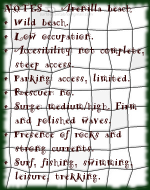
Arenilla beach. Galizano
![]() The Beach of Arenilla is placed in the locality of Galizano, belonging to the municipality of Ribamontán al Mar. Located on the central coast of Cantabria it is situated between the beaches of Langre and Galizano. It is an small cove that scarcely overcomes 100 meters of length, its width in low tide is 50 meters and remains totally covered with the high tide.
The Beach of Arenilla is placed in the locality of Galizano, belonging to the municipality of Ribamontán al Mar. Located on the central coast of Cantabria it is situated between the beaches of Langre and Galizano. It is an small cove that scarcely overcomes 100 meters of length, its width in low tide is 50 meters and remains totally covered with the high tide.
Arenila in its half contiguous to the Sea consists of thick sand, bodied, to the contact with the foot the steps are chewed. Its another half, placed under the cliff and with form of U, is replete with rocks piled up, rubbed by the sea, which allow on them one who walks skilfully. The right and top part of the cliff opens an improvised path between the rocks that comes up to Galizano’s beach. The left and top side communicates with Langre’s beach through an agricultural way. Its difficult location and stony access give sample of the wild nature of the cove.
The rocky wings of the cliff accumulate free rocks in their base, decorating its entry to the water. The strong currents demand good physical condition and the attention to avoid the wings, with a frontal wall of rock stratified in a side and in other one the circular currents of the contiguous beach; Langre. The frontal, placed in diminishing direction towards the cove, receives a right wave only suitable for experienced surfers. The central part, with its deep base of rock and covered by thick sand meters, creates a polished wave, which opens to both sides and, sometimes it overlaps a left wave turning itself into a right wave. Of good power and height, it moves the clean water and with the pace adapted to turn the navigation into the whole experience that could reflect for an instant the genuineness of the Cantabrian Sea and its coast.
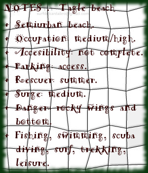
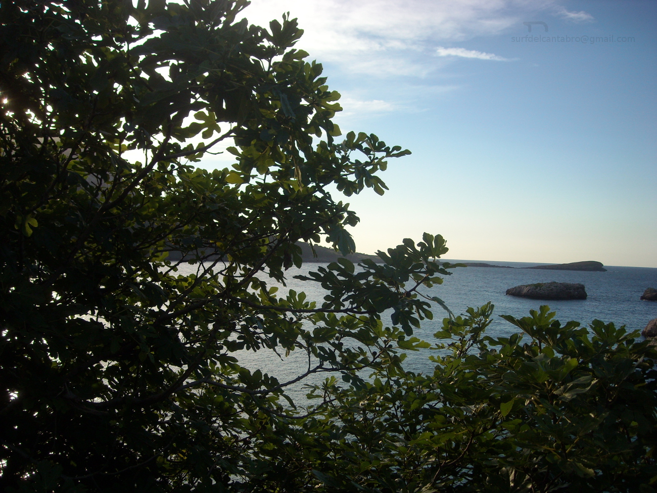
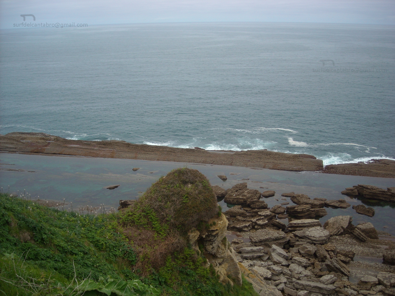
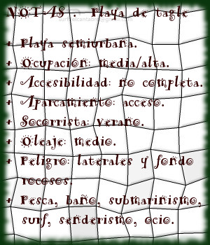
Tagle, playa
![]() La playa de Tagle, llamada Playa El Sable, se encuentra en la localidad de Tagle, perteneciente al municipio de Suances, en la costa occidental de Cantabria. El arenal de 200 metros de longitud y 50 metros de ancho, está precedido por un gran aparcamiento que es ocupado totalmente en la estación estival.
La playa de Tagle, llamada Playa El Sable, se encuentra en la localidad de Tagle, perteneciente al municipio de Suances, en la costa occidental de Cantabria. El arenal de 200 metros de longitud y 50 metros de ancho, está precedido por un gran aparcamiento que es ocupado totalmente en la estación estival.
La llegada a la playa de Tagle encuentra una cuesta con una pendiente suave, cada paso del caminante se ve ayudado por la inclinación. Poco a poco la zona aumenta su anchura para ir descubriendo la playa, sus laterales, las rocas dispersas dentro de sus aguas. El sonido del Mar Cantábrico, chocando con la Playa EL Sable, entona una melodía que expresa el carácter de la unión entre ambos. Música suave y atrayente ó violenta y natural, ambos estados registra la playa de Tagle.
Los laterales y fondo rocoso la convierten en una playa peligrosa para la práctica del surf. La zona hábil para navegar se encuentra alejada de la línea de costa, evitando las zonas rocosas y situada fuera de la ensenada que forma la playa con el entorno. Las rocas que restan en la zona constituyen la base de la prehistórica y ancestral costa. El efecto de la fuerza del oleaje y las grandes mareas han ido erosionando y afilando los acantilados que son los vestigios que ahora quedan, a modo de entorno rocoso.
Tagle, beach
![]() Tagle’s beach, also called Beach El Sable, is in the locality of Tagle, belonging to the municipality of Suances, on the western coast of Cantabria. The sandbank of 200 meters of length and 50 meters of width, is preceded by a great parking which is totally occupied on the summer station.
Tagle’s beach, also called Beach El Sable, is in the locality of Tagle, belonging to the municipality of Suances, on the western coast of Cantabria. The sandbank of 200 meters of length and 50 meters of width, is preceded by a great parking which is totally occupied on the summer station.
The arrival to Tagle’s beach finds a slope with a soft slope, every step of the wayfarer meets helped by the inclination. Little by little the zone increases its width to discover the beach, its wings, the dispersed rocks inside its waters. The sound of the Cantabrian Sea, shocking the Beach El Sable, intones a melody that expresses the character of the union between them. Soft and attractive music or violent and natural, both conditions are register in Tagle’s beach.
The wings and bottom turn her into a dangerous beach for the practice of the surf. The skilful zone to sail is removed from the coast line, avoiding the rocky areas and placed out of the inlet that forms the beach with the environment. The rocks that remain in the zone constitute the base of the prehistoric and ancient coast. The effect of the force of the surge and the big tides have been eroding and sharpening the cliffs that are the vestiges that now stay, like rocky environment.