Playa de Los Locos, Localización

Icono Español. Icon Spanish. Playa de Los Locos La Playa de Los Locos está localizada en el municipio de Suances. Se puede llegar a Los Locos desde: Oviedo, Palencia, Santander ó Bilbao. Todos los trayectos son por autovía, finalizando el viaje por carretera nacional. Cualquier otro punto de origen comparte o atraviesa uno o varios de los puntos de partida anteriores.

Beach of Los Locos, localization

Icono Inglés. Icon English. Beach Los Locos Los Locos Beach is located in the municipality of Suances. You can get to Los Locos Beach from: Oviedo, Palencia, Santander or Bilbao. All trips are by motorway, ending the trip through the national road. All other departure points share one or several of the previous points of origin.

Icono Español-Inglés. Icon Spanish-English. Playa de Los Locos. Beach Los Locos Localización/Localization

Oviedo, Los Locos: LocalizationPalencia, Los Locos: LocalizationBilbao, Los Locos: LocalizationSantander, Los Locos: localization

Icon close Sponsor

Share

La Vaca, Localización

Icono Español. Icon Spanish La Vaca está localizada en el barrio de Monte-Corbanera, situado en la costa norte de la ciudad de Santander. Su localización es complicada, ya que este spot no se encuentra registrado en las guías de viajes y mapas. Los enlaces que se muestran más abajo finalizan su trayecto en el Barrio Monte-Corbanera. De allí cogemos el desvío hacia el Instituto Español de Oceanografía (derecha), que cuenta en su parte trasera, con una pequeña zona a modo de parking. En la zona hay varios carteles que indican la dirección hacia el IEO. Una vez en el aparcamiento, vemos la entrada a la Playa del Bocal. La siguiente cala, situada a la derecha, es: La Vaca. Se muestran como puntos de partida Oviedo, Palencia, Santander y Bilbao, el resto de orígenes comparte el final del trayecto con esas localizaciones.

La Vaca, Localization

Icono Inglés. Icon English La Vaca is located in the neighborhood of Monte-Corbanera , placed on the north coast of the city of Santander. Its location is complicated, because this spot is not registered in the travel guides and maps. The links shown below end the journey at the neighborhood Monte-Corbanera . From there you have to take the detour to the Spanish Institute of Oceanography (IEO) (right), which has in his rear, a small area by way of parking. In the zone there are several signs indicating the direction toward the IEO. Once in the parking lot, we see the entrance to the Beach of EL Bocal. The next cove, situated to the right, is: La Vaca. Are shown as points of departure Oviedo, Palencia, Santander and Bilbao, the rest of origins shares the end of the journey with these localizations.

Icono Español-Inglés. Icon Spanish-English Localización/Localization

Oviedo, La Vaca: LocalizationPalencia, La Vaca: LocalizationBilbao, La Vaca: LocalizationSantander, La Vaca: localization

Icon close Sponsor

Share

La Maruca, Localización

Icono Español. Icon Spanish La Playa de La Maruca está situada en la ciudad de Santander. Es una playa semiurbana emplazada en la costa norte de la ciudad. Compuesta por rocas y arena, se situa entre acantilados que reducen su tamaño hasta desembocar en el paseo marítimo que da acceso a la playa. A la Maruca se puede llegar desde el centro de Santander o por autovía (S-20). Se muestra a continuación como puntos de partida Santander y Bilbao. El resto de orígenes finalizarán en la ruta que enlaza Santander con La Maruca o en la parte final del trayecto que se inicia en Bilbao.

La Maruca, Localization

Icono Inglés. Icon English The Beach of «La Maruca» is located in the city of Santander. It is a semi-urban beach located on the north coast of the city. It is Composed of rocks and sand, is located between cliffs that reduce its size up to lead to the promenade that gives access to the beach. «La Maruca» can be reached from the center of Santander or through the highway (S-20). Shown below as starting points Santander and Bilbao. The rest of origins will finish in the route that connects Santander with «La Maruca» or in the final part of the journey that starts in Bilbao.

Icono Español-Inglés. Icon Spanish-English Localización/Localization

Oviedo, La Maruca: LocalizationPalencia. La Maruca: LocalizationBilbao, La Maruca: LocalizationSantander, LaMaruca: localization

Icon close Sponsor

Share

Playa de Valdearenas, Liencres; Localización

Icono Español. Icon Spanish La Playa de Valdearenas está situada en la localidad de Liencres, perteneciente al municipio de Piélagos. Esta playa también se conoce con el nombre de su localidad, Liencres. A la Playa de Valdearenas se puede llegar desde Oviedo, Palencia, Santander y Bilbao; como puntos de partida, todos los demás orígenes atraviesan por uno o varios de estos puntos. La llegada a las playas de Liencres no es está indicada en las guías oficiales, es por ello que la ruta finaliza en el Barrio Callejo de liencres. Llegando desde Oviedo encontramos la entrada a las playas antes de llegar al Barrio Callejo. Desde los demás puntos de partida debemos continuar la carratera hasta llegar al Parque natural de las Dunas de Liencres. La entrada esta bien señalizada.

Valdearenas Beach, Liencres; Localization

Icono Inglés. Icon English Valdearenas Beach is located in the town of Liencres, belonging to the municipality of Piélagos. This beach is also known by the name of its locality, Liencres. To the beach of Valdearenas can be reached from Oviedo, Palencia, Santander and Bilbao; as points of departure, all other origins run through one or more of these points. The arrival to Liencres’s beaches is not is indicated in the official guides, is for it that the route finishes in the Neighborhood Callejo of liencres. Coming from Oviedo we find the entry to the beaches before arriving to the Neighborhood Callejo. From other points of item we must continue the road up to coming to the Nature Reserve of Liencres’s Dunes. The entry is well indicated.

Icono Español-Inglés. Icon Spanish-English Localización/Localization

Oviedo, Playa de Valdearenas; Liencres: LocalizationPalencia, Playa de Valdearenas; Liencres : LocalizationBilbao, Playa de Valdearenas; Liencres: LocalizationSantander, Playa de Valdearenas; Liencres; Localization

Share

De Langre a Santa Marina. Ruta de senderismo

Icono Español. Icon Spanish La Playa de Langre esta ubicada en el municipio de Langre. Su entrada principal , situada más a la izquierda; posee una carretera asfaltada que termina en un mirador natural con una barandilla de madera. Desde este lugar se contempla la playa de Langre en su totalidad y el camino que la costa Cántabrica traza entre la roca y el mar. Galizano detrás, y al fondo, a lo lejos se intuye el Cabo Quintres.

A mano izquierda de este mirador comienza un pequeñito sendero. Dibujado sobre la hierba por los pasos que lo transitan. Transcurre paralelo al borde de los acantilados que hay entre la Playa de Langre y la Isla de Santa Marina a lo largo de 3,5 km. Ligeras cuestas y suaves descensos amenizan el trayecto que se desarrolla dentro de un paisaje que impregna el ambiente como una música ambiental. Conforme avanzamos, va apareciendo la ciudad de Santander y su bahía, proporcionando diferentes perspectivas de una misma postal.

En la parte central del recorrido se encuentra el Mirador de Llaranza. Con una extensión aproximada de 1 km, cuenta en su base; a nivel del mar, con unas piscinas naturales de la misma longitud. Formadas sobre una plataforma de abrasión. Son una fotografía de irregular y natural figura, tallada por el Mar Cantábrico a lo largo de los siglos. Este punto es un buen lugar para hacer una parada y alcanzar la paz, por medio la contemplación de la belleza que la naturaleza muestra.

Al final de la ruta nos encontramos con la Isla de Santa Marina. La mayor de las islas de Cantabria, con una extensión de 18,5 hectáreas. Separada de la línea de costa por apenas 15 metros en su parte más cercana a ella. Constituye en sí misma y en el entorno en el que se ubica un emplazamiento único y abundante en estímulos.

Mirando al horizonteen cualquier punto del recorrido, una sensación de libertad empapa el espíritu. Unas sonrisas aparecen al intentar distinguir, a lo lejos, la fina e indefinida línea que separa el Mar Cantábrico del cielo.

Consejo : tener precaución.

Langre, Santa Marina. Trekking route

Icono Inglés. Icon English The Langre Beach is located in the municipality of Langre. Its main entrance, located more to the left; it has a paved road that ends at a lookout point with a natural wood handrail. From this place you can see the Langre beach in its entirety and the way that the Cantabrian coast draws between the rock and the sea. Galizano behind, and the fund, in the distance one perceives the Cape Quintres.

To left hand of this lookout a tiny footpath begins. Drawn on the grass for the steps that journey have caused. Runs parallel to the edge of the cliffs that exist between the Beach of Langre and the Island of Santa Marina. Its length has 3,5 km. Medium slopes and soft descents liven up the trajectory that develops inside a scenery that impregnates the ambience as an environmental music. As we advance, appears the city of Santander and its bay, providing different perspectives of the same postcard.

In the central part of the tour is the lookout of Llaranza. With an approximate length of 1 km, has in its base; at sea level, some natural pools of the same length. Formed on an abrasion platform. They are a picture of irregular and natural figure, carved by the Cantabrian Sea throughout the centuries. This point is a good place to stop and achieve peace, through the contemplation of the beauty that nature shows.

At the end of the path we found with the island of Santa Marina. The largest of the islands of Cantabria, with an extension of 18.5 hectares. Separated from the coastline by a mere 15 feet at its closest to it. It is in itself and in the environment in which it is located a unique location and abundant in stimuli.

Looking at the horizon in anywhere along the route , a freedom sensation soaks the spirit. A few smiles appear on having tried to distinguish, in the distance, the thin and indefinite line that separates the Cantabrican Sea of the sky.

Advice: take caution.

Separador. DividerIcono Español-Inglés. Icon Spanish-EnglishLangre,Santa Marina: LlaranzaIcono separador. Icon divider

Icon close Sponsor

Share

Playa de Mataleñas. Una cala dentro de Santander

Icono Español. Icon Spanish La playa de Mataleñas está situada en la ciudad de Santander. Se encuentra emplazada entre Cabo Menor y Cabo Mayor. Su arenal tiene 125 metros de longitud y una anchura aproximada de 40 metros. Flanqueada por acantilados que esculpe el Mar Cantábrico, estas barreras naturales acompañan a la cala 250 metros antes de llegar a mar abierta.

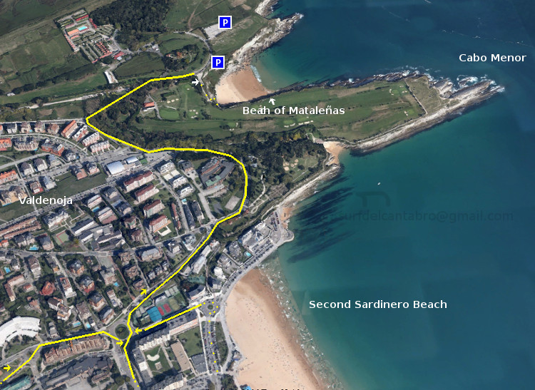
Localización : una vez situados en la ciudad de Santander, nos dirigiremos hacia la Segunda Playa del Sardinero. Desde allí cogemos dirección al Faro de Cabo Mayor. Pasado el Barrio de Valdenoja, subiendo la cuesta, al final hay un desvío a mano derecha que da acceso a un mirador desde donde contemplar parte de la Bahía de Santander y la Playa de Mataleñas.

Acceso : cuenta con un pequeño parking cercano a su escalinata de entrada. Se baja a la playa a través de las escaleras que traducen una altitud de 40 metros, hasta amenizar a nivel del mar, en un pequeño balcón abarandillado que nos presenta la cala de una forma singular.

La playa de Mataleñas es apta para el baño, ir de comida, pesca a surfcasting y el submarinismo. Sus aguas limpias y de color azul verdoso traslucen parte del paisaje submarino que puede encontrarse al bucear en la zona. Lubinas, doradas, perlas, cabras, cabrachos y agujones son algunas de las especies de peces que vamos a encontrar. Acompañados de crustáceos y algas rodeados por cuevas y roca tallada por el Cantábrico.

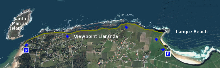
La playa de Mataleñas se comunica con los siguientes puntos : Faro de Cabo Mayor, Cabo Menor, Parque de Mataleñas, recorrido periférico del Campo de Golf de Mataleñas, El Sardinero. Es por ello que se convierte en una zona ideal para realizar rutas de senderismo con diversos recorridos.

Separador. DividerIcono Español-Inglés. Icon Spanish-Englishaccess, localization: mataleñas beachIcono separador. Icon divider

Beach of Mataleñas. A cove within Santander

Icono Inglés. Icon English The Beach of Mataleñas is located in the city of Santander. It is placed between Cabo Menor and Cabo Mayor. Its arenal has 125 meters in length and a width of approximately 40 meters. Flanked by cliffs that sculpts the Cantabrian Sea, these natural barriers accompany the cove through 250 meters before arriving to open sea.

Location : once placed in the city of Santander, we go toward the Second Sardinero Beach. From there take the road to the Lighthouse Cabo Mayor. Then the last neighborhood, Valdenoja. Just up the hill, at the end, there is a diversion on the right hand which gives access to a vantage point from where you can watch part of the Santander Bay and the Beach of Mataleñas.

Access : account with a small parking close to its entrance staircase. You can arrive to the beach through the stairs. That translate an altitude from 40 meters to sea level. At the end, an small balcony balustraded presented to us the cove in a singular way.

The beach Mataleñas is suitable for the bathroom, picnic, surfcasting and scuba diving. Its clean waters and greenish blue color show part of the underwater scenery that can be found when diving in the area. Sea Bass, golden, pearls, goats, scorpion fish and agujones are some of the species of fish that we are going to find. Accompanied by crustaceans and algae surrounded by caves and rock carved by the Cantabrian Sea.

The beach of Mataleñas communicates with the following points: Lighthouse Cape Mayor, Cape Menor, Mataleñas’s Park, peripheral road of Mataleñas’s Golf course, The Sardinero. It is for it that turns into an ideal zone to realize routes of trekking with diverse tours.

Icon close Sponsor

Share

Playa de los Peligros: Windsurf, Kitesurf

Icono Español. Icon Spanish La Playa de Los Peligros está situada en la ciudad de Santander, junto a la Playa de la Magdalena.

Para llegar a Los Peligros hay dos vías. La primera desde la Calle Castelar cogiendo el desvío a mano derecha para ir al Palacio de Festivales de Cantabria. Después continuamos la carretera hasta el final. La segunda opción desde la Avenida Reina Victoria, viniendo de la península de la Magdalena. Al Final de la avenida, girando a la izquierda se accede a parte del recorrido anterior.

Los Peligros es una playa de arena blanca y fina. Sus aguas son tranquilas y sin oleaje. Es adecuada para el baño, el disfrute del mar y su arenal. Cuenta con un parking amplio que se suele llenar en verano. El paseo hasta la playa constituye en sí mismo un pequeño viaje. Al tiempo que se ve una parte portuaria antigua de la ciudad se visualiza la Bahía de Santander y un puzzle montañoso al fondo.

Los días de viento esta sencilla zona se convierte en un circuito deportivo frecuentado por velas y cometas de winsurf y kitesurf. Desde la playa se entra a estas autopistas virtuales que cuentan con suficiente espacio para disfrutar de estas modalidades de surf. En este lugar generalmente el viento está presente en mayor o menor grado. Convirtiendo a la playa de Los Peligros en un lugar ideal para la práctica del windsurf y kitesurf.

Playa de Los Peligros: windsurf, kitesurf

Icono Inglés. Icon English Los Peligros Beach is located in the city of Santander, next to the Magdalena Beach.

To reach Los Peligros there are two ways. The first from the Castelar Street. Taking the detour to the right to go to the Palacio de Festivales de Cantabria. Then we continue the road to the end. The second option from the Avenida Reina Victoria, coming from the peninsula of la Magdalena. At the end of the avenue, turning to the left to access part of the above route.

Los Peligros is a beach of fine and white sand. Its waters are calm and without waves. It is suitable for the swiming, the enjoyment of the sea and its arenal. Account with an ample car parking which is usually fill in summer. The walk down to the beach is a small trip. At the same time that we see a part of the ancient port part of the city is displayed the Santander Bay and a puzzle of mountains in the background.

The windy days this area becomes a sporting circuit frequented by sails and kites of windsurfing and kitesurfing. From the beach you access to several and endless virtual highways that have enough space to enjoy these modalities of surfing. The wind is usually present to a greater or lesser degree in this zone. Turning to Los Peligros Beach in an ideal place for windsurfing and kitesurfing.

Separador. DividerIcono Español-Inglés. Icon Spanish-EnglishLos PeligrosIcono separador. Icon divider
Icon close Sponsor

Share

El sardinero, localización

Icono Español. Icon Spanish Las dos playas de El Sardinero están situadas en la ciudad de Santander. Ambas playas reciben el mismo nombre y se las conoce como: Primera Playa del Sardinero y Segunda Playa del Sardinero. Se accede a El Sardinero por múltiples vías una vez situados en Santander. Se puede llegar a Santander desde cualquier punto de la geografía española, compartiendo todos los trayectos cuatro localizaciones que pueden ser de partida o de transito. Estas son : Oviedo, Palencia, Bilbao y Burgos. Las tres primeros por autovía y la último por carretera nacional; atravesando el Puerto del Escudo. Ya emplazados en Santander o cercanías, hay dos opciones. Desde el oeste utilizando la S-20, llamada la Autovía del Sardinero. La otra opción es por medio de la S-10, atravesando la ciudad; pues la configuración de Santander se orienta hacia sus playas.

Nota: el trayecto por la S-20 ha sido selecionado con origen en el Barrio de La Albericia, para poder poder visualizar la autovía. Se puede partir desde cualquier otro punto que conduzca a la S-20.

El Sardinero, Localization

Icono Inglés. Icon English The two beaches of «El Sardinero» are located in the city of Santander. Both places are given the same name and are known as: First Sardinero Beach and Second Sardinero Beach. El Sardinero is accessed by multiple pathways once you have been located in Santander. You can reach Santander from any point of the Spanish geography. All the journeys share one of four possible locations that may be of heading or transit. These are: Oviedo, Palencia, Bilbao and Burgos. The first three by motorway and the last by national road; going through the port of «El Escudo«. When you already are in Santander or vicinity you can choose between two options. From the west using the S-20, called the Highway of «El Sardinero». The other option is through the S-10, which passes through the city. The configuration of Santander is oriented toward its beaches.

Note: the journey by the S-20 has been selected with origin in the district of La Albericia, in order to be able to display the dual carriageway. You can travel from any other point that is conected to the S-20.

Icono Español-Inglés. Icon Spanish-English Localización/Localization

Oviedo, El Sardinero: LocalizationPalencia, El Sardinero: LocalizationSantander, El Sardinero; S-10 : LocalizationBilbao, El Sardinero : Localization

Icon close Sponsor

Share

Galizano, localización

Icono Español. Icon Spanish La Playa de Galizano se encuentra en la localidad de Galizano, que pertenece al municipio de Ribamontán al Mar. Desde Galizano se accede a la siguientes playas: Playa de Arenilla y Playa de Galizano. La primera de ellas es una pequeña cala de difícil acceso y rodeada por acantilados sobre mar abierta. Apta para el baño con precaución, pues tiene fuertes corrientes y puede ser peligrosa, es ideal para el disfrute apartado de la naturaleza. La segunda playa es de mayor extensión y presenta un fuerte oleaje, característico de esta parte de la costa cántabra. Buenas olas y un entorno que exige cierto nivel en la práctica del surf. Se puede llegar hasta la Playa de Galizano desde Oviedo, Palencia, Santander o Bilbao. Comenzando el viaje por autovía y finalizando por carretera nacional. Una vez situados en Galizano el camino de la playa esta bien indicado.

Galizano Beach, Localization

Icono Inglés. Icon English Galizano beach is located in the town of Galizano, which belongs to the municipality of «Ribamontán al Mar«. Galizano gives access to the following beaches: «Arenilla» beach and Galizano beach. The first of these is a small cove of difficult access and surrounded by cliffs on open sea. Suitable for bathing with caution, because it has strong currents and can be dangerous, it is ideal for the enjoyment of nature. The second Beach is largest and presents a strong swell, characteristic of this part of the Cantabrian coast. Good waves and an environment that requires a certain level in the practice of surfing. You can reach the beach of Galizano from Oviedo, Palencia, Santander or Bilbao. Starting the journey by motorway and ending by national road. Once placed in Galizano the way of the beach is well signposted .

Icono Español-Inglés. Icon Spanish-English Localización/Localization

Oviedo, Galizano: LocalizationPalencia, Galizano: LocalizationBilbao, Galizano: LocalizationSantander, Galizano: Localization

Icon close Sponsor

Share

El Brusco, localización

Icono Español. Icon Spanish «El Brusco» está situado al final de la playa de Trengandín, perteneciente al municipio de Noja. La segunda mitad de la playa; debido a que su acceso se realiza por el barrio de Helgueras, recibe el nombre de playa de Helgueras. Al final de la playa de Helgueras se encuentra el Monte el Brusco, de ahí que esta zona final de la playa se conozca con el mismo nombre: El Brusco. Se puede llegar al Brusco desde Oviedo, Palencia, Santander o desde Bilbao. Cualquier viaje con distinto origen comparte final de recorrido con el trayecto que se hace desde los puntos de partida anteriores. Comenzando por autovía y finalizando por carretera nacional.

El Brusco, Localization

Icono Inglés. Icon English «El Brusco» is located at the end of Tregandín beach, belonging to the municipality of Noja. The second half of the beach; due to its access is performed by the neighborhood of Helgueras, receives the name of Helgueras beach. At the end of the Helgueras beach is The Brusco mountain, so this area is known with the same name. You can reach «El Brusco» from Oviedo, Palencia, Santander or Bilbao. Any trip with another origin shares the end of travel with the journey that is made from the above starting points. Starting by motorway and ending by national road.

Icono Español-Inglés. Icon Spanish-English Localización/Localization

Oviedo, El Brusco: LocalizationPalencia, El Brusco: LocalizationBilbao, El Brusco: localizationSantander, EL Brusco: Localization

Icon close Sponsor

Share