
Langre, playa
![]() La playa de Langre se ubica en la localidad de Langre, perteneciente al municipio de Ribamontán al mar. Esta localidad costera, se encuentra con el mar a través de sus acantilados que se extienden varios kilómetros. El arenal tiene una longitud aproximada de 800 metros y una anchura media de 60 metros. A su espalda un acantilado, con forma de media luna achatada y de 25 metros de altura, la contiene en su totalidad. En sus alas, la línea de costa entra en el mar a modo de cabo, completando un entorno único de singular belleza. A la izquierda la Punta de Langre protege la ensenada, a la derecha la Punta Rodico delimita su extensión final. La fisonomía del lugar acota la playa de Langre y filtra el oleaje parcialmente, pues no pierde el Mar Cantábrico su naturaleza salvaje; sino que se transforma y renace. Existen así olas diferentes en todo el área, conservando una zona de aguas tranquilas en su lado izquierdo, bajo la protección del acantilado.
La playa de Langre se ubica en la localidad de Langre, perteneciente al municipio de Ribamontán al mar. Esta localidad costera, se encuentra con el mar a través de sus acantilados que se extienden varios kilómetros. El arenal tiene una longitud aproximada de 800 metros y una anchura media de 60 metros. A su espalda un acantilado, con forma de media luna achatada y de 25 metros de altura, la contiene en su totalidad. En sus alas, la línea de costa entra en el mar a modo de cabo, completando un entorno único de singular belleza. A la izquierda la Punta de Langre protege la ensenada, a la derecha la Punta Rodico delimita su extensión final. La fisonomía del lugar acota la playa de Langre y filtra el oleaje parcialmente, pues no pierde el Mar Cantábrico su naturaleza salvaje; sino que se transforma y renace. Existen así olas diferentes en todo el área, conservando una zona de aguas tranquilas en su lado izquierdo, bajo la protección del acantilado.

Langre, beach
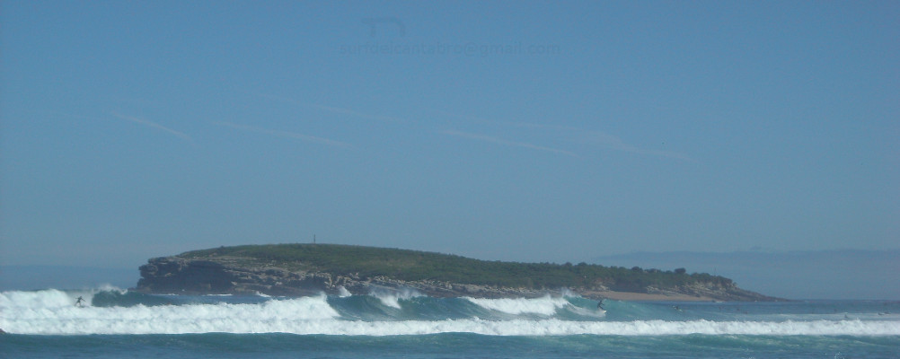
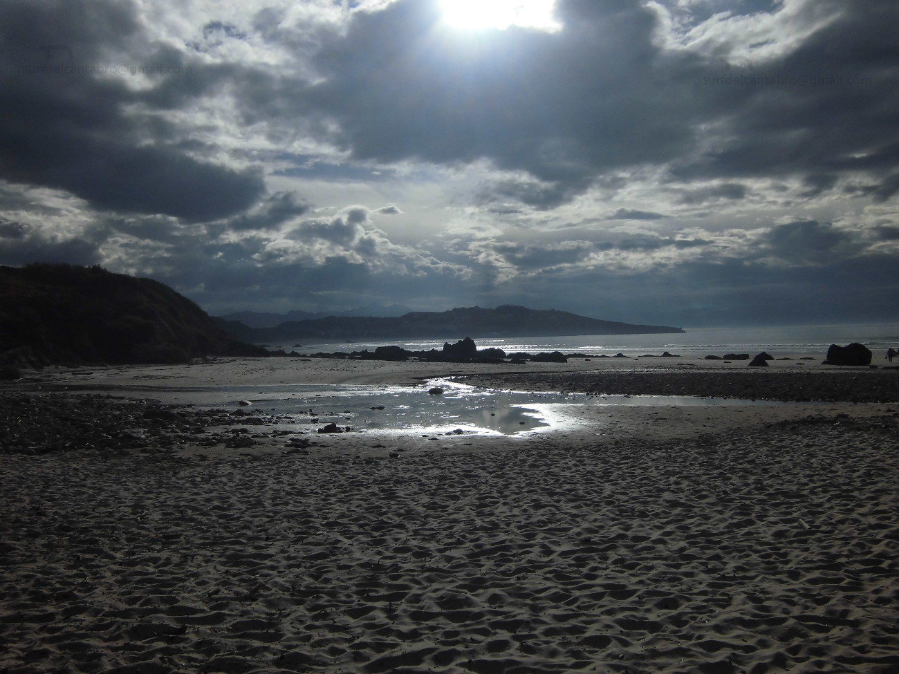
![]() The beach of Langre is located in the locality of Langre, belonging to the municipality of Ribamontán al Mar. This coastal locality, meets the sea across its cliffs that several kilometres spread. The sandbank has an approximate length of 800 meters and a width of 60 meters. To its back, the cliff with form of flattened half moon and of 25 meters of height, contains it. In its wings, the line of coast enters in the sea as a cape, completing an special environment of singular beauty. To the left side the Tip of Langre protects the inlet, to the right the Rodico Tip delimits its end extension. The local physiognomy annotates Langre’s beach and leaks the surge partially, because the Cantabrian sea does not lose its wild nature; but it is transformed and reborn. So different waves exist in the area, preserving a zone of calm waters in its left side, under the protection of the cliff.
The beach of Langre is located in the locality of Langre, belonging to the municipality of Ribamontán al Mar. This coastal locality, meets the sea across its cliffs that several kilometres spread. The sandbank has an approximate length of 800 meters and a width of 60 meters. To its back, the cliff with form of flattened half moon and of 25 meters of height, contains it. In its wings, the line of coast enters in the sea as a cape, completing an special environment of singular beauty. To the left side the Tip of Langre protects the inlet, to the right the Rodico Tip delimits its end extension. The local physiognomy annotates Langre’s beach and leaks the surge partially, because the Cantabrian sea does not lose its wild nature; but it is transformed and reborn. So different waves exist in the area, preserving a zone of calm waters in its left side, under the protection of the cliff.
Berria, playa
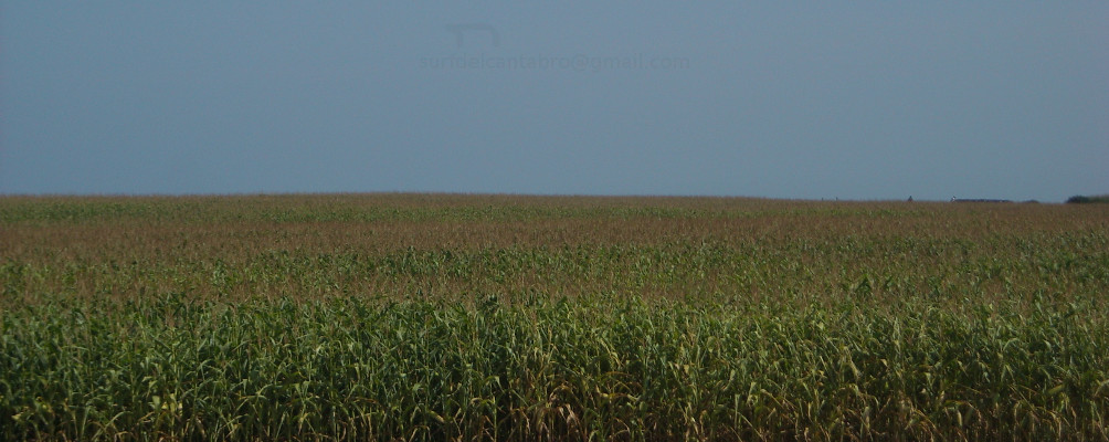
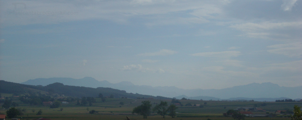
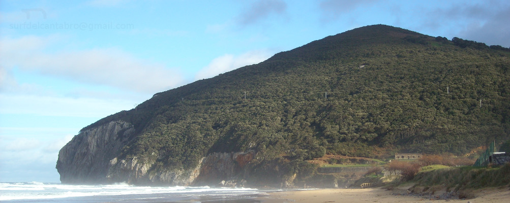
![]() La playa de Berria está ubicada en la zona noroeste del municipio de Santoña. Emplazada entre montes y marisma, mira de frente al Mar Cantábrico. Este gran arenal de 2200 metros de longitud y 150 metros de anchura se encuentra acotado desde el oeste por el monte EL Brusco, desde el este por el macizo del Buciero. Ambos montes impregnan con sus rocas los costados del arenal, transportando al visitante a un tiempo remoto, salvaje y natural. Al sur de la playa hay una basta extensión de 6678 hectáreas que componen El Parque Natural de las Marismas de Santoña, Victoria y Joyel.
La playa de Berria está ubicada en la zona noroeste del municipio de Santoña. Emplazada entre montes y marisma, mira de frente al Mar Cantábrico. Este gran arenal de 2200 metros de longitud y 150 metros de anchura se encuentra acotado desde el oeste por el monte EL Brusco, desde el este por el macizo del Buciero. Ambos montes impregnan con sus rocas los costados del arenal, transportando al visitante a un tiempo remoto, salvaje y natural. Al sur de la playa hay una basta extensión de 6678 hectáreas que componen El Parque Natural de las Marismas de Santoña, Victoria y Joyel.
Berria se ha ido formando a lo largo de los siglos. En la antigüedad Santoña era una isla. Rodeada por el mar, la acumulación de sedimentos en los flancos de la actual playa debido a las corrientes entrantes y salientes, junto con la acción del viento terminaron cerrando la salida del agua. La posterior aparición de formaciones dunáres crearon un istmo que dió origen a la actual playa de Berria.
Berria, beach
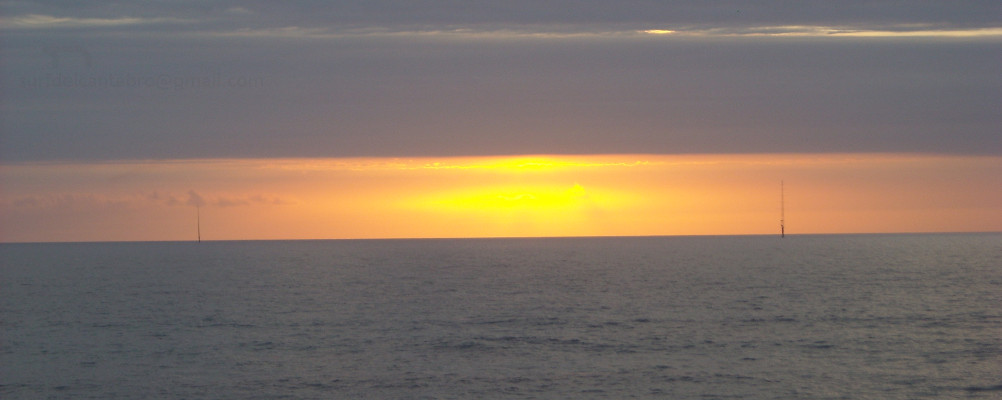
![]() The beach of Berria is located in the northwest zone of the municipality of Santoña. Placed between mounts and marsh, it looks to the Cantabrian Sea. This great sandbank of 2200 meters of length and 150 meters of width is drawn from the west by the mount El Bursco, from the west by the clump of the Buciero. Both mountains impregnate with its rocks the sides of the sandbank, transporting the visitor to a remote, wild and natural time. To the south of the beach there is an extension of 6678 hectares that compose The Nature reserve of Santoña’s Marshes, Victory and Joyel.
The beach of Berria is located in the northwest zone of the municipality of Santoña. Placed between mounts and marsh, it looks to the Cantabrian Sea. This great sandbank of 2200 meters of length and 150 meters of width is drawn from the west by the mount El Bursco, from the west by the clump of the Buciero. Both mountains impregnate with its rocks the sides of the sandbank, transporting the visitor to a remote, wild and natural time. To the south of the beach there is an extension of 6678 hectares that compose The Nature reserve of Santoña’s Marshes, Victory and Joyel.
Berria has been formed throughout the centuries. In the antiquity, Santoña was an island. Surrounded by the sea, the accumulation of sediments in the flanks of the current beach due to the entry and exit currents, together with the action of the wind; them ended up by closing the exit of the water. The later appearance of dunes and vegetation, created an isthmus that gave origin to Berria’s current beach.
Playa El Pedrero, acceso
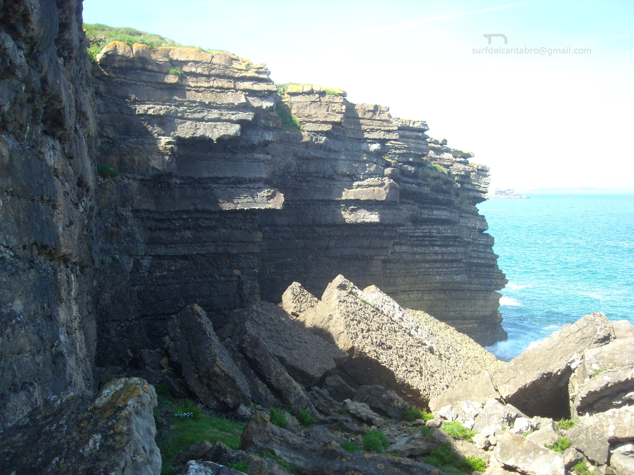
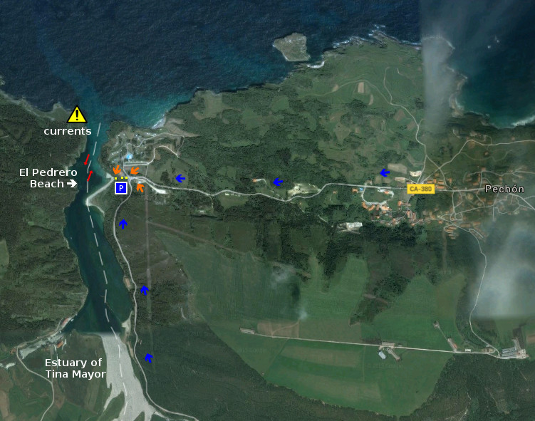
![]() La Playa del Pedrero está situada en la localidad de Pechón, perteneciente al municipio de Val de san Vicente. Es la playa más occidental de Cantabria. Ubicada en la desembocadura de la Ría de Tina Mayor, es apta para el baño y el ocio. Es una zona con presencia de corrientes. Existe un pequeño aparcamiento desde el cual se llega a una pequeña senda, con escaleras, que conducen directamente a la playa.
La Playa del Pedrero está situada en la localidad de Pechón, perteneciente al municipio de Val de san Vicente. Es la playa más occidental de Cantabria. Ubicada en la desembocadura de la Ría de Tina Mayor, es apta para el baño y el ocio. Es una zona con presencia de corrientes. Existe un pequeño aparcamiento desde el cual se llega a una pequeña senda, con escaleras, que conducen directamente a la playa.
El Pedrero Beach, access
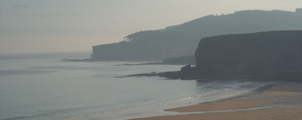
![]() The Beach of El Pedrero is placed in the locality of Pechón, belonging to the municipality of Val de san Vicente . It is the most western beach of Cantabria. Located in the river mouth of the Estuary of Tina Mayor , it is suitable for the swiming and the leisure. It is a zone with currents . There exists an small parking from which you will arrive to one way, with stairs, which lead directly to the beach.
The Beach of El Pedrero is placed in the locality of Pechón, belonging to the municipality of Val de san Vicente . It is the most western beach of Cantabria. Located in the river mouth of the Estuary of Tina Mayor , it is suitable for the swiming and the leisure. It is a zone with currents . There exists an small parking from which you will arrive to one way, with stairs, which lead directly to the beach.
 Acceso/Access
Playa El Pedrero, localización
![]() La playa El Pedrero se encuentra en la localidad de Pechón, perteneciente al municipio de Val de San Vicente; en la costa occidental de Cantabria. La ruta oficial termina en el pueblo de Pechón. Desde allí nos encaminamos por la carretera nacional CA-380 hacia el Camping, situado a la entrada de la playa. Para los viajes cuyo origen sea en el oeste, Oviedo, el Camping y la playa aparecerán antes del final del trayecto y del centro de la localidad. Se muestran a continuación como puntos de partida: Oviedo, Palencia, Santander y Bilbao. Comenzando el viaje por autovía y finalizando el recorrido por la misma carretera nacional en todos los trayectos.
La playa El Pedrero se encuentra en la localidad de Pechón, perteneciente al municipio de Val de San Vicente; en la costa occidental de Cantabria. La ruta oficial termina en el pueblo de Pechón. Desde allí nos encaminamos por la carretera nacional CA-380 hacia el Camping, situado a la entrada de la playa. Para los viajes cuyo origen sea en el oeste, Oviedo, el Camping y la playa aparecerán antes del final del trayecto y del centro de la localidad. Se muestran a continuación como puntos de partida: Oviedo, Palencia, Santander y Bilbao. Comenzando el viaje por autovía y finalizando el recorrido por la misma carretera nacional en todos los trayectos.
Beach El Pedrero, localization
![]() The beach of El Pedrero is in the locality of Pechón, belonging to the municipality of Val de San Vicente; on the western coast of Cantabria. The route finishes in the town of Pechón. From there, we have to go for the national road CA-380 towards the Camping; which is placed to the entry of the beach. For the travels which origin is in the west, Oviedo, the Camping and the beach will appear before the end of the tour and of the center of the locality. Shown below as starting points: Oviedo , Palencia , Santander and Bilbao . Beginning the trip for motorway and finishing the tour for the same national road in all the options.
The beach of El Pedrero is in the locality of Pechón, belonging to the municipality of Val de San Vicente; on the western coast of Cantabria. The route finishes in the town of Pechón. From there, we have to go for the national road CA-380 towards the Camping; which is placed to the entry of the beach. For the travels which origin is in the west, Oviedo, the Camping and the beach will appear before the end of the tour and of the center of the locality. Shown below as starting points: Oviedo , Palencia , Santander and Bilbao . Beginning the trip for motorway and finishing the tour for the same national road in all the options.
Localización/Localization

Playa del Sable, acceso
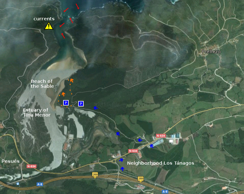
![]() La Playa del Sable está situada en la localidad de Prellezo, perteneciente al municipio de Val de san Vicente. Esta playa se ubica en la costa occidental de Cantabria, dentro de la Ría de Tina Menor. Apta para el baño y el disfrute de la naturaleza. Al norte de la playa, a 600 metros aproximadamente, confluyen el Mar y la entrada a la Ría. Allí las corrientes son más fuertes. Cuenta con dos accesos directos a la playa y pequeñas zonas utilizas a modo de aparcamiento, a 300 metros del arenal.
La Playa del Sable está situada en la localidad de Prellezo, perteneciente al municipio de Val de san Vicente. Esta playa se ubica en la costa occidental de Cantabria, dentro de la Ría de Tina Menor. Apta para el baño y el disfrute de la naturaleza. Al norte de la playa, a 600 metros aproximadamente, confluyen el Mar y la entrada a la Ría. Allí las corrientes son más fuertes. Cuenta con dos accesos directos a la playa y pequeñas zonas utilizas a modo de aparcamiento, a 300 metros del arenal.
Beach of the Sable, access
![]() The Beach of the Sable is placed in the locality of Prellezo, belonging to the municipality of Val de San Vicente. This beach is located on the western coast of Cantabria, inside the Estuary of Tina Menor. Suitable for the swiming and the enjoyment of the nature. To the north of the beach, to 600 meters approximately, the Sea and the entry of the Estuary meet together. There, the currents are stronger. It possesses two direct accesses to the beach and small zones that you can use like parking, to 300 meters of the sandbank.
The Beach of the Sable is placed in the locality of Prellezo, belonging to the municipality of Val de San Vicente. This beach is located on the western coast of Cantabria, inside the Estuary of Tina Menor. Suitable for the swiming and the enjoyment of the nature. To the north of the beach, to 600 meters approximately, the Sea and the entry of the Estuary meet together. There, the currents are stronger. It possesses two direct accesses to the beach and small zones that you can use like parking, to 300 meters of the sandbank.
Acceso/Access
Playa del Sable, localización
![]() La Playa del Sable se encuentra en la localidad de Prellezo, perteneciente al municipio de Val de San Vicente; en la costa occidental de Cantabria. Debido a que esta zona no aparece en las guías oficiales, La ruta finaliza a unos metros de la carretera que conduce a la playa. Después de atravesar la rotonda, la segunda salida a la izquierda de la carretera, nos lleva hasta el arenal. Se muestran a continuación como puntos de partida: Oviedo, Palencia, Santander y Bilbao. Comenzando el viaje por autovía y finalizando el recorrido por la misma carretera nacional en todos los trayectos.
La Playa del Sable se encuentra en la localidad de Prellezo, perteneciente al municipio de Val de San Vicente; en la costa occidental de Cantabria. Debido a que esta zona no aparece en las guías oficiales, La ruta finaliza a unos metros de la carretera que conduce a la playa. Después de atravesar la rotonda, la segunda salida a la izquierda de la carretera, nos lleva hasta el arenal. Se muestran a continuación como puntos de partida: Oviedo, Palencia, Santander y Bilbao. Comenzando el viaje por autovía y finalizando el recorrido por la misma carretera nacional en todos los trayectos.
Beach of the Sable, localization
![]() The Beach of the Sable is in the locality of Prellezo, belonging to the municipality of Val de San Vicente; on the western coast of Cantabria. Due to this zone does not appear in the official guides, the route finishes to a few meters of the road that leads to the beach. After crossing the roundabout, the second exit to the left of the road, will takes us up to the sandbank. Shown below as starting points: Oviedo , Palencia , Santander and Bilbao . Beginning the trip for motorway and finishing the tour for the same national road in all the options.
The Beach of the Sable is in the locality of Prellezo, belonging to the municipality of Val de San Vicente; on the western coast of Cantabria. Due to this zone does not appear in the official guides, the route finishes to a few meters of the road that leads to the beach. After crossing the roundabout, the second exit to the left of the road, will takes us up to the sandbank. Shown below as starting points: Oviedo , Palencia , Santander and Bilbao . Beginning the trip for motorway and finishing the tour for the same national road in all the options.
Localización/Localization


El Muro, acceso
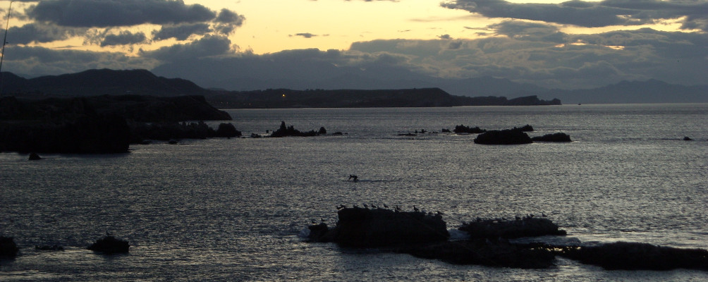
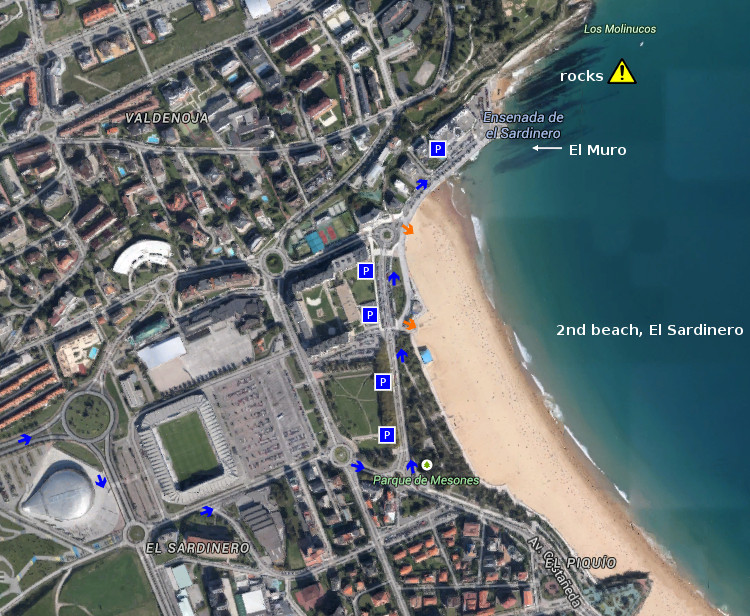
![]() El Muro está situado en el extremo norte de la segunda playa de El Sardinero, ubicada en Santander. Esta parte central de la costa cántabra esta protegida por la ensenada que forma Cabo Menor con la Península de la Magdalena. Cuenta con dos accesos directos al arenal y varias zonas de aparcamiento.
El Muro está situado en el extremo norte de la segunda playa de El Sardinero, ubicada en Santander. Esta parte central de la costa cántabra esta protegida por la ensenada que forma Cabo Menor con la Península de la Magdalena. Cuenta con dos accesos directos al arenal y varias zonas de aparcamiento.
El Muro Beach, access
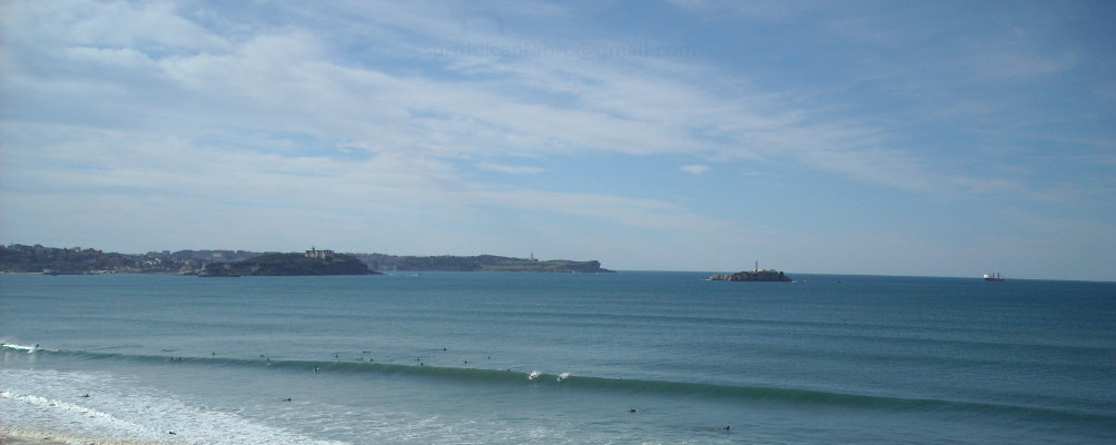
![]() El Muro is placed in the north end of the second beach of The Sardinero, located in Santander. This central part of the Cantabrian coast is protected by the inlet that forms Cape Menor with the Peninsula of La Magdalena. It possesses two direct accesses to the sandbank and several zones of parking.
El Muro is placed in the north end of the second beach of The Sardinero, located in Santander. This central part of the Cantabrian coast is protected by the inlet that forms Cape Menor with the Peninsula of La Magdalena. It possesses two direct accesses to the sandbank and several zones of parking.
Acceso/Access
El Muro, localización
![]() El Muro está situado en el extremo norte de la segunda playa de El Sardinero, en Santander. Es la parte final de una playa urbana que cuenta con todos los servicios. Se muestran a continuación como puntos de partida: Oviedo, Palencia, Santander y Bilbao. Comenzando el viaje por autovía y finalizando el recorrido por la misma carretera nacional en todos los trayectos.
El Muro está situado en el extremo norte de la segunda playa de El Sardinero, en Santander. Es la parte final de una playa urbana que cuenta con todos los servicios. Se muestran a continuación como puntos de partida: Oviedo, Palencia, Santander y Bilbao. Comenzando el viaje por autovía y finalizando el recorrido por la misma carretera nacional en todos los trayectos.
El Muro, localization
![]() El Muro is placed in the north end of the second beach of El Sardinero, in Santander. It is the final part of an urban beach that has all the services. Shown below as starting points: Oviedo , Palencia , Santander and Bilbao . Beginning the trip for motorway and finishing the tour for the same national road in all the options.
El Muro is placed in the north end of the second beach of El Sardinero, in Santander. It is the final part of an urban beach that has all the services. Shown below as starting points: Oviedo , Palencia , Santander and Bilbao . Beginning the trip for motorway and finishing the tour for the same national road in all the options.
Localización/Localization