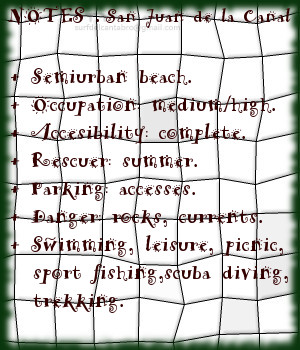
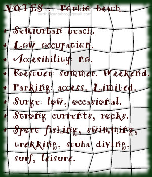
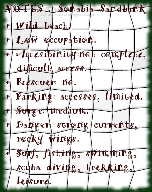
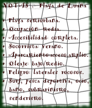
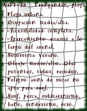
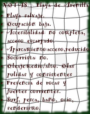
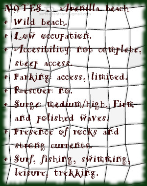
San Juan de la Canal, playa
![]() La playa de San Juan de la Canal se ubica en la localidad de Soto de la Marina, dentro del municipio de Santa Cruz de Bezana. Situada a menos de 10 km de Santander, en la costa central de Cantabria; goza de la proximidad a la capital cántabra conservando recogimiento y parte de su condición natural. Las reducidas dimensiones de la playa, 600 metros de longitud y 50 metros de ancho medio, disponen un arenal llano, de fina y endurecida arena.
La playa de San Juan de la Canal se ubica en la localidad de Soto de la Marina, dentro del municipio de Santa Cruz de Bezana. Situada a menos de 10 km de Santander, en la costa central de Cantabria; goza de la proximidad a la capital cántabra conservando recogimiento y parte de su condición natural. Las reducidas dimensiones de la playa, 600 metros de longitud y 50 metros de ancho medio, disponen un arenal llano, de fina y endurecida arena.
La Punta de San Juan de la Canal, cabo situado en dirección este, contiene a la playa en el principio de su cara interior. El Pico del Sol, alejado del arenal y situado en la prolongación de su lado derecho, delimita la zona de influencia de la playa. El contorno que rodea la playa, dispone de varias carreteras, caminos y senderos que facilitan la entrada desde prácticamente cualquier punto.
El fondo rocoso, con abundante pradera marina, crea un hábitat rico y diverso. Las aguas de color verde azuladas reflejan la naturaleza del Mar Cantábrico, que pule las rocas y fondo marino convirtiendo a esta zona en un lugar de alto valor para la practica del submarinismo, el baño y paddle surf.

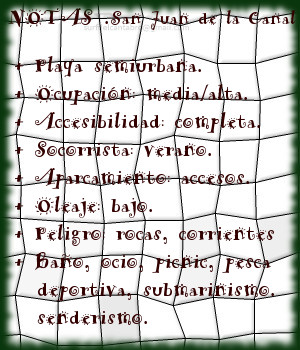
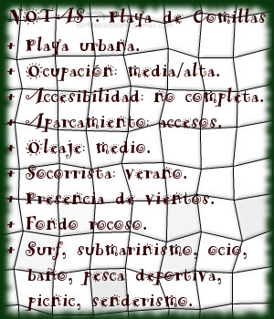
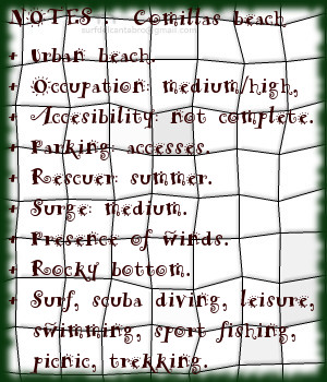
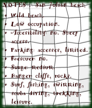
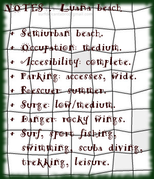
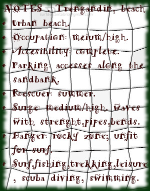
San Juan de la Canal, beach
![]() The beach of San Juan de la Canal is located in the locality of Soto de la Marina, belonging to the municipality of Santa Cruz de Bezana. Placed less than 10 km from Santander, on Cantabria’s central coast; it enjoys the proximity to the Cantabrian capital, preserving its privacy and part of its natural condition. The limited dimensions of the beach, 600 meters of length and 50 meters of average width, creates a flat sandbank, of thin and hard sand.
The beach of San Juan de la Canal is located in the locality of Soto de la Marina, belonging to the municipality of Santa Cruz de Bezana. Placed less than 10 km from Santander, on Cantabria’s central coast; it enjoys the proximity to the Cantabrian capital, preserving its privacy and part of its natural condition. The limited dimensions of the beach, 600 meters of length and 50 meters of average width, creates a flat sandbank, of thin and hard sand.
The Tip of San Juan de la Canal, end placed in East direction, contains to the beach in the beginning of its interior face. The Beak of the Sol, removed from the sandbank and placed in the prolongation of its right side, delimits the zone of influence of the beach. The contour that surrounds the beach, has several roads, ways and paths that facilitate the entry from practically any point.
The rocky bottom, with abundant marine meadow, creates a rich and diverse habitat. The bluish waters of green color reflect the nature of the Cantabrian Sea, which smooths the rocks and sea bed converting to this zone into a place of high value for the practice of the scuba diving, the swimming and paddle-surf.