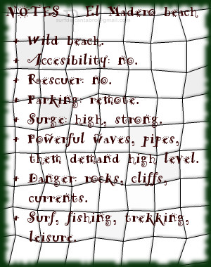
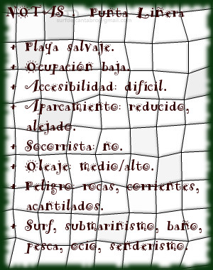
Carretera de la costa. VI

Icono Español. Icon Spanish A lo largo de los años los temporales habían re-dibujado la playa de Langre. Desplazando arena a las zonas contiguas y trayendo las de nuevo en temporales posteriores. Varía su fondo, siendo así dinámico, pero conservando la esencia que une el Mar con Langre y generando nuevas olas con multitud de formas.

A las 7 de la mañana estábamos en la playa. Un viento fresco cruzaba el arenal, transmitiendo una sensación de alegría que contrastaba con el frío que se posaba sobre la cara. La pleamar estaba prevista para las 9 A.M horas y las olas, ya con buen tamaño, iban creciendo camino de los dos metros. Cada uno de nosotros se vestía el traje a su manera y calentaba los músculos como podía. Sobre la cima del acantilado sonó el ruido de una furgoneta entrando en el aparcamiento. Más gente iba llegando. A nuestra espalda, la pared del acantilado daba protección y privacidad, alejando el viento que mecía con tino los campos de maíz.
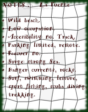
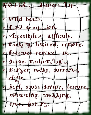
Coast Highway. VI

Icono Inglés. Icon English Throughout the years the temporary ones had re-drawn Langre’s beach. Displacing sand to the contiguous zones and bringing again with the temporaries that happened later. It changes its bottom, being like that dynamic, but preserving the essence that joins the Sea with Langre and generating new waves with multiple forms.

At 7 a.m. we were in the beach. A fresh wind was crossing the sandbank, transmitting a sensation of happiness that was contrasting with the cold that was settling on the face. The tide was foreseen for 9 A.M hours and the waves, already with good size, were growing way up to two meters. Each of us was dressing the suit on his own and was warming the muscles as we could. On the top of the cliff the noise of a van sounded when was entering in the parking. More people were coming. To our back, the wall of the cliff was giving protection and privacy, removing the wind that was rocking with tact the fileds of maize.

Icon close Sponsor

Share

Carretera de la costa. V

Icono Español. Icon Spanish Sentado, mirando el mar, veía a los otros. A lo lejos una mano se agitaba. Irne señalaba hacia la posición de Dani que se encontraba a 30 metros de él. Una buena ola llegaba. Juntaron sus posiciones, separados por unos metros. Dani se subió primero, el otro le siguió. Sobre la cresta resbalaba la tabla. Continuando el viaje en la cima, corrió una buena distancia. Irne surfeaba paralelo a la ola, desde la base. Antes de su cierre, salió del tubo, para terminar tumbado sobre la tabla hasta llegar a la orilla. Dani subió y bajó por la pared de agua varias veces. Los brazos extendidos y los pies incrustados a la cera de la tabla, transmitían una sensación de armonía y libertad. Irne llegó hasta mí, para terminar el día viendo como Dani finalizaba emocionado su viaje.

Coast Highway. V

Icono Inglés. Icon English Seated, looking to the sea, I saw others. In the distance a hand was moving. Irne was indicating towards Dani’s position that was to 30 meters from him. A good wave was coming. They joined their positions, separated by a few meters. Dani raised himself first, the other one continued. On the comb it was slipping the board. Continuing the trip in the top, he traversed a good distance. Irne was surfing parallel to the wave, in the base. Before its closing, he went out of the pipe, to end knocked down on the shape up to coming to the shore. Dani raised and lowered in the water wall several times. The widespread arms and the feet incrusted to the wax of the table, were transmitting a sensation of harmony and freedom. Irne came up to me, to end the day seeing as Dani was finishing thrilled his trip.

Icon close Sponsor

Share

Carretera de la costa. IV

Icono Español. Icon Spanish El Mar descanso la siguiente media hora. Alguna ola fue aprovechada. El avance de la mañana había acercado más surfers al agua. Las conversaciones, esparcidas por todo el área, sucedían a las maniobras realizadas por otros compañeros.

Pasado el mediodía, con la pleamar atrás, el agua se terminó de llenar con más gente. Pocos espacios había libres para las últimas olas que habrían de llegar. Una onda mediana llevó a varios colegas, dejando un espacio libre. Otra ola arribó inmediatamente. Remé desplazando la tabla hacia la izquierda. A medio camino, alcanzó mi deslizante. Bajando hasta la base aguante el empujón. Equilibrando el peso sobre la tabla, avance unos metros hacia delante, para girar y chocar contra el rizo que iba formando. De nuevo en la base, busqué su camino que se fue difuminando a medida que la ola reducía su tamaño. Aproveche el impulso para llegar a la arena.

Coast Highway. IV

Icono Inglés. Icon English The Sea rested the following half hour. Some waves were taken advantage of. The proceed of the morning had brought more surfers over to the water. The conversations, spread all over the area, were mixed to the maneuvers realized by other companions.

Spent the midday, with the high-tide behind, the water ended filling with more people. Few spaces there were the free, for the last waves that should come. A medium wave took several colleagues, leaving a free area. Another wave arrived immediately. I rowed, displacing the shape towards the left side. In half-way, it reached my board. Going down up to the base, I stood its push. Balancing the weight on the table, I advance a few meters towards ahead, to turn and to hit against the curl that it was forming. Again in the base, I looked for its way that was fading away as the wave was reducing its size. I took advantage of the impulse to come to the sand.

Icon close Sponsor

Share

Carretera de la costa. III

Icono Español. Icon Spanish En el muro las olas rompen a izquierdas. Cada ola que llega al circuito tropieza de frente con el muro. Saluda el mar a la pared de rocas. La voltea y rodea, esculpiendo formas con su volumen de agua. Transformando la energía en un incremento del nivel del mar. Sigue corriendo y llegando más agua. La acumulación alcanza un límite, a partir del cual se inicia el viaje, que siempre es diferente. Suena la ola conforme avanza y nunca suena igual; aquí y en la otra parte del mundo. Suena, suena, las olas, el surf y el mar.

Transcurría la mañana con vitalidad. La media hora siguiente, Dani recuperó el tiempo perdido. Después de dos olas rápidas, con viajes de corto alcance, irrumpió sobre la cima de una nueva ola. Con sus rodillas flexionadas, giró y descendió por el tobogán que se formó. Moviendo su tabla a la misma velocidad que llevaba la onda, alcanzó el ritmo de aquella. Subiendo y bajando, cortaba con giros la pared de líquido. Nosotros, desde atrás, veíamos abanicos de agua dispersa que desaparecían en un instante. Su figura registraba la potencia del trayecto. Equilibrado avanzó larga distancia hasta frenar la tabla con el agua, para alzar los brazos y terminar zambullendose.

Coast Highway. III

Icono Inglés. Icon English In El Muro the waves break to the left side. Every wave that comes to the begining of the circuit, stumbles opposite the wall. Greets, the sea, to the rock wall. It turns and surrounds it, drawing forms with its volume of water. Transforming the energy into an increase of the level of the sea. It continues running and coming more water. The accumulation reaches a limit, from which there begins the trip, which always is different. The wave sounds as it advances and it never sounds equally; here and in another part of the world. It sounds, sounds, the waves, the surf and the Sea.

Elapsing the morning with vitality. The half following hour, Dani recovered the lost time. After two rapid waves, with trips of short scope, he burst on the top of a new wave. With his knees flexionae, he turned and descended for the slide that was formed. Moving his table to the same speed that was taking the wave, he reached the pace of that one. Rising and going down, he was cutting with drafts the liquid wall. We, from behind, saw ranges of dispersed water that were disappearing in an instant. His figure was registering the power of the journey. Balanced, he advanced long distance up to stopping the table with the water, to lift the arms and to end submerging.

Icon close Sponsor

Share

Sopico, lugar

Icono Español. Icon Spanish. Sopico, lugar Sopico, emplazamiento localizado en la localidad de Suances, es un pequeño cabo que separa las playas de Los Locos y La Tablía. La marea baja descubre las rocas que se apilan en la base del acantilado, quedando la arena cubierta por el agua.

Al acceso a este punto de olas se realiza por las playas colindantes. Destacan las fuertes corrientes y el oleaje, proporcionando olas prácticamente durante todo el año. La ola característica de Sopico abre a izquierdas, manteniendo la misma calidad sin importar las mareas. Aparecen olas cortas y maniobrables, alternadas con olas más profundas y de recorrido medio/largo. Debido a sus características tiene una ocupación alta, siendo exigido respetar las normas y turnos.

La cima de Sopico cuenta con un mirador panorámico que abre al caminante la amplitud de la Ensenada de Cabrera. La La contemplación del entorno recorre desde Suances a la derecha hasta Punta Ballota cerrando extremo izquierdo, entreteniendo la mirada sobre el horizonte; que mostrará la naturaleza del Mar Cantábrico.

Cabecera Cities Place Beaches . Sopico, lugar
Sopico, notas

Sopico, place

Icono Inglés. Icon English. Sopico, lugar Sopico, emplacement located in the locality of Suances, is a small end that separates the beaches of Los Locos and La Tablía. The low tide discovers the rocks that are piled up in the base of the cliff, staying the sand covered by the water.

The access to that point of waves it is realized by the adjacent beaches. The strong currents and the surge stand out, providing waves practically all the year round. The wave typical Sopico’s opens to left sides, supporting the same quality without importing the tides. There appear short and manoeuvrable waves alternated with deeper waves and of meium tour. Due to its characteristics it has a high occupation, being demanded the respect to the procedure and shifts.

The top of Sopico has a panoramic viewing-point that opens the wayfarer the extent of Cabrera’s Inlet. The contemplation of the environment crosses from Suances to the right up to Ballota Tip closing the left wing, entertaining the look on the horizon; that will show the nature of the Cantabrian Sea.

Cabecera Cities Place Beaches. Sopico, place
Sopico, notes

Share

El Muro, lugar

Icono Español. Icon Spanish. El Muro, lugar El Muro es una zona que abre un singular circuito para la práctica del surf. Situado en ampliación de la dársena urbana que delimita la ciudad de Santander con la Segunda playa del Sardinero, tiene fácil acceso y cuenta con todos los servicios.

La prolongación de este espacio natural ha introducido su diseño dentro de la Ensenada del Sardinero. Un gran mirador semicircular señala lo puntos más notables de la bahía y actúa como acumulador del oleaje. Llegan las olas hasta este punto para aglutinar masas de agua que abren a izquierdas y pueden alcanzar recorrido medio. Cuando la dirección del oleaje es casi perpendicular a la dársena y ligeramente orientado hacia ella; se dan las mejores condiciones para olas buenas y seguras. El exceso de inclinación provocan que las olas cierren contra el muro; tornando la navegación difícil y peligrosa.

Múltiples opciones aparecerán contemplando el entorno desde EL Muro. Las playas vistas en la distancia, las rocas y promontorios recorridos por un paseo marítimo invitan al caminante a iniciar un pequeño viaje acompañado por el natural, caótico y armónico sonido del mar.

Cabecera Cities Place Beaches . El Muro, lugar
El Muro, notas

El Muro, place

Icono Inglés. Icon English. El Muro, place El Muro is a zone that opens a singular circuit for the practice of surf. Placed in extension of the urban dock that delimits the city of Santander with the Second Sardinero beach , it has easy access and possesses all the services.

The prolongation of this natural space has introduced its design in the Inlet of the Sardinero. A great semicircular viewing-point indicates the most notable points of the bay and acts as accumulator of the surge. The waves come up to this point to agglutinate water masses that open to left sides and can reach medium tour. When the wave direction is almost perpendicular to the dock and lightly orientated towards it; are given the best conditions for good and sure waves. The excess of inclination provoke that the waves close against the wall; turning the navigation difficult and dangerous.

Multiple options will appear contemplating the environment from El Muro. The beaches are seen in the distance, the rocks and promontories crossed by a promenade invite the wayfarer to initiate an small trip accompanied by the natural, chaotic and harmonic sound of the Sea.

Cabecera Cities Place Beaches. Pedreña, beach
El Muro, notes

Share

El Madero, playa

Icono Español. Icon Spanish. El Madero, playa la playa El Madero se ubica en la localidad de Liencres, perteneciente al municipio de Piélagos, en la costa central de Cantabria. Su complicado acceso e irregular arenal la convierten en una playa tranquila donde poder disfrutar del Mar Cantábrico en estado puro.

Emplazada en el extremo de la playa de Canallave, sólo es accesible en marea baja. La configuración de la costa, la presencia de rocas y formaciones geológicas constituyen un atractivo para el caminante. Estos tesoros quedan parcialmente cubiertos con la marea alta que impide la entrada y sesga El Madero, camuflando su espacio con las aguas y el oleaje. La presencia de olas, como ocurre en toda la zona, es constante y habitual. Tiene varios picos y olas características. Abren a ambos lados, de medio recorrido y con presencia de tubos. Situando a 200 metros de la orilla, la zona de confort dispone mejor trazado y aleja el peligro de las rocas que habitan en todo el área. La práctica del surf en EL Madero es sólo aconsejable para surfers experimentados que conozcan bien esta singular cala. Además de las rocas, las corrientes tienen una dinámica irregular y cambiante que es reflejado en las olas.

La cima del acantilado que cierra El Madero disfruta del sonido del mar percibido en la distancia y proporciona una visión del entorno que se endulza con el atardecer.

Cabecera Cities Place Beaches . El Madero, playa
ElMadero, notas

El Madero, beach

Icono Inglés. Icon English. El Madero, beach The beach El Madero is located in the ocality of Liencres, belonging to the municipality of Piélagos, on the central coast of Cantabria. Its complicated access and irregular sandbank turn it into a calm beach where to be able to enjoy the Cantabrian Sea in pure condition. The presence of waves, as happens in the whole zone, is constant and habitual. It has several beaks and typical waves. Them open to both sides, have medium distance with presence of pipes. Placing to 200 meters of the shore, the zone of comfort arranges better tracing and removes the danger of the rocks that live in all the area.

Located in the end of Canallave’s beach, only it is accessible in low tide. The configuration of the coast, the presence of rocks and geological formations constitute an attractive for the wayfarer. These exchequers remain partially covered with the high tide that prevents the entry and cuts El Madero, camouflaging its space with the waters and the surge. The practice of surf in El Madero is only advisable for experienced surfers that know well this singular cove. Besides the rocks, the currents have an irregular and changeable dynamics that is reflected in the waves.

The top of the cliff that closes El Madero enjoys the sound of the sea perceived in the distance and provides a vision of the environment that is sweetened by the late afternoon.

Cabecera Cities Place Beaches. Barnejo, beach
ElMadero, notes

Share

La Fuente, playa

Icono Español. Icon Spanish. La Fuente, playa La playa La Fuente, ubicada en San Vicente de las Barquera; en la costa occidental de Cantabria, es una pequeña cala de 150 metros de longitud y 20 metros de anchura media. Conservada prácticamente en estado natural, presenta baja ocupación y no dispone de ningún servicio.

La Punta de África, a la izquierda, y la Punta del Fraile, a la derecha, contienen la ensenada y delimitan el arenal. Sus reducidas dimensiones y orografia descubren un entorno singular. Abierta al mar, recibe la fuerza del Cantánbrico que baña la costa y es modulado por los acantilados de la zona. El fuerte oleaje que llega a La Fuente abre a ambos lados. El corto recorrido que alcanzan las ondas favorece las maniobras. La profundidad de la Ensenada de Fuentes proporciona varios picos de olas, a diferentes distancias de la orilla. A medida que avanzamos hacia mar abierto las corrientes, ya presentes, aumentan su fuerza. Por este motivo, adentrarse a los picos alejados es sólo recomendable para surfers experimentados y conscientes de los riesgos.

La apartada localización, las dimensiones, rocas y corrientes son características que definen a esta cala y proyectan virtudes que ayudan a desconectar mientras se surfea y disfruta de su diferente navegación.

Cabecera Cities Place Beaches . La Fuente, playa
La Fuente, notas

La Fuente, beach

Icono Inglés. Icon English. La Fuente, beach The beach of La Fuente, located in San Vicente de la Barquera; on the western coast of Cantabria, it is a small cove with 150 meters of length and 20 meters of average width. Preserved practically in natural condition, it presents low occupation and has not any service.

The Tip of Africa, to the left side, and the Tip of El Fraile, to the right, contain the inlet and delimit the sandbank. Its limited dimensions and orography discover a singular environment. Opened the sea, it receives the force of the Cantánbrico that washes the coast and is modulated by the cliffs of the zone. The strong surge that comes to La Fuente opens to both sides. The short tour that the waves reach favors the maneuvers. The depth of the Inlet of Fuentes provides several beaks of waves, to different distances of the shore. As we advance towards open sea the currents, already present, increases its force. Due to this motive, to enter to the remote beaks, is only advisable for experienced surfers and conscious of the risks.

The isolated location, the dimensions, rocks and currents are features that define to this cove and project virtues that help to disconnect while you are surfing and enjoying its different navigation.

Cabecera Cities Place Beaches. La Fuente, beach
La Fuente, notes

Share

Punta Liñera, playa

Icono Español. Icon Spanish. Punta Liñera, playa Punta Liñera es un pequeña cala emplazada en San Vicente de la Barquera, en la costa oriental de Cantabria. Sus reducidas dimensiones, apenas 150 metros en un parte más ancha; con la arena sólo visible en marea baja, sirven de acceso a un entorno que ofrece múltiples posibilidades.

Punta Liñera, nombre que recibe el cabo que protege y bautiza la cala, forma una ensenada que es acotada en su extremo derecho por la Punta del Castillo. La rasa mareal que cimenta sus fondos contribuye a crear un rico ecosistema y contribuye a la biodiversidad de sus aguas. Fondos de roca pulida y erosionada por efecto del Mar Cantábrico a lo largo del tiempo habitan cerca de la costa. Más allá, el Mar arriba libre recorriendo la costa y formando una ola característica de izquierdas, rápida y tubera.

EL paseo por los acantilados descubre la amplitud del entorno y su riqueza paisajística. Hacia el Oeste la costa de Pechón, al Este la costa de San Vicente de la Barquera. Refulgente visión que fusionará el espacio con la imaginación

Cabecera Cities Place Beaches . Punta Liñera, playa
Punta Liñera, notas

Liñera Tip, beach

Icono Inglés. Icon English. Liñera Tip, beach Liñera Tip is an small cove located in San Vicente de la Barquera, on the oriental coast of Cantabria. Its limited dimensions, no more than 150 meters in its width; with the sand only visible in low tide, is used as access to an environment that offers multiple possibilities.

Liñera Tip, name that receives the end that protects and baptizes the cove, forms an inlet that is annotated in its right wing by El Castillo Tip. The tidal plain that establishes its funds helps to create a rich ecosystem and the biodiversity of its waters. Funds of polished and eroded rock by effect of the Cantabrian Sea throughout the time are near the coast. Beyond, the Sea arrives freely crossing the coastline and forming a characteristic wave that open to left sides, with speed and pipes.

The promenade along the cliffs discovers the extent of the environment and its landscape wealth. Towards the West Pechón’s coast, in the eastern part San Vicente de la Barquera coast. Refulgent vision that would fuse the space with the imagination

Cabecera Cities Place Beaches. Liñera Tip, beach
PuntaLiñera, notes

Share

La Virgen del Mar, playa

Icono Español. Icon Spanish. La Virgen del Mar, playa La playa de la Virgen del Mar se ubica en la ciudad de Santander, en la costa central de Cantabria. En la península que contiene la Ermita que da nombre a la playa, el Mar Cantábrico baña su perímetro en marea alta. Un puente que habilita el acceso a la península desde la costa, configurando su dibujo, habilitando una zona con un pequeño arenal en su cara este.

Las reducidas dimensiones de la playa, 180 metros de longitud y 50 metros de anchura media, junto con la presencia de rocas y fuertes corrientes condicionan la practica de deportes acuáticos. Destaca la pesca deportiva y el submarinismo. La práctica del surf debido a las condiciones no es apta. Las olas sesgadas, de corto recorrido y baja calidad convierte el baño en una grata experiencia, respetando las indicaciones y cuando el mar lo permita.

El entorno formado por la Ermita, la playa, los arenales y la peninsula constituyen un lugar de descanso y contemplación a través de los pasos que crucen los múltiples senderos que el tiempo marcó sobre la tierra y el viento recorre cuando la brisa marina llega a su encuentro.

Cabecera Cities Place Beaches . La Virgen del Mar, playa
La Virgen del Mar, Notas

La Virgen del Mar, beach

Icono Inglés. Icon English. La Virgen del Mar, beach The beach of La Virgen del Mar is located in the city of Santander, on the central coast of Cantabria. In the peninsula that contains the Hermitage that gives name to the beach, the Cantabrian Sea soaks its perimeter in high tide. A bridge that enables the access to the peninsula from the coast, forming its drawing, contributes to create a zone with a small sandbank in its East face.

The limited dimensions of the beach, 180 meters of length and 50 meters of average width, adding the presence of rocks and strong currents determine the practice of aquatic sports. The sports fishing and the scuba diving stands out. The practice of surf due to the conditions is not suitable. The broken waves, with short tour and low quality turns the swimming into a pleasing experience, respecting the indications and sea conditions.

The environment formed by the Hermitage, the beach, the sandbanks and the peninsula constitute a place of rest and contemplation across the steps that cross the multiple paths that the time marked on the land and the wind crosses when the breeze marine comes to its meeting.

Cabecera Cities Place Beaches. La Virgen del Mar, playa
La Virgen del Mar , Notes

Share