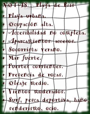
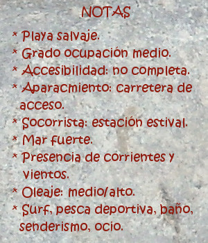
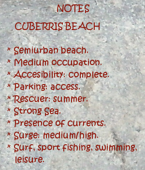
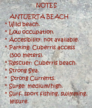
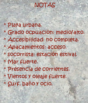
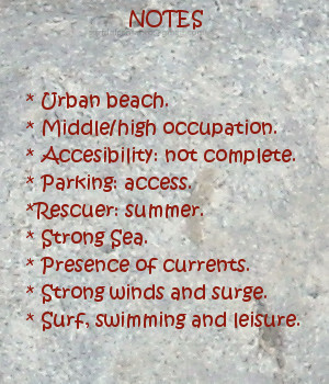
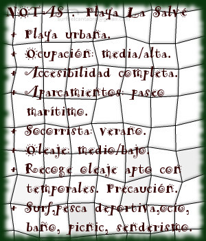
La Salvé, playa

Icono Español. Icon Spanish. La Salve, playa La playa de La Salvé se encuentra en el municipio de Laredo, ubicado en la costa oriental de Cantabria. Es un extenso arenal de más de cuatro kilómetros de longitud y anchura media aproximada de 140 metros. Jalonada por un paseo marítimo a lo largo de su recorrido que la presenta y permite al caminante disponer de una posición privilegiada para su contemplación.

Empezando el paseo en el extremo derecho, próximo al puerto deportivo, avanzan los pasos a través de la media luna que dibuja este allí. Caminando, podemos disfrutar de la villa a mano izquierda y del Mar a mano derecha. Varias entradas al arenal aparecen al encuentro para, una vez atraídos, acceder a la playa. Pasado el pequeño sistema dunar cercano al paseo, asoma un llanura que se extiende por debajo de sus aguas, pues La Salvé recuerda a una playa de otros mares. Para alcanzar profundidad, debemos recorrer una extensión mayor que en el resto de playas cántabras.

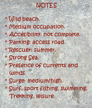
Debido a las características de la playa, la presencia de olas no es regular. Los tamaños medios ó bajos de las ondas se ven incrementados cuando arrecia temporal, abriendo numerosos picos de olas a lo largo de La Salvé, que se suceden a izquierdas y derechas. Su configuración y parámetros, la convierten en una zona ideal para practicar sky-surf y paddle-surf, wind-surf. El otoño e invierno traen a Laredo los mejores momentos de surf, que ayudados con la gran extensión y fisionomía de la zona, ofrecen a los surfistas un circuito con variedad cuantitativa y cualitativa.
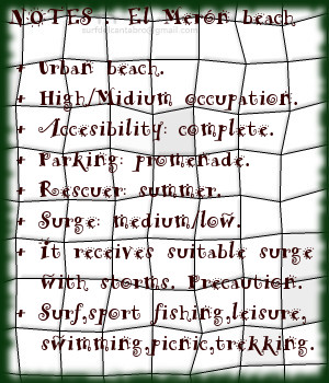
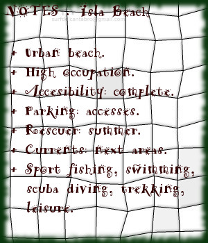
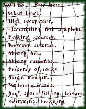
Cabecera Cities Place Beaches. La Salve, playa
La Salve, Notas

The Salvé, beach

Icono Inglés. Icon English. The Salvé, beach The beach of The Salvé is in the municipality of Laredo, located in the oriental coast of Cantabria. It is an extensive sandbank with more than four kilometres of length and average approximate width of 140 meters. Marked by a maritime walk along its tour that presents it and allows to the wayfarer to have a position favoured for the contemplation.

Beginning the walk in the right wing, next the sports port, the steps advance across the half moon that draws this one, there. Walking, we can enjoy the villa to the left hand and the Sea to the right hand. Several points to income to the sandbank appear to the meeting for; once attracted, accede to the beach. Then the small dune system near the promenade, it puts out a llanura that spreads below his waters, because The Salvé resembles a beach of other seas. To reach depth, we must cross a major extension than the rest of Cantabrian beaches.

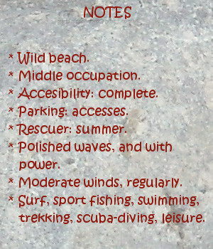
Due to the characteristics of the beach, the presence of waves is not regular. The average sizes or low of the waves are increased when storms arrive, opening numerous beaks of waves along The Salvé, that open to the left and right sides. Its configuration and parameters, turn it into an ideal zone to practise sky-surf, paddle-surf and windsurfing. The autumn and winter bring to Laredo the best moments of surf, which helped with the great extension and physiognomy of the zone, offer a circuit to the surfers with quantitative and qualitative variety.

Cabecera Cities Place Beaches. The Salve, beach
La Salve, Notes

Share

El Merón, playa

Icono Español. Icon Spanish. El Meron playa La playa El Merón está situada en San Vicente de la Barquera, municipio emplazado en la costa occidental de Cantabria. Su longitud de 2,5 kilómetros y anchura media aproximada de 60 metros, la convierten en una de las playas más extensas de Cantabria. La marea baja descubre una llanura de arena fina y compacta, sobre la que se forman y desarrollan distintos tipos de olas que el Mar Cantábrico transporta y entrega.

Delimitada en su extremo izquierdo por el espigón que separa la Ría de San Vicente de la Barquera del arenal, aparece un extenso área acotada y protegida parcialmente de la fuerza del Mar. Dibuja la costa en este punto una ligera curva que propicia variedad de olas, en cuanto a forma y extensión. Abriendo las ondas a ambos lados, destacan sus izquierdas. Alargadas y con su pared de agua sostenida, van trasladando la parte navegable de la ola hasta el final del trayecto curvado.

Continua la playa en línea recta hasta su otro extremo, al encuentro con la playa de Gerra. Es esta una zona de gran amplitud, con abundantes picos de olas que abren a ambos lados. Disponen sus ondas de varios niveles de profundidad, a diferentes distancias de la orilla. No siendo esta regla regular, cuando se cumple ofrece un variado repertorio de opciones para todos los niveles e intensidades. Destaca la naturaleza del Mar en esta parte de la costa Cántabra. La llegada de las series de olas sobre volúmenes de agua que proporcionan una suave pendiente libre y limpia para la navegación. Acuden ellas al encuentro con la fina arena sin demora, ni prisa, trasluciendo a través de su velocidad óptima una parte de su alma.

La potencia progresiva y rítmica de las aguas del Merón, produce un discurso familiar por conocido, que el recuerdo; una vez de vuelta, distinguirá como singular y único.

Cabecera Cities Place Beaches. El Meron playa
El Meron playa. Notas

The Merón, beach

Icono Inglés. Icon English. El Merón, beach The beach The Merón is placed in San Vicente de la Barquera, municipality located in the western coast of Cantabria. Its length of 2,5 kilometres and average approximate width of 60 meters, turn it into one of the most extensive beaches of Cantabria. The low tide discovers a plain of thin and compact sand, over it are formed and develop different types of waves, that are transported and delivered by the Cantabrian Sea.

Delimited in its left wing by the breakwater that separates the Stuary of San Vicente de la Barquera of the sandbank, appears an extensively and protected area which is partially shield against the force of the Sea. The coast draws, in this point, a light curve that propitiates variety of waves, in its form and extension. The waves open for both sides, stand out its left sides. Lengthened and with its supported wall of water, them move its navigable part to the end of the curved route.

It continues the beach on straight line up to its other end, to the meeting with Gerra’s beach. It is this zone of great extent, with abundant beaks of waves that open to both sides. It arrange its waves in several levels of depth, to different distances of the shore. Not being this regular rule, when it is fulfilled; it offers a varied digest of options for all the levels and intensities. The nature of the Sea stands out in this part of the Cantabrian coast. The arrival of the series of waves in water volumes which provide a soft, free and clean slope for the navigation. Them come to the encounter with the thin sand, without delay, or hurry, revealing across its ideal speed; a part of its soul.

The progressive and rhythmic power of the Merón’s waters, produces a familiar speech as known before, that the recollection; once of return, will distinguish like singular and unique.

Cabecera Cities Place Beaches. El Merón beach
El Merón beach . Notes

Share

La Tablía, playa

Icono Español. Icon Spanish. La Tablía, playa La playa La Tablía, también llamada El Huerto, se encuentra en el municipio de Suances, en el extremo oeste de la costa central de Cantabria. Esta pequeña playa, de 80 metros de longitud y una anchura media de apenas 10 metros, es cubierta prácticamente en su totalidad con la marea alta. Separada de la Playa de Los Locos por la Punta de Sopico, disfruta de la misma calidad de olas que su playa hermana mayor y más conocida, con algunas variaciones y características propias.

Descansando en la base de los acantilados que delimitan la costa de Suances, este punto con forma curvada, pendiente practicable y cubierta de vegetación, dispone de un sendero que da acceso a la cala. Tras el descenso, las abundantes rocas del pequeño arenal hacen indicar que el punto adecuado para practicar surf se encuentra a 150 metros de la orilla, aproximadamente. La presencia de rocas en el área, la cercanía del acantilado y la fuerza del mar aconsejan extremar las precauciones. Evitar la cercanía de la costa en la parte final de la navegación es recomendable. La ola de La Tablía abre a derechas y dispone un viaje largo. Su recorrido favorece el contacto con la pared de la ola, las maniobras para continuar el trayecto. El viento, la energía del Mar Cantábrico, y la morfología del fondo marino que existen en la zona moldean la potencia y forma de las olas.

Llegar a La Tablía, desde el mirador que eternamente la divisa; ver el estado de la mar, para decidir entrar y, en ese caso, cambiar la perspectiva a través de la estancia en sus aguas, en sus olas. En cada trayecto la contemplación del ondulante movimiento de la superficie de sus aguas, que quizás; darán paso al nacimiento de una nueva ola.

Cabecera Cities Place Beaches. La tablía, playa
La Tablia, Notas

Isla, beach

Icono Inglés. Icon English. La Tablía, beach The beach of La Tablía, also called El Huerto, is in the municipality of Suances, in the extreme west of the central coast of Cantabria. This small beach, it has 80 meters of length and an average width of 10 meters, is covered practically in its entirety with the high tide. Separated from the Beach of Los Locos by Sopico Tip, it enjoys the same quality of waves than its relates major and more known beach, with some variations and own characteristics.

Resting in the base of the cliffs that delimit Suances’s coast, this point with curved form, practicable slope and covered with vegetation; has a path that leads to the cove. After the descent, the abundant rocks of the small sandbank indicate that the suitable point to practise surf is to 150 meters of the shore, approximately. The rocks presence in the area, the nearness of the cliff and the force of the sea, advise to carry to extremes the precautions. To avoid the nearness of the coast in the final part of the navigation is advisable. The wave of La Tablía opens to right and arranges a long trip. Its tour favors the contact with the wall of the wave, the maneuvers to continue the journey. The wind, the energy of the Cantabrian Sea, and the morphology of the sea bed that exist in the zone; mould the power and form of the waves.

Arrive at La Tablía, from the viewing-point that eternally has fun with it; to see the condition of the Sea, to decide to enter and, in this case, to change the perspective across the stay into its waters, into its waves. In every journey, the contemplation of the undulating movement of the surface of its waters, that probably; will give step to the birth of a new wave.

Cabecera Cities Place Beaches. La Tablía, beach
La Tablia, Notes

Share

Robayera, playa

Icono Español. Icon Spanish. Rpbayera, playa La playa de Robayera se encuentra en el municipio de Miengo, en la costa central de Cantabria. Es un pequeño arenal de 100 metros de longuitud y una anchura media aproximada de 10 metros. Emplazada en la desembocadura de la Ría de Mogro, está expuesta a las fuertes corrientes que transitan del estuario hacia mar abierto y viceversa por efecto de las mareas, la morfología de la zona y la fuerza del Mar.

Esta pequeña, abrupta y rocosa cala es disfrutada en plenitud cuando recibe la marea baja. Ubicada en la ladera Este que une la Punta del Cuerno con la desembocadura de la ría, es un punto de confluencia de las corrientes y vientos de la zona. Su oleaje alto y potente es sólo apto para surfers profesionales que sean conscientes de los riesgos e impracticable cuando hay marejada.

Es por sus condiciones una zona ideal para la pesca deportiva y el senderismo. Comenzando el recorrido en la playa de Robayera, caminando sobre los acantilados, llegaremos a la Punta del Cuerno. El sonido del mar bañando la costa, acompañará cada paso sazonando el trayecto que se endulza con la contemplación del entorno. A la derecha un extenso arenal de más de 2 kilómetros de longitud, en frente un pequeño archipiélago compuesto por cuatro islotes. Desde su punto más al norte podremos divisar Suances y su entorno.

Cabecera Cities Place Beaches. Robayera, playa
Robayera beach, Notas

Robayera, beach

Icono Inglés. Icon English. Robayera, beach The beach of Robayera is in the municipality of Miengo, on the central coast of Cantabria. It is a small sandbank of 100 meters of length and an average approximate width of 10 meters. Located in the Stuary of Mogro, it is exposed to strong currents that move from the estuary towards open sea and vice versa due to effect of the tides, the morphology of the zone and the force of the Sea.

This small, abrupt and rocky cove is enjoyed in fullness when it receives the low tide. Located in the East hillside that joins El Cuerno Tip with the rivermouth , it is a point of confluence of the currents and winds of the zone. Its high and powerful surge is only suitable for professionals surfers who are conscious of the risks and impracticable when there is heavy sea.

It is for its conditions an ideal zone for sport fishing and the hiking. Beginning the tour in Robayera’s beach, walking on the cliffs, we will come to the El cuerno Tip. The sound of the sea lighting the coast, will accompany every step; which seasons the journey that is sweetened by the contemplation of the environment. To the right: an extensive sandbank of more than 2 kilometres of length, in front of us: an small archipelago composed by four islands. From its northern point, we will be able to enjoy Suances and its surroundings.

Cabecera Cities Place Beaches. Robayera, beach
Robayera beach, Notes

Share

Isla, playa

Icono Español. Icon Spanish. Isla, beach La playa de Isla, también conocida como playa del Sable, se encuentra en la localidad de Isla, perteneciente al municipio de Arnuero. Situada en la costa oriental de Cantabria, es un playa urbana de 150 metros de longitud y anchura media de 50 metros. Su belleza y emplazamiento hacen que tenga un alto grado de ocupación.

Su entorno rocoso, acantilado y urbanizado forman una simbiosis dirigida por la belleza de la naturaleza, del entorno y del paisaje final que componen todos estos elementos. El aparcamiento abundante, precede a la entrada al pequeño y singular arenal. Desde allí podemos recorrer el ala derecha que conforma la playa y la separa de la playa de los Barcos y la Ría de Quejo. Un pequeño paseo que ofrecerá un momento de contemplación para disfrutar del paisaje y las características de la playa. Ante los ojos del caminante, aparecen la extensión y lo indómito del Mar Cantábrico en esta parte de la costa cántabra. Perfilando la costa, tintadola de azul y blanco, el trasiego del mar a su encuentro con la orilla y las rocas.

A su lado izquierdo, otro acantilado la contiene. Separando la playa del mar abierto y protegiendo un espacio donde el agua cristalina arriba en calma a modo de piscina natural. Sus extremos, su arena, la calidad de sus aguas, el viento que sobre ella vuela, dejan entrever parte de su belleza, de su propia naturaleza.

Cabecera Cities Place Beaches. Isla, beach
Playa de Isla, Notas

Isla, beach

Icono Inglés. Icon English. Isla, beach The beach of Isla, also known as The beach of the Saber, is in the locality of Isla, belonging to the municipality of Arnuero. Placed on the oriental coast of Cantabria, it is an urban beach of 150 meters of length and average width of 50 meters. Its beauty and emplacement contributes to its high degree occupation.

Its rocky, steep and urbanized environment creates a symbiosis directed by the beauty of the nature, of the environment and of the final landscape that all these elements compose. The abundant parking, precedes at the entry to the small and singular sandbank. From there we can cross the right wing that shapes the beach and separates it from the beach of the Barcos and Stuary of Quejo. A small walk that will offer a moment of contemplation to enjoy the landscape and the characteristics of the beach. In front of the eyes of the wayfarer, will appear the extension and force of the Cantabrian Sea in this part of the Cantabrian coast. It outlines the coast, painting it with blue and white, the movement of the Sea to its meeting with the shore and rocks.

To its left side, another cliff contains it. Separating the beach of the open sea and preserves a space where the crystalline water arrives in calmness as a natural swimming pool. Its ends, its sand, the quality of its waters, the wind that flies over it, allow to guess part of its beauty, of its own nature.

Cabecera Cities Place Beaches. Isla, beach
Isla beach, Notes

Share

Noja, Playa de Ris .

Icono Español. Icon Spanish. Noja, Ris beach La playa de Ris está ubicada en el municipio de Noja, perteneciente a la comarca de Trasmiera; en la costa occidental de Cantabria. Su longitud de 2200 metros y anchura media de 100 metros, junto con su emplazamiento urbano, hacen de ella una playa con un alto grado de ocupación.

Este gran arenal tiene dos partes diferenciadas. Una de ellas, próxima a la Ría de Quejo, es una zona retirada, tranquila, situada en el límite de Las Marismas de Joyel (una de las tres partes que componen el Parque Natural de las Marismas de Santoña, Victoria y Joyel) y por ello se la conoce como Playa de Joyel. Gobernada por el ritmo de las mareas, que ocultan el 60% de la superficie de la playa con la pleamar. La otra zona, emplazada frente a Noja y delimitada en sus extremos por islotes rocosos, es la parte urbana de la playa de Ris. Descubre la bajamar el fondo arenoso y parcialmente cubierto por rocas, la forma curvada de la playa y el agua retrocediendo desde la orilla hacia el Mar Cantábrico; creando pequeños remolinos en los laterales por los efectos de las corrientes.

La Playa de Ris es, por sus características, recomendable para el ocio, la pesca y el baño. Ideal para la práctica de paddle sup, con la mar tranquila. Surfear en esta playa produce sesiones entretenidas para todos los niveles cuando las condiciones son aceptables. Allí, La Mar fuerte es sólo apta para surfers experimentados que conozcan bien la zona y para caminantes que quieran disfrutar del espectáculo de un temporal en esta parte de la costa cántabra.

Cabecera Cities Place Beaches. Noja, Ris beach
Ris, Notas

Noja, Ris beach

Icono Inglés. Icon English. Noja, Ris beach The beach of Ris is located in the municipality of Noja, belonging to the region of Trasmiera; on the western coast of Cantabria. Its length of 2200 meters and average width of 100 meters, added up to its urban emplacement, do of it a beach with a high degree of occupation.

This great sandbank has two differentiated parts. One of them, next to the Stuary of Quejo , it is a calm and remote zone, placed in the limit of The Marshes Joyel (one of three parts that compose the Nature reserve of Santoña’s Marshes, Victoria and Joyel) and due to this is known as Beach of Joyel. Governed by the pace of the tides, which conceals the 60% of the surface of the beach with the high tide. The other zone located opposite to Noja and delimited in its ends by rocky islands, is the urban part of Ris’s beach. The low tide discovers the sandy bottom and partially covered by rocks, the curved form of the beach and the water moving back from the shore towards the Cantabrian Sea; creating small whirlpools in the wings because of the effects of the currents.

The Beach of Ris is advisable for the leisure, the fishing and the swimming. Ideal for the practice of paddle sup, with the calm sea. To play surf in this beach produces enjoyable sessions for all the levels when the conditions are acceptable. There, The strong Sea is only suitable for experienced surfers that know well the zone and for wayfarers who want to enjoy the spectacle of the storm in this part of the Cantabrian coast.

Cabecera Cities Place Beaches. Noja, Ris beach
Ris beach, notes

Share

Gerra, playa

Icono Español. Icon Spanish. Gerra, playa La playa Gerra, también llamada El Cabo, se encuentra en el municipio de San Vicente de la Barquera; en la costa occidental de Cantabria. Situada en la cara oeste del cabo que une la costa de San Vicente de la Barquera con la costa de Oyambre, es una playa de 900 metros de longitud y una anchura media aproximada de 30 metros.

Su escarpado acceso esconde parcialmente a Gerra y da entrada a un emplazamiento idílico con vistas panorámicas, que en los días de buena visibilidad muestran parte de la costa asturiana y Los Picos de Europa. A los pies de los acantilados y protegida por El Cabo de Oyambre, recoge los vientos de la ensenada y las corrientes de la zona. Destaca la calidad de sus aguas, limpias y trasparentes, que dejan traslucir sus fondos cerca de la orilla; sólo enturbiada por las fuertes corrientes que hay en el área y el viento, presente de manera habitual.

El emplazamiento de Gerra, entre acantilados y formaciones rocosas, hacen que su fondo arenoso se mezcle con rocas sueltas y diseminadas por todo el área. Las zonas cercanas a la orilla y próximas al pico PeñaEntera son evitables en la práctica del surf, pues además las corrientes son fuertes cerca de la pico montañoso que delimita a Gerra. Nacen las olas a 100 metros de la arena, siendo su recorrido de pequeña e «intensa» extensión. Abren sus olas a izquierdas y derechas, combandose por el trazado curvo de la playa, favoreciendo las maniobras y el viaje activo para su navegación.

Corre el aire, vuela sobre las aguas de Gerra, proporcionando energía a sus olas, moldeando sus formas. Prologando en el tiempo y en el espacio las paredes de agua que allí se forman. Si está ausente, es que ya pasó, y sobre las ondas reflejado queda su filtrado, su pulido acabado, sello característico de esta singular zona de la costa cántabra.

comic, mountain
Gerra, notas

Gerra, beach

Icono Inglés. Icon English. Gerra, beach The beach of Gerra, also called El Cabo, is in the municipality of San Vicente de la Barquera; on the western coast of Cantabria. Placed in the west side that joins the coast of San Vicente de la Barquera with Oyambre’s coast, is a beach of 900 meters of length and an average approximate width of 30 meters.

Its steep access hides partially Gerra and gives entry to an idyllic emplacement with panoramic view, that in the days of good visibility show part of the Asturian coast and the massif Picos de Europa. To the feet of the cliffs and protected by Oyambre’s Cape, which gathers the winds of the inlet and the currents of the zone. Stands out the quality of its waters, clean and clear, that show its funds near the shore; only muddied by the strong currents that exist in the area and the wind, present in an habitual way.

The emplacement of Gerra, between cliffs and rocky formations, which do that its sandy bottom mixes with free and scattered rocks in all the area. The zones near to the shore and next the beak PeñaEntera are avoidable in the practice of the surf, since in addition the currents are strong near its mountainous peak that delimits Gerra. The waves are born to 100 meters of the sand, being its tour with small and intense extension. It open its waves for left and rights sides, curving because of the curved tracing of the beach, favoring the maneuvers and the active trip for its navigation.

It traverses; the air, flies on Gerra’s waters, providing energy to its waves, molding its forms. It extend, in the time and in the space, the water walls that there are formed. If it is not in, it is that already it happened, and on the waves is reflected its filtered, its polished ended, typical stamp of this singular zone of the Cantabrian coast.

comic, mountain
Gerra, notes

Share

Oyambre, playa

Icono Español. Icon Spanish. Oyambre, playa La playa de Oyambre está situada en el municipio de Valdáliga, emplazado en la costa occidental de Cantabria. Situada dentro del Parque Natural de Oyambre, es un extenso arenal de 1800 metros de longitud dispuestos en linea recta y curvando su ala izquierda por la morfología de su entorno dominado por acantilados. El extremo derecho continúa a través de la costa cántabra hasta perderse en el horizonte.

La entrada a la playa se realiza a través de un pequeño aparcamiento habilitado para 50 vehículos, aproximadamente. La contemplación de Oyambre produce en el caminante una sensación acogedora e intima, que contrasta con la amplitud y enormidad del entorno. Salvaje y naturalmente dibujada, es recorrida por el viento en toda su plenitud que la visita de forma casi regular. Su extensión se plasma por medio de una llanura de arena endurecida, con una leve pendiente hasta la orilla, a modo de invitación para conocer sus aguas. La playa de oyambre, por sus características, sirvió en el siglo pasado de pista de aterrizaje del llamado «Pájaro amarillo»; primer avión que cruzó el Océano Atlántico en una travesía de 29 horas. Esto da una idea de la singularidad del lugar.

Baña el Mar la costa y la playa, ondula suavemente el fondo arenoso por los efectos de las mareas y el oleaje. Aparecen las ondas en diversos picos de olas que existen en la playa. Su forma pulida y recorrido alargado,en la zona central, se combina con áreas donde estas recorren menor extensión y favorecen las maniobras. Golpea el Mar Cantábrico al surfista, iniciando así la navegación, naciendo su viaje sobre las olas. Travesía prolongada y colmada, pues a la energía que inyecta la velocidad se suma la pureza del agua, del aire, la belleza de la costa al fondo, que por sensaciones llegan a uno mismo y terminan por prender el fuego en el interior.

comic, mountain
Playa de Oyambre, notas

Oyambre, beach

Icono Inglés. Icon English. Oyambre, beach The beach of Oyambre is placed in the municipality of Valdáliga, located in the western coast of Cantabria. Housed inside the Nature Reserve of Oyambre, it is an extensive sandbank of 1800 meters of length arranged on straight line; with a left wing curved because of the morphology of its environment dominated by cliffs. The right wing continues across the Cantabrian coast up to getting lost in the horizon.

The entry to the beach is realized across an small parking enabled for 50 vehicles, approximately. Oyambre’s contemplation produces in the wayfarer a cozy and intimate sensation, that contrasts with its length and enormity of its environment. Wild and naturally drawn, is crossed by the wind in all its fullness that visits it almost regularly. Its extension takes form by means of a plain of hard sand, with a slight earring up to the shore, as an invitation to know his waters. The beach of Oyambre, for its characteristics, was used int the last century as a runway of the so called yellow Bird; the first plane that crossed the Atlantic Ocean in a voyage of 29 hours. This gives an idea about the singularity of the zone.

The Sea bathes the coast and the beach, it waving softly the sandy bottom due to the effects of the tides and the surge. The waves appear in diverse beaks that exist in the beach. Its polished form and elongated tour, in the central zone, combines with areas where them are in less extension and allow the maneuvers. It strikes the Cantabrian Sea to the surfer, initiating in this way the navigation, borning his trip on the waves. Long and fulfilled voyage, because at the energy that injects the speed is added the purity of the water, of the air, the beauty of the coast in the background, which through its sensations come to oneself and them end for lighting the fire inside.

comic, mountain
Oyambre beach, notes

Share

Ajo, playas

Icono Español. Icon Spanish. Ajo, playas Es Ajo una localidad situada en la costa oriental de Cantabria. Su abrupta y antigua costa se extiende a lo largo de más de 10 kilómetros a los que llega el Mar Cantábrico en estado natural para mostrar los matices que Ajo consigue reflejar. Salvaje y natural, anónimo y auténtico, desconocido en ocasiones y sin embargo familiarmente reconocible. Tiene la villa dos playas conocidas como Playa de Cuberris y Playa de Antuerta.

Es la primera de ellas una playa, con la anchura suficiente para albergar varios picos de olas, con distintos comportamientos. A izquierdas y derechas abren sus recorridos, habilitando las maniobras o el trazado largo, pudiendo satisfacer a cualquier surfista que se introduzca en sus aguas. Los acantilados laterales protegen la zona y encarrilan el oleaje. Cuando la Mar está fuerte, practicar surf, se convierte en una actividad sólo recomendable para surfers experimentados y conscientes de los riesgos. Destaca el entorno que rodea a la playa y la visión que se tiene en el agua de él, que constituye un disfrute para los sentidos y la imaginación.

La playa de Antuerta es una cala de gran tamaño situada entre acantilados y con forma de media luna. Para llegar a ella, hay que recorrer una pequeña colina que oculta el arenal y la descubre a cada paso. La contemplación de su entorno traduce en emoción la altura de sus rocas y el sonido del mar. Las dimensiones más reducidas de Antuerta, junto con la presencia de rocas, hacen que sus olas sean aptas para los surfers más experimentados.

Disfrutar de las playas de Ajo que baña el Mar Cantábrico, pues el mismo agua que golpea Antuerta, ladea la colina y baña con trazo Antuerta; produciendo olas ondulantes de peculiar trazado. Ir y conocer, para después volver.

comic, mountain
Ajo, Cuberris: Notas
Ajo, Antuerta: Notas

Ajo, beaches

Icono Inglés. Icon English. Ajo, beaches It is, Ajo, a locality placed in the oriental coast of Cantabria. Its abrupt and former coast spreads through more than 10 kilometres, to which the Cantabrian Sea comes in natural condition to show the shades that Ajo reflects of it. Savage and natural, anonymous and authentic, stranger in occasions and nevertheless familiarly recognizable. The villa has two beaches known as Cuberris’s Beach and Antuerta’s Beach.

It is the first one of them a beach, with the sufficient width to shelter several beaks of waves, with different behaviors. For left and right side them open its tours, enabling the maneuvers or the long tracing, being able to satisfy any surfer that sail in its waters. The lateral cliffs protect the zone and put on the right lines the surge. When the Sea is rough, to practice surf turns into an activity only advisable for experienced surfers and conscious of the risks. Stands out the natural environment that makes a complete picture of the beach and the vision from the water of it, which constitutes an enjoyment for the senses and the imagination.

The beach of Antuerta is a big cove placed between cliffs and with form of half moon. To come there , it is necessary to cross a small hill that conceals the sandbank and discovers it to each step. The contemplation of its environment translates in emotion the height of its rocks and the sound of the Sea. The limited dimensions of Antuerta, together with the rocks presence, do that its waves are suitable and for the most experienced surfers.

You could enjoy the beaches of Ajo that bathes the Cantabrian Sea, because the same waters that strike Antuerta, tilt themselves through the hill and bathes with lines Antuerta; producing undulating waves of peculiar tracing. To go and to know, later to return.

comic, mountain
Ajo, Cuberris: Notes
Ajo, Antuerta: Notes

Share

Los Locos, playa

Icono Español. Icon Spanish. Los Locos playa La playa de Los Locos está situada en el municipio de Suances, en la costa central de Cantabria. Su longitud aproximada de 500 metros y anchura media de 20 metros constituye el emplazamiento natural donde terminan las olas que entran a la Ensenada de Cabrera. Es Los Locos una playa urbana que presenta cierto aislamiento debido a su ubicación. Localizada a los pies de los acantilados que unen Suances con la Punta del Dichoso y forman estos una península que hace de cierre y acota su ala este.

Es una de las zonas de la costa cántabra que presenta olas durante todo el año. El fuerte oleaje y la presencia de vientos contribuyen a la calidad de sus ondas. El pico central adquiere buen tamaño, 2 metros aproximadamente. Cercano al ala oeste, abre a ambos lados. Destacando su salida izquierda que puede alcanzar largo recorrido con presencia de tubos.

El acceso al arenal se realiza por un pronunciado desnivel a través de la calzada que hay habilitada. En el momento del descenso, es cuando veremos la playa. Percibiendo sus dimensiones reales y naturaleza propia que van más allá de las palabras. Alzando la vista, ante el caminante, aparece una visión panorámica de toda la zona. La avalancha de estímulos e información dan paso al sencillo disfrute de los sentidos. Cuando los atardeceres son coloreados, y el olor del Mar Cantábrico inunda las inmediaciones de la playa de Los Locos, comienza la hora de los sueños que algún amanecer podrá plasmar.

comic, mountain
Los Locos, notas

Los Locos, beach

Icono Inglés. Icon English. Los Locos beach The beach of Los Locos is placed in the municipality of Suances, in the central coast of Cantabria. Its approximate length of 500 meters and average width of 20 meters constitutes the natural emplacement where finish the waves that enter to the Inlet of Cabrera. It is The Madmen an urban beach that presents certain isolation due to its location. Located to the feet of the cliffs that joins Suances with El Dichoso Tip, these form a peninsula that it does of closing and protect its east wing.

It is one of the zones of the Cantabrian coast that presents waves all the year. The strong surge and the wind presence contribute to the quality of its waves. The central break acquires good size, 2 meters approximately. It rise near the west wing, and opens to both sides. Emphasizing its left path that can reach an important length with presence of pipes.

The access to the sandbank is realized by a pronounced slope across the causeway that has been enabled. In the moment of the descent, is when we will see the beach. Perceiving its real dimensions and own nature that go beyond the words. Lifting the sight, in front of the wayfarer, appears a panoramic vision of the whole zone. The avalanche of stimuli and information give step to the unassuming enjoyment of the senses. When the late afternoons are colored, and the smell of the Cantabrian Sea floods the surrounding areas of Los Locos beach, begins the hour of the dreams that some dawn will be able to form.

comic, mountain
Los Locos notes

Share