Somo. Adrenalina primaveral
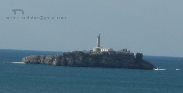
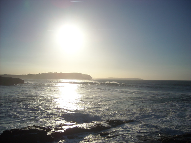
Icono Español. Icon Spanish La primavera entró el 20 de marzo. Lejos quedan los días de invierno en los que los temporales azotaban el Mar Cantábrico. El inicio de la estación trajo lluvia y la temperatura del agua rondaba los 12 grados. Conforme la Luna va cambiando de perfil, las horas de Sol han ido aumentando; calentando el agua tibiamente. En algunas fechas posteriores se han registrado temperaturas superiores a los 20 grados. Pero el mar sigue su curso y se mide por otra escala. Actualmente el agua se encuentra en 14 grados.

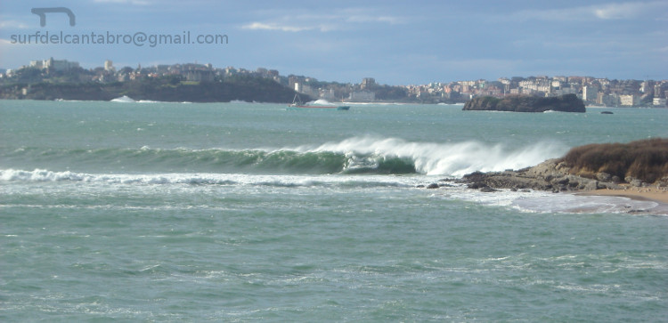
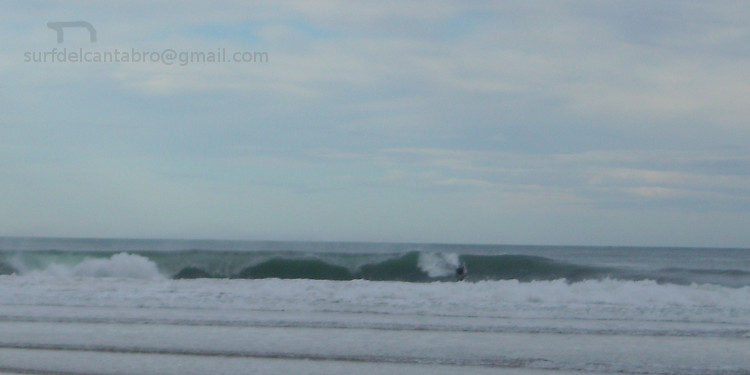
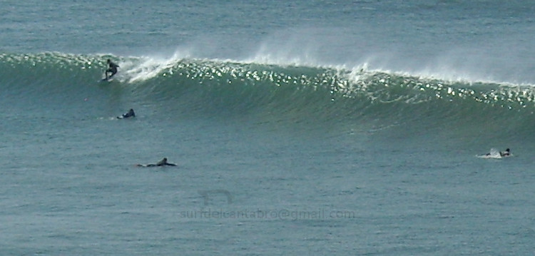
El primer fin de semana de abril paró la lluvia y el Sol se reflejaba sobre la superficie del mar. La predicción de olas estaba entre 1 y 2 metros de altura, así que el viaje hasta Somo transportaba buenas sensaciones. Pocos aparcamientos libres y mucha gente se agolpaba a lo largo del paseo que roza la arena. Los efectos del invierno que los edificios mostraban captaban la atención de los paseantes y al fondo un goteo de surfers se encaminaba a la playa con impaciencia. Nos dirigimos hacia el mismo lugar. Una especie de trance impregnaba el recorrido. El sonido de las olas iba creciendo. Al entrar en la playa vimos como una ola rizada cruzaba de izquierda a derecha. Una sonrisa y al agua.

Nacían las olas a media distancia y su trayecto se marcaba hasta la orilla. Allá que nos fuimos. Allí que llegamos. Soplaba un viento que esculpía las olas presentadolas como una pared de agua. A los cinco minutos una ola asomó a lo lejos y fue cogiendo tamaño. Cuando llegó hasta nuestra posición alcanzaba los dos metros. Remando con fuerza conseguí viajar en la cima. La cresta no cedía y mantenía el muro de agua unos metros más. La sensación de vértigo inicial disparó la adrenalina cuando fui consciente de ello. Me deslicé a la izquierda dibujando media luna. Regrese hacia la ola para chocar con la pared y volver a bajar. El agua a mi alrededor bullía. Eran las olas, era la mar, el Sol que radiaba, era la pasión que llegaba al corazón.

Somo. Spring adrenaline

Icono Inglés. Icon English The spring entered on March 20. The winter days in which the storms broke the Cantabrian Sea were far away. The beginning of the station brought rain and the temperature of the water was about 12 grades. The same way as the Moon was changing profile, the hours of the Sun had been increasing and the water was warming indifferently. In some later dates there were registered temperatures up to 20 grades. But the sea continues its course and its measures has another scale. At present the water is in 14 grades.

The first weekend of April the rain had stopped and the Sun reflected on the surface of the sea. The prediction of waves was between 1 and 2 meters in height, so the trip to Somo was carrying good sensations. Few parking free and many people lined up along the walkway that rubs against the sand. The effects of winter that the buildings showed captured the attention of passers-by. At the end of the image some surfers went to the beach with impatience. We headed toward the same place. A sort of trance permeated the tour. The sound of the waves grew. Upon entering the beach we saw as a wave curly crossing from left to right. One smile in each one and we went to the water.

The waves had borned at half distance and its trajectory was marked up to the shore. There was where we went . There was where we arrived. There was a wind that was sculpting the waves and showing it to us like a water wall. In a few minutes a wave began to be shown in the distance and it was taking size. When it came even our position was reaching two meters. Paddling strongly I managed to travel in the top. The crest was not broken and the water wall was maintaining some meters more. The sensation of initial dizziness shot the adrenaline when I realized it. I slid to the left through a maneuver like a half moon. I Returned towards the wave to ride with the wall and to went down again. The water around me was boiling. There were the waves, it was the sea, the Sun that it was lighting, it was the passion that was coming to the heart.

Separador. DividerSomo.  Surf SpringIcono separador. Icon divider

Icon close Sponsor

Share

Isla de Mouro, origen del nombre

Icono Español. Icon Spanish El origen del nombre de Isla de Mouro se remonta al siglo XVIII que es cuando se realiza el primer Atlas Hidrográfico de España. En ese libro se incluían todas las islas de nuestro páis, entre las que se encontraba la que hoy conocemos como Isla de Mouro. Su nombre original era Isla de Mogro, pero debido a un error en la transcripción hecha por el cartógrafo Vicente Tofiño de San Miguel, se registro el nombre Isla de Mouro, que se ha conservado hasta nuestros días.

La palabra «Mogro» designa a una localidad costera cantabra próxima a Santander. Su significado es sinónimo de «castro«, el cual se refiere a poblado fortificado celta, generalmente prerromano. La palabra castro proviene del latín «castrum«, que significa fortificación militar.

Island of Mouro, origin of the name

Icono Inglés. Icon English The origin of the name of the Island of Mouro goes back to the eighteenth century that is when the first Hydrographic Atlas of Spain had been done. In that book were included all the islands of our country. Among the islands, Mouro Island. Its original name was Island of Mogro, but due to an error in the transcript by the cartographer Vicente Tofino of San Miguel, the name of Island of Mouro was recorded and it has been preserved until our days.

The word «Mogro» designates a Cantabrian coastal town next to Santander. Its meaning is a synonym for «castro«, which refers to Celtic oppidum, pre-roman generally. The word castro comes from the latin «castrum«, which means military fortification.

Icon close Sponsor

Share

Isla de Mouro

Icono Español. Icon Spanish La Isla de Mouro se encuentra ubicada a la entrada de la Bahía de Santander. Está situada entre La Península de la Magdalena y la Isla de Santa Marina. Ocupa un espacio de 1,7 hectáreas. Formada por rocas que acantilan todo su contorno, en su parte alta es prácticamente llana y cuenta con un faro que en la actualidad está automatizado, llamado Faro de La Isla de Mouro.

Es un lugar ideal para practicar submarinismo por la riqueza de sus fondos. Tiene una flora abundante y variada. Destaca la presencia de una planta, el hinojo marino. Es una especie muy utilizada como condimento gastronómico. Ya en el siglo XVI los buques franceses, ingleses y flamencos en su camino de vuelta desde Santander se aprovisionaban de ella en la Isla de Mouro.

La Isla de Mouro cuenta con una población de aves que nidifican en ella. Las especies de peces que la habitan y visitan es abundante, pues a la riqueza de sus fondos marinos se añade su emplazamiento. A la entrada de la bahía y próxima a su canal. Registra una gran parte de las especies de peces que se pueden encontrar en el Mar Cantábrico.

Destaca como hecho histórico la conquista de la isla por parte de los ingleses a la tropas napoleónicas, durante la Guerra de la Independencia Española (1808 – 1814). Siendo Inglaterra aliada de España.

Mouro Island

Icono Inglés. Icon English The Mouro Island is located at the entrance to the Bay of Santander. It is placed between the Peninsula of la Magdalena and the Santa Marina Island. It occupies an area of 1.7 hectares. Formed by rocks that acantilan all around, in its upper part is virtually flat and with a lighthouse which is now automated, called Lighthouse of Mouro Island.

It is an ideal place to practise diving for the wealth of its funds. It has an abundant and varied flora. It emphasizes the presence of a plant, the marine fennel. It is a species much used as gastronomic seasoning. Already in the XVIth century the French, English and Flemish ships in its way back from Santander were supplied of it in the Island of Mouro.

The Mouro Island has a population of birds that nest in it. The species of fish that inhabit and visit it is abundant, because of the wealth of its seabed and its location. At the entrance to the bay and next to its channel. Registers a large part of the fish species that can be found in Cantabrian Sea.

Stands out as historical fact the conquest of the island by the British to the Napoleonic troops, during the Spanish War of Independence (1808 – 1814). Being England ally of Spain.

Separador. DividerIcono Español-Inglés. Icon Spanish-English
islademouro
islademouro2Icono separador. Icon divider

Icon close Sponsor

Share

El arco de las olas

Icono Español. Icon Spanish El arenal en el que está incluida la Playa de Somo tiene una extensión de 7 km. Desde el punto medio de este extenso arenal, situados en tierra firme y volviendo la mirada hacia la izquierda se encuentra la Playa del Puntal. A la derecha la Playa de Loredo. Prácticamente en todo el recorrido se puede practicar surf. Además hay varias zonas donde la frecuencia y la calidad de las olas componen un área a modo de circuito. Existen varios de estos puntos y cada uno tiene olas diferentes.

Entre la entrada principal de la Playa de Somo y la «Curva» de Loredo, la arena y el mar se dibujan en una recta de 500 metros; con un parque dunar a su espalda. Se lo conoce como Pinar de Arna. Con un pequeño parking a su entrada y separado del pinar por una valla de madera. Es un lugar ideal para realizar senderismo e ir de comida a la playa. Al fondo unas impresionantes vistas componen un cuadro único compuesto por la ciudad de Santander a un lado, la Isla de Mouro en la parte central vigilando la bahía, y la Isla de Santa Marina cerrando la composición en el otro lado. Todo ello unido por el mar. El mar que baña la tierra, las rocas y las islas. Uniendo todo el espacio y desapareciendo con la línea del horizonte.

En la entrada del parque, a la derecha de la vaya, existe un camino que conduce directamente a la playa. Delimitado por rocas dispuestas en línea recta que indican la dirección adecuada. El trayecto se hunde irregularmente y transcurre en un estado natural y salvaje. Próximo a su final, un árbol inclinado sobre el recorrido dibuja un arco cerrado por la vegetación y el entorno. Dentro de él una ventana se abre. Las olas se ven llegar y el sonido orquesta el mayor de los estímulos para practicar surf y disfrutar de la naturaleza. Sólo un desnivel de 20 metros separa el final del pinar, de la playa. Bajando por un tobogán de arena que exige precaución y buena condición física se llega a donde uno antes imaginaba.

The arc of the waves

Icono Inglés. Icon English In The arenal which is placed the Somo Beach has an extension of 7 km. From the mid-point of this extensive stretch of sand, on land and looking to the left is El Puntal Beach. To the right is Loredo Beach. In virtually all parts of the route can be surfing. In addition there are several areas where the frequency and quality of the waves make up an area by way of circuit. There are several of these points and each one has different waves.

Between the main entrance of the Playa de Somo and the «Curve» of Loredo, sand and sea are drawn in a straight line of 500 meters, with a dune park to its back. It is known as Pinar Arna. With a small parking lot to its entry and separate from the pine forest by a wooden fence. It is an ideal place for hiking and go for lunch to the beach. At the end, a breathtaking views make up a picture consisting of the city of Santander to one side, Mouro Island in the central part watching the bay, and the Santa Marina Island closes the composition on the other side. All of this kingdom is met by the sea. The sea that bathes the land, the rocks and islands. Uniting all the space and disappearing with the horizon line.

At the entrance to the park, to the right of the go, there is a path that leads directly to the beach. Bounded by rocks arranged in a straight line to indicate the right direction. The journey is irregularly and takes place in a natural and wild state. Next to its end, a tree leaning over the tour draws a bow closed by the vegetation and the environment. Within it a window opens. The waves arrive and the sound produce a powerfull stimuli for surfing and enjoy the nature. Only a drop of 20 meters separates the end of the pine forest to the beach. You can go down through a waterslide of sand that requires caution and good physical condition. Then you are going to be in a place that you have imagined before.

Separador. DividerIcono Español-Inglés. Icon Spanish-English

Arco de las Olas, a lo lejos
Arco de las Olas, entrada

Icono separador. Icon divider

Icon close Sponsor

Share

El Brusco, un espectáculo inesperado

Icono Español. Icon Spanish En estos días finales del invierno y transcurridas ya dos semanas de tiempo soleado, el recuerdo de los temporales que azotaron la cornisa cantábrica parece lejano.

Los datos meteorológicos han revelado la inusual frecuencia de temporales y ciclogenesis explosivas que se han ido sucediendo desde diciembre hasta febrero. La cantidad de agua registrada en este período duplica y casi triplica la misma cantidad recibida en doce meses en años anteriores. Las boyas oceánicas captaron con inusitada frecuencia olas de más de 10 metros y de manera no tan excepcional olas que han superado los 20 metros. En estas condiciones la práctica del surf sólo ha sido apta para profesionales y expertos.

El Sol ocultado por el clima apareció como un oasis en días sueltos. En uno de esos momentos encontré la espontaneidad del arte y el surf. Fue a finales del mes de enero. Tras haber realizado un viaje. En el camino de vuelta a Cantabria, decidí hacer una parada en El Brusco, antes de comer. Pesca, senderismo, surf, playa… Llegar y ver, pensar y sentir, cargar las pilas. Pues el mar allí armoniza la estancia. Estacioné el coche lejos del monte y me puse a andar hacia él. A lo lejos ví un grupo de gente en la arena, el agua en el otro extremo de la imagen. Mirando las olas romper la marea iba tomando volumen. Como de costumbre había buenas olas. De 3 a 6 metros de altura y con una serie practicable. Conforme iba caminando aparecieron surfistas con bodyboard que tras calentar se metieron al agua montando algarabía. Las olas aumentaban de tamaño e iban adquiriendo un recorrido largo. Al llegar al final de la playa en el agua ya había más gente y las vistas se asemejaban a un pequeño parque de atracciones. Me dispuse a subir por el sendero que corona el monte. Así contemplaría toda la escena. Pasé por delante de dos hombres que estaban quietos, mirando y pensando. Al saludarlos me parecieron gente conocida. Sin darme cuenta, por la emoción del momento, que la pasión por el surf a todos nos acerca.

Asomando a la entrada del sendero, volví la vista a la playa. Una ola de 4 metros se acercaba. Quieto, expectante, espere unos segundos que parecieron eternos. Cortando la ola desde un costado apareció un surfer con un bodyboard. La masa de agua fue cayendo y desapareció. Continué mirando esperando otra ola así. Sin saber que lo mejor estaba por llegar. Mire el otro lado de la ola que se había entubado. Vi una figura y sonreí. Salió del tubo y antes de su cierre se catapultó un par de metros en el aire. Hizo una maniobra acompañada de un grito y finalmente aterrizó en el agua.

Regrese a la playa para conversar de surf. Ya no quedaba nadie en el arenal. La figura de uno de los hombres, que antes miraba, se dirigía hacia el agua. Con dos metros de alzada y la tabla de surf sujetada en un brazo. Entró al agua fría y se perdió detrás de las olas. Poco después volví a ver aquella figura. Desde la cresta hasta la base, ondulando el recorrido. Equilibrando su peso con los brazos. Congelando toda aquella imagen en la memoria del ojo que contempla.

El Brusco, An unexpected show

Icono Inglés. Icon English In these final days of winter after two weeks of sunny weather, the remembrance of the storms that struck the Cantabrian coast seems far away.

The meteorological data have revealed us the unusual frequency of storms and explosive cyclogenesis that have been happening since December until February. The amount of water recorded in this period almost tripled the same amount received in twelve months in previous years. The oceanic buoys have captured, with unusual frequency, waves of more than 10 meters and ,in a manner not so exceptional, waves that have exceeded 20 meters. In these conditions the surfing only has been suitable for professionals and experts.

The Sun was hidden by the state of the weather and only emerged as an oasis in loose days . In one of those moments I found the spontaneity of the art and the surf. It was at the end of the month of January. After a trip. On the way back to Cantabria, I decided to make a stop at «El Brusco» before eating. Fishing, hiking, surfing, beach … Come and see, think and feel, to charge the batteries. Because the sea there harmonizes the time. I parked my car far away from the mount and I began to walk toward it. In the distance I saw a group of people in the sand, the water at the other end of the image. The tide was taking volume. As usual there was good waves. From 3 to 6 meters in height and with a practicable series. As I was walking some surfers with bodyboard were enjoying the travel to the water. The waves increased in size and became as a motorway. At the end of the beach in the water there were already more people and the views were analogous to a small amusement park. I began to go up the trail that crown the mount. I wanted to contemplate the whole scene. I passed in front of two men who were perfectly still, looking and thinking. None of us were strangers at that place. We forgot, because of the emotion of the moment, that the passion for surfing met us.

When I was at the entrance of the trail, i returned the view to the beach. A wave of 4 meters was approaching. The watchful waiting was a few seconds that seemed to last forever. By cutting off the wave from the side appeared a surfer with a bodyboard. The mass of water was falling and disappeared. I continued watching waiting for another wave as well. Without knowing that the best was to come. Look at the other side of the wave that had been entubated. I saw a figure and I smiled to myself. The surfer came out of the tube and before its closure he was catapulted two meters in the air. He made a maneuver accompanied by a cry and finally landed in the water.

I came back to the beach to talk about surfing. There was no one in the sand. The figure of one of the men that were thinking there before, were now walking toward the water. With two meters over his feet, and the surfboard in an arm. He entered the cold water and was lost behind the waves. Shortly after I returned to see that figure. From the top to the base, undulating the tour. Balancing his weight with his arms. The experience became an frozen image in the memory.

Separador. DividerIcono Español-Inglés. Icon Spanish-EnglishSurf. El BruscoIcono separador. Icon divider
Icon close Sponsor

Share

Playa de los Peligros. Origen del nombre

Icono Español. Icon Spanish «La Playa de los Peligros» se encuentra en el arenal interior de la Bahía de Santander, a la sombra de la Península de La Magdalena. Siendo esta zona el principal punto estratégico y defensivo de la ciudad, pues daba acceso a la bahía; punto de entrada a la ciudad.

Durante los siglos III y IV D.C se produjeron los ataques de los bagaudas. Ladrones y campesinos sublevados que buscaban el sustento con el pillaje. Desde esta época hasta el siglo VIII se suceden las invasiones bárbaras. Iniciadas por pueblos germánicos principalmente. Las últimas invasiones son hechas por vikingos y magiares(pueblo del este de Europa, localizado en la actual Hungría). Es Napoleón quien configura una nueva estrategia para la defensa de la península. Pudiendo ser atacada por todos los flancos y con el fin de optimizar la tarea militar dispone sus hombres en las zonas anteriores y colindantes a la península.

Todos estos hechos reflejan la imposibilidad de defender la zona completamente. Durante el siglo XIX y principios del siglo XX entran a la villa por esta playa los piratas para saquear. Por este motivo se la conoce como «Playa de los Peligros«.

Playa de Los Peligros. Origin of the name

Icono Inglés. Icon English «Los Peligros Beach» is located in the arenal that is inside of the Bay of Santander, in the shadow of the peninsula of La Magdalena. This area was the main strategic and defensive point of the city, giving access to the bay; entry point to the city.

During the centuries III and IV D. C the attacks of the bagaudas were happened. They were thieves and peasant rebels who sought the livelihood with the pillage. From this time until the eighth century there was a succession of barbaric invasions. Initiated by Germanic peoples primarily. The latest invasions are made by vikings and Magyars(groups from the eastern of Europe, located in what is today Hungary). It was Napoleon who sets up a new strategy for the defense of the peninsula. As this place may be attacked from all sides and in order to optimize the military task has its men in the previous and adjacent areas to the peninsula.

All these facts reflect the inability to defend the area completely. During the nineteenth and early twentieth century the pirates come to the city through the beach to plunder. For this reason it is known as «Los Peligros Beach«.

Icon close Sponsor

Share

El viento extremo, un motivo para una ola gigante

Icono Español. Icon Spanish. El viento extremo La fuerza extrema del viento es uno de los factores que dan lugar olas gigantes. Durante este invierno se han sucedido temporales, borrascas y ciclogénesis explosivas en el Mar Cantábrico con una frecuencia inusual. ¿ Cuál es la causa ?. Leer más … Icono. Icon

The extreme wind, a reason for a giant wave

Icono Inglés. Icon English. The extreme wind The extreme force of the wind is one of the factors that give place giant waves. This winter there have been temporary, squalls and explosive cyclogenesis in the Cantabrian Sea with an unusual frequency. What is the cause? Read more … Icono. Icon

Separador. DividerIcono Español-Inglés. Icon Spanish-English. El viento extremo. The extreme windIcono. Icon
Icono separador. Icon divider

Icon close Sponsor

Share

La península de La Magdalena: submarinismo

Icono Español. Icon Spanish La península de La Magdalena se encuentra en la ciudad de Santander. Tiene una superficie de 24,5 hectáreas. En la actualidad la península es un parque público abierto durante el día. Su horario de verano es de 8:00 a 22:00, el resto del año de 9:00 a 20:30.

En ella, están la Playa de la Magdalena, la Playa de Bikinis y la Playa de la Reina. Son zonas de aguas claras y tranquilas. Generalmente tienen poca o nula presencia de olas y es por ello que son ideales para el baño, y el disfrute de la playa. Dentro del parque se puede hacer pícnic, habiendo varias zonas con mesas habilitadas para ello. Estas zonas además si sitúan al lado de la playa.

En la propia ciudad se encuentra esta pequeña joya de la naturaleza, la península de La Magdalena. Concebida en la actualidad para el uso mundano y el disfrute divino. Destaca en ella la practica del submarinismo. El rápido y fácil acceso al lugar. Las aguas claras. La tranquilidad del mar que baña la península por el interior de la bahía. Todos estos factores propician un buceo de calidad.

Varios son los puntos de entrada para hacer submarinismo. Desde las playas de La Magdalena y Bikinis se recorre la pequeña ensenada acotada por la Isla de los ratones y el Puente de Bikinis. Desde el puente podemos rodear la isla o acercarnos al Embarcadero Real. Desde el embarcadero se realiza la travesía hacía una parte de la cara norte de la península. Situados en el acceso noreste es posible elegir alguno de los puntos anteriores o conocer los fondos marinos próximos al punto de entrada y situados bajo el Palacio de la Magdalena.

A través del buceo se descubre un paisaje submarino difícil de imaginar desde tierra. Diversidad de peces, moluscos y crustáceos nadan y caminan conforme avanzamos la ruta elegida. Lubinas, doradas, cabrachos, salmonetes y jargos conviven con distintas especies de moluscos cefalópodos como la sepia y el magano (calamar pequeño). Ambos buscan su alimento entre mejillones, lapas, caracolillos de mar y varios tipos de crustáceos. El fondo de arena blanca se entremezcla con las rocas. Rocas que forman canales y figuras, modeladas por las condiciones meteorológicas y el paso del tiempo. Son un testimonio «vivo» del pasado geológico de La Península de la Magdalena.

Separador. DividerIcono Español-Inglés. Icon Spanish-EnglishAcceso, buceo: La MagdalenaIcono separador. Icon divider

The Magdalena peninsula: scuba diving

Icono Inglés. Icon English The Magdalena peninsula is located in the city of Santander. It has an area of 24.5 hectares. At present, the peninsula is a public park open during the day. Its summer opening hours are from 8:00 to 22:00, the rest of the year from 9:00 to 20:30.

In it, are the Magdalena Beach, Bikinis Beach and The beach of the Queen. All of them are areas of clear and calm waters. Generally have little or no presence of waves so it is an ideal place for the swimming, and the enjoyment of the beach. Within the park you can picnic, having several areas with tables set aside for this purpose. These tables are near the beach.

In the city is this little gem of the nature, the «peninsula de la Magdalena». Conceived today for use worldly and the divine enjoyment. It stands out in the practice of scuba diving. The quick and easy access to the site. The crystal clear waters. The tranquility of the sea, which washes the peninsula by the interior of the bay. All these factors contribute to a quality scuba diving.

There are several entry points for diving. From the beaches of La Magdalena and Bikinis you can go to the small bay delimited by the Mice Island and the Bikinis Bridge. From the bridge we can surround the island or go to the Royal Pier. From the jetty is performed the journey toward a part of the north face of the peninsula. Located in the northeast access is possible to choose any of the above points or know the seabed near the entry point and located under the Magdalena Palace.

Through the scuba diving here you are going to discover a submarine landscape hard to imagine from the ground. Diversity of fish, molluscs and crustaceans swim and walk as we go along the route chosen. Sea Bass, golden, scoprpion fish, red mullet and jargos coexist with various species of cephalopod mollusks such as sepia and the magano (small squid). Both are looking for its food between mussels, limpets and sea snails and several types of crustaceans. The seabed of white sand is intermingled with the rocks. Rocks that form channels and figures, modeled by the weather and the passage of time. Living witnesses in the geological past of the «Peninsula de la Magdalena».

Icon close Sponsor

Share

Sucesión de temporales en la costa Cantábrica

Icono Español. Icon Spanish. Sucesión de temporales. La sucesión de temporales y borrascas en la costa cantábrica en este invierno de 2014 y durante las últimas semanas es algo fuera de lo común. Leer más … Icono. Icon

Separador. DividerIcono Español-Inglés. Icon Spanish-English. Sucesión de temporales. Succession of stormsIcono. Icon. Sucesion de temporales. Succession of stormsIcono separador. Icon divider

Succession of storms on the Cantabrian coast

Icono Inglés. Icon English The succession of storms on the Cantabrian coast in this winter of 2014 and over the past few weeks is something out of the ordinary. Read more … Icono. Icon

Icon close Sponsor

Share

Playa de Galizano: surf, submarinismo, pesca, senderismo …

Icono Español. Icon Spanish Galizano es una localidad costera cántabra que pertenece al municipio de Ribamontán al Mar. Desde Galizano se accede a sus playas y acantilados.

La playa de Arenilla es una pequeña cala de apenas 150 metros de longitud, que desaparece prácticamente en marea alta y es accesible en marea baja. Situada a la izquierda en el mapa; es apta para el baño e ideal para hacer submarinismo los días con la mar en calma. Se puede llegar hasta Langre realizando una ruta de senderísmo que conecta ambas playas. Es una zona muy buena para la pesca a surfcasting, teniendo en cuenta que esta situada en mar abierto y tomando las debidas precauciones.

La playa de Galizano tiene una configuración en forma de embudo que hace que su longitud varíe. Su arenal ocupa aproximadamente 400 metros de profundidad y es accesible siempre. El surf aquí es en crudo, salvaje, sin aditivos y con toda la potencia que impregna la naturaleza. Es necesario tener cierta pericia y nivel avanzado para practicarlo. Las olas nacen a 200 metros de la playa, siendo esta localización la ideal para hacer surf. Alejado así de las rocas se encuentra uno suspendido en el agua y esperando las olas vírgenes que trae el Mar Cantábrico. Pues no hay nada entre el mar y la Playa de Galizano que filtre el oleaje. Esto también lo convierte en una zona muy buena para la pesca recreativa a surfcasting.

Los días de temporal o fuerte oleaje prohíben la practica de cualquier actividad al aire libre que suponga la cercanía del mar. Sin embargo es en esos días cuando más se puede disfrutar de los acantilados de Galizano. Se accede a los acantilados dirigiendonos a la derecha de la playa, por una carretera que se sitúa antes de su acceso. Disfrutando del paseo, si se avanza en el camino se llega al mirador de la Cueva de «Cucabrera».

Galizano beach: surfing, scuba diving, fishing, hiking …

Icono Inglés. Icon English Galizano is a Cantabrian coastal town that belongs to the municipality of Ribamontán al Mar. From the locality is accessed to its beaches and cliffs.

The Arenilla beach is a small cove of barely 150 meters in length, that practically disappears during high tide and is accessible at low tide. Located on the left hand side in the map. It is suitable for swimming and ideal for diving the day with calm sea. You can arrive to Langre through a trekking route that connects the two beaches. It is a very good area for fishing (surfcasting), taking into account that is located in the open sea and with the proper precautions.

The Galizano beach has a configuration in the shape of a funnel that makes your length may vary. Its arenal has approximately 400 meters in depth and is always accessible. The surf here is raw, wild, without additives and with all the power that permeates the nature. It is necessary to have some expertise and advanced level for surfing. The waves are born to 200 meters from the beach, being this the ideal location to enjoy safely. Away from the rocks. the surfer is suspended in the water and waits for the original waves that brings the Cantabrian Sea. Due to there is nothing between the sea and the beach of Galizano that filter the swell. This also makes it a very good area for recreational fishing to surfcasting.

The days with bad weather or strong waves not allow us to do any outdoor activity that involves the proximity of the sea. However these are the best days when we can enjoy the cliffs of Galizano. The access to the cliffs is in the right of the beach, through a road that is placed before the parking. Enjoying the ride, if you progress on the road you will arrive to the lookout of the Cave of «Cucabrera».

Separador. Divider

Icono Español-Inglés. Icon Spanish-English Fotogafías Playa de Galizano/Galizano beach. Photographs

Ola en Galizano
Ola en GalizanoIcono separador. Icon divider

Icon close Sponsor

Share