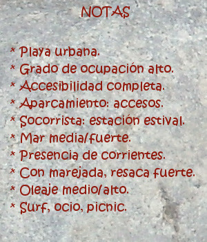
Isla de Santa Marina, lugar

Icono Español. Icon Spanish. Loredo beach La Isla de Santa Marina se encuentra al final del extenso arenal que une Somo con Loredo. En frente de la costa, separada de tierra firme por apenas 50 metros en marea baja, está una isla que tiene una extensión de 18,5 hectáreas. Formada por rocas y cubierta parcialmente de vegetación, convive con el Mar Cantábrico que la baña, golpea y moldea. Su contorno submarino se halla cubierto por rocas y pequeños arrecifes, propiciados por el efecto del mar y el clima.
El brazo de mar que la separa de la costa tiene corrientes fuertes y peligrosas, constituyendo una zona de gran interés para la práctica de la pesca recreativa y el submarinismo. Aparecen, a partir de esa separación, dos zonas diferentes en la isla que originan dos grandes olas. En la cara de la Santa Marina que mira a la Bahía de Santander, aparece una ola que abre a derechas. Cuando las condiciones del océano se endurecen, esta ola supera con facilidad los cinco metros de altura. Las factores extremos de la mar, el fondo rocoso y las corrientes hacen que la ola sólo sea aconsejada para profesionales y gente muy experimentada. En el otro lado la isla, que saluda a mar abierto, aparece una ola que abre a izquierda cuyo tamaño puede superar también los cinco metros de altura con las condiciones adecuadas. A mayor distancia de la costa, prácticamente en alta mar, las condiciones se endurecen aún más, siendo sólo apto para profesionales y gente experimentada consciente de los riesgos.

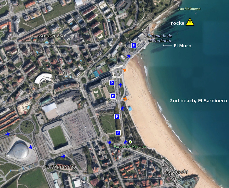
El parking que se sitúa en frente de la isla, en posición elevada, proporciona una visión panorámica de la bahía y el entorno. Desde allí se abren dos sendas que llegan por la izquierda hasta la playa de Loredo y por la derecha hasta la playa de Langre. Caminos que avanzan paralelos a la línea de costa. Acantilados y otras formaciones geológicas además de la flora y fauna existentes en los bosques cercanos acompañarán el recorrido.

Es Santa Marina una isla singular, no sólo por ser la más extensa de la costa cantábrica, pues proporciona experiencias a cualquier persona, deportista o caminante, que a ella se acerque.

comic, mountain
SantaMarina, notas

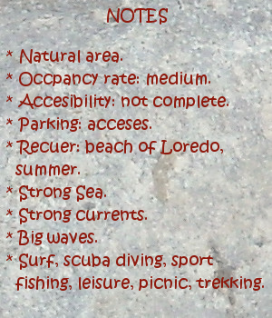
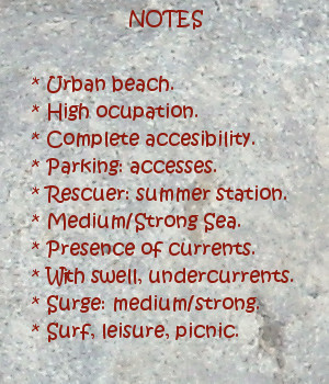
Santa Marina Island, place

Icono Inglés. Icon English. Loredo beach Santa Marina Island is placed at the end of the extensive sandbank that joins Somo with Loredo. Opposite the coast, separated from firm land by scarcely 50 meters in low tide, there is an island that has an extension of 18,5 hectares. Formed by rocks and covered partially of vegetation, it coexists with Cantabrian Sea that bathes, throbs and molds it. Its submarine contour is covered by rocks and small reefs propitiated by the effect of the sea and the climate. The inlet that separates it from the coast has strong and dangerous currents, constituting a zone of great interest for the recreative fishing and the scuba diving. Two different zones appear in the island, from this separation, that originate two big waves. In the face of the Santa Marina Island that looks towards the Bay of Santander, there appears a wave that opens to right. When the conditions of the ocean harden, this wave overcomes with facility five meters of height. Extreme conditions of the sea, the rocky bottom and the currents do that the wave only would be recomended for professionals and very experienced surfers. In the other side of the island, which greets to open sea, appears a wave that opens to left side which size can overcome also five meters of height with the suitable conditions. To major distance of the coast, practically on the high sea, the conditions harden even more, being only suitable for professionals and experienced conscious surfers of the risks.

The parking that is in front of the island, in high position, provides a panoramic vision of the bay and the environment. From there, two paths begin its travel; that come for the left side up to Loredo’s beach and for the right up to Langre’s beach. Routes that advance parallel to the line of coast. Cliffs and other geological formations besides the existing flora and fauna in the nearby forests will accompany the tour.

A singular island is Santa Marina, not only for being the most extensive of the Cantabrian coast, since it provides experiences to any person, sportsman or wayfarer, who approach it.

comic, mountain
SantaMarina, notes

Share

Loredo, playa

Icono Español. Icon Spanish. Loredo beach Loredo es una localidad cantábra, perteneciente al municipio de Ribamontán al Mar y situada al sur de la Bahía de Santander. Su playa, que recibe el nombre de la localidad, tiene una longuitud de 1200 metros y una anchura media de 60 metros. El trazado del arenal se dibuja a través de la configuración que la bahía ha proporcionado al terreno, curvando la playa en la parte contigua a Somo y extendiendo el final hasta el otro extremo; donde aparece la Isla de Santa Marina. Este peculiar dibujo da origen a una de las zonas con mayor presencia de olas en Cantábria, conocida como La Curva. Existen varios tipos diferentes de olas con distintas salidas y tamaños.

La playa alberga además el Derby de Loredo, competición hípica más antigua e importante del norte de España. Celebrada entre finales del mes de julio y principios de agosto , incluye varias categorías y es una prueba valedera para el campeonato de España y del mundo en su especialidad.

Todo el entorno de la playa está rodeado por una amplia zona verde, con formaciones dunares. El cierre de la playa se sitúa sobre terreno elevado y cercano al arenal, proporcionando una vista amplia de la bahía que culmina con la imagen de la ciudad de Santander al otro lado, o la extensión infinita del mar sobre el horizonte. Es por ello que la zona se convierte así en un lugar ideal para el ocio, el disfrute de la costa y el picnic.

comic, mountain
Loredo, notas

Loredo, beach

Icono Inglés. Icon English. Loredo beach Loredo is a Cantabrian locality, belonging to the municipality of Ribamontán al Mar and placed to the south of the Bay of Santander. Its beach, which receives the name of the locality, has a longuitud of 1200 meters and an average width of 60 meters. The tracing of the sandbank shows itself across the configuration that the bay has provided to the area, curving the beach in the contiguous part to Somo and extending it up to another end; where there appears the Santa Marina Island. This peculiar drawing gives origin to one of the zones with major presence of waves in Cantábria, known as La Curva. Several types different from waves exist with distinct exits and sizes.

The beach shelters the Derby of Loredo, the most ancient and important equine competition of the north of Spain. Celebrated between ends of July and beginning of August, it includes several categories and is a valid test for the championship of Spain and of the world in its speciality.

The whole environment of the beach is surrounded by a wide green space, with dune formations. The closing of the beach is on highland area and near to the sandbank, providing a wide sight of the bay that culminates with the image of the city of Santander to the other side, or the infinite extension of the sea on the horizon. It is for it that the zone turns this way into an ideal place for the leisure, the enjoyment of the coast and the picnic.

comic, mountain
Loredo, notes

Share

El Muro, acceso

Icono Español. Icon Sapnish. El Muro está situado en el extremo norte de la segunda playa de El Sardinero, ubicada en Santander. Esta parte central de la costa cántabra esta protegida por la ensenada que forma Cabo Menor con la Península de la Magdalena. Cuenta con dos accesos directos al arenal y varias zonas de aparcamiento.

El Muro Beach, access

Icono Inglés. Icon English. El Muro is placed in the north end of the second beach of The Sardinero, located in Santander. This central part of the Cantabrian coast is protected by the inlet that forms Cape Menor with the Peninsula of La Magdalena. It possesses two direct accesses to the sandbank and several zones of parking.

Icono español-inglés. Icon Spanish-English. Acceso/Access

El Muro, access

Share

El Muro, localización

Icono Español. Icon Spanish El Muro está situado en el extremo norte de la segunda playa de El Sardinero, en Santander. Es la parte final de una playa urbana que cuenta con todos los servicios. Se muestran a continuación como puntos de partida: Oviedo, Palencia, Santander y Bilbao. Comenzando el viaje por autovía y finalizando el recorrido por la misma carretera nacional en todos los trayectos.

El Muro, localization

Icono Inglés. Icon English El Muro is placed in the north end of the second beach of El Sardinero, in Santander. It is the final part of an urban beach that has all the services. Shown below as starting points: Oviedo , Palencia , Santander and Bilbao . Beginning the trip for motorway and finishing the tour for the same national road in all the options.

Icono Español-Inglés. Icon Spanish-English Localización/Localization

Oviedo, El Muro: LocalizationPalencia, El Muro: LocalizationBilbao, El Muro: LocalizationSantander, El Muro: localization

Share

Pedreña, acceso

Icono Español. Icon Spanish. Pedreña, acceso surf area Pedreña es una localidad situada en la parte sur de la Bahia de Santander, perteneciente al municipio de Marina de Cudeyo. Cuenta con una nueva zona habilitada para practicar Paddle surf y Kitesurf. Dispone de un pequeño aparcamiento a la entrada del área.

Pedreña, access

Icono. Icon. Pedreña, access surf area Pedreña is a locality placed in the south part of the Bay of Santander, belonging to the municipality of Marina de Cudeyo. It possesses a new zone enabled to practise Paddle surf and Kitesurf. There is an small parking at the entry of the area.

Icono Español-Inglés. Icon Spanish-English. Pedreña, access surf area Acceso/Access

Pedreña, access

Share

Pedreña, localización

Icono Español. Icon Spanish Pedreña es una localidad costera cántabra, perteneciente al municipio de Marina de Cudeyo; y situada en la parte sur de la Bahía de Santander. Desde la localidad se accede a una zona habilitada por el ayuntamiento para practicar paddle surf y kitesurf. Debido a que el acceso a este circuito es de nueva construcción no aparece aún en las guías oficiales, por ello continuaremos el viaje hacia el Barrio El Muelle; siguiendo la carretera. A cincuenta metros del Barrio El Muelle y en el lado izquierdo de la vía, donde la carretera gira a la derecha 180 grados para seguir hasta Somo, está la entrada al circuito. Se muestran a continuación como puntos de partida: Oviedo, Palencia, Santander y Bilbao. Comenzando el viaje por autovía y finalizando el recorrido por la misma carretera nacional en todos los trayectos.

Pedreña, localization

Icono Inglés. Icon English Pedreña is a Cantabrian coastal locality, belonging to the municipality of Marina de Cudeyo; and placed in the south part of the Bay of Santander. From the locality you can access to a zone enabled by the town hall to practise paddle surf and kitesurf. Due to the fact that the access to this circuit is of new construction it does not appear still in the official guides, so we will continue the trip towards the Neighborhood El Muelle; following the road. To fifty meters of that neighborhood and in the left side of the route, where the road turns to the right 180 degrees to continue up to Somo, is the entry to the circuit. Shown below as starting points: Oviedo , Palencia , Santander and Bilbao . Beginning the trip for motorway and finishing the tour for the same national road in all the options.

Icono Español-Inglés. Icon Spanish-English Localización/Localization

Oviedo, Pedreña: LocalizationPalencia, Pedreña: LocalizationBilbao, Pedreña: LocalizationSantander, Pedreña: localization

Share

El Madero, Liencres. Acceso

Icono Español. Icon Spanish. Puerto Calderón, acceso La playa El Madero está situado en la localidad de Liencres, perteneciente al municipio de Piélagos. Es la playa más oriental del extenso arenal. Atrevesando el Parque natural de las Dunas de Liencres, a mano derecha de la carretera, llegamos al primer aparcamiento, de los dos que hay en la zona. La entrada a la playa de Canallave sirve de acceso a El Madero, situado al fondo.

El Madero, Liencres. Access

Icono. Icon. Calderón Port, access El Madero beach is placed in the locality of Liencres , belonging to the municipality of Piélagos. It is the most oriental beach of the extensive sandbank. Crossing the road of the Nature Reserve of Liencres’s Dunes, to right hand of the road, we come to the first parking, of the two that exist in the zone. The entry to the beach of Canallave is used as access to El Madero, placed at the end.

Icono español-inglés. Icon Spanish-English. Calderón Puerto, Port; acceso/access Acceso/Beach Access

Access, El Madero

Share

EL Madero, Liencres. Localización

Icono Español. Icon Spanish La playa El Madero está situada en la localidad de Liencres, perteneciente al municipio de Piélagos. Es la playa más oriental de Liencres. Se muestran a continuación como puntos de partida: Oviedo, Palencia, Santander y Bilbao; como puntos de partida, todos los demás orígenes atraviesan por uno o varios de estos puntos. La llegada a las playas de Liencres no es está indicada en las guías oficiales, es por ello que la ruta finaliza en el Barrio Callejo de liencres. Llegando desde Oviedo o Palencia encontramos la entrada a las playas antes de llegar al Barrio Callejo. Desde los demás puntos de partida debemos continuar la carratera hasta llegar al Parque natural de las Dunas de Liencres. La entrada esta bien señalizada.

El Madero, Liencres. Localization

Icono Inglés. Icon English El Madero beach is located in the town of Liencres, belonging to the municipality of Piélagos. It is the most eastern beach of liencres. Shown below as starting points: Oviedo, Palencia, Santander and Bilbao; as points of departure, all other origins run through one or more of these points. The arrival to Liencres’s beaches is not is indicated in the official guides, is for it that the route finishes in the Neighborhood Callejo of liencres. Coming from Oviedo or Palencia we find the entry to the beaches before arriving to the Neighborhood Callejo. From other points of item we must continue the road up to coming to the Nature Reserve of Liencres’s Dunes. The entry is well indicated.

Icono Español-Inglés. Icon Spanish-English Localización/Localization

Oviedo, El Madero: LocalizationPalencia, El Madero: LocalizationBilbao, El Madero: LocalizationSantander, El Madero: Localization

Share

El Camello, acceso

Icono Español. Icon Spanish. El Camello, acceso La playa de El Camello, situada en la ciudad de Santander, es un pequeño arenal en cuyas aguas alberga un arrecife rocoso de formas variopintas. Tiene dos accesos, acompañados de sendos aparcamientos. Apta para el baño y el ocio, es ideal para practicar submarinismo. Su fondo rocoso y la presencia de corrientes aconsejan realizar el buceo con las debidas precauciones.

El Camello, access

Icono. Icon. El Camello, access The beach of El Camello, placed in the city of Santander, is a small sandbank in whose waters it shelters a rocky reef with multiple and different forms. It has two accesses, accompanied of parkings. Suitable for the swimming and the leisure, it is ideal to practise scuba diving. Its rocky bottom and the presence of currents advise to realize the diving with the due precautions.

Icono español-inglés. Icon Spanish-English. El Camello, acceso/access Acceso/Beach Access

El Camello, access

Share

El Camello, localización

Icono Español. Icon Spanish La playa de El Camello está situada en la ciudad de Santander. Es una pequeña playa con abundante presencia de rocas y peculiar configuración. Sus características la convierten en una zona especial para practicar submarinismo, además del ocio y la pesca.Se puede llegar a esta playa desde Oviedo, Palencia, Santander o Bilbao.

El Camello, Localization

Icono Inglés. Icon English The beach of El Camello is placed in the city of Santander. It is a small beach with abundant presence of rocks and peculiar configuration. Its characteristics turn it into a special zone to practise scuba diving, besides the leisure and the fishing. It is possible to arrive to this beach from Oviedo, Palencia, Santander or Bilbao.

Icono Español-Inglés. Icon Spanish-English Localización/Localization

Oviedo, El_Camello: surf tourPalencia, El Camello: surf tourBilbao, El Camello: surf tourSantander, EL Camello: surf tour

Share