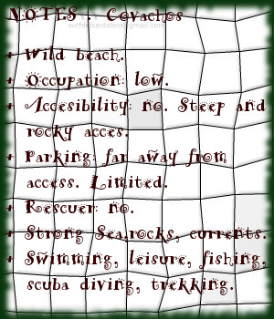
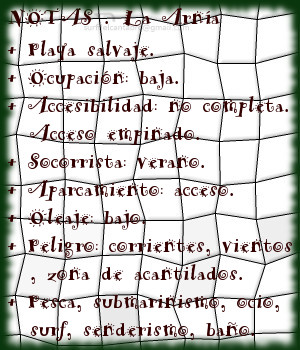
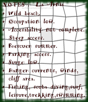
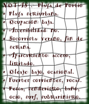
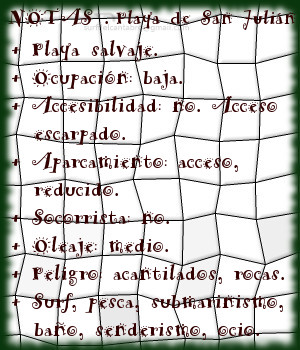
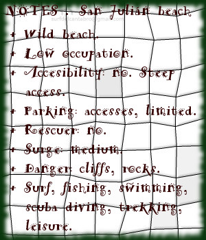
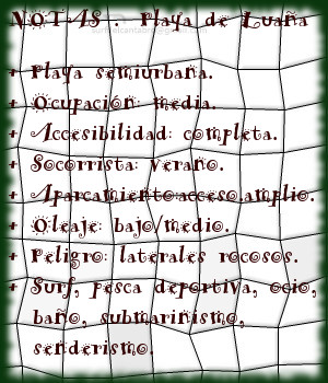
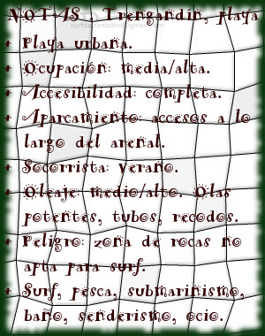
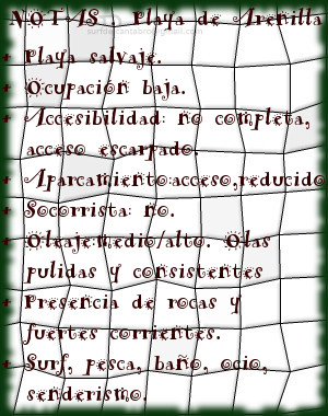
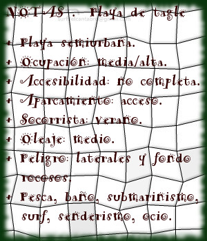
Covachos, playa

Icono Español. Icon Spanish. Covachos, playa La playa de Covachos se encuentra en la localidad de Soto de la Marina, perteneciente al municipio de Santa Cruz de Bezana; en la costa central de Cantabria. Esta especial cala, emplazada en un entorno idílico, tiene una longitud aproximada de 300 metros y 20 metros de anchura media que se distribuyen en dos pequeñas calas separadas en marea alta. La bajamar descubre completamente la playa, apareciendo un arenal con forma de media luna que conecta la línea de costa con la Isla del Castro a través de su fina y dorada arena.

Los acantilados de Covachos, curvan su recorrido y contienen al arenal. Desde ese anfiteatro y a mano derecha, continua la playa paralela a la costa. La Isla del Castro delimita su parte final y dispone dos vertientes para el disfrute. La primera zona que da a la ensenada, formada por el entorno, es una zona tranquila y protegida del Mar Cantábrico. La zona este da entrada a las aguas de mar abierto.

El descanso sobre la arena de Covachos relaja al caminante. La contemplación de su entorno oxigena el ánimo a través de la catarsis producida por la naturaleza y su arte. El inicio se convierte en final y la perspectiva cambia a cada paso, pues en pocos metros aparecen muchas posibilidades.

El acceso elevado y escarpado que desciende hasta la arena, la presencia de rosas y las corrientes que rigen las mareas de la zona aconsejan precaución en Covachos y permitir así que la zona capture la atención que el paso del tiempo hará permanecer en el recuerdo.
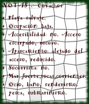
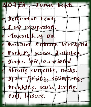
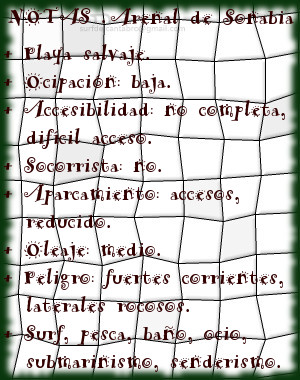
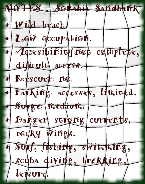
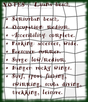
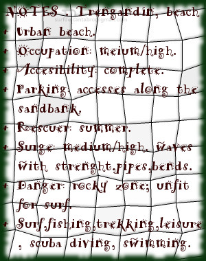
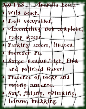
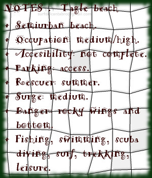
Cabecera Cities Place Beaches. Covachos, playa
Covachos, Notas

Covachos, beach

Icono Inglés. Icon English. Covachos, beach The beach of Covachos is in the locality of Soto de la Marina, belonging to the municipality of Santa Cruz de Bezana; on the central coast of Cantabria. This special cove located in an idyllic environment, has an approximate length of 300 meters and 20 meters of average width that are distributed in two small coves separated in high tide. The low tide discovers completely the beach, appearing a sandbank with form of half moon that connects the line of coast with the Island of the Castro across its thin and golden sand.

The cliffs of Covachos curl its tour and contain to the sandbank. From this amphitheatre, to right side, the beach continues parallel to the coast. The Island of the Castro delimits its final part and arranges two slopes for the enjoyment. Its first zone that gives to the inlet formed by the environment, is a calm zone protected from the Cantabrian Sea. The east zone gives entry to the waters of open sea.

The repose on Covachos’s sand relaxes the wayfarer. The contemplation of its environment oxygenates the spirit across the catharsis produced by the nature and its art. The beginning turns in end and the perspective changes to every step, since in few meters many possibilities appear.

The slope and steep access that descends up to the sand, the presence of rocks and the currents that govern the tides of the zone, advise precaution in Covachos and so to allow the zone capture the attention that the passage of time will make remain in the recollection.

Cabecera Cities Place Beaches. Covachos, beach
Covachos, Notes

Share

La Arnía, playa

Icono Español. Icon Spanish. La Arnía, playa La playa de la Arnía se encuentra en la localidad de Liencres, perteneciente al municipio de Piélagos; en la costa central de Cantabria. Su arenal de reducido tamaño, 150 metros de longitud y 50 metros de anchura media, da entrada a un área mayor delimitada por acantilados que parcialmente filtran y modulan el oleaje.

La línea de costa, situada en el ala derecha de la playa, define la extensión de La Arnía. El ala izquierda dispone de un escarpe rocoso, resto erosionado de la arcaica costa cántabra, que protege parte de la pequeña ensenada. Esta formación, debido al efecto del Mar Cantábrico, redefine su figura tanto sobre el nivel del mar como en su plataforma base. El acceso se realiza a través de una empinada cuesta. Precediendo a La Arnía, desde la rampa de entrada y a su lado izquierdo, se encuentra un entorno formado por rasa mareal, acantilados y otras formaciones geológicas de singular belleza.

El oleaje es generalmente fuerte, siendo hábil para practicar surf cuando su tamaño es medio-bajo. Las fuertes condiciones de la zona y las limitadas dimensiones de la playa condicionan la navegación. Destacan los fondos marinos, que con el mar en calma suponen un disfrute para los sentidos.

Cabecera Cities Place Beaches. La Arnía, playa
La Arnia, Notas

La Arnía, beach

Icono Inglés. Icon English. La Arnía, beach The beach of La Arnía is in the locality of Liencres, belonging to the municipality of Piélagos; on the central coast of Cantabria. Its sandbank of limited size, 150 meters of length and 50 meters of average width, gives entry to a bigger area delimited by cliffs that partially leak and modulate the surge.

The line of coast, placed in the right wing of the beach, defines the extension of La Arnía. The left wing has one scarp rocky, eroded rest of the archaic Cantabrian coast, which protects part of the small inlet. This formation, due to the effect of the Cantsabrian Sea re-defines its figure so much on the level of the sea as in its base platform. The access is realized across an steep slope. Preceding La Arnía, from the ramp of entry and its left side, finds an environment formed by level mareal, cliffs and other geological formations with singular beauty.

The waves are generally strong, being adept at surfing when its size is medium-low. The strong conditions in the area and the limited dimensions of the beach condition the navigation. Highlights the seabed, posed a treat for the senses with the calm sea.

Cabecera Cities Place Beaches. La Arnía, beach
La Arnia, Notes

Share

Portio, playa

Icono Español. Icon Spanish. Portio, playa La playa de Portio se encuentra en la localidad de Liencres, perteneciente al municipio de Piélagos, en la costa central de Cantabria. Es una pequeña playa, de 150 metros de longitud y 40 metros de anchura media, a modo de cala y situada dentro de una ensenada formada por la erosión del mar en esta parte de la costa.

La ensenada que comparte Portio con otras playas, a pesar de tener un entorno urbanizado, dispone de gran riqueza paisajística, geológica y marina. Protegida por grandes rocas dispuestas verticalmente, rodeada por acantilados y con fondos esculpidos sobre pliegues de rocas erosionados, conserva su estado natural y salvaje. La disposición de la playa en mar abierto hace que reciba las corrientes marinas de la zona. Los de urros que se encuentran a la entrada de la ensenada cercenan el oleaje cuya dirección choca contra las rocas resultando sus olas de tamaño medio, bajo y de carácter ocasional.

La practica de surf en Portio se reserva a una experiencia puntual cuando las olas traigan buenas condiciones y el estado del mar lo permita. Otras actividades como la pesca y el buceo encuentran en la playa de Portio un marco incomparable. Su oferta geológica y el trasiego que el mar hace en la zona, favorecen la diversidad de especies marinas. Los rincones que aparecen a cada paso irán redibujando la playa, consumiendo nuestro tiempo a través de su historia.

Cabecera Cities Place Beaches. Portio, playa
Portio, playa . Notas

Portio, beach

Icono Inglés. Icon English. Portio, beach The beach of Portio is in the locality of Liencres, belonging to the municipality of Piélagos, on the central coast of Cantabria. It is an small beach, with 150 meters of length and 40 meters of average width, like a cove and placed inside an inlet formed by the erosion of the Sea in this part of the coast.

The inlet that Portio shares with other beaches, in spite of having an urbanized environment, has great landscape, variety geological and marine . Protected by big rocks arranged vertically, surrounded by cliffs, and sculpted seabed on rock folds eroded, preserves its natural and wild condition.

The practice of surf in Portio is reserved to a punctual experience when the waves may have have good conditions and the features of the sea allows it. Other activities like fishing and scuba diving find in Portio’s beach an incomparable frame. Its geological offer and the decanting that the sea does in the zone, favor the diversity of marine species. The nooks that appear in every step will re-drawing the beach, consuming our time across its history.

Cabecera Cities Place Beaches. Portio, beach
Portio, beach. Notes

Share

San Julián, playa

Icono Español. Icon Spanish. San Julián, playa La playa de San Julián se encuentra en la localidad y municipio de Liendo, situado en la costa oriental de Cantabria. Sus reducidas dimensiones, 100 metros de longitud y 20 metros de anchura media, descubren una cala salvaje y recogida entre acantilados que se emplaza en la Ensenada de la Yesera.

La Punta de El Ahorcado, sobresaliendo en la línea de costa, delimita la parte izquierda del arenal y cobija a San Julián; que se encuentra en el recodo que forma la costa con la cara este de la punta. Hacia la derecha de la playa ,se abre la ensenada; extendiendo el área de influencia de la playa. La punta de Yesera acota la zona en su ala derecha. Destaca, antes de su extremo, la Punta El Orao; un pequeño cabo que proporciona una perspectiva del entorno y da acceso a una zona de mar abierto con fondo marino diverso y rocoso.

La arena oscura y gruesa revela el origen del arenal que la fuerza del Mar Cantábrico y los acantilados del Monte Candina han ido formando a través de los siglos. El oleaje, modulado por el entorno, es moderado; con olas de pequeño recorrido que abren a ambos lados. La vista desde el agua de los acantilados, el verdor de los prados y el olor del mar suspendido en el aire, quizás nos transporte a otro tiempo.

Cabecera Cities Place Beaches. San Julián, playa
San Julian, beach. Notas

San Julián, beach

Icono Inglés. Icon English. San Julián, beach The beach of San Julián is in the locality and municipality of Liendo, placed in the oriental coast of Cantabria. Its limited dimensions, 100 meters of length and 20 meters of average width, discover a cove wild and secluded between cliffs that are located in the Inlet of Yesera.

El Ahorcado Tip, standing out in the line of coast, delimits the left part of the sandbank and shelters San Julián that is in the bend that the coast forms with the east face of the tip. Towards the right of the beach, the inlet is opened and extends the influence area of the cove. The Yesera Tip annotates the zone in its right wing. Stands out, before its end, El Orao Tip; an small end that provides a perspective of the environment and leads to a zone of open sea with diverse and rocky sea bed.

The dark and coarse sand reveals the origin of the sandbank that the force of the Cantabrian Sea and the cliffs of the Mount of Candina have been forming across the centuries. The surge, modulated by the environment, is moderate; with waves of small tour that open to both sides. The sight from the water of the cliffs, the greenery of the meadows and the smell of the sea suspended in the air, would probably transport us to another time.

Cabecera Cities Place Beaches. San Julián, beach
San Julian, beach. Notes

Share

Arenal de Sonabia, playa

Icono Español. Icon Spanish. Arenal de Sonabia, playa El Arenal de Sonabia se encuentra en la localidad de Sonabia, perteneciente al municipio de Liendo. Esta localidad, próxima a Oriñón, concentra en sus cercanías un entorno único que aumenta la belleza de su playa. Siendo su medioambiente su adorno, es la cala y sus olas su contenido para los amantes del surf.

La llegada al arenal se realiza por un escarpado acceso, existiendo varios senderos peatonales. La contemplación de la cala, con 150 metros de longitud y 80 metros de anchura media, destaca el contraste del macizo que la resguarda con las aguas del Mar Cantábrico que la bañan. El Monte Candina protege a la playa y configura la morfología del entorno natural, destacando en la línea de costa y modulando el oleaje que llega hasta Sonabia. La Punta de Yesera, situada a la izquierda, y la Punta Lanzadoiro, a la derecha, delimitan el área norte de la costa de Sonabia ampliando la zona más allá de la playa.

Destaca la arena fina, la calidad de sus aguas y la pendiente que dirige los pasos del caminante hacia el mar. Las olas abren a ambos lados, predominando a izquierdas. Entra el mar con fuerza, la orientación noroeste de la playa permite recoger el oleaje y las corrientes que arriban, por lo que se exige buena condición física. Evitando los laterales rocosos del arenal podremos disfrutar de una de las pocas playas salvajes de Cantabria.

Cabecera Cities Place Beaches. Arenal de Sonabia, playa
Arenal de Sonabia, playa. Notas

Sandbank of Sonabia, beach

Icono Inglés. Icon English. Sonabia Sandbank, beach The Sandbank of Sonabia is in the locality of Sonabia, belonging to the municipality of Liendo. This locality, next Oriñón, concentrates in its surroundings an unique environment that increases the beauty of its beach. Being its environment the adornment, it is the cove and the waves; its content for the lovers of surf.

The arrival to the sandbank is realized by an steep access, there are several pedestrian paths. The contemplation of the cove, with 150 meters of length and 80 meters of average width, stands out the contrast of the massif, that protects it, with the waters of the Cantabrian Sea that meets it. The Mount Candina protects the beach and designs the morphology of the natural environment, protruding in the line of coast and modulating the surge that comes up to Sonabia. The Yesera Tip, placed to the left side, and the Lanzadoiro Tip, to the right, delimit the north area of Sonabia’s coast that is extending the zone beyond the beach.

Stands out the thin sand, the quality of its waters and the slope that directs the steps of the wayfarer to the sea. The waves open to both sides, highlighting the left side. It enters the sea strongly, the orientation northwest of the beach allows to gather the surge and the currents that arrive, for what it is required good physical condition. Avoiding the rocky wings of the sandbank, we will be able to enjoy one of few wild beaches of Cantabria.

Cabecera Cities Place Beaches. Sonabia Sandbank, beach
Sonabia Sandbank, beach. Notes

Share

Luaña, playa

Icono Español. Icon Spanish. Luaña, playa La playa de Luaña está situada en la localidad de Cóbreces, perteneciente al municipio de Alfoz de lloredo, en la costa occidental de Cantabria. También es conocida como playa de Cóbreces. El área que ocupa la playa dentro de la Ensenada de Luaña tiene una longitud de 400 metros y anchura de 70 metros.

La orientación noreste de la playa de Luaña hace que el oleaje de la zona se encamine hacia la Punta de la Rebollera, produciendo sobre la cala la modulación de las olas. El fondo de arena, la suavidad del oleaje y la protección de los acantilados la convierten en una playa ideal para noveles y surfers que quieran mejorar la técnica cuando el oleaje es medio/bajo. Los días con mar fuerte las olas pueden superar los 4 metros de altura, siendo aconsejable la practica de surf para navegantes experimentados. Esta playa tiene olas prácticamente todo el año, los mayores registros se dan en otoño e invierno. Abren sus ondas a ambos lados, destacando su izquierda y evitando la cercanía de los acantilados.

La llegada a la playa de Luaña produce en el caminante sensaciones de lenta y suave digestión que la partida terminará de asentar. La estancia allí, impregnada por la belleza sencilla y seminatural del especial arenal, harán que el disfrute olvide por un intervalo la medición del tiempo.

Cabecera Cities Place Beaches. Luaña, playa
Luaña, playa. Notas

Luaña, beach

Icono Inglés. Icon English. Luaña, beach The beach of Luaña is placed in Cóbreces, belonging locality to municipality of Alfoz de lloredo, on the western coast of Cantabria. Also it is known as Cóbreces’s beach. The area that occupies it inside the Inlet of Luaña has a length of 400 meters and width of 70 meters.

The orientation North-East of the beach of Luaña does that the surge of the zone would be directed towards the Tip de la Rebollera, producing on the cove the modulation of the waves. The bottom of sand, the smoothness of the surge and the protection of the cliffs turn it into an ideal beach for starters and surfers that want to improve the technique when the surge is low/medium. The days with strong sea, the waves can overcome 4 meters of height, being advisable the practice of surf for experienced navigators. This beach has waves practically all the year round, the major records are given in autumn and winter. Open its waves for both sides, emphasizing its left side and avoiding the nearness of the cliffs.

The arrival to Luaña produces, in the wayfarer, sensations of slow and soft digestion; that the homecoming will process. The stay there, impregnated by the simple and seminatural beauty of the special sandbank, will do that the enjoyment forgets for an interval the measurement of the time.

Cabecera Cities Place Beaches. Luaña, beach
Luaña, beach. Notes

Share

Trengandín, playa

Icono Español. Icon Spanish. Trengandín, playa La playa de Trengandín está ubicada en el municipio de Noja, en la costa oriental de Cantabria. Es uno de los arenales más extensos de la costa cántabra con una longitud de 6000 metros y una anchura media aproximada de 100 metros. Debido a sus dimensiones, contiene varias zonas diferenciadas.

La primera parte de la playa, situada de zona urbana de la villa, tiene forma curva e irregular. Sus aguas repletas de afiladas rocas forman un espectacular paisaje en marea baja. Es una área adecuada para el ocio, baño, submarinismo, no siendo apta para practicar surf, pues las formaciones rocosas inundan la zona y sobresalen por encima del agua. El siguiente tramo que comienza en el Barrio de Helgueras y corre paralelo a los Montes de Mijedo, recibe el nombre de playa de Helgueras. Ocupada hasta la mitad del recorrido por rocas que van desapareciendo hasta encontrar la otra mitad libre y limpia de obstáculos para la práctica del surf. Su parte final, próxima al Monte EL Brusco, es conocida como El Brusco.

El Mar Cantábrico ingresa en la Ensenada de Noja superando la Punta de la Mesa, filtrando el oleaje, que se proyecta hacia la línea de costa. Recibe Helgueras olas que abren a izquierdas, con tamaño medio-alto, y alcanzan largo recorrido. El otoño, que registra mareas grandes, propicia olas de mayor tamaño. Desplazando las masas de agua sobre la ensenada, con suave pendiente y altura superior a los tres metros, aparecen tubos y navegaciones prolongadas. Existen otros picos de olas en la zona que abren a ambos lados y favorecen las maniobras.

Cabecera Cities Place Beaches. Trengandín, playa
Trengandin, playa. Notas

Trengandín, beach

Icono Inglés. Icon English. Trengandín, beach The beach of Trengandín is located in the municipality of Noja, on the oriental coast of Cantabria. It is one of the most extensive sandbanks of the Cantabrian coast with a length of 6000 meters and an average approximate width of 100 meters. Due to its dimensions, it contains several differentiated zones.

The first part of the beach, placed on urban zone of the villa, has a curved and irregular form. Its waters replete with sharp rocks form an spectacular landscape in low tide. It is an area adapted for the leisure, swimming, scuba diving, not being suitable to practise surf, since the rocky formations flood the zone and stand out over the water. The following section that begins in the Neighborhood of Helgueras and runs parallel to the Mounts of Mijedo, receives the Helgueras’s beach name. Occupied up to the half of the tour by rocks that disappear up to finding the second free and clean area of obstacles for the practice of the surf. Its final part, next the Mount El Brusco, is known as El Brusco.

The Cantabrian Sea enters in the Inlet of Noja overcoming the Mesa Tip, filtering the surge, which is projected towards the line of coast. Helgueras receives waves that open to left side, with medium-high size, and reach crossed length. The autumn, which registers big tides, propitiates waves of major size. The movement of the water masses in the inlet, with soft earring and height superior to three meters, brings up pipes and long navigations. Other beaks of waves exist in the zone that open for both sides and propitiates the maneuvers.

Cabecera Cities Place Beaches. Trengandín, beach
Trengandin, beach. Notes

Share

Playa de Arenilla. Galizano

Icono Español. Icon Spanish. Playa Arenilla. Galizano La Playa de Arenilla está situada en la localidad de Galizano, perteneciente al municipio de Ribamontán al Mar. Emplazada en la costa central de Cantabria se ubica entre las playas de Langre y Galizano. Es una pequeña cala que apenas supera los 100 metros de longitud, su anchura en bajamar es de 50 metros y queda totalmente cubierta con la marea alta.

Arenilla en su mitad contigua al mar se compone de arenilla gruesa, con cuerpo, al contacto con el pie se mastican las pisadas. Su otra mitad, situada bajo el acantilado y con forma de U, está repleta de rocas apiladas, rozadas por el mar, que permiten sobre ellas un andar hábil. La parte derecha y superior del acantilado abre un sendero improvisado entre las rocas que llega hasta la playa de Galizano. El lado izquierdo y superior se comunica con la playa de Langre por medio de un camino agrícola. Su difícil localización y pedregoso acceso dan muestra de la naturaleza salvaje de la cala.

Las alas rocosas del acantilado amontonan rocas sueltas en su base, decorando su entrada al agua. La corriente fuerte exige buena condición física y la atención para evitar los laterales, con una pared frontal de roca estratificada en un lado y en el otro las corrientes circulares de la playa contigua; Langre. El frontal, situado en dirección decreciente hacia la cala, recibe una ola de derechas solo apta para surfers experimentados. La parte central, con su base profunda de roca y cubierta por gruesa arena metros por encima, crea una ola pulida, que abre a ambos lados y a veces solapa una ola de izquierdas tornando esta misma en derechas. De buena potencia y altura, traslada el agua limpia y con el ritmo adecuado para convertir la navegación en toda una experiencia que pueda reflejar por un instante la autenticidad del Mar Cantábrico y su costa.

Cabecera Cities Place Beaches. Playa de Arenilla. Galizano
Playa de Arenilla. Galizano , notas

Arenilla beach. Galizano

Icono Inglés. Icon English. Arenilla beach. Galizano The Beach of Arenilla is placed in the locality of Galizano, belonging to the municipality of Ribamontán al Mar. Located on the central coast of Cantabria it is situated between the beaches of Langre and Galizano. It is an small cove that scarcely overcomes 100 meters of length, its width in low tide is 50 meters and remains totally covered with the high tide.

Arenila in its half contiguous to the Sea consists of thick sand, bodied, to the contact with the foot the steps are chewed. Its another half, placed under the cliff and with form of U, is replete with rocks piled up, rubbed by the sea, which allow on them one who walks skilfully. The right and top part of the cliff opens an improvised path between the rocks that comes up to Galizano’s beach. The left and top side communicates with Langre’s beach through an agricultural way. Its difficult location and stony access give sample of the wild nature of the cove.

The rocky wings of the cliff accumulate free rocks in their base, decorating its entry to the water. The strong currents demand good physical condition and the attention to avoid the wings, with a frontal wall of rock stratified in a side and in other one the circular currents of the contiguous beach; Langre. The frontal, placed in diminishing direction towards the cove, receives a right wave only suitable for experienced surfers. The central part, with its deep base of rock and covered by thick sand meters, creates a polished wave, which opens to both sides and, sometimes it overlaps a left wave turning itself into a right wave. Of good power and height, it moves the clean water and with the pace adapted to turn the navigation into the whole experience that could reflect for an instant the genuineness of the Cantabrian Sea and its coast.

Cabecera Cities Place Beaches. Arenilla beach. Galizano
Arenilla, notes

Share

Tagle, playa

Icono Español. Icon Spanish. Tagle, playa La playa de Tagle, llamada Playa El Sable, se encuentra en la localidad de Tagle, perteneciente al municipio de Suances, en la costa occidental de Cantabria. El arenal de 200 metros de longitud y 50 metros de ancho, está precedido por un gran aparcamiento que es ocupado totalmente en la estación estival.

La llegada a la playa de Tagle encuentra una cuesta con una pendiente suave, cada paso del caminante se ve ayudado por la inclinación. Poco a poco la zona aumenta su anchura para ir descubriendo la playa, sus laterales, las rocas dispersas dentro de sus aguas. El sonido del Mar Cantábrico, chocando con la Playa EL Sable, entona una melodía que expresa el carácter de la unión entre ambos. Música suave y atrayente ó violenta y natural, ambos estados registra la playa de Tagle.

Los laterales y fondo rocoso la convierten en una playa peligrosa para la práctica del surf. La zona hábil para navegar se encuentra alejada de la línea de costa, evitando las zonas rocosas y situada fuera de la ensenada que forma la playa con el entorno. Las rocas que restan en la zona constituyen la base de la prehistórica y ancestral costa. El efecto de la fuerza del oleaje y las grandes mareas han ido erosionando y afilando los acantilados que son los vestigios que ahora quedan, a modo de entorno rocoso.

Cabecera Cities Place Beaches. Tagle, playa
Tagle, notas

Tagle, beach

Icono Inglés. Icon English. Tagle, beach Tagle’s beach, also called Beach El Sable, is in the locality of Tagle, belonging to the municipality of Suances, on the western coast of Cantabria. The sandbank of 200 meters of length and 50 meters of width, is preceded by a great parking which is totally occupied on the summer station.

The arrival to Tagle’s beach finds a slope with a soft slope, every step of the wayfarer meets helped by the inclination. Little by little the zone increases its width to discover the beach, its wings, the dispersed rocks inside its waters. The sound of the Cantabrian Sea, shocking the Beach El Sable, intones a melody that expresses the character of the union between them. Soft and attractive music or violent and natural, both conditions are register in Tagle’s beach.

The wings and bottom turn her into a dangerous beach for the practice of the surf. The skilful zone to sail is removed from the coast line, avoiding the rocky areas and placed out of the inlet that forms the beach with the environment. The rocks that remain in the zone constitute the base of the prehistoric and ancient coast. The effect of the force of the surge and the big tides have been eroding and sharpening the cliffs that are the vestiges that now stay, like rocky environment.

Cabecera Cities Place Beaches. Tagle, beach
Tagle, notes

Share

El Rosal, playa

Icono Español. Icon Spanish. El Rosal, playa La playa El Rosal, también conocida como Tostadero, está situada en el municipio de San Vicente de la Barquera, en la costa occidental de Cantabria. Delimitada en su lado izquierdo por un espigón que separa el arenal de la Ría de San Vicente de la Barquera. Su longitud de 360 metros y anchura media de 60 metros disponen una pequeña área parcialmente protegida del oleaje.

Cuenta, su espigón, con un pequeño faro en el extremo final. Este punto, situado a 150 metros de la orilla, es conocido como el Farolillo. La zona dispone de otro malecón natural, el Islote de Peña Menor, que cubre totalmente al primero. Estas barreras naturales que preservan a la zona del Mar Cantábrico y filtran el oleaje que hasta allí llega, junto con las características del entorno ayudan a producir unas ondas especiales que abren sus alas a lo ancho para llegar posteriormente hasta el arenal.

Cuando las series de olas salvan los espigones, nace una ola que abre a ambos lados. De pendiente suave y prolongada, aparecen recorridos medios a derechas. Sí las condiciones son favorables la apertura izquierda de la onda puede alcanzar un trayecto mayor. La superficie pulida del agua, el rizamiento de la ola y el desplazamiento prolongado de las elevaciones que transportan las ondas consiguen crear olas cuyos parámetros son sólo valores que, en conjunto y después de surfear, hablan de la naturaleza del Cantábrico en esta parte de Cantabria.

Cabecera Cities Place Beaches. El Rosal, playa
El Rosal, notas

El Rosal, playa

Icono Inglés. Icon English. El Rosal, beach The beach El Rosal, also known as Tostadero, is placed in the municipality of San Vicente de la Barquera, in the western coast of Cantabria. Delimited in its left side for a breakwater that separates the sandbank of the Stuary of San Vicente de la Barquera. Its length of 360 meters and average width of 60 meters arrange an small area partially protected from the surge.

It counts,its dyke,with an small beacon in the final end. This point placed to 150 meters of the shore, is known as el farolillo. The zone has another natural levee, Peña Menor Islet, which covers totally to the first one. These natural barriers that preserve to the zone of the Cantabrian Sea and leak the surge that comes up to there, together with the characteristics of the environment help to produce a few special waves that open its wings widthways; and will arrive later up to the sandbank.

When the series of waves overcomes the levees, there is born a wave that opens to both sides. Of soft and long slope, a medium distance tours that open to the right appear. If the conditions are favorable the left opening of the wave can reach a major distance. The polished surface of the water, the curling of the wave and the long displacement of the elevations that transport the waves manage to create waves which parameters are only values that as a whole and after surfing speak about the nature of the Cantabrian Sea in this part of Cantabria.

Cabecera Cities Place Beaches. El Rosal, beach
El Rosal, notes

Share