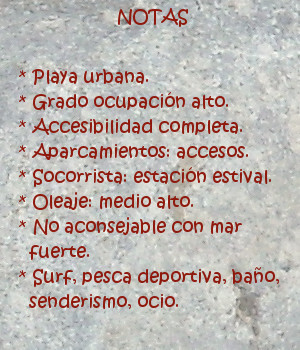
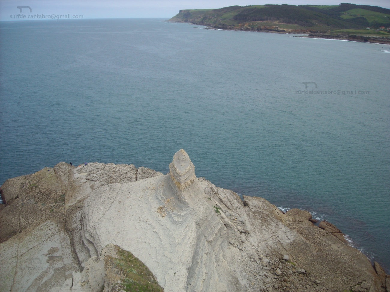
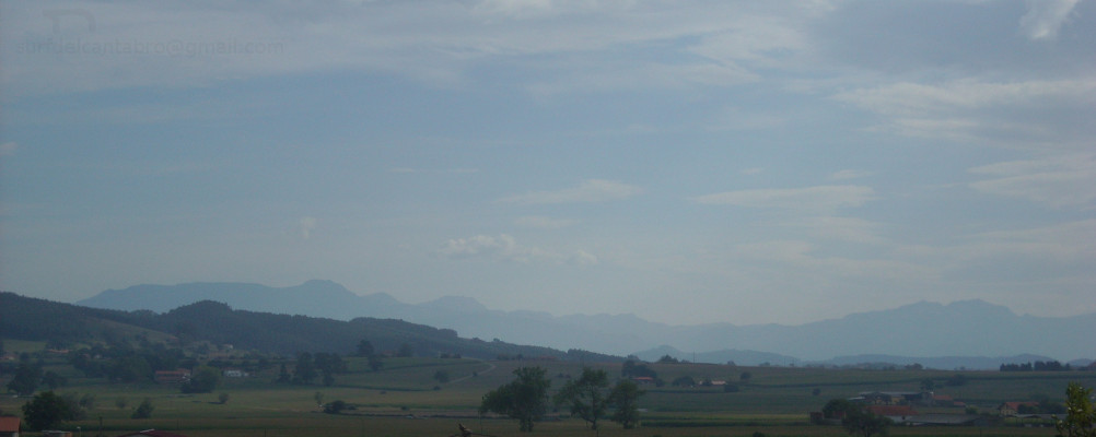
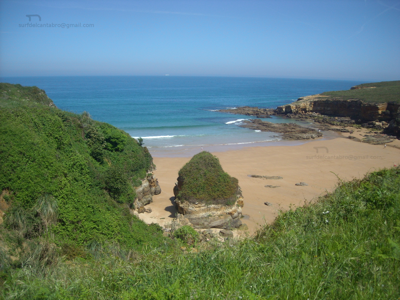
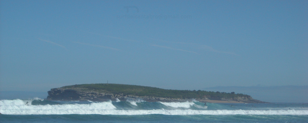
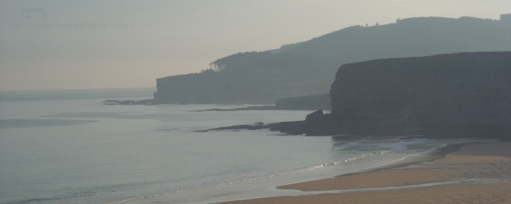
La Maruca, lugar

Icono Español. Icon Spanish. la maruca lugar La Maruca es una ensenada natural ubicada en la desembocadura del Arroyo de la Tejona o Ría de San Pedro del Mar. Emplazada en la costa norte de la ciudad de Santander en el barrio de Monte, su forma de «L» invertida alberga un pequeño puerto pesquero, la playa de la Maruca y los acantilados que acompañan al Mar Cantábrico hasta su encuentro con la ensenada.

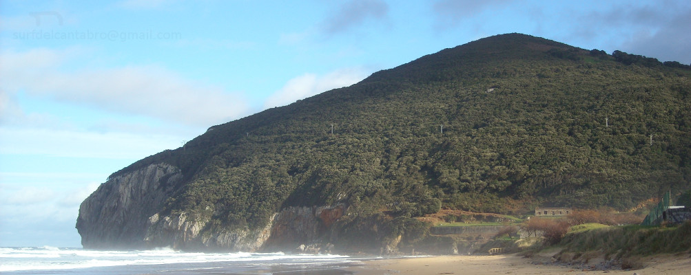
Dispone de un paseo marítimo que se ocupa toda su extensión, dando acceso a una zona amplia de aparcamientos, restaurantes, y al Centro de Interpretación del Litoral; museo dedicado al mar. Antigua zona de pescadores, en el centro de la ensenada se erige la estatua de un pescador, homenaje a la gente del mar que puebla el barrio de Monte.

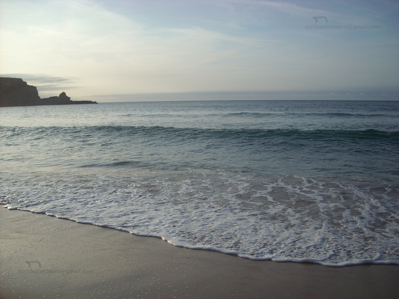
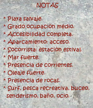
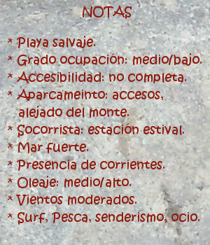
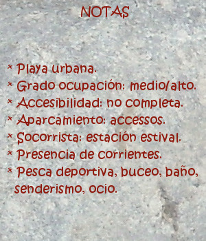
La playa de la Maruca es de arena fina, abundante en rocas, de irregular y original forma, es apta para el baño y el recreo. La pesca deportiva y el submarinismo encuentran en esta zona condiciones naturales ideales. El fondo rocoso y arenoso,junto con la proximidad del mar abierto, contribuyen al enriquecimiento de los fondos marinos y la abundancia de especies de peces, a lo que se suma la presencia ocasional de focas y delfines.
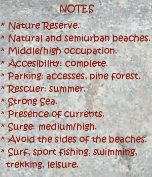
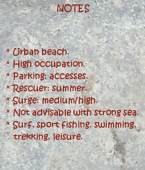
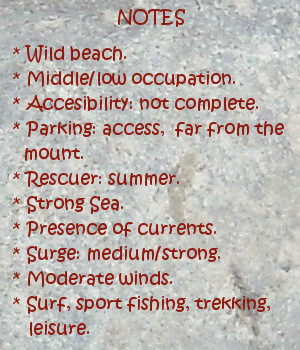
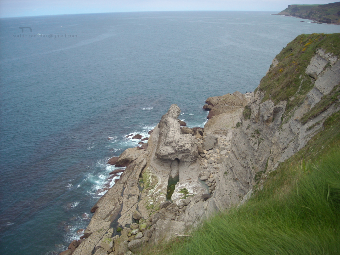
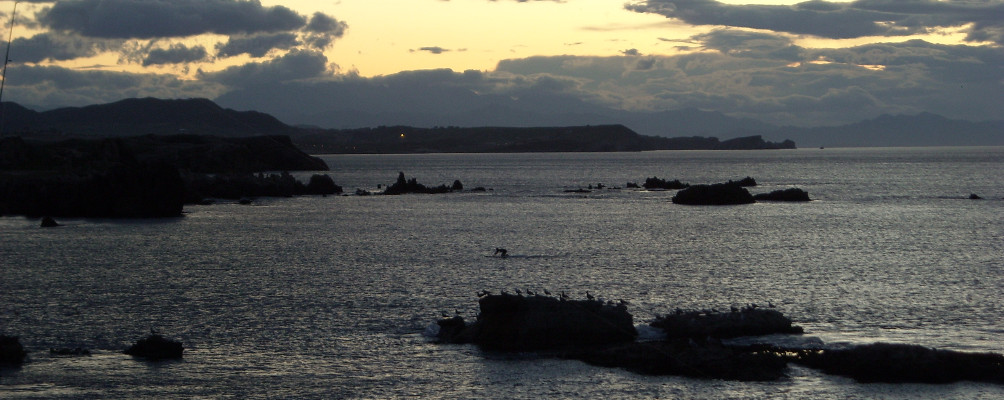
comic, mountain
La Maruca lugar, notas

La Maruca, place

Icono Inglés. Icon English La Maruca is a natural inlet located in the mouth of the Creek of La Tejona or Stuary of San Pedro del Mar. Located on the north coast of the city of Santander, in Monte’s neighborhood, its form of «L» reversed shelters an small fishing port, the beach of the Maruca and the cliffs that accompany the Cantabrian Sea up to its meeting with the inlet.

It has a promenade that extends across all its area, leading to a wide zone of parkings, restaurants, and to the Center of Interpretation of the Littoral; museum dedicated to the sea. Fishermen’s ancient zone, in the center of the inlet the statue of a fisherman is raised, honoring to the people of the sea who populates Monte’s neighborhood.

The beach of the Maruca is of thin sand, abundant in rocks, of irregular and original form, it is suitable for swimming and the entertainment. The sports fishing and the scuba diving find in this zone a natural ideal conditions. The rocky and sandy bottom, together with the proximity of the open sea, contribute to the enrichment of the sea beds and the abundance of species of fish, plus the occasional presence of seals and dolphins.

comic, mountain
La Maruca place, notes

Share

Parque Natural Dunas de Liencres, lugar

Icono Español. Icon Spanish. El Parque natural de las Dunas de Liencres se ubica en la localidad costera cántabra de Liencres, perteneciente al municipio de Piélagos. Tiene una extensión de 256,81 hectáreas localizadas a lo largo de la desembocadura del río Pas; conocida como Ría de Mogro. Donde las corrientes son fuertes y constantes, debido al efecto de las mareas,imposibilitando la práctica del surf.

El parque se extiende desde la Ría de Mogro hacia el este. incluyendo formaciones dunares que se desplazan por efecto del viento, un gran bosque de pino Marítimo que asienta las dunas y da forma al parque, y dos playas que miran a mar abierta: Valdearenas y Canallave.

La playa de Valdearenas es la de mayor extensión, con una longitud de 2800 metros y 40 metros de anchura media. Alberga varias zonas con diferentes picos de olas que se anexan unos a otros, plasmando la naturaleza salvaje y fuerte del Mar Cántabrico a través en cada onda que se navegue. Todas las zonas presentan fuertes corrientes, aumentando en los laterales de la playa.

La playa de Canallave, la menor de las dos, tiene una longitud de 220 metros y una anchura media de 50 metros. De forma irregular, compuesta de arena fina y sembrada de rocas, extiende su trazado hacia el este. Cuenta con dos olas definidas. Naciendo a 100 metros de la orilla, elevan su tamaño sobre los dos metros, para avanzar después y abrir el trazado a ambos lados. La zona más alejada, situada en frente de los acantilados de la Costa Quebrada, es conocida como El Madero.

comic, mountain
Liencres, notas

Liencres Dunes Nature Reserve, place

Icono Inglés. Icon English. The Liencres Dunes Nature Reserve is located in coastal Cantabrian locality of Liencres, belonging to the municipality of Piélagos. It has an extension of 256,81 hectares placed along the mouth of Pas river; known as Stuary of Mogro. Where the currents are strong and constant, due to the effect of the tides, which not allow to practice surf.

The park spreads from the stuary of Mogro eastward. Including dune formations that move for effect of the wind, a great forest of Maritime pine that hold the dunes and it gives form to the park, and two beaches that meet at opened sea: Valdearenas and Canallave.

The beach of Valdearenas is that of major extension, with a length of 2800 meters and 40 meters of average width. It shelters several zones with different beaks of waves that each one is next to the others, comunicating the wild and strong nature of the Cantabrian Sea through every wave that is navigated. All the zones have strong currents, which increase in the wings of the beach.

The beach of Canallave, the minor of the two beaches, has a length of 220 meters and an average width of 50 meters. Its irregular form consisted of thin sand and filled with rocks, it extends its tracing eastward. It possesses two definite waves. Them are born to 100 meters of the shore, to raise its size over two meters, to advance later and open the tracing for both sides. The most remote zone placed opposite the cliffs of the Quebrada Coast, is known as El Madero.

comic, mountain
Liencres, notes

Share

El Sardinero, playa

Icono Español. Icon Spanish. Sardinero playa El Sardinero, ubicado en la ciudad de Santander, es un área grande que se extiende desde la Península de la Magdalena hasta la zona de Mataleñas; próxima al Faro de Cabo Mayor. Sus playas se alojan en un arenal cuya superficie supera las 10 hectáreas. Con una longitud de 1500 metros y una anchura media de 80 metros, el banco de arena queda dividido en dos partes por los Jardines de Píquio. Aparecen así dos playas conocidas como: la Primera playa del Sardinero y la Segunda playa del Sardinero y cuatro zonas diferenciadas, que a la anteriores se unen La Concha y El Muro.

Dentro de esta ensenada que precede a la Bahía de Santander el surf es una de las actividades más importantes. Cuenta con varias zonas y olas diferentes. Los días de mar fuerte las olas entuban y cierran en bloque, no siendo aconsejable su práctica.

Es el Sardinero una playa que convive directamente con el Mar Cántabrico, y sufre los efectos de los temporales que en invierno azotan Cantabria. Por este motivo, hace unos año se reconstruyó el paseo de la parte final de la segunda playa, ampliando y reforzando el muro que allí había. Esta nueva zona espera a las olas que arriban a ella, agolpando y comprimiendo su energía para regenerar las ondas con superficie lisa y medio recorrido. Ola tras ola, ola con ola; forman un circuito que se conoce como El Muro.

comic, mountain
El Sardinero playa, notas

Sardinero, beach

Icono Inglés. Icon English. Sardinero beach El Sardinero, that is located in the city of Santander, it is an extensively area that spreads from the Peninsula of La Magdalena up to Mataleñas’s zone; next the Lighthouse of Cabo Major. Its beaches lodge at a sandbank which surface overcomes 10 hectares. With a length of 1500 meters and width of 80 meters, the bank of sand remains divided in two parts by the Gardens of Píquio. So two beaches appear, known like: the First beach of the Sardinero and the Second beach of the Sardinero and four differentiated zones: La Concha, El Muro and the previous beaches.

Inside this inlet that precedes the Bay of Santander the surf it is one of the most important activities. It possesses several zones and different waves. The days with strong sea the waves create tubes that finish in block, not being advisable its practice.

It is the Sardinero a beach that coexists directly with the Cantabrian Sea, and suffers the effects of the temporary ones that in winter flog Cantabria. For this motive, a few years ago , the promenade of the final part of the second beach was reconstructed, extending and reinforcing the wall that there existed. This new zone receives the arrival of the waves, pushing and compressing its energy to regenerate the waves with smooth surface and medium distance. Wave after wave, wave with wave; them form a circuit that is known as El Muro.

comic, mountain
El Sardinero, notes

Share

Galizano, playa

Icono Español. Icon Spanish. Galizano beach Galizano es una localidad cántabra, perteneciente al municipio de Ribamontán al Mar. Situado junto a la Ría la Canal, desembocadura del río Herrera, esta configuración ha formado la playa de Galizano, también llamada de San Miguel o de la Canal.

Los acantilados que presenta la costa de Galizano tienen vegetación abundante y fondo marino rocoso. El fuerte oleaje que llega a la zona convierte la practica del surf en una actividad sólo recomendada para surfers experimentados. La longitud de la playa es de 150 metros. Su irregular y original forma, dibujada por la ría que traza el camino del arenal entre los acantilados que la rodean hasta alcanzar el mar, tiene una anchura media de 100 metros, que en bajamar permite el acceso a pequeñas calas.

Es su entorno salvaje propicio para realizar rutas de senderismo que se extienden hasta Langre; hacia el oeste y Ajo; hacia el este. El trayecto transcurrirá repleto de estímulos. Acantilados verticales y estratificados, golpeados en su base por el mar, hablan de la historia del tiempo escrita su piel. Montes y montañas, cuevas, arrecifes rocosos,… hacen de la pesca recreativa y el buceo actividades completas, regalando en cada ocasión una nueva experiencia.

comic, mountain
Galizano playa, notas

Galizano, beach

Icono Inglés. Icon English. Galizano playa Galizano is a Cantabrian locality, belonging to the municipality of Ribamontán al Mar. Placed next to the rivermouth La Canal, which is the end of the river Herrera, this configuration has formed Galizano’s beach, also call San Miguel or La Canal.

The cliffs that Galizano’s coast presents have abundant vegetation and rocky sea bottom. The strong surge that comes to the zone turns the practice of the surf into an activity only recommended for surfers experienced. The length of the beach is 150 meters. Its irregular and original form, drawn by the rivermouth that plans the way of the sandbank between the cliffs that surround it up to reaching the sea, it has an average width of 100 meters, which in low tide allows the access to small coves.

It is its wild environment, propitious to realize trekking routes that spread up to Langre; towards the west and Ajo; eastward. The journey will pass replete with stimuli. Cliffs vertical and stratified , struck in its base for the sea that speak about the history of the time written in its skin. Mounts and mountains, caves, rocky reefs… that do of the recreative fishing and the scuba-diving; complete activities, giving in every occasion a new experience.

comic, mountain
Galizano beach, notes

Share

El Brusco , lugar

Icono Español. Icon Spanish. El Brusco place EL Brusco es un monte emplazado en el municipio de Noja,en la costa oriental de Cantabria. Situado al final de la playa de Trengandín, tiene una altura de 99 metros y una superficie aproximada de 15 hectáreas. Su arcaica estructura se muestra y esconde al compás de las mareas. Aparecen los cimientos con la bajamar. Intuidos sobre un mosaico compuesto por miles de rocas. Afiladas, troceadas, por el mar tocadas.

Este pequeño monte constituye un emplazamiento singular. Incluido en la formación montañosa de los Montes de Mijedo, es la única zona del macizo que sobresale en la línea de costa y cuya base se asienta en el mar. La ubicación y el medio que lo rodean, han moldeado su perímetro y dibujado su forma, con el paso del tiempo; convirtiendo al monte en frontera natural entre las playas de Trengandín y Berria y los municipios de Noja y Santoña.

A los pies del Brusco comienza una senda que conduce a lo alto del monte, para descender de nuevo hacia el otro lado hasta encontrar la playa de Berria. Transcurre el sendero inundado de vegetación. Robles y hayas predominan en la zona, acompañados de sotobosque. Este paso natural, convertido en senda, tiene una anchura de apenas medio metro. Tras los primeros pasos, las distancias a los puntos contiguos se agrandan, haciendo recordar la civilización como un ruido distante. Acto seguido aparecerá una natural y sencilla melodía, siempre nueva y no obstante; familiar. La brisa marina recorre todo la zona, moviendo la vegetación a su libre albedrío. Desde la cima podremos contemplar Noja y sus extensas playas a la izquierda, pasando por Berria a la derecha, El monte el Buciero y Santoña; después y entre sus marismas a modo de vivo paisaje.

Los días con buenas condiciones, las olas alcanzan los dos metros de altura. Lejos del monte, donde las corrientes son fuertes y forman remolinos, aparecen varios tipos de ola. Abriendo a ambos lados, su recorrido; a través de una tersa pared de agua, es casi constante y prolongado. Favorece las maniobras y salidas limpias .

comic, mountain
El Brusco, notas

El Brusco, place

Icono Inglés. Icon English. El Brusco place El Brusco is a mount located in the municipality of Noja, in the oriental coast of Cantabria. Placed at the end of Trengandín’s beach, it has a height of 99 meters and an approximate surface of 15 hectares. Its archaic structure appears and hides to the compass of the tides. The foundations appear with the low tide. Intuitively on a mosaic composed by thousands of rocks. Sharpened, cut into pieces, as the sea touched them , have touched and will be touched.

This small mount constitutes a singular place. Included in the mountainous formation of Mijedo’s Mounts, it is the only zone of the mountain massif that stands out in the line of coast and has its base in the sea. The location and the environment that surround it, have molded its perimeter and drawn its form with the passage of time; turning to the mountain in a natural border between the beaches of Trengandín and Berria and the municipalities of Noja and Santoña.

At the foot of El Brusco begins a path that comes up to the top, to descend again towards another side up to finding Berria’s beach. The path is flooded with vegetation. Oaks and beeches prevail in the zone, accompanied of undergrowth. This passageway turned into path, has a width of scarcely half a meter. After the first steps, the distances to the contiguous points are enlarged, making remember the civilization as a distant noise. Forthwith a natural and simple melody will appear, always newly and nevertheless; familiar. The marine breeze crosses the zone, moving the vegetation to its free will. From the top we will be able to contemplate Noja and its extensive beaches to the left, shifting for Berria to the right, The mount El Buciero and Santoña; behind and between its marshes like an alive landscape.

The days with good conditions, the waves reach two meters of height. Far from the mount, where the currents are strong and form whirlpools, several types of wave appear. Opening to both sides, its tour; across a smooth wall of water, it is almost constant and long. It favors the maneuvers and clear exits.

comic, mountain
El Brusco, notes

Share