Playa Arenal de Sonabia, localización

Icono. Icon. Arenal de Sonabia La playa Arenal de Sonabia es un cala situada en la localidad de Sonabia, perteneciente al municipio de Liendo. El viaje transcurre por autovía y finaliza en la carretera nacional que atraviesa Oriñón, hasta llegar a Sonabia y su playa. Veremos el acceso al arenal antes de finalizar la ruta. Se muestran a continuación como puntos de partida Oviedo, Palencia, Santander y Bilbao.

Beach Sandbank of Sonabia, localization

Icono. Icon. Sonabia, sandbank The beach, Sandbank of Sonabia, is a cove placed in the locality of Sonabia, belonging to the municipality of Liendo. The travel passes for motorway and finishes in the national road that crosses Oriñón, up to coming to Sonabia and its beach.We will see the access to the beach before finishing the route. Shown below as starting points Oviedo, Palencia, Santander and Bilbao.

Icono español-inglés. Icon Spanish-English. Arenal de Sonabia, sandbank Localización/Localization

Oviedo, Arenal de Sonabia : LocalizationPalencia, Arenal de Sonabia : localizationBilbao, Arenal de Sonabia : localizationSantander, Arenal de Sonabia : localization

Icon close Sponsor

Share

Playa de Luaña, Acceso

Icono Español. Icon Sapnish. Playa de Luaña La Playa de Luaña está situada en la localidad de Cóbreces. Este pueblo se ubica en la costa occidental de Cantabria, entre las villas de Comillas y Santillana del Mar. Cuenta con dos accesos, oeste y este. Un pequeño aparcamiento es el último paso antes de llegar a la arena.

Luaña Beach, access

Icono Inglés. Icon English. Playa de Luaña The Beach of Luaña is placed in the locality of Cóbreces. This town is located on the western coast of Cantabria, between the villas of Comillas and Santillana del Mar. It possesses two accesses, west and east. An small parking is the last step up to the sand.

Icono español-inglés. Icon Spanish-English. Playa de Luaña Acceso/Access

Access Playa de Luaña

Share

Playa de Luaña, localización

Icono. Icon La playa de Luaña está situada en la localidad de Cóbreces, perteneciente al municipio de Alfoz de Lloredo. Es posible llegar a esta playa desde el oeste, el este y el sur. El viaje transcurre por autovía y finaliza a través de varias carreteras nacionales. Veremos el acceso a la playa antes de finalizar la ruta. Se muestran a continuación como puntos de partida Oviedo, Palencia, Santander y Bilbao.

Beach of Luaña, localization

Icono. Icon The beach of Luaña is placed in the locality of Cóbreces, belonging to the municipality of Alfoz de Lloredo. You can arrive to this beach from the west, the east and the south. The travel passes for motorway and finishes across several national roads.We will see the access to the beach before finishing the route. Shown below as starting points Oviedo, Palencia, Santander and Bilbao.

Icono español-inglés. Icon Spanish-English Localización/Localization

Oviedo, playa de Luaña: LocalizationPalencia, playa de Luaña: localizationBilbao, playa de Luaña :localizationSantander, playa de Luaña: localization

Icon close Sponsor

Share

Playa de Trengandín, acceso

Icono Español. Icon Spanish. Playa de Trengandín La playa de Trengandín está situada en la Villa de Noja. Ubicada entre Santoña e Isla, en la costa oriental de Cantabria. Con una extensión mayor de seis kilómetros, cuenta con numerosas zonas de aparcamiento que dan acceso directo a la playa. Presenta una agrupación de rocas en su parte central, siendo peligrosa la practica del surf en la zona.

Tregandín beach, access

Icono Inglés. Icon English. Playa de Trengandín Trengandín beach is placed in the Villa of Noja. Located between Santoña and Isla, in the oriental coast of Cantabria. With a major extension of over six kilometres, it has on numerous zones of parking that give direct access to the beach. There are a group of rocks in its central part, being dangerous the practice of the surf in the zone.

Icono español-inglés. Icon Spanish-English. Playa de Trengandín Acceso/Access

Access: playa de Trengandín

Icon close Sponsor

Share

Playa de Trengandín, Localización

Icono Español. Icon Spanish La Playa de Trengandín está situada en la Villa de Noja, en la costa oriental de Cantabria. Tiene una extensión superior a los seis kilómetros. En su parte central, su fondo arenoso se mezcla con abundantes rocas puntiagudas y afiladas, que apenas cubre la pleamar. En esta zona se puede practicar el baño, la pesca y el submarinismo, siendo peligrosa la práctica del surf. Se puede llegar a esta playa desde Oviedo, Palencia, Santander o Bilbao, como ciudades adyacentes. Todos los trayectos finalizan por la carretera nacional CA-147.

Beach of Trengandín, localization

Icono Inglés. Icon English Beach of Trengandín is placed in the Villa of Noja, on the oriental coast of Cantabria. It has an lenght over six kilometres. In its central part, its sandy bottom is mixed by abundant sharp-pointed and sharp rocks which the high tide scarcely covers. In this zone it is possible to practise the bath, the fishing and the scuba diving, being dangerous the practice of the surf. It is possible to come to this beach from Oviedo, Palencia, Santander or Bilbao, as adjacent cities. All the routes finish for the national road CA-147.

Icono Español-Inglés. Icon Spanish-English Localización/Localization

Oviedo,Playa de Trengandín: localizationPalencia, Playa de Trengandín: localizationBilbao, Playa de Tregandín: localizationSantander, Playa de Trengandín: localization

Icon close Sponsor

Share

Playa de Arenilla, acceso

Icono Español. Icon Spanish La Playa de Arenilla está en Galizano. Situada entre la playas de Langre y Galizano, es una pequeña cala con un acceso escarpado. Tiene una ancha y pedregosa entrada utilizada a modo de aparcamiento. El fondo de roca, los acantilados y las fuertes corrientes; presentes en la zona la convierten en un lugar peligroso. Las rutas que llegan e la zona provienen del oeste ( Oviedo, Palencia, Santander ) y del este ( Bilbao ) deben atravesar la localidad de Galizano, cruzar el Barrio de Pedrosa y dirigirse hacia la costa en el primer cruce que aparece. Después la misma carretera nos conduce a la entrada de la Playa de Arenilla.

Beach of Arenilla, access

Icono. Icon The Beach of Arenilla is located in Galizano. Placed between the beaches of Langre and Galizano, it is a small cove with a craggy access. It has a broad and stony entry used like parking. The rocky bottom, the cliffs and the strong currents; presents in the zone turn her into a dangerous place. The routes that come from the west (Oviedo, Palencia, Santander) and from the east (Bilbao) must cross Galizano’s locality, through the Neighborhood of Pedrosa, to go towards the coast in the first crossing that appears. Later, the same road, leads us at the entrance of the Beach of Arenilla.

Icono Español-Inglés. Icon Spanish-English Acceso/Access

Access: Playa de Arenilla, acceso

Icon close Sponsor

Icon close Sponsor

Share

Playa de Arenilla, localización

Icono Español. Icon Spanish La Playa de Arenilla se encuentra en la localidad de Galizano, que pertenece al municipio de Ribamontán al Mar. Su localización no aparece en las guías oficiales, además la abundancia de caminos que dan acceso a las fincas de siembra de la zona, complican la situación de este punto. La playa es una pequeña cala de difícil acceso y rodeada por acantilados sobre mar abierta. Apta para el baño con precaución y la practica del surf, pues tiene fuertes corrientes y puede ser peligrosa. El viaje se hace por autovía y finaliza por carretera nacional y comarcal. Una vez situados en Galizano iremos hacia el Barrio de Pedrosa. Dejado atrás el barrio,tomamos el primer desvío a la derecha. Seguimos la carretera recta, sin coger ningún desvío más. Un kilometro después, veremos la cala, con un pequeño y pedregoso aparcamiento a su entrada. A continuación se muestra como puntos de partida: Oviedo, Palencia, Santander y Bilbao. Cualquier otro origen atraviesa uno de estos puntos.

Beach of Arenilla, Localization

Icono. Icon The Beach of Arenilla is placed in the locality of Galizano, that belongs to the municipality of Ribamontan al Mar. Its location does not appear in the official guides. In addition the abundance of roads that lead to the farm lands of the zone, it complicate the situation of this point. The beach is a small cove of difficult access and surrounded by cliffs and rocks on opened sea. Suitable for the bath with precaution and the practice of the surf, due to it has current forts and can be dangerous. The trip is done by highway and finishes by road nationally and regionally. Once placed in Galizano iremos towards the Neighborhood of Pedrosa. Leaving behind the neighborhood, we take the first detour to the right. We follow the straight road, without taking any other detour. A kilometre later, we will see the cove, with a small and stony parking at its entry. Shown below as starting points: Oviedo, Palencia, Santander and Bilbao. Any other origin crosses some of these points.

Icono Español-Inglés. Icon Spanish-English Localización/Localization

Oviedo, Playa de Arenilla:  LocalizationPalencia, Playa de Arenilla: localizationBilbao, Playa de Arenilla: localizationSantander, Playa de Arenilla: localization

Icon close Sponsor

Share

Playa de Tagle, acceso

Icono Español. Icon Spanish. Playa de tagle, acceso La playa de Tagle está situada en la localidad de Tagle, que se ubica dentro del municipio de Suances, en la costa occidental de Cantabria. Atravesando el pueblo se llega a la playa, el acceso está bien señalizado. Cuenta con una amplia zona de aparcamiento que finaliza en la entrada del arenal.

Beach of Tagle, access

Icono Inglés. Icon English. Playa de tagle, access The beach of Tagle is placed in the locality of Tagle, which is located inside Suances’s municipality, in the western coast of Cantabria. Through the village you come to the beach, the access is well put up signs. It possesses a wide zone of parking that finishes in the entry of the sandbank.

Icono Español-Inglés. Icon Spanish-English. Playa de tagle, acceso/access Acceso/Access

Tagle Beach, access

Icon close Sponsor

Share

Playa de Tagle, localización

Icono Español. Icon Spanish La playa de Tagle está situada en la localidad de Tagle, perteneciente al municipio de Suances. Es una playa acantilada en sus laterales, con fondo rocoso y fuertes corrientes. El viaje transcurre por autovía y finaliza a través de varias carreteras nacionales. La salida de la autovía está bien indicada, así como la llegada al pueblo y el acceso desde allí a la playa. Se muestran a continuación como puntos de partida Oviedo, Palencia, Santander y Bilbao.

Beach of Tagle, localization

Icono. Icon The beach of Tagle is placed in the locality of Tagle, belonging to the municipality of Suances. This beach has cliffs in its wings, rocky bottom and current forts. The travel passes for motorway and finishes across several national roads. The exit of the highway is well indicated, as well as the arrival to the village and the access from there to the beach. Shown below as starting points Oviedo, Palencia, Santander and Bilbao.

Icono Español-Inglés. Icon Spanish-English Localización/Localization

Oviedo, playa de Tagle: localizationPalencia, playa de  Tagle: localizationBilbao, playa de  Tagle: localizationSantander, playa de Tagle: localization

Icon close Sponsor

Share

Langre, descubriendo las olas. Camino

icono bandera España 
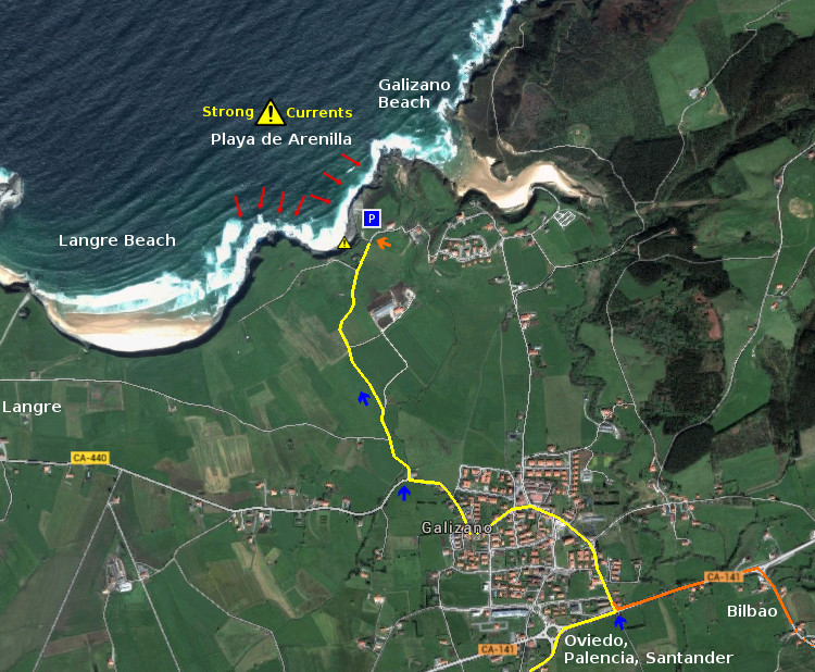
El atardecer llegó de improvisto. Los viajes y espectáculos vividos habían hecho olvidar la mundana concepción del tiempo. La playa aún conservaba luz suficiente para continuar surfeando. Sobre el acantilado de Langre, una línea difuminada de color anaranjado iba ocupando parte del cielo.

Alejado de las rocas permanecí un tiempo prolongado. Con el mar ondulante de fondo y el agua liberada de gente, apareció un viento que pulía la superficie de las olas. Aquella brisa alentaba el movimiento, rodeando las figuras que encontraba a su paso. Un estruendo sonó distante. Contra La Punta de Langre, chocaban las olas que llegaban erguidas en el momento del impacto. Sobre las rocas cruzaba el agua que salía despedida, cubriendo la zona por un instante. La pleamar dotó al oleaje con más energía. Otras olas avanzaban hacia la playa, manteniendo una serie armónica de menor tamaño y haciendolas hábiles. La mejores condiciones de estas últimas, estimulaban la imaginación en busca de una gran ola.

Avanzando hacia el interior y situado a cien metros del centro, veía llegar las series. Caminando a la izquierda ,sobre ellas, un rizo que terminaba limpio. Descolgando partes de la cresta, continuaba su trazado. Buscando una posición mejor, llegué al extremo central. Poco tiempo después arribó una ola mediana. El golpe con la tabla me ancló a su cresta. Corrí unos metros sobre ella. Descendí a la base para seguir el camino. Con un embudo de agua detrás de mí y gotas salpicando sobre el trayecto de la tabla, fijé la atención hacia adelante. Tras un par de giros, sincronicé mi marcha con la del mar. La onda fue rebajando su tamaño hasta rodar sobre la superficie. Terminé el viaje con un feliz y tranquilo salto. Suspendido en el agua, sentí atravesar una ligera brisa por mi contorno.

Apurando la tarde hasta el final, continué en el agua con otros colegas. Otra chica se subió a un ola. Realizando un aéreo sobre la cima, aterrizó con suavidad en su base. Continuó su marcha ondulando su trazado. Al encontrarse de nuevo con la cresta repitió la misma maniobra. Con el paso de la onda desapareció su figura. Minutos después estaba en la arena recogiendo su equipo, para llegar al aparcamiento. El final de la sesión se iba acercando.

Esperé un cuarto de hora, descansando y disfrutando del mar. Otro surfer alcanzó una buena ola. Corriendo ya en su base, aquella comenzó a cubrirlo. Su silueta se veía sobre, y dentro del agua. Adquiriendo velocidad dejó atrás el agua que rompía. El resto de nosotros mirábamos con atención. Durante decenas de metros siguió con la maniobra hasta salir del tubo para acabar remando hacia la orilla. La ola continuó y lo alcanzó la espuma.

Pensando en finalizar, un sonido me hizo girar la mirada a mar abierto. Una buena serie llegaba. Pasaron las primeras olas, preparé la tabla para la tercera. Cuando llegó, tenía dos metros de altura. Flotando sobre la cresta, incliné mi cuerpo hacia adelante. Bajando a la base, ví como la ola comenzó a entubar. Giré a la izquierda buscando la salida. Corriendo debajo de la cobertura que se formó, alcancé una nueva abertura. Surfeé hacia la cima. De nuevo en la base, la ola volvió a entubar. Antes de que completara el cierre, me deslicé más allá de ese punto. Curvando la trayectoria de nuevo a su tope, conseguí esquivar la rotura ya producida. Continué el viaje pegado a la cima, siguiendo el camino hasta encontrar un claro que se abrió antes del cierre contrario. Con un gesto, subí la ola y pasé al otro lado. La onda se desplomó, alejando su estela hacia la orilla.

Lagre, discovering the waves. Way

EnglishThe late afternoon came suddenly. The trips and spectacles that were lived, had exiled the mundane conception of time . The beach still was preserving sufficient light to continue surfing. Over the cliffs of Langre, a blurred line of orange color was occupying part of the sky.

Removed from the rocks, I remained a long time. With the undulating sea of bottom and the water liberated of people, a wind appeared that drew the surface of the waves. That breeze was encouraging the movement, surrounding the figures that he was finding to its step. An uproar sounded distantly. Against The Tip of Langre, were shocking the waves that were coming raised in the moment of the impact. Over the rocks, the water was crossing through the blow, covering the zone for an instant. The tide provided to the surge with more energy. Other waves were advancing towards the beach, with a harmonic series of minor size and making them usefull. The better conditions, of the above mentioned, were stimulating the imagination in search of a great wave.

Advancing inside and as I placed to hundred meters of the center, I saw the series that came. Walking to the left side, of them, a curl that was ending cleanly. Parts of the crest were broken, but the wave was continuing its tracing. Looking for a better position, I came to the central end. A little time later, a medium wave arrived. It blow with the board, anchored me to its top. I ran a few meters on it. I descended to the base to follow the way. With a water funnel behind me, and drops that were splashing on the path of the board, I fixed the attention ahead. After a couple of drafts, I synchronized my march with that of the sea. The wave was reducing its size until it rolled on the surface. I finished the trip with a happy and calm jump. Suspended in the water, I felt a light breeze that crossed for my contour.

Playing through afternoon until the end, I was in the water with other colleagues. Another girl was raised to an wave. Doing an air wave on the top, she landed with smoothness in the base. She continued his march waving his tracing. The re-meeting with the top produced the same maneuver. With the steps of the wave, her figure dissapeared. Minutes later, she was, in the sand, carrying on her equipment, to come to the parking. The end of the session was approaching.

I waited for a quarter of hour, resting and enjoying the sea. Another surfer reached a good wave. Running already in its base, that began to cover it. His silhouette was seen on, and inside the water. The speed allowed him to left behind the water that was breaking. The rest of us were looking with attention. During dozens of meters it continued with the maneuver up to going out of the pipe to finish towards the shore. The wave continued and the foam reached him.

Thinking of finish, a sound made me turn the look to open sea. A good series was coming. The first waves happened, I prepared the board for the third one. When it came, it had two meters of height. Floating on the top, I inclined the body ahead. Going down to the base, I saw as the wave began to coil. I turned to the left side looking for the exit. Running under the coverage that was formed, I reached a new opening. I sailed towards the crest. Again in the base, the wave returned to coil. Before the closing would be completed, I slipped beyond that point. Towards the path again of its ceiling, I managed to avoid the already produced break. I tried the trip stuck to the top, following the way until a safe zone was opened before the opposite closing. With a gesture, I raised the wave and went to other side. The wave collapsed, painting its stela towards the shore.
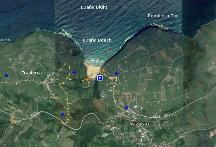
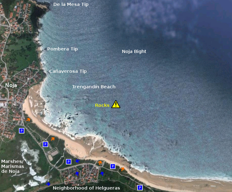
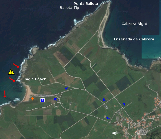
Icon close Sponsor

Share