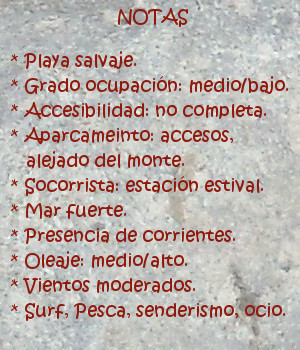
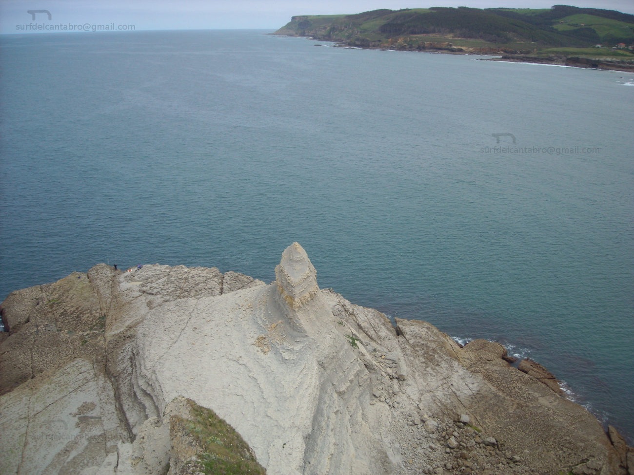
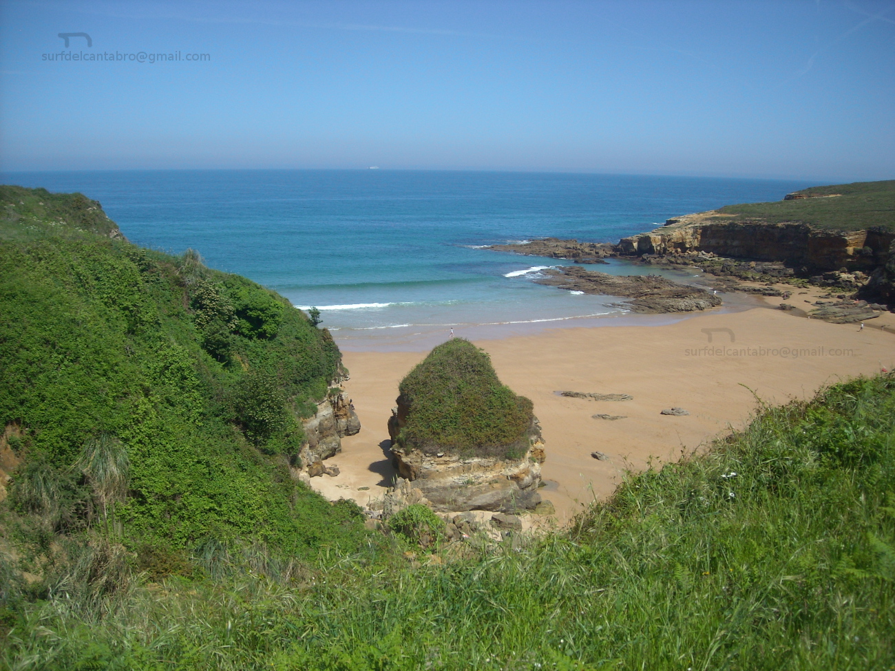
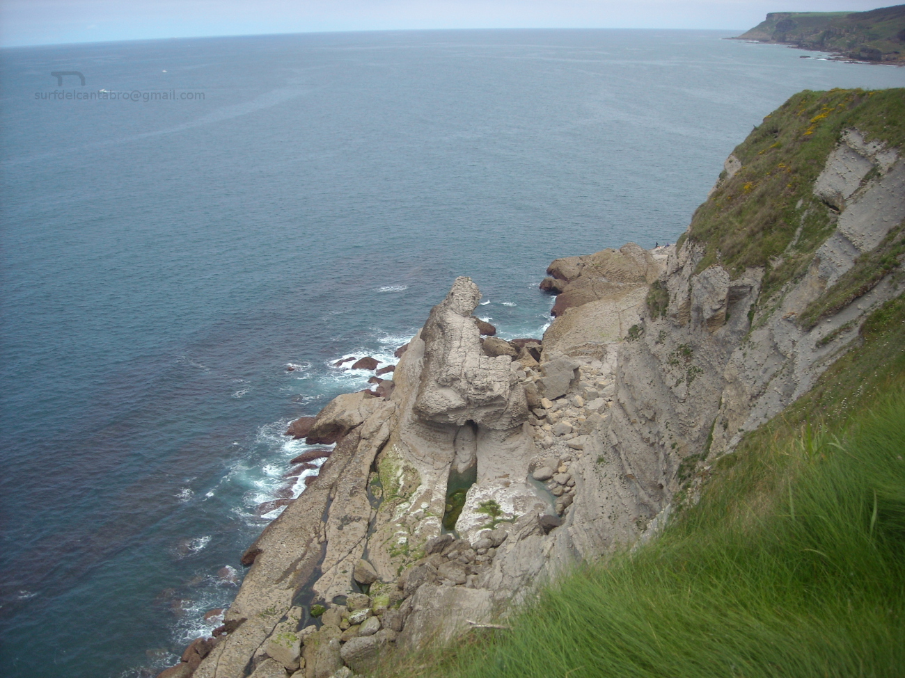
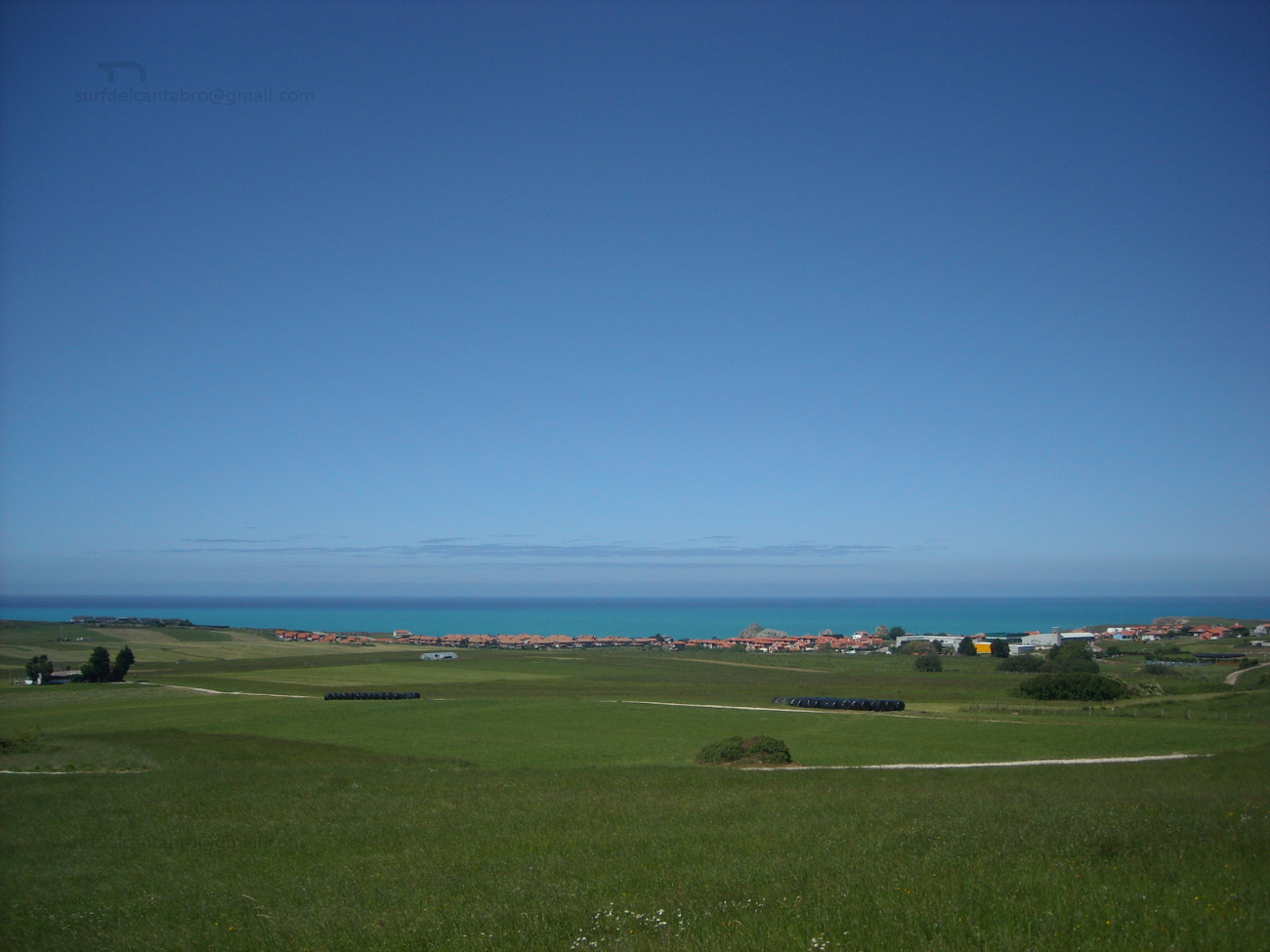
El Sardinero, playa

Icono Español. Icon Spanish. Sardinero playa El Sardinero, ubicado en la ciudad de Santander, es un área grande que se extiende desde la Península de la Magdalena hasta la zona de Mataleñas; próxima al Faro de Cabo Mayor. Sus playas se alojan en un arenal cuya superficie supera las 10 hectáreas. Con una longitud de 1500 metros y una anchura media de 80 metros, el banco de arena queda dividido en dos partes por los Jardines de Píquio. Aparecen así dos playas conocidas como: la Primera playa del Sardinero y la Segunda playa del Sardinero y cuatro zonas diferenciadas, que a la anteriores se unen La Concha y El Muro.

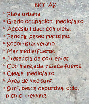
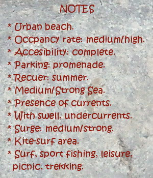
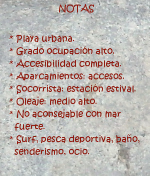
Dentro de esta ensenada que precede a la Bahía de Santander el surf es una de las actividades más importantes. Cuenta con varias zonas y olas diferentes. Los días de mar fuerte las olas entuban y cierran en bloque, no siendo aconsejable su práctica.

Es el Sardinero una playa que convive directamente con el Mar Cántabrico, y sufre los efectos de los temporales que en invierno azotan Cantabria. Por este motivo, hace unos año se reconstruyó el paseo de la parte final de la segunda playa, ampliando y reforzando el muro que allí había. Esta nueva zona espera a las olas que arriban a ella, agolpando y comprimiendo su energía para regenerar las ondas con superficie lisa y medio recorrido. Ola tras ola, ola con ola; forman un circuito que se conoce como El Muro.
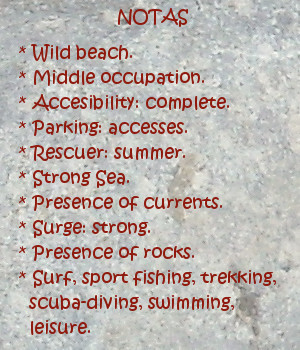
comic, mountain
El Sardinero playa, notas

Sardinero, beach

Icono Inglés. Icon English. Sardinero beach El Sardinero, that is located in the city of Santander, it is an extensively area that spreads from the Peninsula of La Magdalena up to Mataleñas’s zone; next the Lighthouse of Cabo Major. Its beaches lodge at a sandbank which surface overcomes 10 hectares. With a length of 1500 meters and width of 80 meters, the bank of sand remains divided in two parts by the Gardens of Píquio. So two beaches appear, known like: the First beach of the Sardinero and the Second beach of the Sardinero and four differentiated zones: La Concha, El Muro and the previous beaches.

Inside this inlet that precedes the Bay of Santander the surf it is one of the most important activities. It possesses several zones and different waves. The days with strong sea the waves create tubes that finish in block, not being advisable its practice.

It is the Sardinero a beach that coexists directly with the Cantabrian Sea, and suffers the effects of the temporary ones that in winter flog Cantabria. For this motive, a few years ago , the promenade of the final part of the second beach was reconstructed, extending and reinforcing the wall that there existed. This new zone receives the arrival of the waves, pushing and compressing its energy to regenerate the waves with smooth surface and medium distance. Wave after wave, wave with wave; them form a circuit that is known as El Muro.

comic, mountain
El Sardinero, notes

Share

Galizano, playa

Icono Español. Icon Spanish. Galizano beach Galizano es una localidad cántabra, perteneciente al municipio de Ribamontán al Mar. Situado junto a la Ría la Canal, desembocadura del río Herrera, esta configuración ha formado la playa de Galizano, también llamada de San Miguel o de la Canal.

Los acantilados que presenta la costa de Galizano tienen vegetación abundante y fondo marino rocoso. El fuerte oleaje que llega a la zona convierte la practica del surf en una actividad sólo recomendada para surfers experimentados. La longitud de la playa es de 150 metros. Su irregular y original forma, dibujada por la ría que traza el camino del arenal entre los acantilados que la rodean hasta alcanzar el mar, tiene una anchura media de 100 metros, que en bajamar permite el acceso a pequeñas calas.

Es su entorno salvaje propicio para realizar rutas de senderismo que se extienden hasta Langre; hacia el oeste y Ajo; hacia el este. El trayecto transcurrirá repleto de estímulos. Acantilados verticales y estratificados, golpeados en su base por el mar, hablan de la historia del tiempo escrita su piel. Montes y montañas, cuevas, arrecifes rocosos,… hacen de la pesca recreativa y el buceo actividades completas, regalando en cada ocasión una nueva experiencia.

comic, mountain
Galizano playa, notas

Galizano, beach

Icono Inglés. Icon English. Galizano playa Galizano is a Cantabrian locality, belonging to the municipality of Ribamontán al Mar. Placed next to the rivermouth La Canal, which is the end of the river Herrera, this configuration has formed Galizano’s beach, also call San Miguel or La Canal.

The cliffs that Galizano’s coast presents have abundant vegetation and rocky sea bottom. The strong surge that comes to the zone turns the practice of the surf into an activity only recommended for surfers experienced. The length of the beach is 150 meters. Its irregular and original form, drawn by the rivermouth that plans the way of the sandbank between the cliffs that surround it up to reaching the sea, it has an average width of 100 meters, which in low tide allows the access to small coves.

It is its wild environment, propitious to realize trekking routes that spread up to Langre; towards the west and Ajo; eastward. The journey will pass replete with stimuli. Cliffs vertical and stratified , struck in its base for the sea that speak about the history of the time written in its skin. Mounts and mountains, caves, rocky reefs… that do of the recreative fishing and the scuba-diving; complete activities, giving in every occasion a new experience.

comic, mountain
Galizano beach, notes

Share

El Brusco , lugar

Icono Español. Icon Spanish. El Brusco place EL Brusco es un monte emplazado en el municipio de Noja,en la costa oriental de Cantabria. Situado al final de la playa de Trengandín, tiene una altura de 99 metros y una superficie aproximada de 15 hectáreas. Su arcaica estructura se muestra y esconde al compás de las mareas. Aparecen los cimientos con la bajamar. Intuidos sobre un mosaico compuesto por miles de rocas. Afiladas, troceadas, por el mar tocadas.

Este pequeño monte constituye un emplazamiento singular. Incluido en la formación montañosa de los Montes de Mijedo, es la única zona del macizo que sobresale en la línea de costa y cuya base se asienta en el mar. La ubicación y el medio que lo rodean, han moldeado su perímetro y dibujado su forma, con el paso del tiempo; convirtiendo al monte en frontera natural entre las playas de Trengandín y Berria y los municipios de Noja y Santoña.

A los pies del Brusco comienza una senda que conduce a lo alto del monte, para descender de nuevo hacia el otro lado hasta encontrar la playa de Berria. Transcurre el sendero inundado de vegetación. Robles y hayas predominan en la zona, acompañados de sotobosque. Este paso natural, convertido en senda, tiene una anchura de apenas medio metro. Tras los primeros pasos, las distancias a los puntos contiguos se agrandan, haciendo recordar la civilización como un ruido distante. Acto seguido aparecerá una natural y sencilla melodía, siempre nueva y no obstante; familiar. La brisa marina recorre todo la zona, moviendo la vegetación a su libre albedrío. Desde la cima podremos contemplar Noja y sus extensas playas a la izquierda, pasando por Berria a la derecha, El monte el Buciero y Santoña; después y entre sus marismas a modo de vivo paisaje.

Los días con buenas condiciones, las olas alcanzan los dos metros de altura. Lejos del monte, donde las corrientes son fuertes y forman remolinos, aparecen varios tipos de ola. Abriendo a ambos lados, su recorrido; a través de una tersa pared de agua, es casi constante y prolongado. Favorece las maniobras y salidas limpias .

comic, mountain
El Brusco, notas

El Brusco, place

Icono Inglés. Icon English. El Brusco place El Brusco is a mount located in the municipality of Noja, in the oriental coast of Cantabria. Placed at the end of Trengandín’s beach, it has a height of 99 meters and an approximate surface of 15 hectares. Its archaic structure appears and hides to the compass of the tides. The foundations appear with the low tide. Intuitively on a mosaic composed by thousands of rocks. Sharpened, cut into pieces, as the sea touched them , have touched and will be touched.

This small mount constitutes a singular place. Included in the mountainous formation of Mijedo’s Mounts, it is the only zone of the mountain massif that stands out in the line of coast and has its base in the sea. The location and the environment that surround it, have molded its perimeter and drawn its form with the passage of time; turning to the mountain in a natural border between the beaches of Trengandín and Berria and the municipalities of Noja and Santoña.

At the foot of El Brusco begins a path that comes up to the top, to descend again towards another side up to finding Berria’s beach. The path is flooded with vegetation. Oaks and beeches prevail in the zone, accompanied of undergrowth. This passageway turned into path, has a width of scarcely half a meter. After the first steps, the distances to the contiguous points are enlarged, making remember the civilization as a distant noise. Forthwith a natural and simple melody will appear, always newly and nevertheless; familiar. The marine breeze crosses the zone, moving the vegetation to its free will. From the top we will be able to contemplate Noja and its extensive beaches to the left, shifting for Berria to the right, The mount El Buciero and Santoña; behind and between its marshes like an alive landscape.

The days with good conditions, the waves reach two meters of height. Far from the mount, where the currents are strong and form whirlpools, several types of wave appear. Opening to both sides, its tour; across a smooth wall of water, it is almost constant and long. It favors the maneuvers and clear exits.

comic, mountain
El Brusco, notes

Share

Somo, playa

Icono Español. Icon Spanish. Somo beach Somo es una localidad emplazada en el sur de la Bahía de Santander, que pertenece al municipio de Ribamontán al Mar. Comunicada con Pedreña por el Puente de Somo y con Loredo por carretera nacional, tiene además un servicio regular de lanchas que lo conecta con Santander.

La playa de Somo, con una longitud de 3,5 kilómetros, es una de las playas más grandes de Cantabria. Su arenal se prolonga a través de la playa de Loredo, acotado en su extremo derecho por la Isla de Santa Marina, ocupa una basta extensión de 5 kilómetros de recorrido. En el extremo izquierdo existe un amplia área dunar, que se introduce en la centro de la bahía. Esta parte de la playa se llama El Puntal. La cara sur de esta lengua de arena y vegetación tiene una longitud de tres kilómetros, finalizando en el embarcadero de Somo. Se abre, en esta parte, una zona protegida del contacto directo con el oleaje; existiendo así un área idónea para la practica del windsurf y kitesurf.

La playa contiene varias zonas diferenciadas con distintos tipos de ola. La parte más cercana al Puntal dibuja su trazado con una ligera curva, que propicia la aparición de olas que abren a derechas; cuando las condiciones del mar son favorables. La segunda zona, conocida como El Barco, recibe su nombre por existir el casco de un barco naufragado y parcialmente hundido en el fondo de arena. Este lugar presenta corrientes cambiantes y remolinos, además del peligro que supone practicar surf en las cercanías de los restos. Tiene buenas olas, que abren a ambos lados, siendo adecuado el espacio emplazado a 100 metros por detrás del barco. El tercer punto se coloca a la derecha. Conocido como el camping, abarca una extensión mayor y por ello acoge varios tipos de ola que abren a ambos lados, según su proximidad a la zona del Barco o La Curva.

Aquí se recogen algunos datos, junto con una breve descripción de la Playa de Somo. La percepción y conocimiento de sus aguas y olas, de su fondo arenoso, del entorno verde que la acompaña, … deben ser vividos.

comic, mountain
Somo beach, notas

Somo, beach

Icono Inglés. Icon English. Somo beach Somo is a locality placed in the south of the Bay of Santander, which belongs to the municipality of Ribamontán al Mar. Communicated with Pedreña through The Bridge of Somo and Loredo by national road; it also has a regular service of boats that connects it with Santander.

Somo’s beach, with a length of 3,5 kilometres, is one of the biggest beach of Cantabria. Its sandbank extends across Loredo’s beach, annotated in its right wing for the Island of Santa Marina, occupies an extension of 5 kilometres of tour. In the left wing, exists a wide dune area, which has introduced in the center of the bay. This part of the beach is called El Puntal. The south face of this language of sand and vegetation has a length of three kilometres, that finishes in Somo’s pier. There is , in this part, a zone protected from the direct contact with the surge; that creates a suitable area for the practice of windsurfing and kitesurf.

The beach contains several zones differentiated with different types of wave. The nearest part to El Puntal draws its tracing with a light curve, which propitiates the appearance of waves that open to right; when the conditions of the sea are favorable. The second zone known as El Barco, receives its name due to exists the hull of a ship wreck and partially sunk in the back of sand. This place presents changeable currents and whirlpools, besides the danger that supposes practising surf in the surroundings of the remains. It has good waves, which open to both sides, being suitable the space located to 100 meters behind the ship. The third point is placed to the right. Acquaintance as El Camping, it includes a major extension and that is the reason to receive several types of wave that they open for both sides, according to his proximity for the zone of El Barco or La Curva.

Here is gathered some information, together with a brief description of Somo’s Beach. The perception and knowledge of its waters and waves, of its sandy bottom, of the green environment that accompanies it, … must be lived.

comic, mountain
Somo beach, notes

Share